📣 Just a quick heads-up, New Yorkers!
🗽 Tomorrow at 2:20 p.m. ET, you'll notice test alerts popping up on your devices 📱, and airing on your TV 📺 and radio 📻.
It's just a routine test, no action needed!
🙌 Please fill out the survey after 📋: https://t.co/RkfbnG3NiR
All eyes on #Lee as its completed a >DOUBLE rapid intensification cycle going from 80mph at 11pm yesterday to 160mph at the 11pm tonight. RI usually is 35mph in 24 hours... That's 80mph in 24hours. Incredible. This is our 8th Cat5 since 2016. According to @philklotzbach only these hurricanes have intensified >=80mph in 24hours in the modern satellite era:
Wilma (2005), Felix (2007), Ike (2008), Matthew (2016), Maria (2017), Eta (2020)
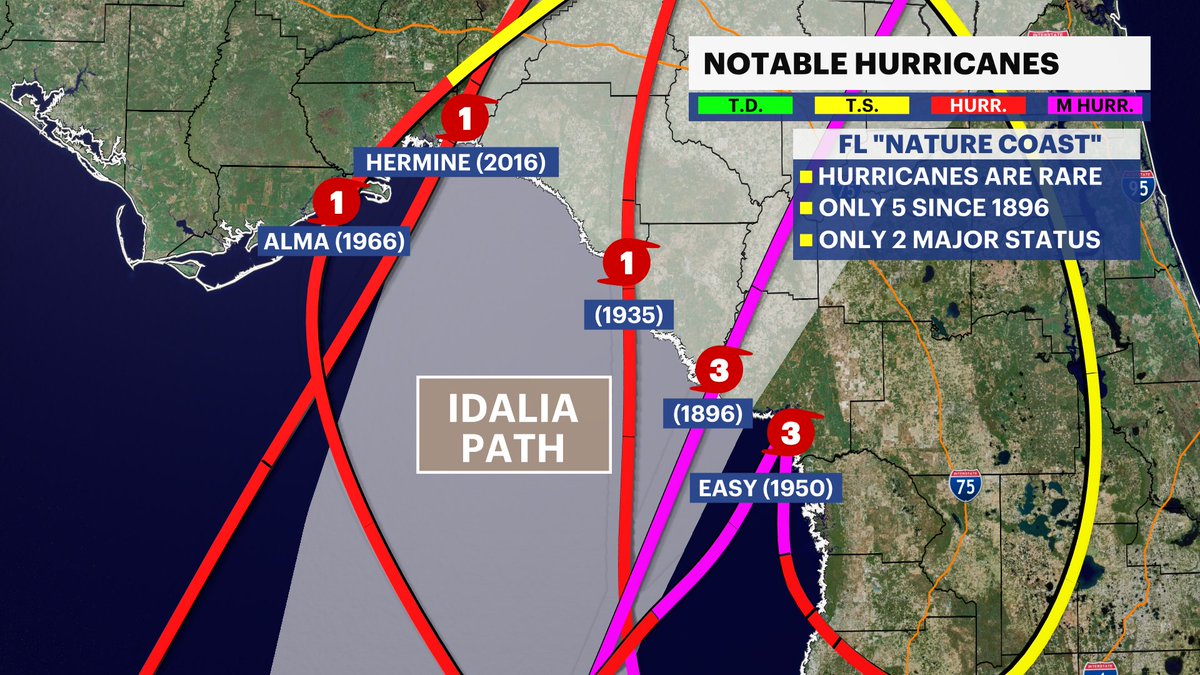
Only one major hurricane has ever made landfall in Idalia's path and it was more than 120 years ago. The storm surge could be historic.
Another concern is flooding from rain. Parts of the GA Low County and Eastern SC Midlands could see 6-8" of rain Wednesday night. #FLwx#SCwx
Did you wake up from the storms last night/early this morning? This animation is a compilation of lightning data (courtesy of @EarthNetworks) every hour beginning 8pm Sat and ending 9 am Sun. About 25,000 strikes (in cloud and cloud to ground) occurred, 14,000 from 2 am to 9 am.
Good morning everyone. The sun is beginning to rise on a cooler and much less humid day. Here is the view from the New London @Earthcam We expect temperatures this afternoon to only reach the upper 70s and lower 80s for highs.
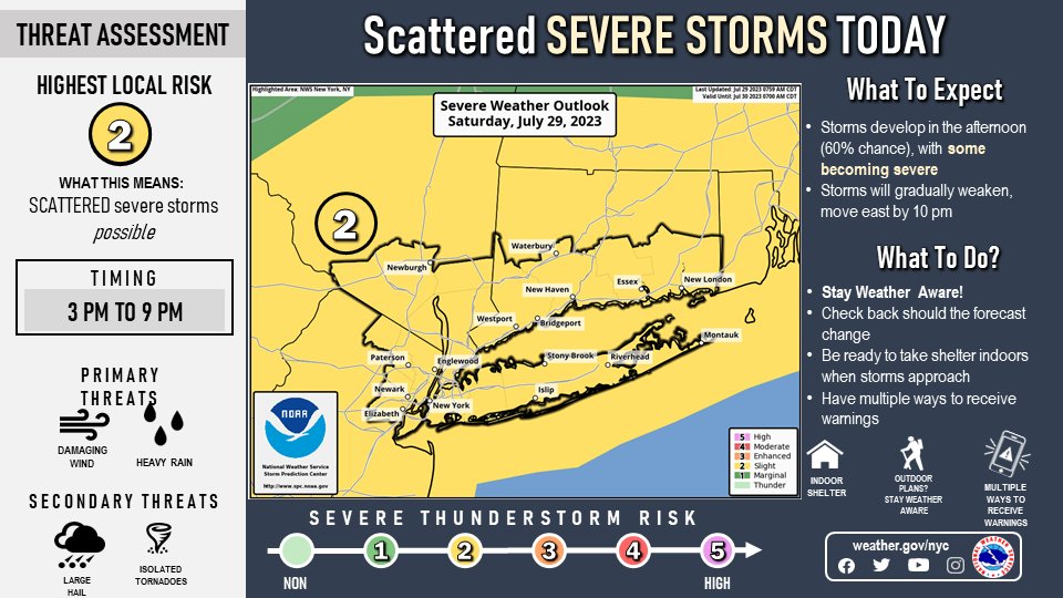
SPC has expanded the slight risk for severe thunderstorms this afternoon and evening to include the entire area. The best timing is from 3 to 9 PM with the primary threat being damaging wind gusts, though large hail and an isolated tornado can't be ruled out. #NYwx#CTwx#NJwx
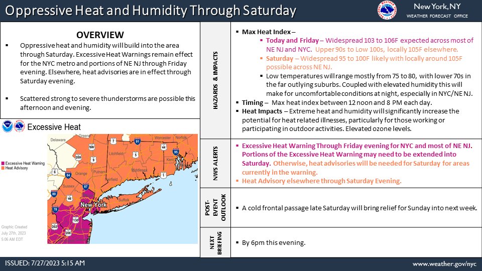
Here's todays briefing on the excessive heat and humidity through Saturday. In addition, there is potential for strong to severe thunderstorms with a localized flash flood threat this afternoon into evening. #NYwx#NJwx#CTwx
Hot and humid conditions continue for Thursday as high pressure both aloft and at the surface will be in control. High temperatures will be in the mid 80s to lower 90s. #NYwx#NJwx#CTwx
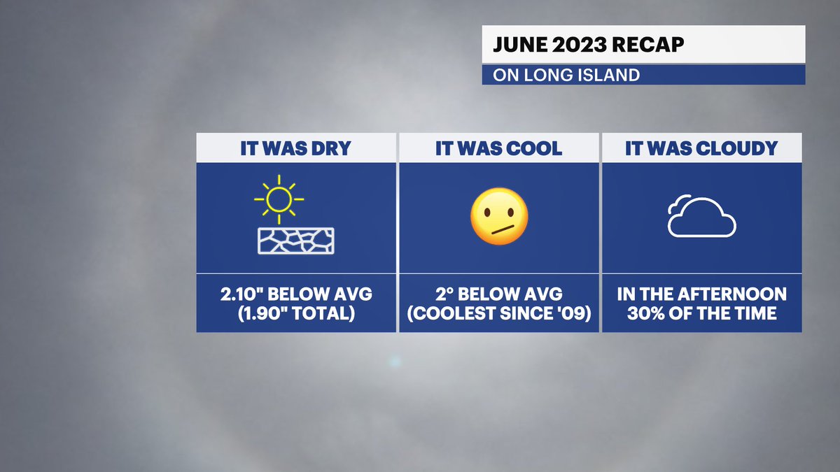
June is over! It was our coolest since 2009 on Long Island. Temperatures ran about 2F below average.
It was also cloudier and drier than average. We're starting off the hottest month of the year in drought.
#NYwx#LongIsland#NYCwx#Summer
⚠️An Air Quality Alert has been issued by @NYSDEC for New York State today.
Smoke concentrations will lead to a decline in air quality. Those sensitive to pollutants should consider limiting outdoor activity to reduce the risk of health effects.
More: https://t.co/ChRuWv7X6E