Luego del sismo magnitud 7.4 al suroeste de Huixtla y los registrados en Ciudad Hidalgo, conversé con los gobernadores de Chiapas y Tabasco, estados que no reportan daños hasta el momento. Se activan protocolos en entidades colindantes.
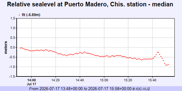
La Secretaría de Marina recomienda no acercarse a esas playas en las próximas seis horas por riesgo de tsunami. Es importante seguir las recomendaciones de Protección Civil.
Autoridades de los tres órdenes de gobierno realizan recorridos en territorio para evaluar posibles afectaciones estructurales y coordinar medidas preventivas. Continuaremos con la información.
El Instituto de Geociencias de la Universidad de Panamá,
Reporta el siguiente evento:
SISMO REGIONAL
Estado: PRELIMINAR
Fecha: 2026-07-17
Hora: 10:19:10AM hora local
Magnitud: 6.2
Profundidad: 6.2km
Localizado en Cerca de la costa de Oaxaca a Mexico
El Instituto de Geociencias de la Universidad de Panamá,
Reporta el siguiente evento:
SISMO REGIONAL
Estado: PRELIMINAR
Fecha: 2026-07-17
Hora: 9:48:28AM hora local
Magnitud: 7.4
Profundidad: 10km
Localizado en Cerca de la Costa de Chiapas a Mexico
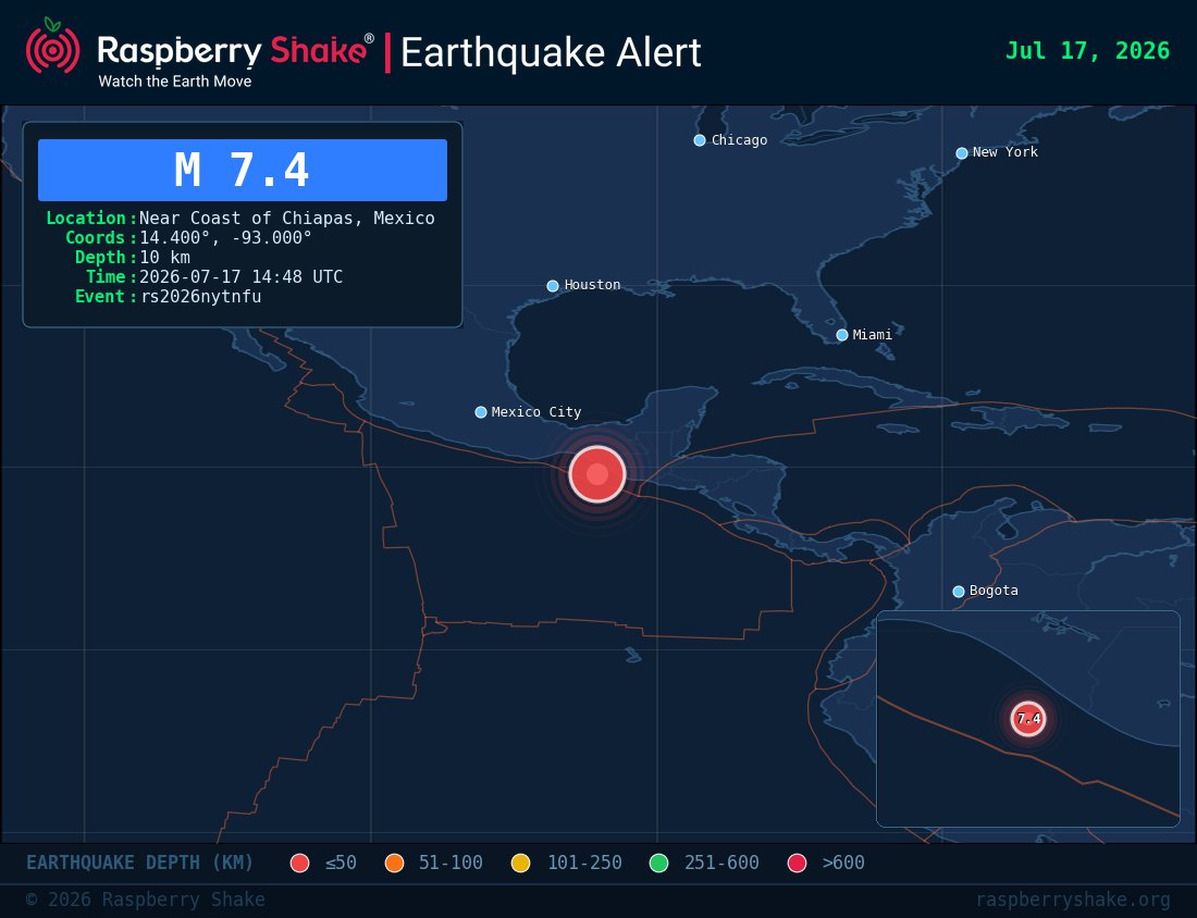
🚨 Preliminary M 7.4 earthquake detected
📍 Near Coast of Chiapas, Mexico
📏 Depth: 10 km
🕒 2026-07-17 14:48 UTC
🏢 Source: #USGS
🆔 #rs2026nytnfu@raspishake
Event ➡️ https://t.co/GAstTUetpp
Join the largest #CitizenScience EQ community ➡️ https://t.co/Y5O0dgJqJF
13 July 1974 1:18 UT (20:18 of 12th LT)
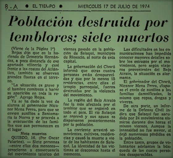
Mw7.1 #earthquake at the Darién Gap, on the Panama-Colombia border, destroyed houses and caused landslides, killing 11 in Colombia. In 1976, a Mw7.3 EQ happened near.
https://t.co/mDHxO91AtP
https://t.co/VB7d0KXxHL
https://t.co/Kh8oofBkXZ
AI is helping us better understand how landslides occur – so that we can reduce risks.
Researchers at @RITtigers used landslide aerial views, elevation data andmachine learning to accurately identify landslide movements.
Learn more ➡️ https://t.co/iNLEZ0joJ2
11 July 1976 20:42 UT
Mw7.3 #earthquake at the Darién Gap coast, Panama, near the border with Colombia, causing damage in houses. Felt from Panama City to Bogotá. Small #tsunami.
https://t.co/hAdq7Ookm0
https://t.co/efiBmKe2pm
https://t.co/yJb4cWY6qd
https://t.co/Kh8oofBSNx
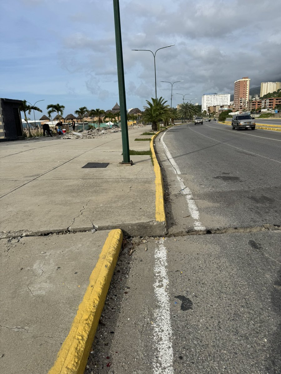
#9Jul#LaGuaira@YosseCcs: Desplazamiento suficiente para una tragedia. Aproximadamente 57 cm.
Es simplemente, para la geología, una corteza terrestre que decide cuándo y dónde moverse, aunque para nosotros a escala humana; signifique devastación, luto y mortandad.
📍Ubicación: Avenida Soublette a la altura de la zona de Macuto / Camurí Chico. La Guaira.
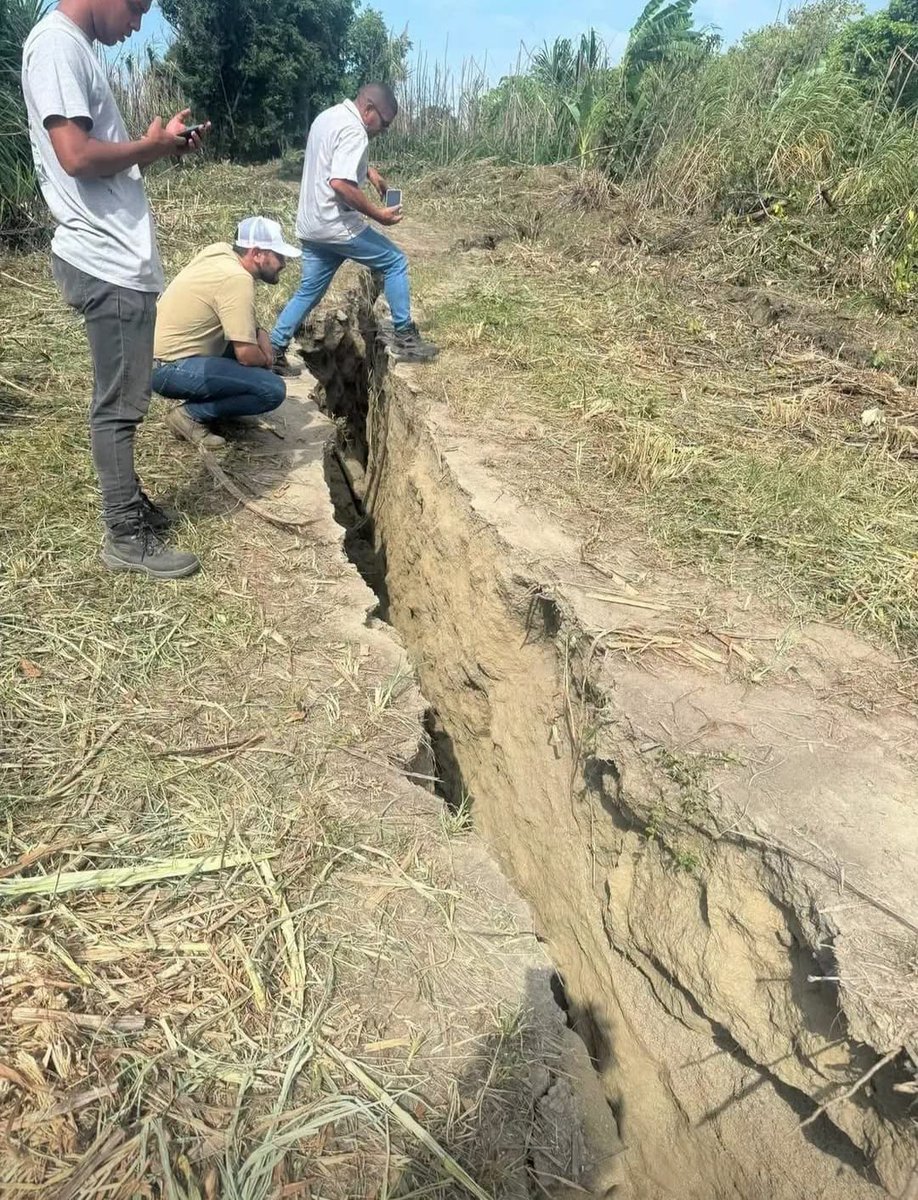
Gempa Venezuela yamh terjadi akibat pergeseran shallow strike-slip faulting (sesar geser dangkal) menciptakan dugaan surface rupture, menyebabkan pergeseran di sepanjang jalur sesar yang merusak infrastruktur, jalan, dan permukiman.
---
@Mas_Annadwi
Source : Instituto Nacional de Geología y Minería (INGEOMIN)
Doble terremoto ¿Qué pasó?
El 24 de junio de 2026 hubo un "doblete sísmico" en #Venezuela. Aquí una explicación breve de lo acontecido en términos sísmicos ⬇️
Missing the fault motion of Tacagua fault on slip modeling? This unwrapped ifg from ascending trajectory of S1 shows surface deformation associated to the Tacagua-Avila fault in Caracas. #USGS#Venezuela#Sentinel#earthquake#NISAR
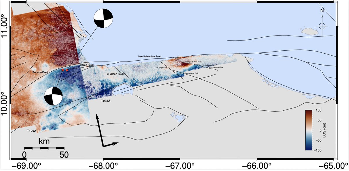
Así se desplazó el terreno en Venezuela.
Este mapa, elaborado con datos del satélite NISAR mediante tecnología de radar (InSAR), muestra el movimiento de la superficie comparando imágenes tomadas antes y después del sismo.
🔴 Rojo: desplazamiento hacia el este.
🔵 Azul: desplazamiento hacia el oeste.
🟡 Amarillo: desplazamiento mínimo o nulo.
El mapa muestra el desplazamiento real del terreno, que fue principalmente horizontal.
What happened during the #Venezuela earthquake doublet (Mw 7.2–7.5)?
No single method can explain a major #earthquake on its own. By combining seismology, finite-element fault modelling, InSAR and seismic intensity, we can reconstruct how the rupture occurred and why the effects varied so much.
This map (Figure 1) shows the tectonic context of the event.
It includes active faults, historical earthquakes, focal mechanisms and plate boundaries, demonstrating that northern Venezuela forms part of one of the most tectonically active regions in the Caribbean.
The focal mechanism (known as a ‘beachball’) indicates how the fault moved during the earthquake.
It does not represent the shape of the fault, but rather the orientation of the rupture plane and the type of movement that released the energy accumulated in the Earth’s crust.
The finite fault model (Figure 2) shows what the epicentre cannot.
The epicentre is merely the point where the rupture begins. The finite fault model reveals which part of the fault ruptured, how the rupture propagated and where the greatest slip occurred.
In this case, the rupture was consistent with predominantly strike-slip motion along the San Sebastián fault system.
The distribution of slip helps to explain why some areas experienced much more intense shaking than others.
InSAR data from the Sentinel-1 satellite (Figure 3) allow direct measurement of ground deformation.
By comparing radar images taken before and after the earthquake, it was possible to detect displacements of around 30 cm along the satellite’s line of sight. The interferogram confirms the deformation expected from the finite fault model. Whilst the finite element model estimates the slip that occurred at depth, InSAR measures the deformation that this movement caused at the Earth’s surface.
The Modified Mercalli Intensity (MMI) map (Figure 3) represents something different from magnitude.
Magnitude measures the energy released by the earthquake; intensity describes how the ground motion was felt and what its effects were at each location.
The highest intensities are concentrated near the area where the greatest fault slip occurred.
However, local geology also plays a role. Soft soils and sedimentary basins can amplify seismic waves, causing stronger shaking than in nearby areas.
Understanding a major earthquake requires integrating multiple sources of information. Regional tectonics, focal mechanisms, finite fault models, InSAR and intensity maps provide complementary pieces of the same jigsaw puzzle. Together, they enable us to understand how the rupture occurred, how the ground deformed and why the damage varied so much, thereby improving the assessment of future seismic hazard.
3/ Lo que sí existen son sistemas de alerta temprana sísmica. Funcionan cuando el terremoto ya ha empezado.
Detectan las primeras ondas sísmicas y, si el sistema calcula que la sacudida puede ser importante, envían una alerta. ⚠️📲