#MiPaís 🇨🇴 | Parques Nacionales Naturales de Colombia compartió una imagen que evidencia la presencia de un puma (Puma concolor) en el Parque Nacional Natural Pisba, una de las áreas protegidas más importantes del país para la conservación de los ecosistemas de páramo.
El avistamiento se registró en medio de la neblina característica de estas montañas y confirma la permanencia de este felino en sectores de Socotá, Socha y Tasco, donde su presencia ha sido documentada a través de cámaras trampa, monitoreos de guardaparques y reportes de las comunidades locales.
🐾 Considerado uno de los principales depredadores de América, el puma cumple un papel fundamental en el equilibrio de los ecosistemas y es un indicador de la salud ambiental de los territorios que habita.
📷 Carlos Albeiro Vega
New ESA EO4Society project: VESTO 🌍it explores the vertical distribution of stratospheric and tropospheric ozone by combining TROPOMI and CRIS measurements, helping to advance atmospheric composition research.
More info: VESTO project page 👇https://t.co/btbB9axSCW
@ESA_EO
📆 22 - 23/May/2023
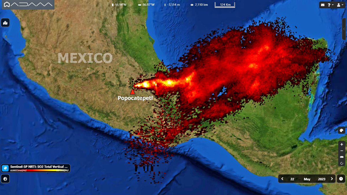
Las lecturas del satélite Sentinel-5 Precursor (del programa Copernicus) con instrumento de respaldo TROPOMI (Troposheric Monitoring Instrument), detectaron una extensa columna de dióxido de sulfuro, que, impulsada por las corrientes de viento en altura, amplificaron la dispersión en gran parte de la Bahía de Campeche y la Península de Yucatán; así como también en estados de: Puebla, Oaxaca, Veracruz, Tabasco y Chiapas.
Hasta las 19:50 hrs del día 23, tras aproximadamente 72 horas sostenidas del segundo paroxismo, los niveles de actividad volcánica en todos sus parámetros de medición comenzaron a disminuir drásticamente, en donde se apreciaron intermitentes exhalaciones de ceniza.
📹 Vídeo. Continuación del segundo paroxismo en el amanecer del 23/May/2023. Campion, R. (2023).
📹 Animación. Evolución en los conos de dispersión de cenizas del Popocatépetl entre el 19 y 23/May/2023. Modelado por Sismo Alerta Mexicana (2023).
9/n
BRAVA NEWS presenta un recuento de imágenes satelitales que demuestran cómo a través de los últimos años se fue extendiendo la minería ilegal de oro al interior del Batallaron Rifle 31 en el departamento de Antioquía. Esto se da luego de la denuncia realizada por el fotoperiodista @federicorios para el @nytimes #MinaLaMandiga #MineriaDeOro #Caucasia
In Barcelona, geometrically and historically distinct urban forms coexist. In this capture from our Pelican constellation, the rigid superblocks of Eixample contrast with the winding streets of El Raval. The city is legendary for its architectural diversity and innovative design, visible even from orbit.
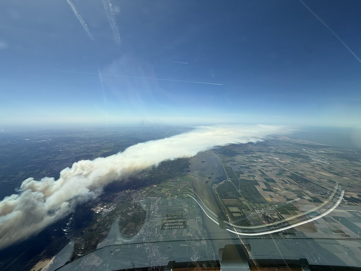
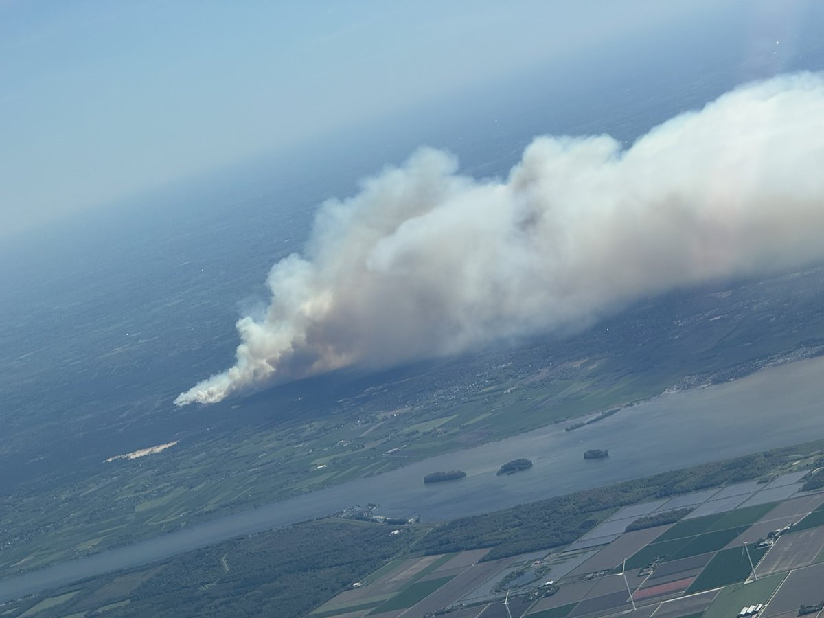
The Pineland Road Fire continues to burn in south Georgia this afternoon, and @NOAA's #GOESEast (#GOES19) has been tracking the smoke and heat from the blaze. According to @GaTrees, the #wildfire has scorched nearly 9,000 acres and is only 10% contained.
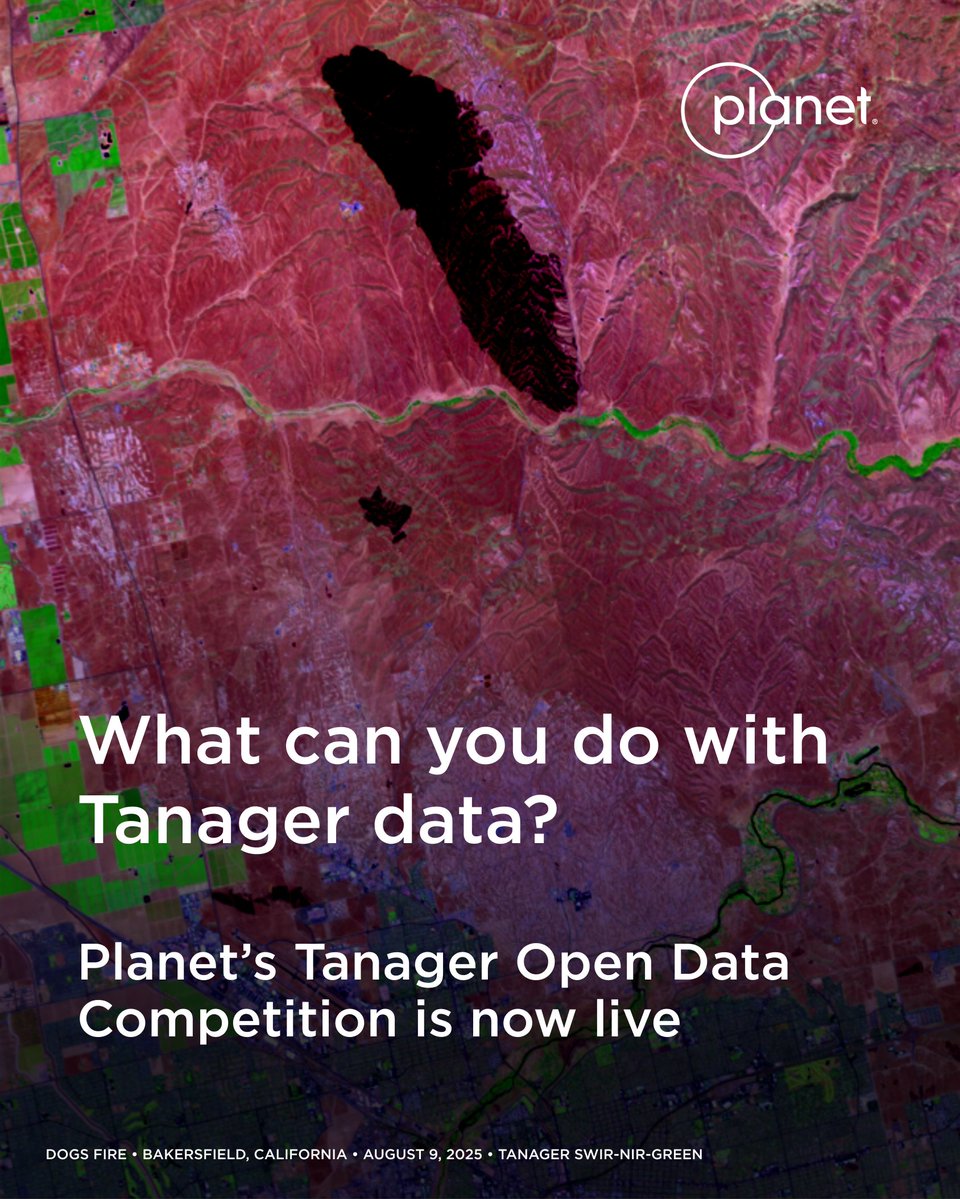
We’re calling on researchers, students, and analysts to put hyperspectral data to use. 📣 Our Tanager Open Data Competition is now live! Participants can use our Tanager open source imagery to showcase real-world examples that are helping make a difference for life on Earth.
Learn more about the competition and register here: https://t.co/LdcD3xwf8Q
Muy de acuerdo con tu planteamiento Alfred y completamente de acuerdo tambien de la necesidad de un satélite ambiental, pienso que combinando estas fuentes de datos con modelos quimicos de transporte puedes tener más informacion temporal y así no ver solo esa mancha estática para un momento del día y con ello poder atribuirle direcciones de transporte y deposiciones.
Este es el tipo de información que nos inspira: satélite de la @NASA permite ver dónde empieza la contaminación del aire.
¡Nosotros en la @CAR_Cundi ya damos los primeros pasos de la mano de @Romsenteret para tener el primer satélite ambiental del país!
https://t.co/nDsS8v2DNb
The Moon, revealed through its geology. 🌗
Explore the Unified Geologic Map of the Moon! Created by @usgs_astrogeo, in collaboration with @nasa and other partners, this first-ever comprehensive map reveals the Moon’s entire surface geology, combining Apollo-era data with recent satellite missions.
It not only shows the 4.5-billion-year history of our lunar neighbor, but also serves as a key tool for future human missions and an invaluable resource for scientists, educators, and space enthusiasts.
Download the full map and legend 👉https://t.co/CB96bZoIZu
📹: This animation shows a rotating globe of the Unified Geologic Map of the Moon with shaded topography from the Lunar Orbiter Laser Altimeter (LOLA). Credit: NASA/GSFC/USGS.
#NASA #Moon #GeologicMap
New record🥇
The Artemis II astronauts are now farther from Earth than humans have ever been! At 1:57 p.m. EDT, they broke the record set by Apollo 13 in 1970.
Their journey around the far side of the Moon today will take them a maximum distance of 252,752 miles from Earth.