Three years ago today, war broke out in Sudan, leading to the largest humanitarian crisis of the 21st century with unimaginable atrocities committed against civilian populations.
Since then, Sudan Witness has systematically documented conflict-related incidents and harm to civilians using open-source information, analysing over 10,800 pieces of data to build an evidence base of events on the ground.
Today, we are launching the Sudan Witness Data Hub, bringing together all of our maps, datasets, and dashboards in one place to support researchers, journalists, humanitarians, and others working to keep eyes on Sudan, pursue accountability, and protect civilians. 1/6
So happy that my PR was merged into @openglobus! 🌍
I just realized this is the first time in years I’ve voluntarily contributed to an open-source project. Even if the contribution is small, it’s important to give back to the projects we love.
Today's Sentinel-2 image of El Fasher is out. Visible red dots are concentrated in the eastern and southern areas. While their nature is uncertain, one dot in the northwest appears to be the roof of the Saudi hospital, not a fire. Again not yet available on the Copernicus website
"Sentinel-2 imagery (July 13, 08:16 AM) shows what appear to be combat-related fires in Um Semima, Sudan. This comes amidst conflicting reports of RSF capturing the area, followed by claims from the army of regaining control of the strategic location.
#KeepEyesOnSudan
Sentinel-2 infrared imagery from June 4, 2025, reveals a fire spot at Nyala Airport. This corroborates recent reports of the airport being targeted multiple times in recent days.
#KeepEyesOnSudan
وشهد مطار نيالا الدولي سلسلة انفجارات أيام السبت والأحد والأربعاء استهدفت محيط المطار وأجهزة تشويش وجهاز الانذر المبكر وفقًا لشهود عيان وثلاثة مصادر متطابقة تحدثت لـ”دارفور24″.
Our first Python course for the Sudanese community in Vienna has successfully concluded! The "What's Next" presentation was introduced by Lubomír Doležal from @pyladies_vie, and featured insights from amazing PyLadies mentors, including @__fschindler__ from @getsentry!
From practical sessions on CV writing to foundational programming, like our recent Python course, we're proud of the progress our community has made!
Explore our initiatives and learn more: https://t.co/3zfZUVBr55
Around a year ago, the Sudan Club in Wien embarked on an inspiring journey, launching our dedicated Training Unit. Our aim: to empower the Sudanese community in Austria by providing free workshops and courses to enhance skills for both the job market and daily life.🧵
The war in #Sudan has profoundly impacted its environment but these consequences have received little attention.
Our new overview details key incidents and trends that pose risks to Sudan’s people and ecosystems. https://t.co/wvdzJp7ejT 🧵⬇️1/7
#السودان
@tom_bike@byjepstein@esa@EU_Commission@Osinttechnical@Element84 Interestingly, US companies – Element84 and Sinergise (now Planet Labs) – handle the management of ESA's data, hosting images on Amazon's US-based cloud storage. I believe Copernicus is planning a migration to alternative EU solutions.
@tom_bike@esa@EU_Commission@tom_bike I had a similar issue yesterday, and looking at Sentenil hub EO browser, it’s also missing some spots over Yemen, both are using different API’s for the images ( CDSE & sentinel-hub).
I would look for the images in element84 buckets. (When I’m home tomorrow )
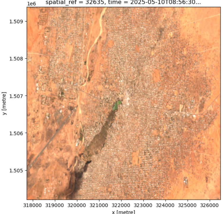
Sentinel-2 imagery from yesterday (May 10th) reveals apparent combat-related fire spots in the southern areas of El-Fasher. Interestingly, these images are not yet publicly available on the Copernicus Data Space Browser: https://t.co/oZj1ujXS9b.
#KeepEyesOnSudan
🟢 لليوم الثاني على التوالي سماع دوي انفجارات في مناطق فشار وكركر و قرقف و جقو جقو شرق مدينة الفاشر، كما رصد مرصد "ناسا" للحرائق عددا من الحرائق في المنطقة
🟢تضم هذه المناطق معسكرا يتبع للمليشيا يحتوي على أسلحة ثقيلة من بينها المدفع الصيني "هاوتزر AH4" الذي يستخدم في قصف مدينة الفاشر ومعسكر زمزم
Multiple fire spots detected by Sentinel-2 imagery today corroborate reports of an RSF attack on Umm Kadadah (~170 km east of El Fasher).
#KeepEyesOnSudan
This animated map imagines rivers standing up like trees. The link shows you an animated globe. Explore the world of river trees and see what your favourite river looks like standing upright! Source: https://t.co/WX0P8mzpHb
The impact of war on livelihoods in Khartoum & El Gezira. The video shows the dramatic decline in nighttime lights (brown spots) from 20.01.2023 (pre-war) to 19.20.2023. Note the relative stability of illumination in SAF-controlled areas. (NASA black marble)
#KeepEyesOnSudan
🛰️See the dynamic change of night-time light in #Khartoum, #Sudan loss of light observed in April & May 2023 by using images acquired by Yangwang-1 Space Telescope night-time data and SDGSAT-1 satellites.
@WHU_1893@UN_Sudan@UNOCHA_ROSEA@Refugees