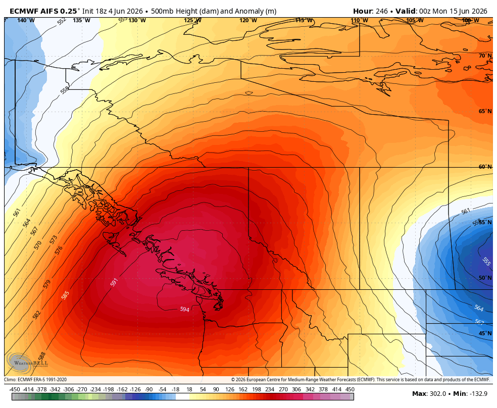
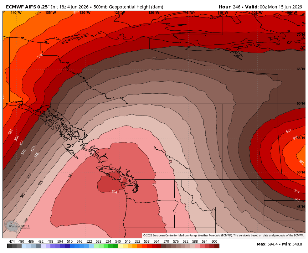
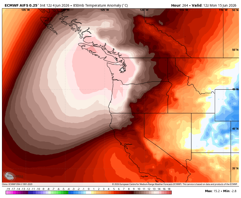
I’ve been seeing a lot of hype and wishcasting for June being cold out West. This is simply not the case. Sure, the first week will be normal/slightly below but not for long. Second week of June is looking quite warm/above normal.
#BCStorm#BCwx#BCStormWatch#ShareYourWeather
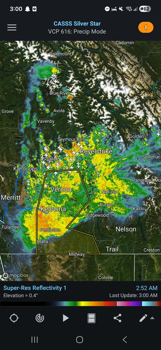
Blustery day in #Kelowna, thanks to an upper-level disturbance rounding the Montana low & the favourably-orientated N-NE flow.
So far, gusts up to 30-60 km/h have been observed since late this morning, & should continue through this afternoon before calming this evening.
Showers or rain will continue or remain possible through much of the Southern BC Interior today as well.
#BCStorm#BCwx#BCStormWatch#ShareYourWeather
Wet and muggy day so far in #Kelowna, as additional, beneficial rainfall passes through! (Currently sitting at 14.4 mm on my PWS)
It should clear out, however, by later this aft or early this eve.
Videos of last night's t-storns will be posted between Sunday & Wednesday.
If you’re in Vancouver & the Lower Mainland check out 😀📖 for a more local approach to my love for weather where you can share local updates and get forecasts for the region. Just search Vancouver & the Lower Mainland Weather Page.
#BCstorm#BCstormwatch#BCwx
#BCStorm#BCwx#BCStormWatch#ShareYourWeather
Storms have moved on, and the warm, steady, beneficial rainfall has moved in, which should work its way through #Kelowna & the Okanagan over the next 2-4 hours or so. 🌧
It wasn't smooth sailing BY FAR, but overall, a relatively successful first thunderstorm event of the year for me 👌.
I need to sleep now. Good night.
(Videos to come later today)
#BCStorm#BCwx#BCStormWatch#ShareYourWeather
After a week of convective/wet weather, with near seasonal-below seasonal highs between the low double digits to low 20s (a few in the mid-20s some days), sunnier, warmer weather has made its return to #Kelowna & much of Southern BC.
(Photos & videos, including some of the past posts with photos/videos, in order from a couple of Tuesdays ago to yesterday)
Today's lovely "blue marble" shot of the eastern Pacific. As captured by GOES-18 at 2100 UTC / 2 PM Pacific, around the time of maximum disk illumination. Received and processed from the 1.7 GHZ radio signal with my own ground station here in Vancouver. Mostly gear from Nooelec.
@bcstormwatch@HawaiiWXdotcom@spann
(1/14)
#BCStorm#BCStormWatch#ShareYourWeather#Hiking
Photos & videos from a ~7 km hike I did along the High Rim Trail (E of #Kelowna#BC), from Postill Lake FSR to just past the 21 km point & back, last Tues aft, taking in what was the final very warm, dry day before the...
#BCStorm#BCwx#BCStormWatch
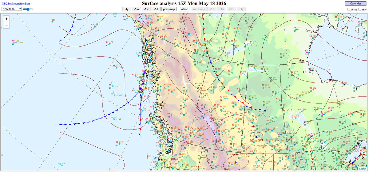
Today & tmrw, a cold, NW flow with embedded disturbances/shortwaves will impact Southern BC.
Today, in tandem with marginal instability, daytime heating, & weak deep-layer shear, as well as orographic lift, steep lapse rates, & weak SFC features (low(s) &/or trough(s)), this’ll lead to continued isolated-scattered/patchy precip/convection, which has been ongoing since yesterday, with the risk of isolated t-storms from this afternoon, into this evening, across the Interior.
While the Interior t-storm threat & convection will come to a gradual end in the evening, due to a weak SFC system, patchy-widespread precip that'll impact the North Island, North Sunshine Coast, & Central Coast this afternoon will either develop or work its way into & impact the Central Interior, North Thompson, & Columbias this evening through into tmrw morning. Patchy-widespread precip will continue to impact parts of the coast during said time as well.
#BCStorm#BCwx#BCStormWatch
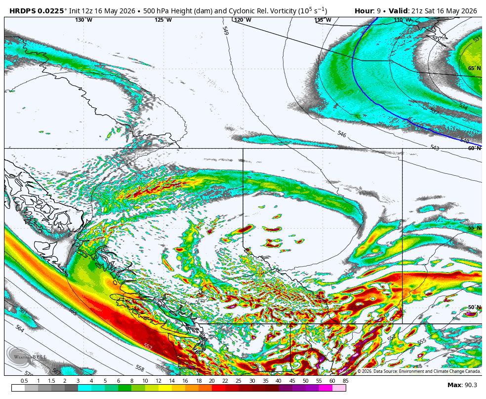
A very cold, broad area of low pressure (that at times will have two or more areas of circulation), with embedded disturbances/shortwaves in its periphery, will impact Southern BC today, before moving fully out of the region tonight. Then, for the rest of the night tonight & tmrw, a cold, NE-NW flow with potential embedded disturbances/shortwaves will be expected as weak upper ridging moves in.
In tandem with marginal instability, at least marginal heating, & weak deep-layer shear, as well as orographic lift, steep low-level lapse, & weak SFC features (low(s) &/or trough(s)), this’ll lead to continued patchy-widespread precip/convection, which has been ongoing since yesterday, with the risk of isolated-scattered t-storms from now, into this evening, across Southern BC.
While the t-storm threat will end in the evening, patchy-widespread precip/convection will continue through tonight, but gradually diminish with time, with dry conditions (a few, isolated areas of precip/convection possible in the Interior) expected by early Sunday morning across Southern BC.
Isolated-scattered precip/convection will reignite late Sunday morning or early afternoon across Southern BC, continuing through the aft, before gradually diminishing in the eve, with only a few, isolated areas of precip/convection at most expected by midnight. An isolated t-storm threat across the Interior will accompany the precip/convection during the aft-eve period. It'll be driven by the cold upper-level flow with potential embedded disturbances/shortwaves aforementioned, in tandem with marginal instability, at least marginal heating, & marginal deep-layer shear, as well as orographic lift, steep low-level lapse, & weak SFC features (low(s) &/or trough(s)).
Heavy downpours (or snowfall in high elevations), hail or graupel/snow pellets up to 0.25-0.5 inches/~0.5-1.25 cm, and wind gusts up to 50-60 km/h will be the main concerns in non-TSTM/TSTM convection both days. Due to the cold upper-level system & related instability, while lower potential than yesterday, last night, & this morning, funnel clouds/waterspouts will still be possible over the Georgia Strait & waters off the West Island this afternoon.
Overall, across most (if not all) of Southern BC, from early this morning to late tmrw evening, <1-5 mm to up to 15-25 mm of rain is expected.
Both the highest totals, & greatest possibility for locally higher totals (as high as 30-40 mm), will tend to occur where moderate-heavy rain/convection &/or any t-storm(s) pass over (particularly repeatedly).
Meanwhile, thanks to the cold air, for most (if not all) mainland high elevations, <1-5 cm to up to 30-45 cm of snow is expected! The highest totals will reside in the highest peaks of the Coastal Mountains & Koots-Columbias, w/ locally higher totals also possible.
Some lightning & thunderstorm chances across inland Vancouver Island (Victoria/Port Alberni maybe?) with a risk speckled across the Interior as well... all driven by a cool upper trough. #BCStorm