I'm so incredibly proud and excited to see the announcement of the Exyn Nexys to the world. This has been the most challenging, complex, and rewarding project that I've had an opportunity to lead. In less than 12 months we've gone from concept to launch!
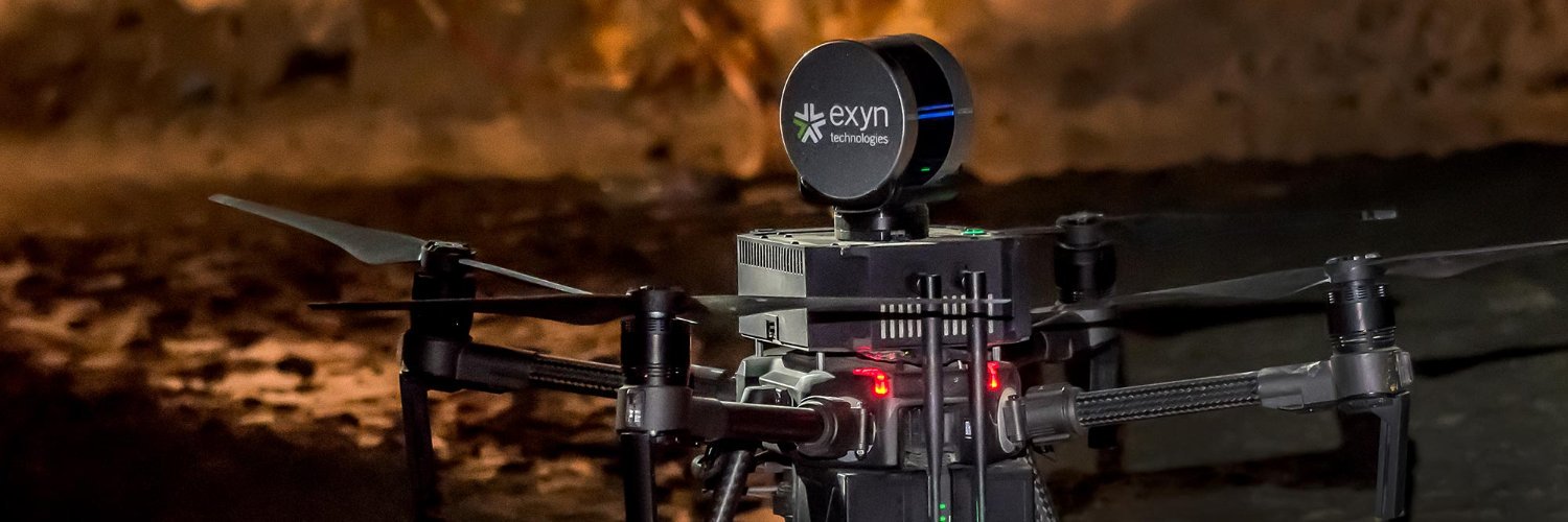
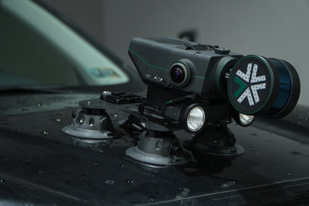
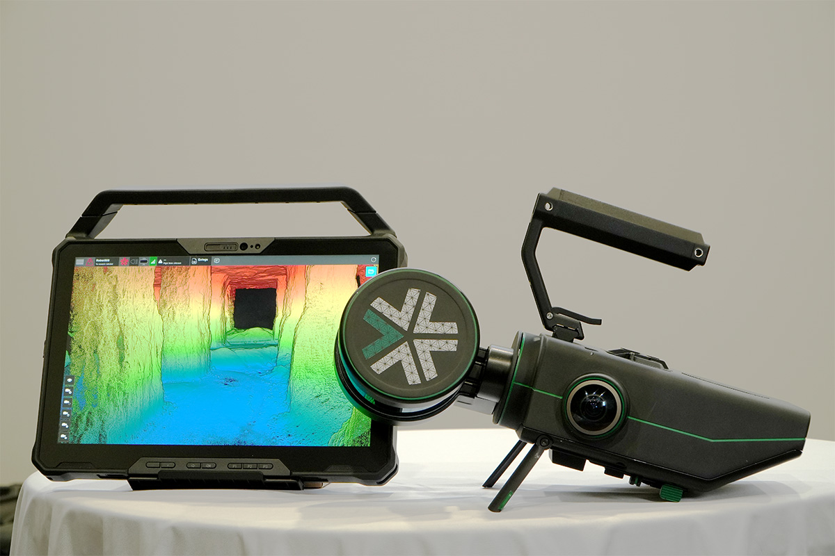
Introducing Nexys. A modular mapping & surveying ecosystem that allows users to quickly capture highly accurate, colorized, real-time 3D point clouds in complex, GPS-denied environments. Autonomous when you need to explore, modular when you can capture by hand. #geoweek ... 0/8
@ExynTech recently announced that its modular 3D mapping solution, Nexys, is now compatible with the IF800 Tomcat system from @InspiredFlight1 (IFT), a U.S.-based manufacturer of unmanned aerial vehicles. 🚁 🗺️
https://t.co/pVPj2TchSR
It's almost that time of year 🍾⭐🍸
MistyWest and @Memfault are hosting the 8th annual FOUNDERS & FRIENDS in Las Vegas on Jan 9.
We're bringing together hundreds of key players in hardware for a "one-night mini incubator" during @CES.
Learn more: https://t.co/qGvbRHPV8z
Solar storms disrupting robot tractors showcase the limits of using automated systems in the real world.
But true autonomy is here! The Nexys mapping & autonomy ecosystem enables navigation w/o external inputs - mapping faster, safer & more efficient. https://t.co/L4pByxcg3q
For those who don't already know, @ExynTech is a phenomenal company. Congratulations to them for building amazing solutions, finding wonderful customers and solving difficult real-world problems in the process.
Exciting News from @ExynTech! 🚀
I am thrilled to announce that @ExynTech has secured an additional $5 million in funding to fuel our strategic growth initiatives. This investment will accelerate our product development and market expansion, enhancing our ability to deliver cutting-edge autonomous solutions for complex, GPS-denied environments.
With this boost, we'll continue revolutionizing industries like mining and construction, making data capture faster, safer, and more efficient. A big thank you to our investors and our board for their confidence and support!
https://t.co/EjPZyeDliC
🚀 Join @ExynTech TOMORROW for an insightful webinar on "Precision Decisions: Expanding the Surveyor Toolkit with Portable 3D Mapping" 🌍
Discover how cutting-edge 3D mapping technology is revolutionizing the surveying industry. This webinar, hosted by @GeoWeekNews, will delve into the latest portable 3D mapping tools that enhance accuracy and efficiency in surveying projects.
📅 Date: July 2, 2024
🕒 Time: 1300-1400 ET
📍 Location: Online
Why attend?
✅ Learn about innovative 3D mapping solutions
✅ Enhance your toolkit with portable technology
✅ Gain insights from industry experts like Justin Thomas
Don't miss out on this opportunity to stay ahead in the ever-evolving field of surveying. Register now and take your skills to the next level!
🔗 Register Here:
https://t.co/SxCpGUrl4T
Join @ExynTech for an in-depth exploration of cutting-edge advancements in autonomous technologies and mobile mapping solutions that are revolutionizing mining survey efficiency.
Save your spot here: https://t.co/nUPUB1mSV6
#Robotics#AI#Innovation
Join @ExynTech for an in-depth exploration of cutting-edge advancements in autonomous technologies and mobile mapping solutions that are revolutionizing mining survey efficiency.
Save your spot here: https://t.co/nUPUB1mSV6
#Robotics#AI#Innovation
Complex, dangerous and inhospitable environments are not where most people would prefer to work... this is where a modular mapping and surveying ecosystem comes into play. Take a look at this.
https://t.co/QToCGmiCsz
@ExynTech#mapping#geospatial#surveying
Exyn Technologies has announced Exyn Nexys, a modular 3D mapping solution designed to meet the unique needs of the mining industry, among others, at the SME MineXchange Conference and Expo, in Phoenix, Arizona | https://t.co/UCIaQWeRgs @ExynTech@smecommunity#minemapping
Designed for professionals in construction, AEC, geospatial, and mining, @ExynTech’s Nexys is a complete mapping and surveying ecosystem that allows users to quickly capture highly accurate, colorized, real-time 3D point clouds. https://t.co/GfCh9zklkw
I'm grateful to have the opportunity to work with such a talented team at @ExynTech and shout out to @MistyWestYVR their team for all the contributions to bring this product to life.
I'm so incredibly proud and excited to see the announcement of the Exyn Nexys to the world. This has been the most challenging, complex, and rewarding project that I've had an opportunity to lead. In less than 12 months we've gone from concept to launch!
Introducing Nexys. A modular mapping & surveying ecosystem that allows users to quickly capture highly accurate, colorized, real-time 3D point clouds in complex, GPS-denied environments. Autonomous when you need to explore, modular when you can capture by hand. #geoweek ... 0/8
The new release is @ExynTech latest 3D mapping solution, and the announcement has been made ahead of @GeoWeekNews 2024, taking place in Denver, Colorado February 11-13. The Exyn Nexys is a modular 3D mapping solution that can be used as a handheld device as well as an attachment to a drone, ground robot, vehicle, or backpack.