🦜 Can #SDMs and satellite #LiDAR improve conservation planning? In Peru, models for seven threatened species reveal key ecological corridors, gaps in protected-area coverage, and how GEDI data can support #connectivity and conservation.
🔗 https://t.co/zTvIlERk9g
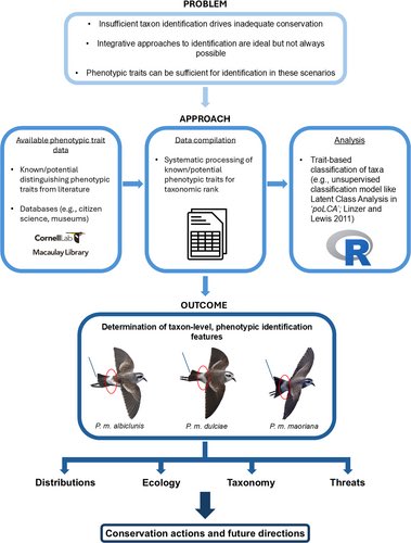
🔎 Can #citizenscience photos solve the identification gap?
Using trait-based analysis of >1000 storm petrels, this study distinguishes cryptic taxa and reveals unexpected movements, showing how public datasets can improve #speciesmonitoring.
🔗 https://t.co/sUo7JwP0ZG
🌱 Do photosynthetic pathways shape invasion risk? In Hawaii, #C4 grasses show the greatest range expansion under #climatechange, especially at low elevations, while C3 groups decline or shift, highlighting pathway-based insights for #invasionscience.
🔗 https://t.co/3g6MnIuUYK
How well is freshwater #biodiversity represented in #ProtectedAreas? Employing species distribution modelling (#SDMs) and spatial prioritization analyses for 1313 fish species of Colombia, only 25,2% of suitable habitats overlap with existing PAs.
🔗 https://t.co/QPevAJb2W1
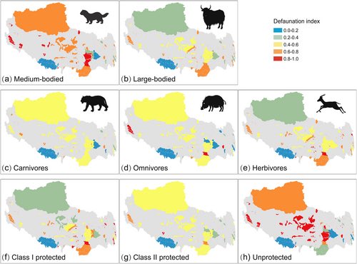
🏔️ Are #ProtectedAreas effective in extreme #ecosystems? Across Tibet, stricter management and higher habitat heterogeneity boost mammal diversity, but medium-sized herbivores show high #defaunation, highlighting the need for tailored PA management.
🔗 https://t.co/u1iQsnNpYL
🗞️New data article out by @Martin_Ecology et al. presenting a set of new openly-available #EcologicalUnits (or zoning) layers for Europe at 100 m spatial grain for a 18 year time series.
https://t.co/fh0Kg68QJR
“Conservation requires looking beyond Red Lists alone. Across European #foodwebs, non-threatened species play a strong role in maintaining #networkconnectivity.”
🗞️Check out this new paper by F. Mestre, @Araujo_lab et al!
https://t.co/HFxAVGpZZd
🐠 Which reef fishes yield reliable #SDMs? Analysing 1900+ species, this study shows #modelperformance mostly depends on latitude and coastal proximity, offering a framework to predict reliability and improve #marinebiodiversity assessments.
🔗 https://t.co/vzlXQPauvk
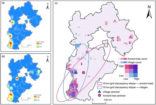
🌳Distribution patterns and maintenance mechanisms of ancient trees in traditional villages and their surroundings in Hebei Province, China
#culturalheritage#rurallandscape#spatialheterogeneity
🔗 https://t.co/1iz322xoVL
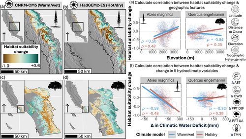
🌿 Where will California’s plants find refuge under climate change? Modelling 81 species shows highly variable shifts, often shaped by minimum temperature responses and topographic complexity. 🌡️ #ClimateChange#PlantEcology#Refugia#SDMs
🔗 https://t.co/NBM60Gzkcm
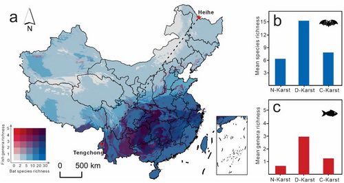
🦇🐟 In China’s karst systems, shifts in #bat distributions reduce guano supply, amplifying projected #CaveFish richness losses by up to 40×. A reminder to integrate biotic interactions into #SpeciesDistributionModels and #Conservation planning.
🔗 https://t.co/SYibbvJR8Q
New Data drop led by Quiang Zhang
🦆The first global, annual (2000–2022) habitat maps tailored to avian influenza host birds
🗺️300m resolution
🌾8 Level-1 & 34 Level-2 habitat types
A new environmental layer for large-scale host–environment research
🔗 https://t.co/SpUKUtOTS3
🦜 Can we map #bird communities, not just species? Using 50 years of #CitizenScience data, this study defines 29 distinct bird communities across Australia, providing a new continental framework to assess community condition and track change over time.
🔗 https://t.co/fNqKXkK7Q9
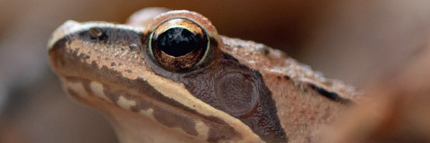
🐸 This new paper led by Travis A. Rainey shows high #GeneticDiversity but strong isolation, driven by development, of Blanchard’s Cricket #Frog found at northern peripheral sites; declines likely stem from demographic rather than genetic pressures.
🔗 https://t.co/1ugZKbDpVk
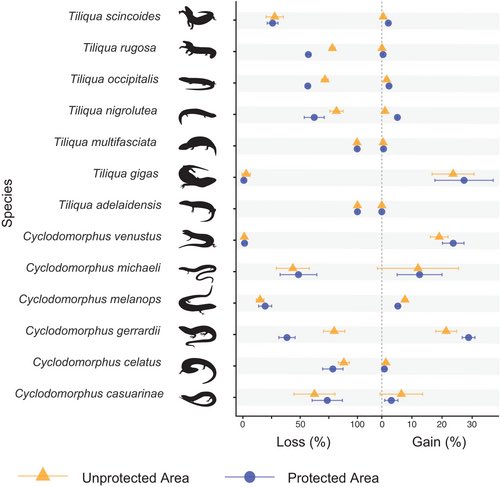
🦎 Trafficked lizards likely won't keep up with climate change. Limited movement and patchy protection could mean major habitat loss ahead.
#WildlifeTrade#Conservation
🔗 https://t.co/ulMhkKdg2k
New cover page! 🪸
https://t.co/QtKZH7ndpR
“Seascape genomics reveal contracting population structure in sympatric and congeneric corals across thermal clines” by Marzonie et al.
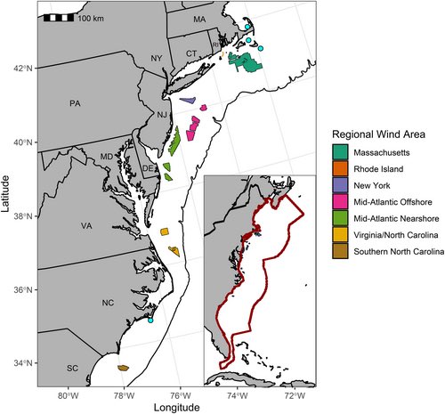
🐢 Where do leatherback #SeaTurtles overlap with offshore wind energy? Tracking 74 individuals along the US Atlantic coast, this study maps seasonal core #habitats and reveals peak overlap in some areas.
🔗 https://t.co/7Z8pvP7217
Many species not yet formally recognised may already be at risk of extinction. The findings underscore the urgent need for more fieldwork in understudied areas 📉 New paper @consbiog@FarooqHarith@jgeldmann@FaurbySoren#conservation 👇
https://t.co/KbSNXgQjzI
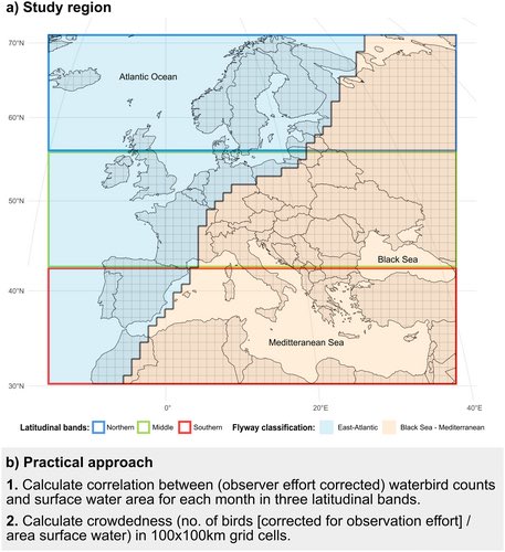
🦆 When do waterbirds need water most? Using #Copernicus data + bird counts, this study maps where surface water limits #waterbirds across the Western Palearctic, revealing seasonal bottlenecks and priority areas for #restoration and conservation.
🔗 https://t.co/Z79rTecXXK