I don’t care how old or young you are. You should be reading.
Reading is essential. It sparks curiosity, builds empathy, sharpens the mind, and offers endless adventure. You can study the brilliant minds.
Pick up a book today, the benefits are timeless.
In theory, consistency is about being disciplined, determined, and unwavering.
In practice, consistency is about being adaptable. Don't have much time? Scale it down. Don't have much energy? Do the easy version. Find different ways to show up depending on the circumstances. Let your habits change shape to meet the demands of the day.
Adaptability is the way of consistency.
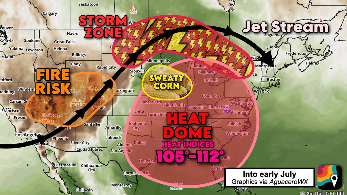
RING OF FIRE pattern really ramps up into the July 4 weekend. A bit of something for everyone. And yes, it's really called that.
The "ring of fire" gets it name because storms form a "ring" around our heat dome. Beneath the heat dome, expect extreme heat and humidity with 100-105 degree air temperatures and 110-112º+ heat index values. Combining tropical humidity with triple-digit heat isn't good. Heat advisories, watches and warnings are in effect.
The most humid air will be in Iowa and Illinois. That's where "corn sweat" season is underway. Dew points in the mid to upper 70s are fluxing an incredible amount of water into the air. As we head into the mature corn season, a single acre can "sweat" (evapotranspirate) 3,000 to 4,000 gallons of water daily! That water enters the lower atmosphere, making the humidity even worse AND leading to more storm fuel.
The heat dome is also deflecting the jet stream north. Storm complexes will form on the periphery of the warm, humid air mass and surf the jet stream southeast. Some of these storms will tap into jet stream energy and produce destructive 60-75 mph gusts. By late week, we may have to bring the storm zone south a bit.
As if that's not bad enough, we have growing fire danger over the Four Corners and Intermountain West! Rapidly-spreading fires have occurred as dry air crashes south atop gusty winds nestled in a broad jet stream dip. Relative humidities have plummeted below 10 percent in some places!
This pattern will intensify into the weekend.
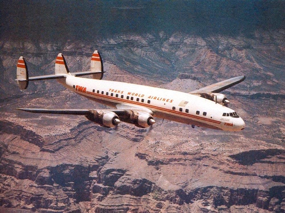
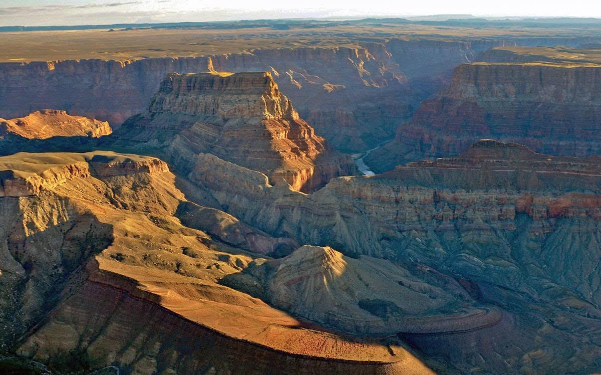
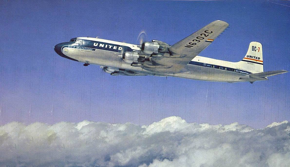
Seventy years ago, on June 30, 1956, a tragedy occurred in the skies above Grand Canyon when two aircraft, a TWA Super Constellation and a United Airlines DC-7, collided in midair. Both aircraft crashed inside the canyon and all 128 passengers and crew, from both aircraft, lost their lives. At the time, it was the deadliest civilian air disaster in American history, and bought about immense changes to air traffic regulations and infrastructure in the United States.
The aviation accident site was designated a National Historic Landmark in 2014, to preserve the stories of those who lost their lives, and to remember the significance the tragedy had on world-wide air travel.
If you're visiting Grand Canyon National Park on Tuesday, June 30, 2026, you're invited to attend the 70th Anniversary Commemoration Symposium at Shrine of the Ages Auditorium. The program will be held from 3:00 p.m. to 6:30 p.m. and is free, and open to the public. The event is sponsored by the Grand Canyon Historical Society (GCHS), the Patrons of the 1956 Grand Canyon Midair Collision, and Grand Canyon National Park,
Individual Speakers:
John Hasha - Nephew of United Air Lines Flight 718 Flight Engineer Girardo Fiore, and Secretary of GCHS.
Mike Nelson - Patrons Group President and author of We Are Going In: The Story of the 1956 Grand Canyon Midair Collision
Ian Hough, NPS - Archaeological and site work for the National Historic Landmark nomination.
Mike McComb - FAA crash investigator and aviation archaeologist
Between 6:00 and 6:30 pm, there will be a Q&A and Panel Discussion: Ian Hough, Mike McComb, Mike Nelson, and Tom Sulpizio (GCHS President and Patrons Group VP)
- Shrine of the Ages Auditorium is located within Grand Canyon Village, Near Park Headquarters, Market Plaza, and Yavapai Lodge.
Follow Grand Canyon National Park's Key Hiking Messages, with today's trail conditions, drinking water availability, weather forecast, and heat risk: https://t.co/kuz5p6M66i
What's open in the park this week - along with hours of operation: https://t.co/TU6NrXdjs5
#AZWX #GrandCanyon (10659) (81877)
News Release—Grand Canyon National Park Implements Stage 2 Fire Restrictions
Effective immediately, Grand Canyon National Park has implemented Stage 2 Fire Restrictions for the South Rim and Inner Canyon due to forecasted critical fire weather conditions.
The restriction encompasses all campgrounds, residential areas, backcountry sites, and developed recreation sites. The North Rim remains under Stage 2 Fire Restrictions that took effect on May 15, 2026.
Stage 2 fire restrictions prohibit the following:
🚫All wood burning and charcoal fires, including campfires, warming fires, and charcoal barbeques are prohibited.
🚫 Outdoor smoking, except as specifically exempted within an enclosed vehicle.
🚫 Using explosives or any incendiary device; fireworks are always prohibited on public lands.
🚫Operating internal combustion equipment capable of producing sparks, including chainsaws, weed trimmers, welders, wood splitters, generators, and similar equipment, unless authorized through the park's hot work permit process.
🚫Parking off established roadways unless the area is barren or cleared of flammable vegetation within at least three feet of the vehicle.
The following activities remain permitted under Stage 2 Fire Restrictions:
✅ Liquid petroleum gas (LPG) or propane-fueled devices that can be turned on and off, including camp stoves, lanterns, and heating devices, may be used only in an area that is barren or cleared of all flammable materials within at least three feet of the device.
✅ Generators equipped with an approved spark arrestor may be operated at park residences or developed campgrounds when used in an area cleared of flammable vegetation within at least three feet of the generator.
✅Charcoal may be ignited for cooking only along the Colorado River corridor shoreline, as provided under existing park regulations.
For the latest information on fire restrictions and current park conditions, visit https://t.co/5sshka1LAJ.
For statewide fire restriction information, visit https://t.co/Dgw0tMfJMj or call the Southwest Area Fire Restriction Information Line at 877-864-6985.
#GrandCanyon #Arizona #FireRestrictions #RedFlagWarning
Sorry, can't talk right now. I'm watching a livestream.
Summer snowmelt is sending cold, fast-moving water through rivers, streams, and waterfalls across many National Park Service sites. Every year, visitors underestimate the power of moving water, often with tragic consequences.
A few safety reminders before your next adventure 👇
New Outlook! No change to the risk areas, but added the outline of the area we're expecting the tornado risk to materialize.
Have multiple ways to receive watches and warnings this afternoon and evening! #MiddleTNwx#TNwx
Actually, one of the healthiest things a person can do is become easy to delight. Still stopping for weird clouds and dogs wearing bandanas and the smell of garlic cooking somewhere down the street.
The world already has enough cynicism. Be the person who still points at the moon.
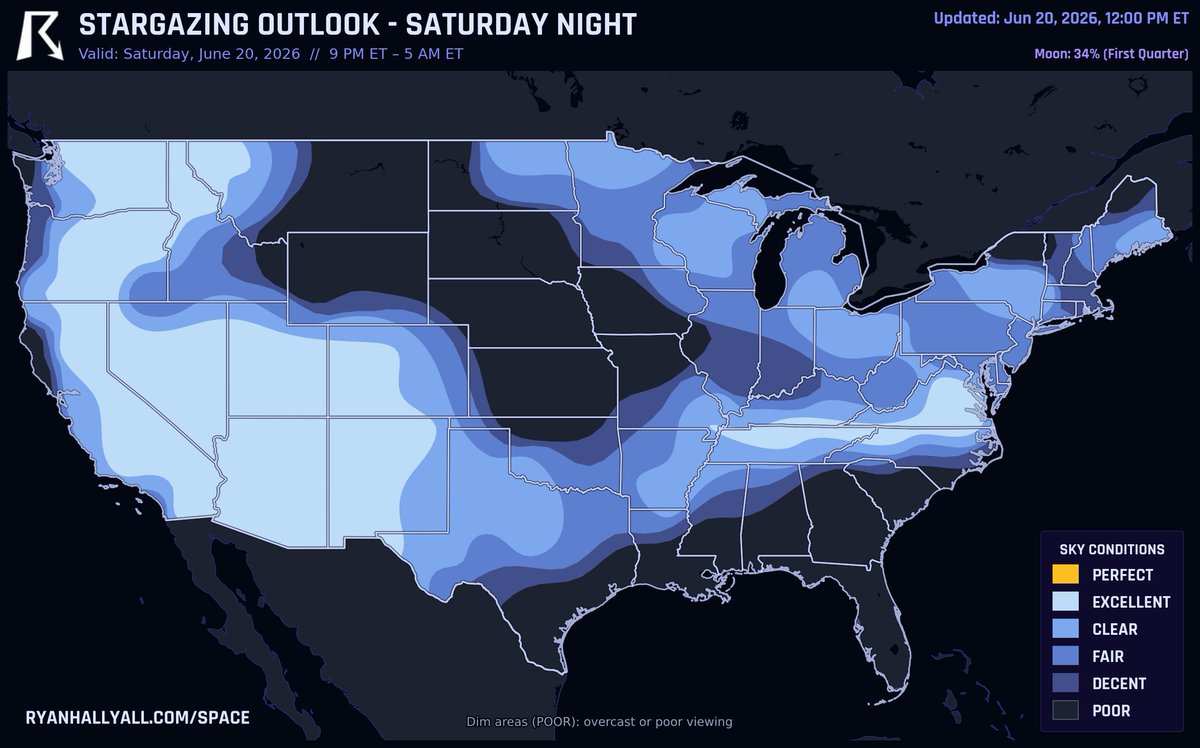
FOUR PLANETS are hanging around the sky tonight if your skies stay clear.
Right after sunset, look low to the west for bright Venus, then Jupiter below it and Mercury even lower in the northwest. If you're up before dawn, Saturn sits low in the east. Just your eyes will do, no telescope needed.
The Desert Southwest and Mid-Atlantic have the cleanest air, with spots like Phoenix, Albuquerque, and Nashville looking crisp. Keep in mind storms are the bigger story today across Wyoming, Kansas, and Nebraska, so this is for folks well away from that. The first quarter moon sets after 1 AM CT, and far north folks near the border have a faint shot at aurora low on the horizon.
Follow Grand Canyon National Park's Key Hiking Messages, with trail conditions, drinking water availability, weather forecast, and heat risk: https://t.co/kuz5p6M66i
What's open in the park this week - along with hours of operation: https://t.co/TU6NrXdjs5
#AZWX#GrandCanyon #ExtremeHeatWatch #Hiking (10127) (81279)
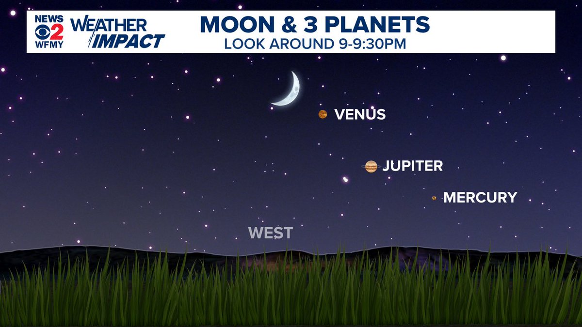
DON'T MISS IT!
You can see the crescent moon and two (or three) planets this evening.
Jupiter and Venus are easy to see to the lower right of the moon.
Mercury is a bit fainter, but still visible.
WHEN: Look around 9pm to 9:30pm
WHERE: Western sky @WFMY#ncwx
TODAY's severe risk is underway, with storm severity ramping up this afternoon. WHAT TO DO NOW:
– Understand that not everyone will see storms. Thunderstorms are scattered in nature. Some folks will see significant impacts, but most folks won't.
– Charge devices in case of power outages. Some of today's storms will be quite windy (there was already a 94 mph wind gust in Marshall County, Iowa).
– Today won't be a crazy hail day (I'm not expecting baseballs or softballs), but we could see an isolated storm produce hail bigger than limes. Perhaps consider parking under the carport.
– After about 1 p.m., plan your day so that you're near a shelter just in case. Most tornado warnings come out an average of 12 minutes in advance. If you get one, I want you to be able to quickly move to shelter.
– Please note that today's storms will move quickly! If a storm is moving at 50 mph, that means it will only start raining 11 or 12 minutes before the tornadic part of the storm arrives at your location. Things happen fast on days like today. That's why it's imperative to act on warnings as soon as you get them. Y'all know the drill!
– Know where your shelter is ahead of time: basement or interior room on the lowest floor of your home. Avoid windows. Mobile homes won't cut it on days like today.
– If you have plans to travel during the afternoon, I'd reconsider.
– Have multiple redundant ways to get weather warnings. Remember – even if we issue perfect warnings, they don't help unless you get them!
And above all, don't worry! We know it's been a LONG few weeks here in Illinois and Iowa, but – despite absolute swarms of tornadoes – there have been no fatalities. Why? Because y'all ROCK when it comes to severe weather. You know this stuff! Let's keep the streak up by putting into action all the stuff we've practiced.
We'll be here for the entire event with you every step of the way.
Central Illinois faces a rare Level 4 out of 5 severe weather risk this Wednesday, with threats extending into Indiana. Prepare for potential EF3+ tornadoes, 80 mph winds, and massive hail. Storms will move fast, so charge your phones and know your safe space immediately.
UPDATE on tornado risk WEDNESDAY, June 17:
Illinois and Indiana should be prepared for the potential for a serious severe weather outbreak. Several tornadoes, including a few strong and/or long track, are possible where supercells occur. Elsewhere, squall line(s) may bring damaging gusts of 65-75+ mph.
The zone of greatest concern is along and south of a warm front that will be lifting north throughout the day. It will position just south of Chicago to Valparaiso.
The morning will feature scattered early-day downpours and thunderstorms as the warm front approaches. A few storms may produce hail and wind. That's just the appetizer.
The warm front's arrival will introduce an exceptionally warm, humid air mass – especially if skies clear behind the morning storms and allow sunshine to further heat the ground.
That's around the time that a potent jet stream dip will scream overhead, adding robust wind energy to the equation. There will be an incredible amount of wind shear, or changing winds with height. Any storms that grow tall enough to feel those changing winds will rotate.
Furthermore, the warm front will enhance low-level helicity, or spin, boosting the tornado risk.
OUR GUT: we think we'll just have 2 or 3 dominant, longer-track supercells. They'll produce the bulk of the severe weather across the corridors along which they propagate. The greatest risk will be a west-to-east zone along the warm front, especially if morning thunderstorms can sort of sharpen/reinforce that front.
Only about 10-20 percent of folks will be impacted by supercells, but the ceiling is there for an upper-echelon event and some EF3+ tornadoes.
Elsewhere, a squall line evolving along the cold front will produce sporadic damaging straight-line gusts and a few tornadoes.
The nicest weather in the USA today is split between Portland, OR, Nashville, TN, and Baltimore, MD.
High pressure has dry, comfortable air and light winds in all three for a Beautiful day. Most of the country lands Decent to Fair, just watch IL and IN for a strong storm risk. Coffee outside, dinner outside.
Introducing Artemis III.
Four astronauts. Three launches. Two dockings. One splashdown.
In 2027, the Artemis III mission will practice docking the Orion spacecraft with two lunar landers in low Earth orbit — the capability we need to return humanity to the Moon’s surface.
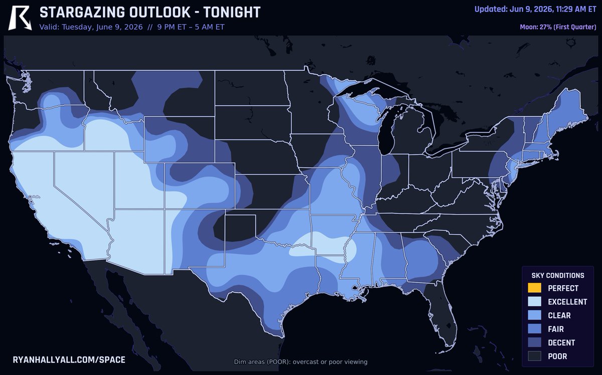
FOUR PLANETS are up tonight if your skies stay clear!
Right after sunset, look low to the west for Venus and Jupiter, with Mercury hanging out lower in the northwest. Then if you're up before dawn, Saturn shows up low in the east. Just your eyes will do.
The Desert Southwest and Great Basin have the cleanest air for it. The Midwest, Great Lakes, and Northeast are fighting clouds, storms, and fog tonight, so your odds there aren't great.