El Nino has reached territory we've never seen before...
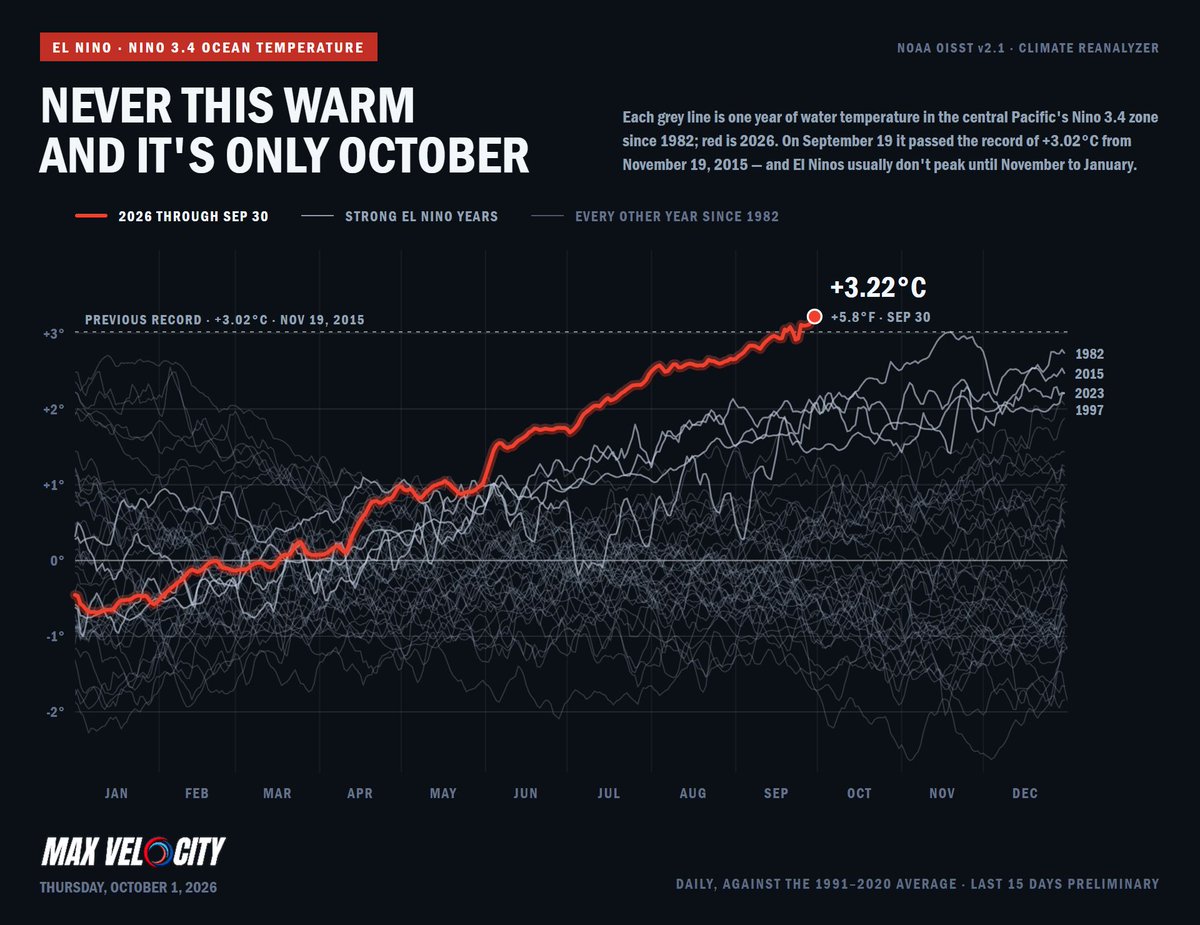
The Niño 3.4 region, an area of the tropical Pacific Ocean between roughly 120°W and 170°W, has reached an incredible +3.22°C above average, the warmest value ever recorded there.
This region is especially important because it is one of the primary areas scientists use to measure the strength of El Niño and La Niña. When the waters here become unusually warm, it can have major effects on atmospheric circulation and weather patterns across the globe.
That +3.22°C value has already surpassed the previous record of +3.02°C set in 2015, and we're only entering October.
Even more remarkable, El Niño events typically don't peak until November through January, meaning this event is already at unprecedented levels well before its climatological peak.
This El Niño is entering truly historic territory.
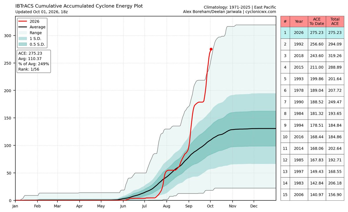
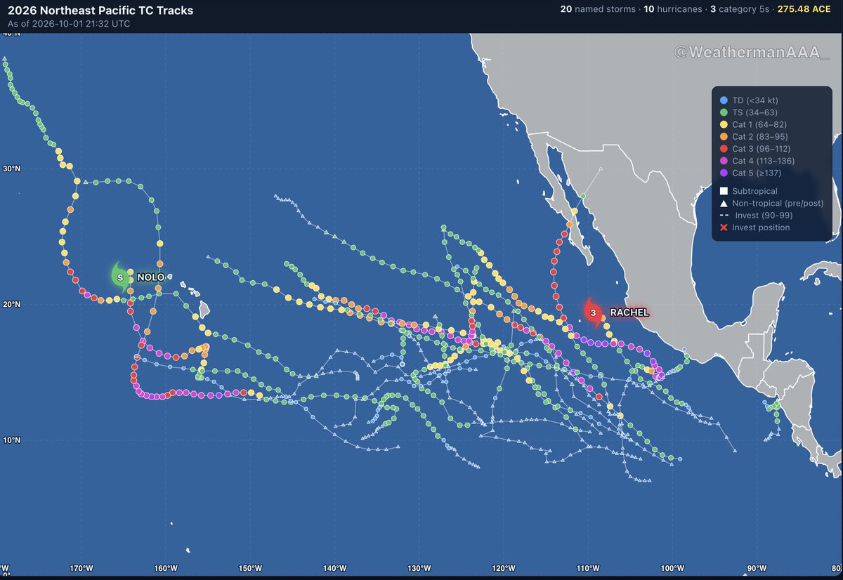
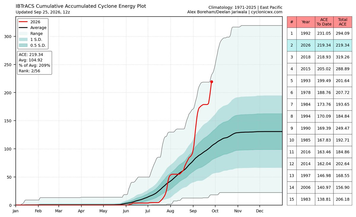
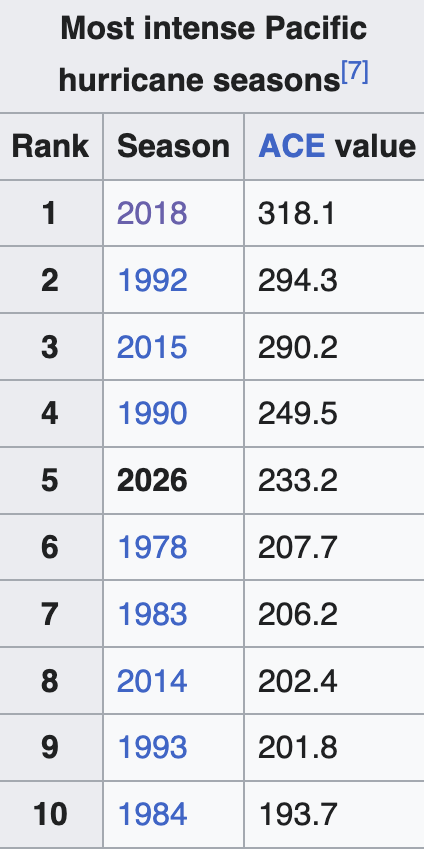
This is honestly what a generational east Pacific season looks like. With additional activity expected through October, 300+ ace is looking more and more plausible
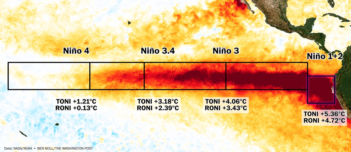
The Niño 1+2 region, near Peru and Ecuador, has reached a remarkable 5.36°C above average — about 0.7°C higher than the previous record from 1983.
It is breaking records in both the traditional and relative sense, and is forecast to approach 6°C above average during November.
THIS IS WILD! Hurricane Nolo has the "stadium effect" and mesovortices, and is nearly a Category 5 Hurricane about 350 miles Southwest of Hawaii...
@WxFront
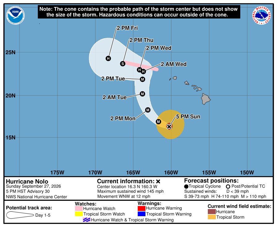
Hurricane #Nolo is now expected to reach Category 5 status southwest of Hawaiʻi, making it the 4th category 5 of the year in the Eastern/Central basin.
This would be the new record for most category 5 hurricanes in a season, passing 1994, 2002 and 2018.
Fun fact: according to this chart, the EPAC has produced the ACE equivalent of a hyperactive Atlantic hurricane season (160) within the last 30 days alone.
New additions to PolarWx:
- You can now save satellite, radar & recon animations
- Lat/lon coordinate readouts on hover
- Satellite IR brightness temp readouts
- Archived radar available for select storms
https://t.co/hx2aMBrtm9
An example saved loop of Hurricane Irma (2017):
This was about as good as Hurricane Nolo looked today… for a few hours this morning it had a fully enclosed eye but by our last pass it the entire north side was open. The latest forecast from NHC still has it becoming a major but going further west and away from the islands.
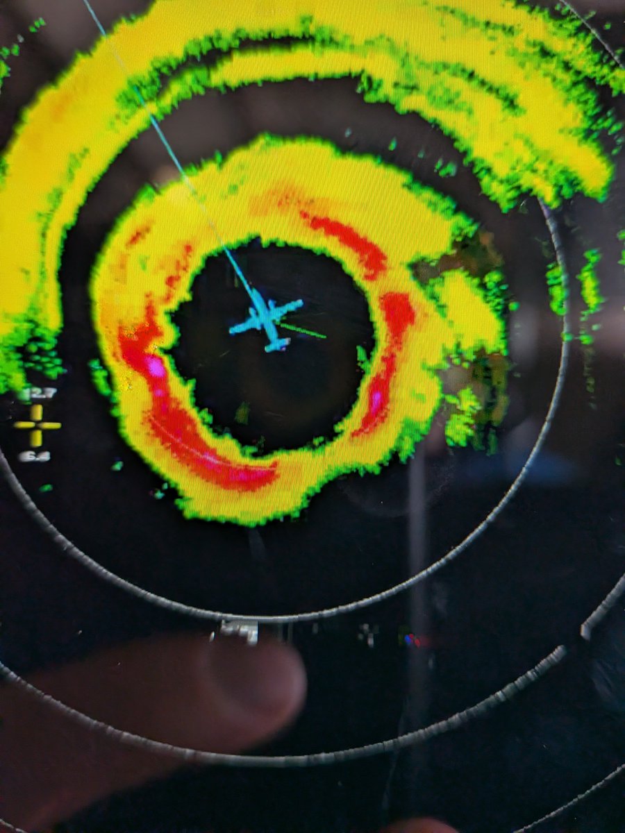
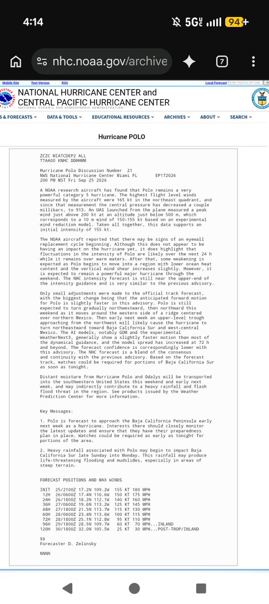
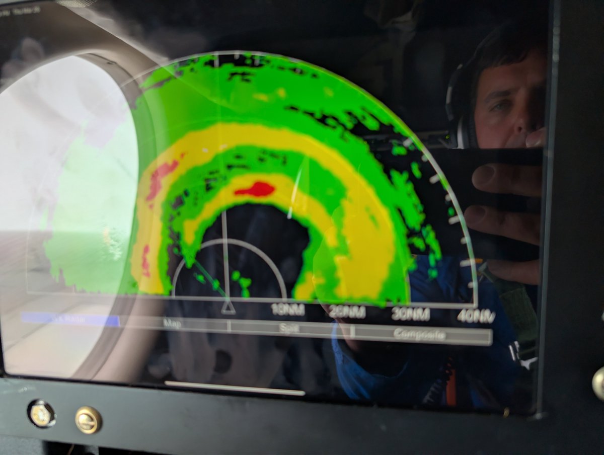
A couple of the images from #hurricane#Polo on yesterday's mission from N42. We deployed 4 @BlackSwiftTech S0 UAS into various parts of the storm. NHC quoted the data we used in their forecast discussion which is pretty cool. Almost a 9.5 hr mission. It was busy
Into the eye. 🌀✈️
The Air Force Reserve #HurricaneHunters fly through Hurricane Nolo, collecting critical atmospheric data that helps @NHC_Atlantic forecasters better determine the storm’s location, intensity and structure.
#53WRS#403rdWing#AirForceReserve
Drones just flew into the most dangerous part of Category 5 Hurricane Polo! 😲
One of my former college professors, Dr. Wadler, flew directly into Polo today to help deploy drones designed to explore areas of hurricanes that are too dangerous for humans and research aircraft to enter.
It’s incredible to see this technology being used to gather data from one of the most powerful storms on Earth, and even cooler to see someone who taught me playing a role in it!
@JoshWadler
Wow, just wow. The 2026 Pacific hurricane season east of the IDL is now ranked #2 & not far from surpassing 1992. Now I want to be clear that this does not mean we will surpass 300 ACE points, but the fact is that we might pass 1992 in ACE points at this rate on a given day due to 3 hurricanes churning at the same time, with 2 of them now being major. With Nolo forecasted to become a major in a few days, it would not shock me if we get to 300 ACE in the next week or two.
Fun fact: We have been accumulating around 10-15 ACE points per day since September 21st.
Running the calculations shows that we should reach 300 ACE in about 8-12 days (October 2-6) and break the all-time record by October 10th due to a 90% AOI in the EPAC that looks to become a hurricane in the next 5-8 days.
The much talked about nor'easter is now well underway, with a large cyclone producing widespread rain and significant coastal flooding slowly making its way north.
Slightly technical thread discussing its structure and forecast: 🧵
Incredible loop of Hurricane #Polo this week.
Intensifying from a Tropical Storm to a Category 5 hurricane in just 24 hours, the storm then proceeded to peak as the 2nd most intense eastern Pacific hurricane on record (892mb).
That was quite a flight into #Polo. With the ERC finishing it started to ramp up towards the end and we got a lot of side to side motion that made me queasier than I usually am. Should be an awesome dataset for understanding eyewall replacement cycles!
Three hurricanes in the Pacific: the fingerprints of a record-strong El Niño.
Nolo will lurk south of Hawaii. Odalys could bring some heavy rain to Southern California Sunday-Monday. Polo might flood parts of Arizona, New Mexico, Colorado, Kansas, Oklahoma and Texas next week.