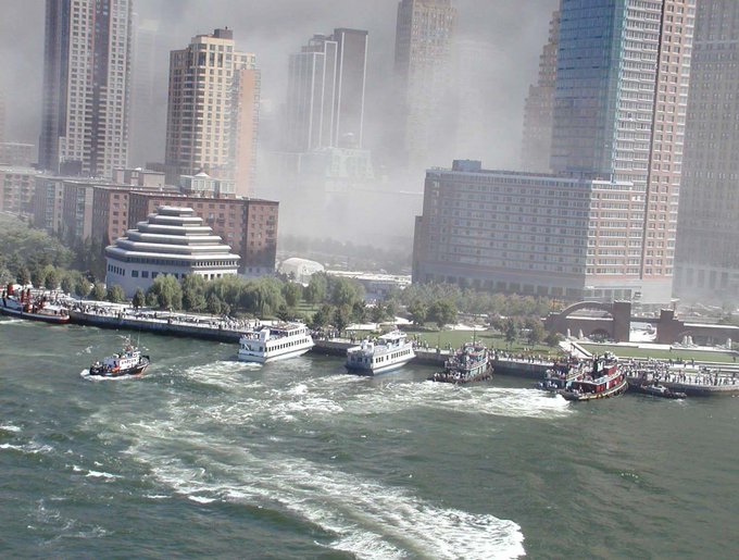
Immediately following the initial attacks on the World Trade Center, tunnels were closed, and traffic fleeing Manhattan via bridges reached a standstill.
Many civilians, especially in those neighborhoods closest to the attacks, were desperate to escape the island but had no way to do so.
Luckily, their salvation came like lightning.
A coast guard transmission went out. “All available boats,” it said.
“This is the United States Coast Guard… Anyone wanting to help with the evacuation of Lower Manhattan report to Governors Island.”
Within minutes, around 150 private ships of all shapes, sizes, and purposes reported for duty and got to work.
All told, these heroic captains transported around 500,000 people away from the disaster zone.
This came to be known as the 9/11 Boat Lift, which to this day, is the largest water evacuation in history.
Additional Aurora sightings (weather permitting) may be possible this evening into tomorrow! A Geomagnetic Storm Watch has been issued for Sunday, May 12th. Periods of G4-G5 geomagnetic storms are likely! 👀
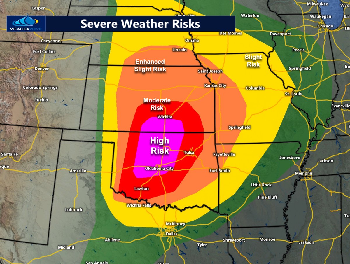
A rare HIGH RISK, a level 5 out of 5 risk, has been issued by the Storm Prediction Center. Long track strong tornadoes are possible near this region. Kansas City is in the level 3 out of 5 risk. Let's monitor this dangerous day closely.
We've been fielding some questions this morning on what the threat levels mean so here is the reference. Some additional interesting info...we average less than one moderate per year somewhere in our forecast area. Our last high risk day was in 2008! (and let's keep it that way)
Just another friendly reminder that strong to severe storms are possible again tonight, primarily in the 11 pm to 3 am window. Large hail will be the main threat. Another round of storms is likely tomorrow morning, and these also could be strong to marginally severe.
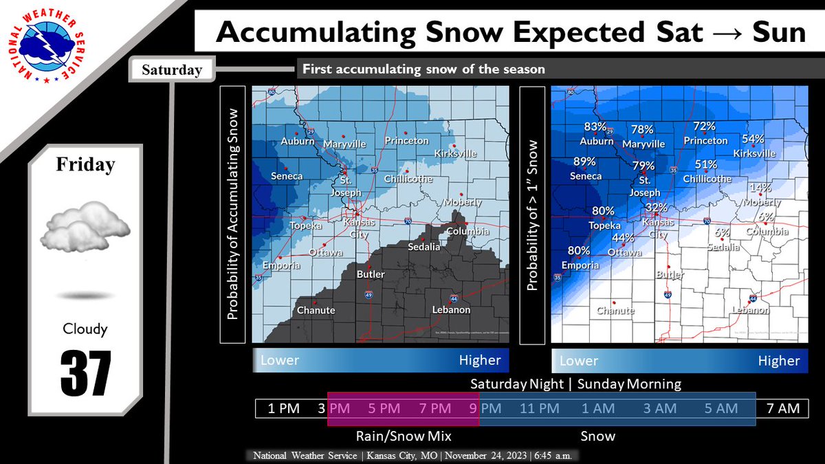
Confidence is increasing in snow blanketing portions of the region Saturday into Sunday. As seems normal, the transition zone between rain & snow looks to set up near the I-70 corridor & could significantly affect snow totals across the KC Metro. Stay tuned for forecast updates.
The Winter Outlook was released by CPC yesterday. There is a slight lean for above normal temps & precip for the local area. Historically, a El Nino winter (particularly a strong one) favors above normal temps, a slight lean to below normal precip and less than normal snow.
Remember how you found your way to church over the summer, when the Grand Mere Parkway traffic circle was closed? Well, it is time to dig out those memories. The city has changed the closure dates for the temporary road to Oct 4-13.
Don’t let that “detour” you from coming!
Join us Wednesday, Oct. 4, 6-8 p.m. at the Konza Prairie Nature Trail start for a special Prairie Poetry Pop-up walk! We'll talk about poetry and the natural history of the our Flint Hills home.
A reminder of SRO Gregoire's message for the school year - Please stop for school buses!
Getting to work 30 seconds faster and risking children's safety - $413
Waiting for children to get on and off the bus safely - Priceless.
Please stop for school buses!
🧵
All Disciple congregations are invited to join the national launch of One Home One Future, a multi-faith campaign to strengthen connection across generations for creation care in congregations nationwide https://t.co/xip7mdOROA #OneHomeOneFuture
Folks, these conditions are untenable for even short durations.
These types of conditions will continue through at least Wednesday, perhaps into Thursday.
As much as possible, limit outdoor exposure for the upcoming week.
Friendly back to school reminder:
When kids show up late for school, they still showed up. Thank them, not scold them. It’s not always their fault.
“I’m happy you’re here” goes a very long way.