The answer you need probably isn’t in one dataset.
SynMax brings together field activity, market signals, infrastructure, reported data, and your own information — all searchable in plain language.
Ask. Build. Decide.
See it in action at #SuperDUG in Houston. Booth 617.
#Upstream #OilAndGas #EnergyData
At sea, the threats that matter go dark to disappear. SynMax Theia finds them from the imagery itself. Now, as exclusive maritime partner for @Satellogic's Merlin constellation, it does so across far more of the ocean, near-daily. See the Truth. Seize the Edge.
https://t.co/aXPOwU6hNX
@bashfulpav@hayasaka_aryan I agree with you. Truly a sad state of affairs. I hope and pray Elon Musk has very very good security because you know these wacko leftists will try to get him
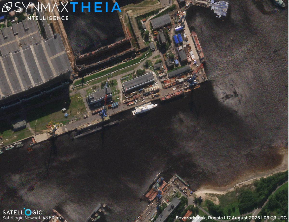
UPDATE: Following our previous post on the KOSATKA's (IMO 1011551) arrival at Severomorsk, Russia (link in comments), SynMax's maritime domain awareness platform, Theia, has identified Putin’s yacht alongside Severodvinsk.
The KOSATKA's last detection at Severomorsk was on the 7th of August. She was identified at Severodvinsk on the 17th, approximately 350km to the southwest.
The 82-meter superyacht, formerly named GRACEFUL, is widely linked to Russian President Vladimir Putin and was sanctioned by the United States in 2022, shortly after which she was renamed. She had not transmitted on AIS since 2022, before briefly reappearing last June, when she departed the Baltic Sea under naval escort, reportedly bound for the Arctic amid concerns of Ukrainian long-range drones.
Severodvinsk is home to the Sevmash shipyard, where the KOSATKA's hull was originally laid down.
Theia ingests more than 40 million km² of satellite imagery daily, fusing EO, SAR, and AIS data to automatically detect, identify, and track tens of thousands of vessels across oceans, regardless of AIS status. SynMax's Agentic AI, Atlas, provides automatic alerts on vessels of interest, delivering actionable intelligence on high-value targets.
Tomorrow, SynMax joins Crue Club in Denver for The Next Evolution in Unconventionals, led by Jon Holt of Black Mountain Oil & Gas.
Tier II/III rock, EOR/IOR, refracs and infills all raise a bigger question: where does the next opportunity come from?
That’s the kind of challenge we’re building BasinIQ around to help operators investigate.
See you in Denver.
#BasinIQ #OilAndGas #Upstream
We’re thrilled to be attending the 13th Annual Maritime Security West conference in San Diego this week!
You can find us at Booth 9, where we are showcasing SynMax's maritime domain awareness platform, Theia, which fuses more than 40 million km² of daily satellite imagery with global AIS, synthetic aperture radar (SAR), and additional intelligence sources to detect, attribute, and track tens of thousands of vessels across the world's oceans.
Automatic AIS spoofing detection, dark vessel attribution, and ship-to-ship transfer identification are just three of the ways Theia provides the ground truth that maritime security, law enforcement, and defense decision-makers require.
Working alongside Theia is Atlas, SynMax's Agentic AI, which directly interrogates Theia's vast pre-processed, auditable datasets to automate routine investigations and highlight items and areas of interest.
If you’re attending, please stop by to see Theia and Atlas in action, or send a message to arrange a meeting. We look forward to seeing you in San Diego!
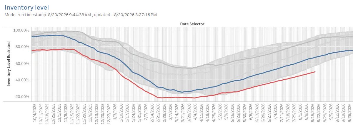
39% of U.S. data-center capacity planned for 2027 — about 14.1 GW — hasn’t cleared land.
If silicon keeps refreshing faster than the grid comes online, what happens to the GPUs waiting for power?
That’s the question behind our forthcoming white paper.
⚡Read the latest Vulcan report for a preview:
https://t.co/oz4jldZii4
#DataCenters #AIInfrastructure #PowerMarketsResearch
At SynMax, we are tracking the maritime industry's growing adoption of wind-assisted propulsion, this time turning to the Ultramax bulk carrier MARIA TOPIC (IMO 9726267), which was recently fitted with a rigid wingsail.
The 10-year-old, 199m bulker was retrofitted with a tiltable rigid wingsail from French company OceanWings, the system's first installation on a bulker, alongside a suite of solar panels. Theia imaged the MARIA TOPIC on the 20th of June 2026, before her wingsail was fitted, and again on the 19th of August, now clearly showing the wingsail on deck. She is currently sailing across the Pacific on sea trials to test energy production, fuel savings, and the practicality of the new technologies.
The retrofit was carried out under the EU-funded WHISPER (Wind Energy Harvesting for Ship Propulsion Assistance and Power) project. WHISPER aims to demonstrate fuel savings of approximately 30 percent on a retrofitted bulk carrier, with the results of the sea trial intended to understand the technology's wider potential across the existing fleet.
SynMax's maritime domain awareness platform, Theia, fuses more than 40 million km² of daily satellite imagery with global AIS and additional datasets to automatically detect, identify, and track tens of thousands of vessels across oceans.
After joining Crüe Club in Midland on August 25th, SynMax will be back at the table on August 27th for the Operator Roundtable in Oklahoma City.
These conversations are a chance to stay close to the people using data to make real upstream decisions, and it’s one of the ways we make sure what we build reflects the needs of the teams using it. 🤝
#CrueClub #OilAndGas #Upstream #SynMaxIntelligence #EnergyIntelligence
Two new Vulcan tools are live:
🟢 Project Evaluator — search any project, get an instant read.
🔴 Change Monitor — see what changed over 7, 30, or 90 days.
Read the full report to see them in action.
↪ https://t.co/NUzEEI0lxt
#DataCenters#VulcanResearch#ERCOT
In the third part of our spoofing series (find parts one and two in the comments), we look beneath AIS entirely, to the satellite navigation signal it depends on.
AIS spoofing, covered in Part 2, involves a vessel transmitting false data of its own accord. Global Navigation Satellite System (GNSS) spoofing, sometimes called GPS spoofing, is a different attack altogether. Rather than a vessel choosing to lie, an external actor counterfeits the satellite positioning signal that the vessel's equipment relies upon.
Because AIS generally broadcasts the position supplied by the vessel's GNSS receiver, if the receiver's position solution is corrupted, every downstream system inherits the same error. The vessel's onboard systems, and consequently its AIS broadcast, report a position that is not true, often without the crew being aware that anything is wrong. Unlike AIS spoofing, where a vessel deliberately misrepresents itself, GNSS spoofing can render an unwitting vessel, and everyone tracking it, briefly blind to the truth.
GNSS spoofing and jamming are both forms of radio-frequency (RF) or electromagnetic interference (EMI) that exploit weaknesses in satellite navigation signals. Jamming overwhelms the GNSS signal with noise, preventing a receiver from obtaining a position. Spoofing is a more sophisticated application of the same vulnerability. Rather than drowning out the genuine signal, a spoofing source broadcasts a counterfeit version that is stronger or more convincing than the authentic transmission. Critically, many conventional GNSS receivers have little or no ability to distinguish counterfeit signals from genuine ones. Where jamming can produce an obvious gap, spoofing produces a confident, continuous, and entirely wrong answer.
The effect can be dramatic. Ships have appeared, according to their own instruments, to be circling in fields, stranded miles inland, or clustered at a single point in open water, positions with no physical basis, produced entirely by a corrupted signal. GNSS spoofing has been increasingly observed in contested regions, including the Black Sea, the Baltic Sea, the Red Sea, and the Persian Gulf, where it is employed to degrade the effectiveness of GPS-guided munitions and drones. The resulting disorder to civilian shipping is, in most cases, collateral damage.
The accompanying graphic illustrates this effect in the Persian Gulf, where Theia identified numerous AIS tracks whose reported positions had been displaced to fixed inland locations.
The implications extend well beyond AIS accuracy. GNSS underpins navigation, timing, and safety systems across the maritime domain. When the signal itself cannot be trusted, verification cannot rely on any instrument that consumes it, however sophisticated.
For the purposes of maritime domain awareness (MDA), satellite imagery provides an independent source of positional truth independent of GNSS reception or vessel transmissions. SynMax's MDA platform, Theia, detects and identifies vessels directly from satellite imagery, fusing more than 40 million km² of daily imagery with global AIS and additional intelligence sources to establish a position independent of any signal that can be jammed, corrupted, or counterfeited.
Next week, SynMax’s Amii Rozell will be at the Crue Club Operator Roundtable in Midland.
The August 25 session will focus on Extended Laterals, facilitated by ConocoPhillips.
We’re looking forward to hearing directly from operators about the challenges they’re facing and joining the discussion once again. 💚
#CrueClub #PermianBasin #Upstream
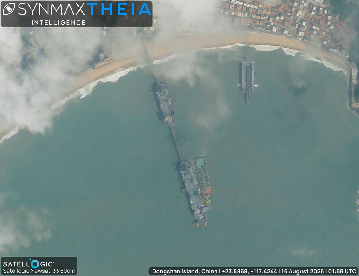
UPDATE: SynMax's maritime domain awareness platform, Theia, continues to monitor China's growing fleet of Shuiqiao-class Landing Platform Utilities (LPUs), or self-propelled jack-up barges.
Following our previous coverage (link in comments), yesterday, Theia tasked further Satellogic high-resolution imagery, which clearly shows a vessel alongside one of the eight-legged Shuiqiao-class platforms off Dongshan Island, China. The vessel's ramp is connected to the LPU's ramp, and she appears to have vehicles on deck.
The vessel is assessed as very likely the BO MAO (MMSI 413244720). Prior to this, the BO MAO had reported alongside Berth No. 5 at Haitian Container Terminal, Xiamen, on the 15th of August. Following the observed connection with the LPU, she transited to Shanwei, China.
Ingesting more than 40 million km² of satellite imagery daily, Theia fuses electro-optical imagery with global AIS to automatically detect, identify, and track tens of thousands of vessels, establishing patterns of life against which unusual activity clearly stands out.
Since our last report on China’s Shuiqiao-class Landing Platform Utility (LPU) barges, SynMax’s maritime domain awareness platform, Theia, has continued to monitor the movement and deployment of these strategic PLA Navy vessels.
On the 2nd of August, 2026, Theia detected the barges departing from their home port at Yuhuan Island, China. The following day, they were detected transiting southwest through the Taiwan Strait.
By the 5th of August, Theia had sighted the barges at Dongshan Island in their current configuration. On the 11th of August, Theia tasked high-resolution @Satellogic imagery of the deployment.
The exercise forms part of an increase in military activity in the area, including a hospital ship positioned south of the barges’ deployment area, which has been present since at least the 7th August.
The Shuiqiao-class LPUs are self-propelled jack-up barges equipped with retractable legs and extendable roadways, allowing them to establish artificial docking facilities in areas without conventional port infrastructure. Their potential role in an amphibious operation makes them strategically important for moving military supplies from mainland China to Taiwan in the event of an invasion.
Theia ingests and automatically analyzes 40 million km² of satellite imagery daily, while SynMax’s agentic AI, Atlas, monitors strategic assets and provides automatic alerts when a change is detected. With Theia’s tip-and-cue capabilities, analysts can maintain awareness of strategic maritime assets and direct higher-resolution collection as activity evolves.
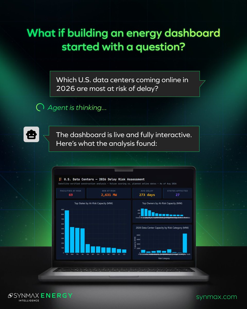
From one question to a fully-informed dashboard you can customize and refine.
Agents Dashboards turns your question into an AI-driven dashboard with charts, maps, tables, KPIs, and more.
Drag. Drop. Filter. Adjust. Ask another question and watch it evolve.
⤷ https://t.co/oEnZMttKMg
#AI #EnergyIntelligence #DataVisualization
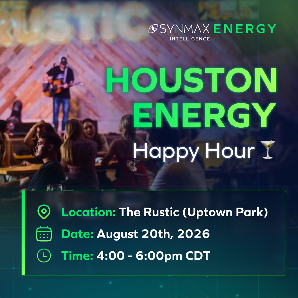
Houston, we’re one week out! 🍸
Join SynMax on Thursday, August 20th, at The Rustic in Uptown Park for a casual meetup with Houston’s energy community. Let us know you'll be there by RSVPing below! ⬇️
RSVP: https://t.co/c3GmWinVQq
#HoustonEnergy#HTXEvents