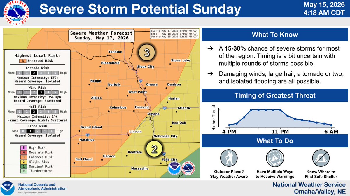
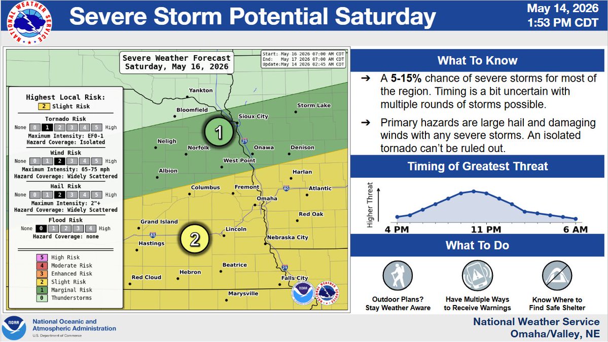
Whether you're celebrating a grad, the end of the school, or arrival of spring, this will be a weekend to pay attention to the forecast.
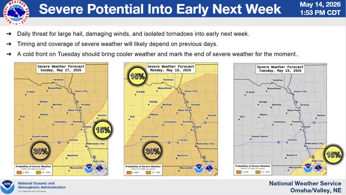
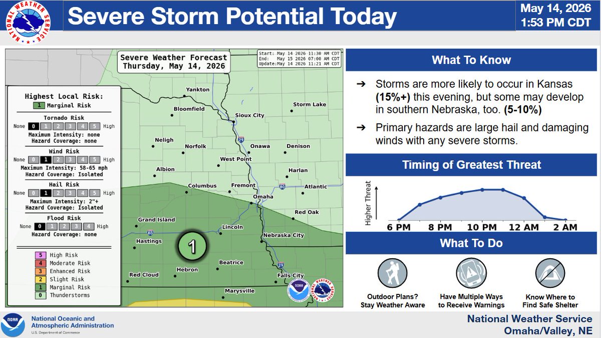
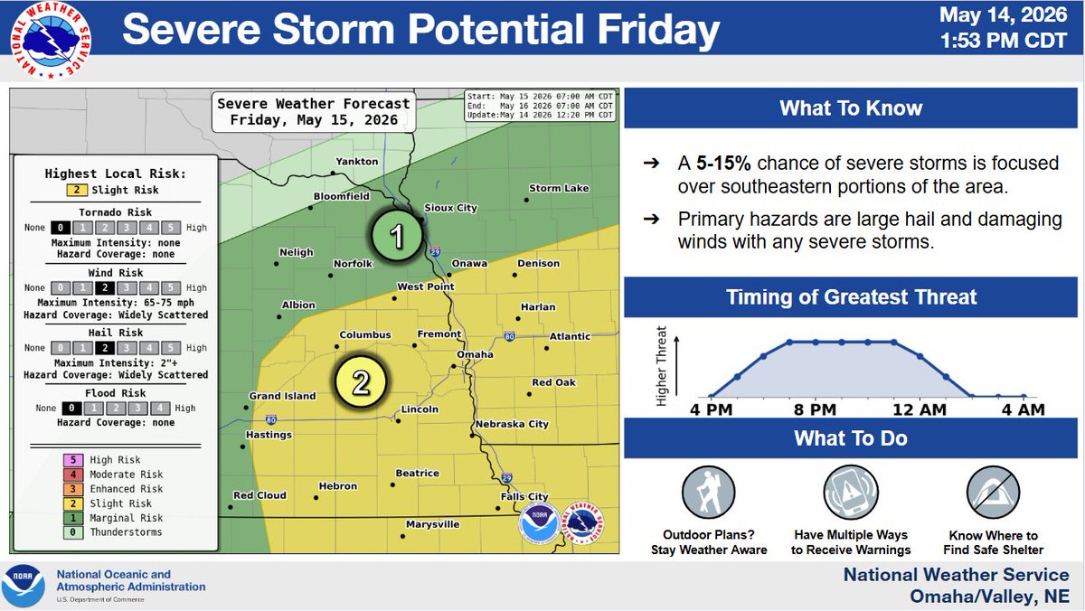
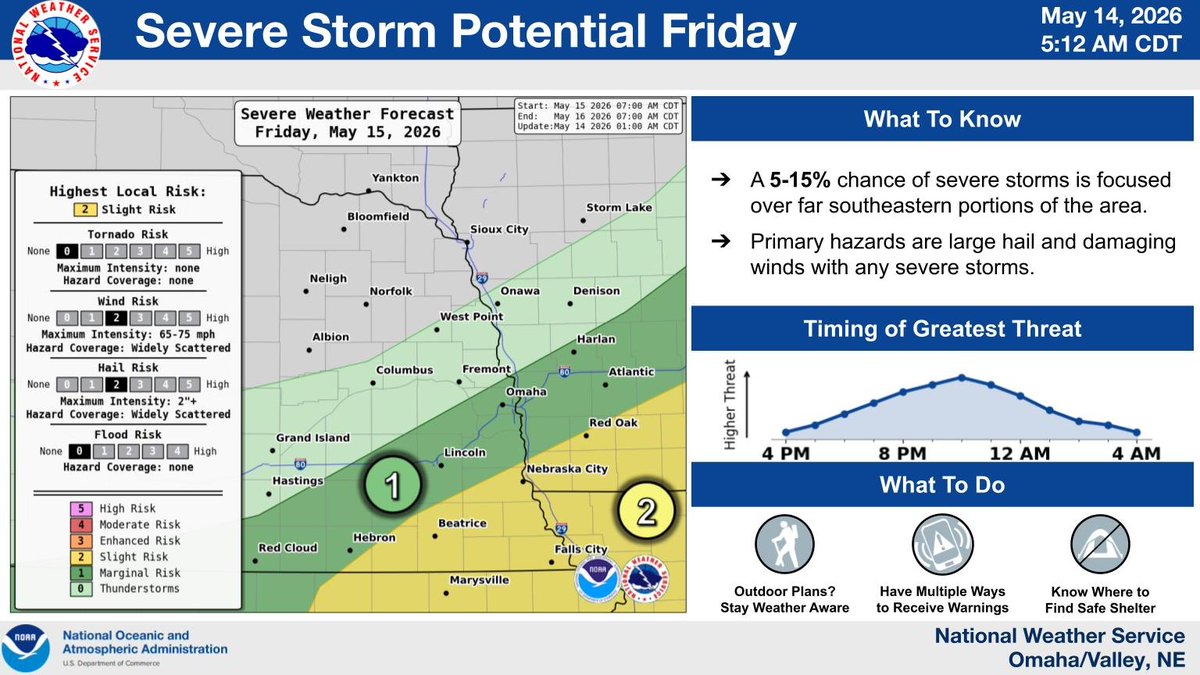
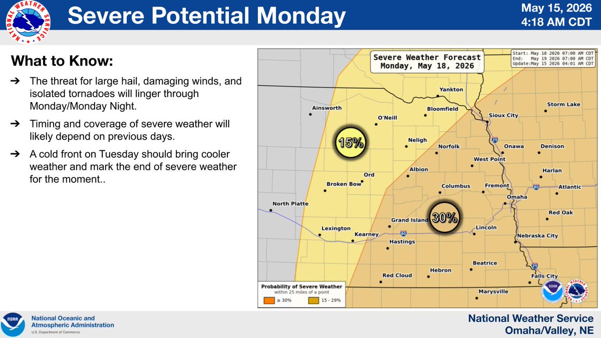
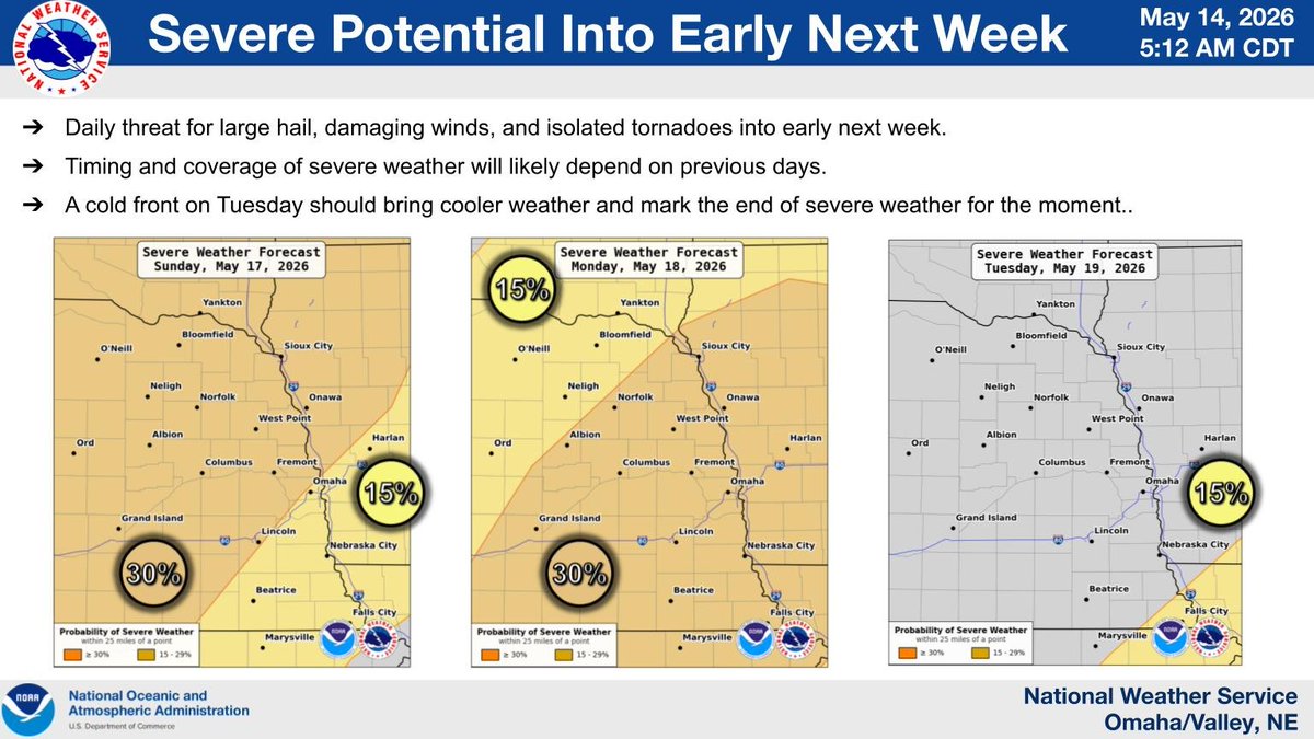
Multiple rounds of strong to severe storms are on track to affect the area, with each day having new wrinkles that could ruin outdoor plans.
Nebraska/Iowa...Now is the time to be weather aware as several days of severe weather will be possible across the area through early next week. Have multiple ways of receiving warnings. #newx#iawx
An active period of weather continues through this weekend into early next week. Daily chances of severe weather are expected, with multiple rounds of storms possible, especially during the afternoon and evening. Now is the time to prepare if you have plans this weekend.
Unseasonably cool weather across the Plains and into the Midwest today will push even further south and east behind a cold front as we move into Saturday. Above normal readings are set to return to much those same areas by mid-week next week. Check out the latest in your neck of the woods at https://t.co/qk3BcVP5M8.
Did you know that the NWS deploys meteorologists to wildfires? Incident Meteorologists depart the comfort of an office to set up camp at incident command posts where they provide forecasts to keep firefighters prepared for upcoming weather. There are currently (as of September 4, 2025) 20 meteorologists deployed across the western U.S.
📸Incident meteorologists and fire officials at the Bison Ridge Fire in Idaho. NWS Photos: Robert Hyatt
https://t.co/E2IuTIE5nZ
Looking at visible satellite this afternoon, here's what stands out:
🌀Hurricane Erin swirling off the Atlantic Coast
⛅️Expansive cumulus fields across the Midwest and Southeast
🌦️Band of clouds with showers associated with a cold front from Utah to North Dakota
🔥Smoke from wildfires burning in Idaho
☀️Clear skies (and hot temperatures) across the West
@NOAASatellites
Even with today's beautiful-looking beach weather for much of the coast from South Carolina to Florida, Erin is creating some potential dangers beneath the waves.
It looks safe…until it’s not. Strong rip currents can pull you out in seconds. Follow advice from lifeguards, local authorities, and beach warning flags.
https://t.co/h4VT4Beoid
📷Image: Map of the combined rip current risk August 21-22.
Storm surge flooding and tropical storm conditions are expected in the North Carolina Outer Banks beginning late Wednesday or Wednesday night, where Tropical Storm and Storm Surge Warnings are now in effect. The storm surge will be accompanied by large waves, leading to significant beach erosion and overwash, making some roads impassible. Visit https://t.co/e2VkdavDM2 for the latest.
Last night, the 53rd Weather Reconnaissance Squadron flew into the eye of Hurricane Erin—and captured imagery of the breathtaking stadium effect.
These missions provide critical data to the NHC to improve forecasts, helping keep communities safe before the storm makes landfall.#readynow #weatherready
The Dragon Bravo Fire, ignited by a lightning strike on July 4, 2025, on the North Rim of Grand Canyon National Park in Arizona. As of August 11 the blaze has burned more than 143,000 acres and reached 44% containment as firefighting efforts continue.
Forecasters are tracking a number of tropical disturbances in the Atlantic and Pacific, and it's important you stay ready with hurricane season ramping up. Meet Commander Kevin Doremus, who flies into storms with the NOAA, P-3 Orion Hurricane Hunter. His team has a plan - do you? Start today! #HurricanePrep
Today marks the 5-year anniversary of the August 10, 2020 Corn Belt Derecho -- the costliest thunderstorm event in U.S. history. The derecho was responsible for widespread wind damage from eastern Nebraska through northern & central Indiana and produced several tornadoes as well.
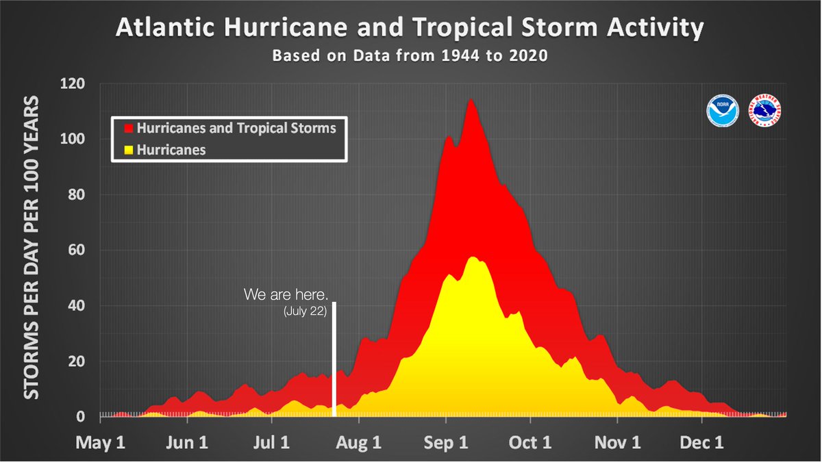
ICYMI: The updated NOAA Atlantic Hurricane Season outlook is that the May prediction remains on track for above-normal Atlantic hurricane season. On average, nearly 80% of all named storms in the Atlantic occur after August 14, so we have a long way to go. Prepare now. https://t.co/W1lAEpNht7
NWS is hiring! The first of several top-priority, mission-critical positions posted Friday on https://t.co/Qk2xhJcsda!
Others will follow soon. Visit https://t.co/Qk2xhJcsda and search “NWS” to learn more.
Clouds are science in action! Interested in learning more about weather and the science behind it? Visit Jetstream, the NWS online weather school! https://t.co/hF1EHHNNi5
🚨 Downbursts Decoded?
We're testing a new radar technique to give forecasters earlier warning of damaging winds from downbursts 🌩️💨
A new radar algorithm = better storm triage ⚡
LEARN MORE 🎥🔗: https://t.co/HR3DISGbtQ
On average, 86% of all named tropical systems in the Atlantic occur after August 2, and the first hurricane doesn't form until August 11.
We have a long season to go. Prepare now, and learn more about how at https://t.co/bvYB4en5D2