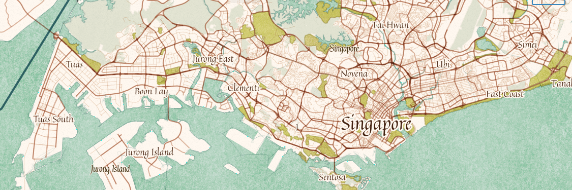
GeoLibre v0.5.0 is out! This update significantly expands data format support, making it easier to work with a wide range of geospatial datasets in a lightweight, modern GIS environment.
Newly supported formats and services include: GeoJSON, Shapefile, GeoPackage, GeoParquet, KML/KMZ, FlatGeobuf, PMTiles MBTiles, GeoTIFF, Zarr, LiDAR point clouds, Gaussian Splatting, and ArcGIS services.
GeoLibre is a lightweight, cloud-native GIS built with MapLibre and Tauri. It runs directly in the browser and is also available as a standalone cross-platform desktop application at only ~30 MB.
GitHub: https://t.co/VXq8c1oACL
Website: https://t.co/7VA2AQpaJK
Live demo: https://t.co/Cq5Mg3oRDo
Feedback, ideas, and contributions are welcome.
#geospatial #opensource #maplibre
I'm excited to introduce GeoLibre, a lightweight, cloud-native desktop GIS built with MapLibre GL JS and Tauri.
GeoLibre is designed for modern geospatial workflows, combining the flexibility of web technologies with the performance of a native desktop application. The current prototype includes a MapLibre-powered map workspace, local vector data import, project persistence, and built-in plugins for basemaps, layer control, swipe, street view, lidar, GeoAgent, and GeoEditor integrations.
GeoLibre can run directly in a web browser or as a standalone cross-platform desktop application (<30 MB).
GitHub: https://t.co/VXq8c1o2Nd
Website: https://t.co/7VA2AQoCUc
Live demo: https://t.co/Cq5Mg3ojNQ
Feedback, ideas, and contributions are welcome.
#GeoLibre #GIS #Geospatial #MapLibre #OpenSource #CloudNative
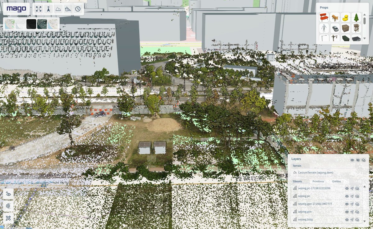
I'm very happy to share mago3DTiler workshop materials from the #FOSS4G Korea and FOSS4G-Asia. Download public datasets, convert them into OGC 3D Tiles and Quantized Mesh with mago3DTiler and mago3DTerrainer, and visualize them on the web using Cesium.js! https://t.co/CXn0nQLysv
OpenLayers v10.0.0 is out. Thanks to everyone who contributed. Breaking changes are few and minor, so everyone is encouraged to upgrade! https://t.co/K9xkS4KxDU
OpenLayers 9.2 is out! It's packed with fixes and features from 75 pull requests, including changes from 5 new contributors. Thanks to everyone who helped out. https://t.co/EQGj363qV7
I'll be showcasing "How to Build a Digital Twin Service in 10 Minutes with Open Source!" at the KSIS Spring Conference on May 16th. So, I tested DEM, buildings, realistic models, BIM, point clouds, and UGI, and it took only 9 minutes and 47 seconds! #DigitalTwin#mago3DTiler
Version 1.2 of iipsrv now released! Includes PNG and WebP output, TIFF image stack / OME-TIFF support, improved #IIIF support with full compliance for all Image API versions, HTJ2K support, improved Windows support, major performance improvements and more: https://t.co/CSUneBJUgR
Two releases on one day! A 7.5.2 patch release fixing an issue with vector hit detection, and the exciting version 8.0.0 with several API improvements and the new StadiaMaps source replacing Stamen. Thanks to everyone who contributed! https://t.co/d6Y6sXO1Ew
Happy 24th birthday to GDAL ! From the first commit on 1998-10-17 from a small rural town outside of Ottawa Canada, to almost every geospatial software installation on the planet (and satellites and other planets!) in 24 years. The ultimate example of sharing & community. #foss4g
We are just a little excited to bring you Mixed Format Labels coming in QGIS 3.28! You have @QGISCH to thank for funding our development of this fun feature! #gischat#QGIS#QGISAU Read more about it here https://t.co/WK7UmObyWg
Hot on the heels of 7.0, the OpenLayers 7.1 release is out. New tracing support while drawing 😍, more GeoTIFF features, improved story for users of the full build, and more. Thanks to all who contributed.
https://t.co/cvscgzGjii
More below 👇
Linux, Windows and Mac packages of point releases #QGIS 3.22.9 'Białowieża' (LTR) and 3.26.1 'Buenos Aires' ready on https://t.co/8GHALpmjLR. Make maps not war!
pgModeler received the first sponsorship! 🎉 It's satisfying to get this kind of recognition from the community. It really makes me happy and motivated on keep working on this project for years to come! You can join this special list too, don't miss it!
https://t.co/Qp38iu6yIa
We've released OpenSeadragon 3.1.0! It's mostly bug fixes, but it's also got some nice new features. Thank you, as always, to all of the contributors! https://t.co/EhGUVoNHbb
Great news! pgModeler 1.0.0-alpha1 is now fully ported to Qt 6, taking advantage of all toolkit's improvements including better support for hi-dpi screens. The video below gives you a hint on how is possible to tweak the entire UI to fit your needs!
https://t.co/tkGFNk3CGS
Linux, Windows and Mac packages of new point release #QGIS 3.22.5 'Białowieża' (LTR) and QGIS 3.24.1 'Tisler' ready on https://t.co/yGOw9OeDWA. Make maps not war!
The first release of GeoParquet is out! This is a new geospatial vector data (point, line, polygon) format that is built on Parquet, an awesome columnar-storage format. See https://t.co/e4Hd0A8qN9 for more information and join the growing community! (1/4)