Top Tweets for #Elevationdata

🎁Give yourself the gift of premium imagery from @vantortech, now available at SkyWatch-exclusive prices.
Limited-time offer ends Dec 31, 2025.
👉 https://t.co/ypd4ZL2Bpa
#satelliteimagery #satellitedata #basemaps #elevationdata #vantor


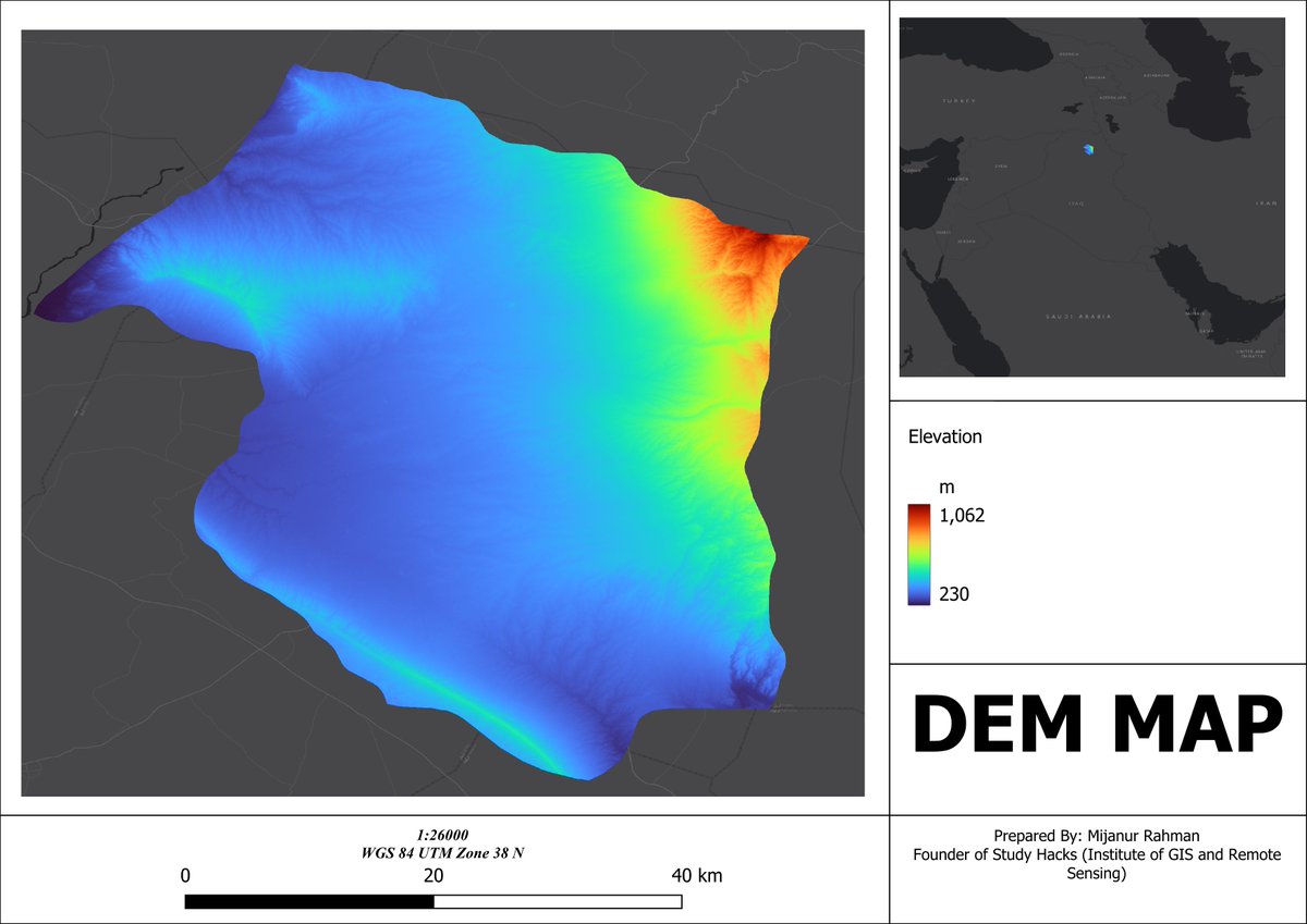
Quickly Download SRTM DEM Data for Any Study Area Using QGIS
Tutorial link: https://t.co/MmavOxFZdS
#SEO #QGIS #SRTM #DEM #RemoteSensing #GIS #Geospatial #Topography #ElevationData #Mapping #SpatialAnalysis #TerrainModeling #DigitalElevationModel #Geoinformatics

Join us at @AMEroundup Booth 1000 to explore how #SatelliteImagery and #ElevationData can support your #MineralExploration and #Mining goals and keep your projects moving forward. 🌍 🛰️


🌏 New ArcGIS Living Atlas updates (Oct 2023) include:
High-resolution elevation 🏔 data for France, Nebraska, Italy, and beyond, a new feet measurement 📏 raster function, and more.
🔗 See details: https://t.co/l5Q6RZD2yy
#GIS #ElevationData #geospatial

![USGS's tweet photo. [FAQ] Where can I get global elevation data? https://t.co/iZmE8EmZB2
#ElevationData🌎🗺️ https://t.co/u043FBbzUc](https://pbs.twimg.com/media/F7NAvTeXYAEzi8s.jpg)
![USGS's tweet photo. [FAQ] Where can I get global elevation data? https://t.co/iZmE8EmZB2
#ElevationData🌎🗺️ https://t.co/u043FBbzUc](https://pbs.twimg.com/media/F7NAvTWX0AABnVV.jpg)
![USGS's tweet photo. [FAQ] Where can I get global elevation data? https://t.co/iZmE8EmZB2
#ElevationData🌎🗺️ https://t.co/u043FBbzUc](https://pbs.twimg.com/media/F7NAvSaXwAAkB6n.jpg)

Sue Hoegberg describes how the 3D Nation #ElevationData program could generate $13.5 billion in benefits by helping federal agencies such as @NOAA and @USGS better prioritize and direct investment dollars to address user and community needs. Check it out: https://t.co/gfxxL6gIVf


Created this amazing relative elevation model (REM) of the Santee River as it branches off of Lake Marion. This was inspired by @geo_coe and created in @qgis using one-meter @usgs 3DEP digital elevation models. #qgis #gischat #cartography #elevationdata #southcarolina #3dep #dem


Thank you @NewOnGISCafe for the interview of Marie-Pierre Boutin, Sales & Marketing Director at @PlanetObserver_ on the latest release of PlanetSAT global imagery #basemap and PlanetDEM elevation dataset😀
Check it out here: https://t.co/tMerzxdv5S
#GISdata #elevationdata #GIS
Take a look at the huge difference between #PlanetDEM and AW3D30. Be aware of the limited quality of open-source DEMs.
PlanetObserver's goal is to make #ElevationDATA more reliable for your projects by correcting artefacts.
How many differences can you find?
#GIS #Geospatial
Completely realistic 3D data sets lead to a visually stunning solution for the end-user.
Check out how we were able to help @FlightPath3D and @MetraWeatherUK get an incredible UX!
https://t.co/EgoZ0xJc8l
#ElevationData #Geospatial #SatelliteImagery #Maps #MovingMaps

PlanetObserver is proud to announce its latest global elevation solution: #PlanetDEM. A medium-resolution Digital Surface Model adequate for both civil and military applications.
Find out more:
https://t.co/R2SOcNlI2u
#ElevationData #Geospatial #GIS #GISApplication #PlanetDEM

Check out our CEO discussing Intermap's next-generation 3D GEOINT solutions. @NewOnGISCafe #GEOINT #Mapping #GeospatialData #ElevationData
https://t.co/essV3gEBiH

Imagen construida a partir de datos LiDAR y GoogleMaps del Cerro del Chiqihuite.
#digital #software #tecnología #DEM #SpatialAnalyst #MDE #geodata #Elevationdata


We have big news to share! 🎉 We're excited to announce our newest program, #MetroHD city data, which delivers ultra-high-resolution 2D & #3D digital twins of global cities on demand. Learn more at https://t.co/ome47S9syE
#hxgncontent #aerialimagery #elevationdata @HxGNContent


The Elvis Elevation & Depth (https://t.co/56WJXN2CnK) has changed recently.
We have released a new front end interface based on feedback in our last survey which includes a number of improvements
•New Search which includes an address search
•New Tools
#FSDF #ElevationData


This article outlines the common sources of elevation data, including space-based radar, and helps to categorize the data quality and accuracy.
#GIS #ElevationData #Mapping #Data #Geospatial #3D #Lidar https://t.co/wykDLYy0Jv

Did you know you can easily view and download our published #elevationdata at https://t.co/0z4p5vFhBt?
The recently published data for Haines is shown below.

New release! RDF 2021-2, Lidar-derived elevation models for Homer, Alaska https://t.co/mGrMLu5mtN
#elevationdata #lidar
Last Seen Hashtags on Sotwe
Trends for you
Most Popular Users

Elon Musk 
@elonmusk
240.3M followers

Barack Obama
@barackobama
119.3M followers

Donald J. Trump
@realdonaldtrump
111.6M followers

Cristiano Ronaldo
@cristiano
109.7M followers

Narendra Modi
@narendramodi
106.9M followers

Rihanna
@rihanna
97.4M followers

NASA
@nasa
92.1M followers

Justin Bieber
@justinbieber
90.7M followers

KATY PERRY
@katyperry
87.2M followers

Taylor Swift
@taylorswift13
81M followers

Lady Gaga
@ladygaga
72.6M followers

Kim Kardashian
@kimkardashian
69.6M followers

Virat Kohli
@imvkohli
69.2M followers

YouTube
@youtube
68.6M followers

Bill Gates
@billgates
63.6M followers

The Ellen Show
@theellenshow
62.5M followers

CNN
@cnn
61.9M followers

Neymar Jr
@neymarjr
61.8M followers

X
@x
60.9M followers

Selena Gomez
@selenagomez
60.3M followers