

Top Tweets for #FOCUSNOW

DWM ENSO WATCH UPDATE DATED 6TH SEPTEMBER, 2026 | 6:30 AM IST
#BIGBREAKING #FOCUSNOW
#Topic: ECMWF Nino 3.4 plume points to a November peak near +4.0 °C.
==> The latest ECMWF Nino 3.4 plume has been released. It shows the current El Nino peaking around +4.0 °C above the 1991–2020 average in November.
==> For comparison, the recent El Nino record monthly peak was about +2.8 °C in November 2015. If this trajectory holds, 2026 would rewrite the instrumental record.
==> Ocean and atmosphere remain coupled as trade winds continues to stay weak, SOI stays strongly negative, and convection is shifted east of normal. Kelvin wave heat is still feeding the surface.
==> Earth is already reflecting El Nino’s split personality. The Atlantic is having a historically quiet season no hurricanes so far, only a few short-lived tropical storms.
==> On the other side, the Pacific is hosting record breaking triplet cyclones, with a higher than normal typhoon/hurricane count so far this year. Lowell, Karina, Bavi and Sinlaku are the best example of that contrast.
==> Southwest monsoon over India has been affected. Rainfall activity has stayed disturbed through the last few months under sinking air and weak monsoon organisation.
==> Super El Niño rule remains the same: today’s heat in the Pacific is tomorrow’s drought, flood and cyclone contrast on land.
Stay locked with @Deltarains for real time ENSO, monsoon and cyclone monitoring.
Thanks & Regards
R. Hemachander, Msc (Climate change)., M.E (Environmental Engineering).
Climate Activist | Independent Weather Blogger
Email: [email protected]
#Disclaimer: This update represents my personal analysis and interpretation.
#ElNino #SuperElNino #ENSO #Nino34 #ECMWF #AtlanticHurricane #PacificTyphoon #SouthwestMonsoon #ClimateUpdate #DeltaRains


#BIGBREAKING #FOCUSNOW
DWM SUPER ELNINO MONITORING UPDATE DATED 5TH AUGUST, 2026 6:30 PM IST
“Super El Nino Impacts: Today in the Ocean, Tomorrow on our Land”
#Topic: Nino 3.4 region of the Pacific Ocean now more than 2.0°C above average Super El Niño has emerged!
==> Non-stop westerly wind bursts, combined with the effects of three major super typhoons (#Sinlaku, #Bavi, and #Dolphin) prior to August and the influence of a Kelvin wave, have driven sea-surface temperatures in the Nino 3.4 region more than 2.0°C above the long-term average.
==> The emergence of Super El Nino conditions by late July and early August is unprecedented. For comparison:
1. Early Aug of 2015: +1.12°C
2. Early Aug of 1997: +1.61°C
3. Early Aug of 1982: +1.20°C
==> The 2026 event is clearly distinct from previous Super El Nino years and is currently on a trajectory toward record intensity. Standing wave conditions and intense westerly wind bursts are expected to sustain intense super typhoon activity over the next three months. As a result, the Super El Nino is likely to reach its peak only in November.
==> Conditions remain favorable for Nino 3.4 anomalies to exceed +3.0°C by late October to early November. This event has the potential to become the strongest Super El Nino on record, with anomalies possibly approaching +3.5°C by November.
==> We have to note peak typhoon season of Pacific Ocean is August to October. So, hyper active pacific typhoons expected in next few months which will fuel the historical Super El Nino.
==> Simultaneously, the Southern Oscillation Index (SOI) has remained around –29 for several weeks, indicating that the El Nimo is now coupling with the atmosphere.
==> In response to , the Indian Ocean and Atlantic Ocean basins are expected to begin reacting. Development of a positive Indian Ocean Dipole (IOD) and a negative Pacific Decadal Oscillation (PDO) appears increasingly likely in the coming weeks.
Please remain connected with @deltarains on X for real-time updates as conditions evolve.
Thank you.
R. Hemachander, https://t.co/jAwt1q9Cyd., M.E.
Climate Activist | Independent Weather Blogger
[email protected]
*Disclaimer: This update reflects my personal analysis and interpretation.*

#BIGBREAKING #FOCUSNOW
#Topic: ECMWF latest forecast strengthening the El Nino projection further.
Strong Signal: Nearly all ensemble members forecast a powerful El Nino, with Nino 3.4 anomalies exceeding +3.0°C; several scenarios reach +4.0°C by late 2026.
Historic Potential: Could become the strongest El Nino in the modern record, surpassing 1997/98 and 2015/16 events. In all the way it can also beat 1876 strongest El-Nino event.
Current Status: Rapid warming and high subsurface heat already observed in the equatorial Pacific, ocean-atmosphere coupling strengthening.
Official Consensus: 80–98% probability of El Nino through winter 2026–27; 1-in-3 chance of a “very strong” event (NOAA/IRI)
Key Impacts:
1. Record breaking global surface temperatures in 2027.
2. Extreme weather: flooding in the Americas; drought & wildfires in Southeast Asia, Australia, southern Africa.
3. Major agricultural stress and monsoon disruptions.
4. Accelerated ocean warming and marine heatwaves.
5. Record breaking heat waves, heat stress across the world.
World may not ready to see this historical event..it's time for speed up the preparations & precautions.
#elnino #superelnino #ECMWF #heatwaves #drought #floods #climateemergency


Your future is watching what you do today. 👀💫
Make it proud.
#FutureGoals #FocusNow #DailyGrind #SelfGrowth #StayMotivated
#BIGBREAKING #FOCUSNOW
==> The Northeast Monsoon (NEM 2025) has now ceased over Southeast Peninsular India as of today, January 19, 2026.
==> Since 2020, the persistent La Niña background has led to consistently extended monsoon activity, bringing excess winter rainfall during January and February in many years.
==> This pattern has continued into 2026 as well, with notable late-season spells impacting the region right up to mid-January before the final withdrawal.
THANKYOU NEM2025

#BIGBREAKING #FOCUSNOW
As we expected earlier, IMD has pushed the Landfall location to North Srilanka from South Srilanka coasts.

DWM DEEP DEPRESSION UPDATE - 6| DATED 08.01.2026| 11:00 AM
#Topic: Will IMD change the landfall location?
==> The depression over central parts of South Bay of Bengal has intensified into a Deep depression and persists over Southwest Bay of Bengal and neighborhood.
==> It likely to move west direction during next 24 hrs and then take sharp west-northwest direction towards North Srilanka and adjoining Delta coasts during subsequent 48 hrs.
==> Under the influence of land interaction deep depression likely to weaken into a depression around 10th Jan morning hours.
==> However, expecting IMD to make major changes in the track of the system. Likely to push the system more North-Northwest direction towards North Srilanka and adjoining Palk strait area.
==> North coastal TamilNadu especially #Cuddalore, #Mayiladuthurai, #Nagapattinam, #Thiruvarur, #Thanjavur, #Karaikal, #Pudhucherry, #Villupuram farmers should be high alert on Jan 10th & 11th, 2026.
Stay tuned & connected with @deltarains on X for timely updates as the system evolves! 🌧️
Thanks & Regards
Hemachander R
Independent weather blogger
Email: [email protected]
Disclaimer: This is purely my personal view and interpretation. Please do not bring other views from official agency or other private weather bloggers here. Understand that this is my own perspective, and I am ready to explain any queries regarding my post, not those of others.
#Deltarains #Chennairains #Deepdepression #Januaryrains
#Harvestheavyrains

#BIGBRRAKING #FOCUSNOW
NAGAPATINNAM DT KODIYAKARAI TOP'S THE TABLE WITH 250MM EXTREMELY HEAVY RAINFALL
DWM "DITWAH" CYCLONE UPDATE -8| DATED -29.11.2025| TIME : 8:30 AM
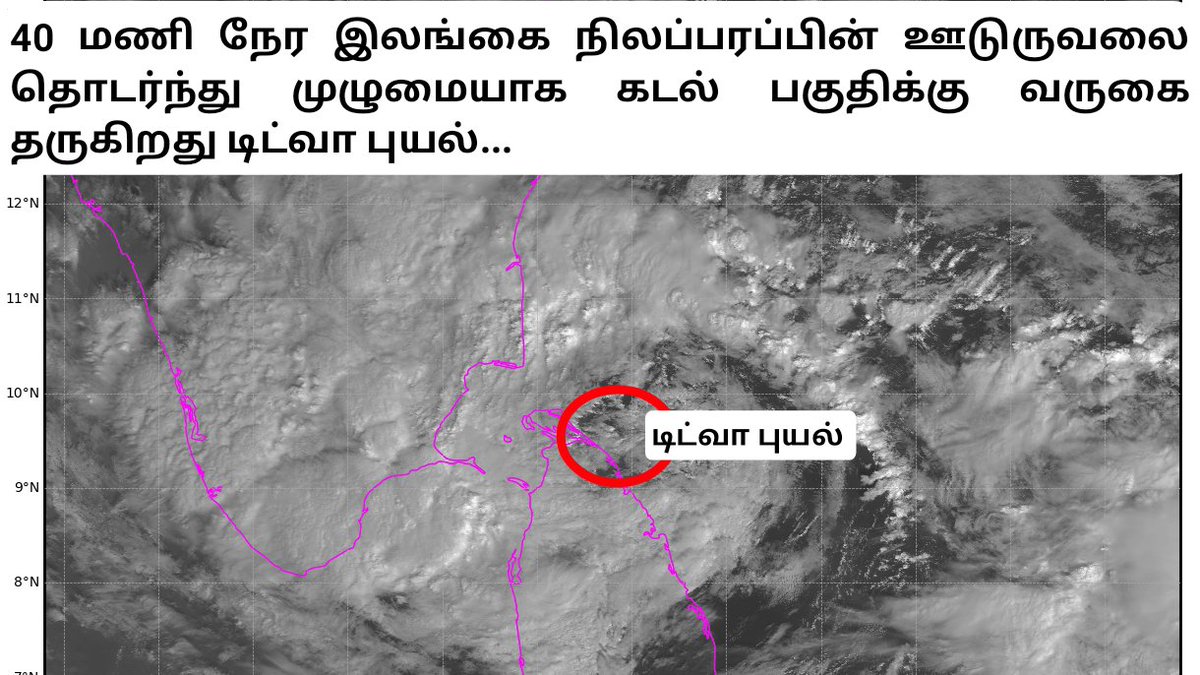
#Topic: AFTER 40 HRS OF LAND INTERACTION, DITWAH MAKING GRAND ENTRY TO DELTA COASTS.
==> Nearly 40 hrs of srilanka land interaction, cyclone #Ditwah has entering delta coasts in very next hour. As of 8:30 AM today (29 November 2025), the Cyclone Ditwa is located approximately 170 km south-southeast of Nagapattinam and 180 km from Karaikal.
==> Extremely heavy rains recorded at Nagapatinam dt, Kodiyakarai tops with 250mm Vedaranyam 185mm, Velankkani 133mm, Thirupoondi 123mm, Nagapattinam 116mm. Nagapattinam dt averagely recorded 140mm.
==> The cyclone is continuing to move in a northerly direction and is expected to regain it's strength further as it approaches the Delta coast in the next few hours. The western quadrant of the cyclone is likely to begin affecting land areas in the Delta region during later par of today.
==> Heavy rain has now started in #Nagapattinam, #Tiruvarur, #Thanjavur, and #Mayiladuthurai #Cuddalore #Karaikal and #Pudhucherry districts, and it will gradually increase in intensity over the coming hours.
==> As the cyclone makes land interaction on the western quadrant of the Delta today (29 November) during the daytime, extremely heavy rainfall is expected across the region. People in the Cauvery Delta are requested to remain extremely cautious for the next 24 hours.
==> After impacting the Cauvery basin, the cyclone is expected to track its northward movement from this evening or night onwards.
==> Rain will begin in Chennai and other North coastal districts in the coming hours, and widespread heavy to very heavy rainfall, with extremely heavy falls at times, is likely from tonight (29.11.2025) until the morning of 1 December 2025.
==> Heavy rains likely to continue over South & interior Tamilnadu as well. Dts like #Pudhukottai, #Ramanathapuram, #Thoothukudi, #Theni, #Tenkasi, #Kanyakumari also will get heavy rains today. Most of the interiors also have good rain chances.
#ImportantNote: People in the Cauvery Delta districts are strongly advised not to leave their homes today.
Stay tuned for further live updates on Cyclone Ditwah.
Stay tuned & connected with @deltarains on X for timely updates as the system evolves! 🌧️
Thanks & Regards
Hemachander R
Independent weather blogger
Email: [email protected]
Disclaimer: This is purely my personal view and interpretation. Please do not bring other views from official agency or other private weather bloggers here. Understand that this is my own perspective, and I am ready to explain any queries regarding my post, not those of others.
#Cycloneditwah #chennairains #Deltarains
#BIGBREAKING #FOCUSNOW
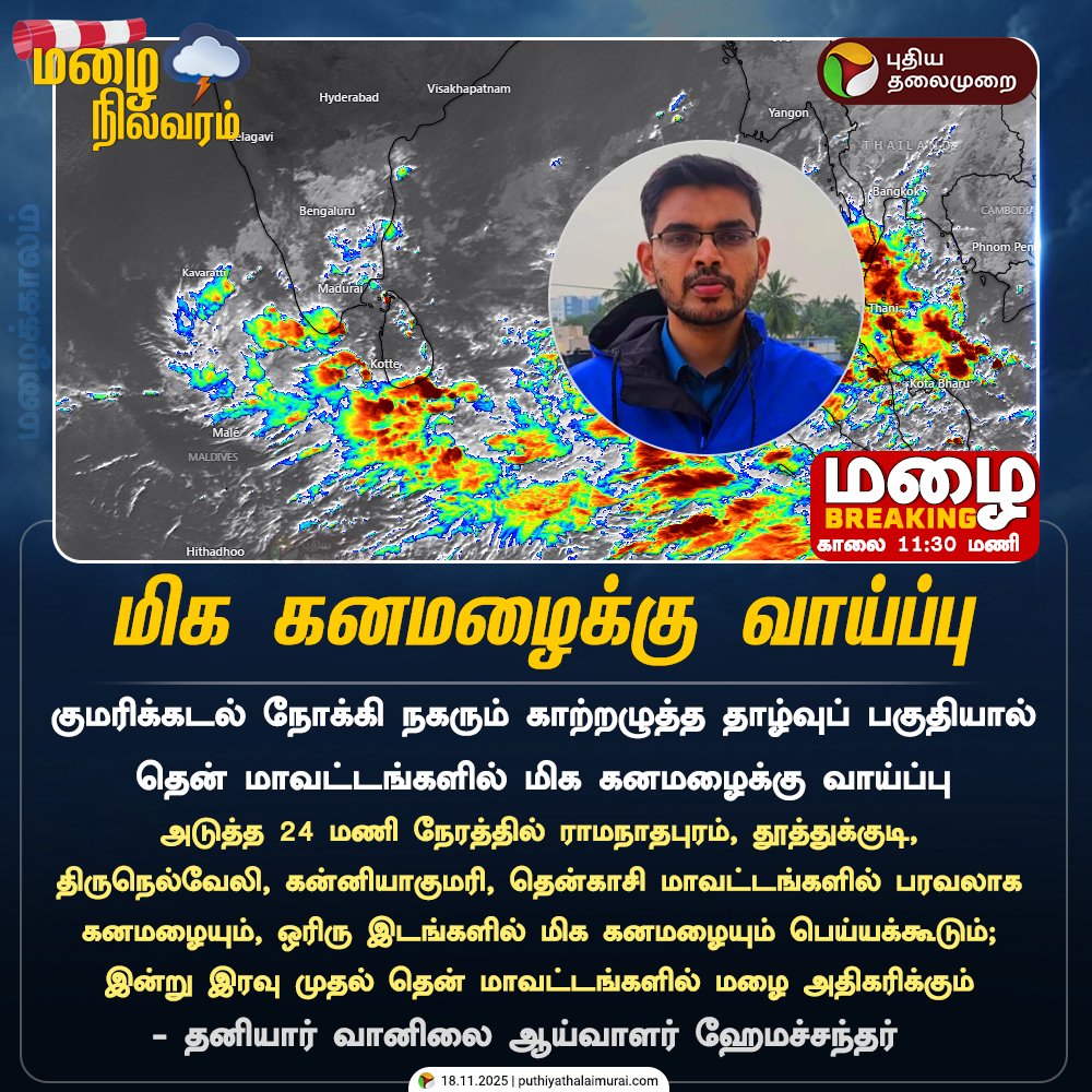
திருநெல்வேலி மாவட்டத்தில் அதிகனமழை பதிவு, பம்பா செல்லும் ஐயப்பன் பக்தர்களுக்கு முக்கிய அறிவிப்பு!
==> இன்று (20.11.2025) காலை 8:30 மணி நிலவரப்படி தென் மாவட்டங்களில் பரவலாக கொட்டி தீர்த்த கனமழை
==> திருநெல்வேலி மாவட்டத்தின் பள்ளதாக்கு பகுதிகளான #ஊத்து 23 செ.மீ, #நாலுமுக்கு 21 செ.மீ அளவிற்கு அதித கனமழை பதிவு, #கக்காச்சி 19 செ.மீ, #மாஞ்சோலை 18 செ.மீ அளவிலும் மழை பதிவு*
==> தென்காசி மாவட்டம் #ஆயக்குடியில் 14 செ.மீ, #தென்காசியில் 13 செ.மீ, #செங்கோட்டையில் 10 செ.மீ அளவிலும் மழை பதிவு.
==> தூத்துக்குடி மாவட்டம் #காயல்பட்டினம் 10 செ.மீ, #சாத்தான்குளம் -9.4 செ.மீ, #திருச்செந்தூரில் - 8 செ.மீ அளவிற்கு மழை பதிவு.
நேற்றைய பதிவில் குறிப்பிட்டிருந்தது போல குற்றாலத்தில் வெள்ளப்பெருக்கு ஏற்பட்டுள்ளது.
பம்பா செல்லும் ஐயப்பன் பக்தர்கள் மேற்குதொடர்ச்சி மலை பகுதிகளில், நீர்வீழ்ச்சிகளில் குளிப்பதை அடுத்த இரண்டு நாட்களுக்கு தவிர்க்கவும்.
என்றும் இயற்கையுடன்
டெல்டாவெதர்மேன் ஹேமச்சந்தர்
DWM NOWCAST WEATHER UPDATE FOR 3RD ROUND OF RAINS| UPDATE-10 | 18.11.2025| 12:30 PM
#Topic: South TamilNadu likely to see widespread Heavy to Very rainfall today!
==> As the low pressure system moves into the Comorin Sea area, interior and southern Tamil Nadu will start receiving rainfall from this evening/night onwards.
==> Valley regions such as #Kakkachi, #Oothu, and #Nalumukku may witness intense rainfall activity. Being closed valley locations, significant impacts like flooding are less likely.
==> Overall, southern Tamil Nadu will become active with widespread rain from today.
==> #Cuttralam, #Thirparrapu falls likely to see increase in water flow and possible flooding during next two days.
==> Other parts of Tamil Nadu, including coastal and delta regions, can expect on and off rainfall activity in the coming hours/days. South Tamil Nadu wakes up to the rainy season! 🌧️
#Disclosure: This is not an extreme or alarming event. It’s simply the Northeast Monsoon waking up, bringing active conditions with widespread moderate to heavy rains across coastal Tamil Nadu, exactly what the season needs.
Stay tuned & connected with @deltarains on X for timely updates as the system evolves! 🌧️
Thanks & Regards
Hemachander R
Independent weather blogger
Email: [email protected]
Disclaimer: This is purely my personal view and interpretation. Please do not bring other views from official agency or other private weather bloggers here. Understand that this is my own perspective, and I am ready to explain any queries regarding my post, not those of others.
#BIGBREAKING! #FOCUSNOW!
#Topic: Rainfall numbers of South TamilNadu.
Thirunelveli western ghats (Valley region) has recorded extreme heavy rains on 19.11.2025 8:30 am ending.
#Thirunelveli toppers:
Oothu - 23 cm,
Nalumukku - 21 cm,
Kakkachi - 19 cm,
Manjolai - 18 cm,
#Tenkasi toppers
Ayikudi - 14 cm,
Tenkasi - 13 cm,
Shencottai - 10 cm,
#Thuthukudi toppers
Kayalpattinam - 10 cm
Sathankulam - 9 cm,
Thiruchendur - 8 cm
#BIGBREAKING #FOCUSNOW
DWM SPECIAL UPDATE DATED 10TH NOV, 2025
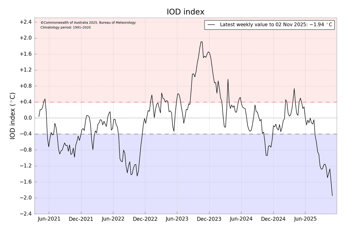
#Topic: Negative IOD peak has begin to break down.
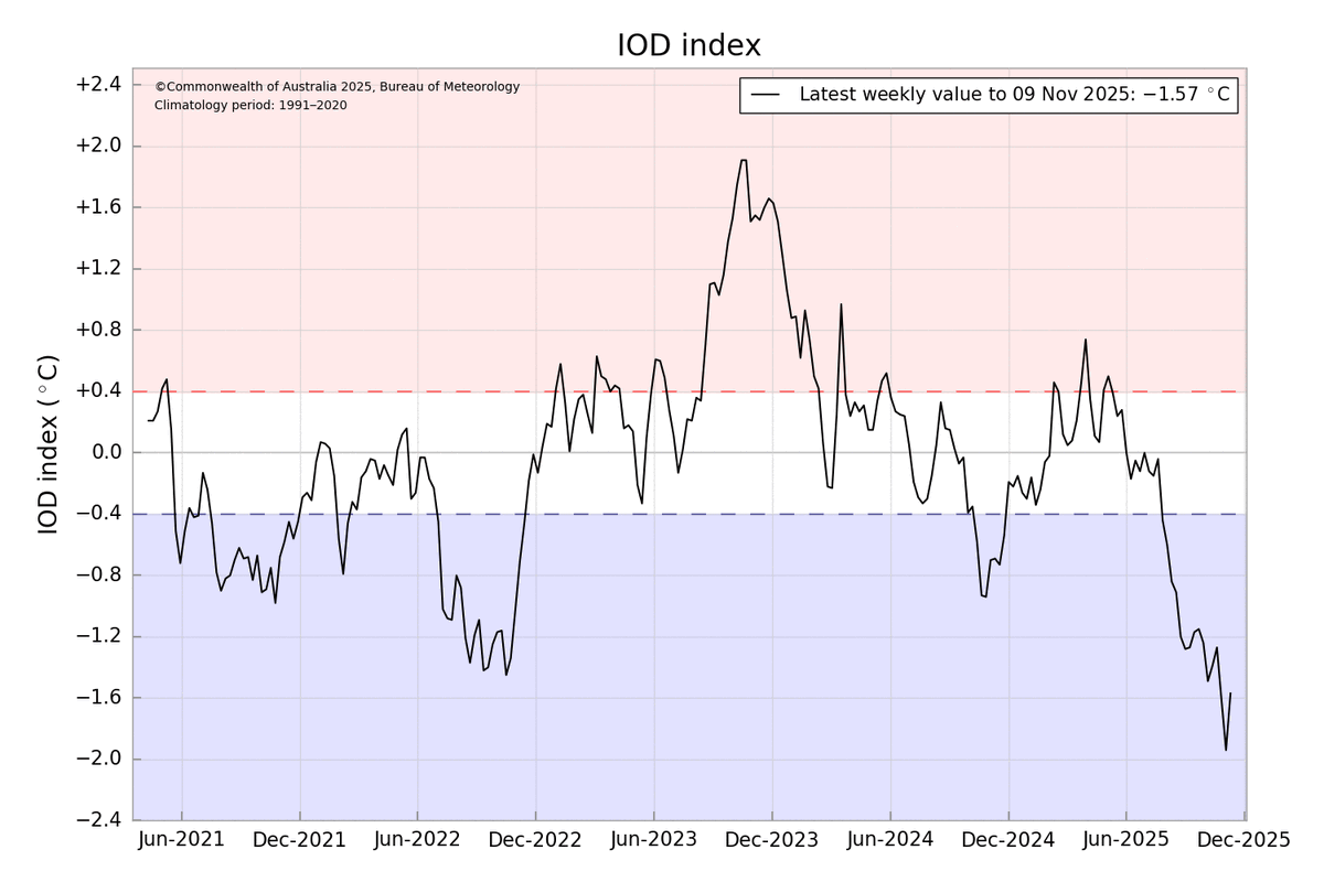
==> As hinted few days back, the latest IOD index has surged to -1.57°C. The peak negative Indian Ocean Dipole phase is now beginning to break down. Exciting days ahead!
==> The stage is perfectly set for a strong negative IOD base state coupled with a classic standing planetary wave pattern.
==> Get ready Kelvin waves, Rossby waves, and the MJO are lining up to take turns. The real monsoon engine is about to kick into high gear! 🌧️🚀
Thanks & Regards
Hemachander R
Independent weather blogger
Gmail: [email protected]
#Climatechange #Bayofbengal #Arabiansea #cyclones
DWM NIOD SPECIAL UPDATE DATED 6TH NOV, 2025
#Topic: Collapse of Strong Negative IOD & SST warming off TamilNadu coasts.
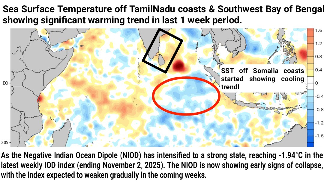
==> The strong Negative Indian Ocean Dipole (NIOD) has begun to decline. The latest weekly IOD (Nov 2, 2025) index reached -1.94°C, marking a peak intensity over the past few days.
==> Recent data now reveals a gradual cooling trend in sea surface temperatures off the Sumatra coast, confirming that the NIOD has crossed its maximum strength and is slowly weakening.
==> This collapse is expected to keep activate cross-equatorial westerlies at East Indian Ocean over the coming weeks.
==> Arrival of full-fledged easterlies from the South China Sea & presence of cross equatorial westerlies, creates a highly favourable environment for the formation of a significant weather system during second half of November.
==> Meanwhile, sea surface temperatures along the Tamil Nadu coast and in the southwest Bay of Bengal are showing a clear warming trend, a classic precursor to an active Northeast Monsoon phase.
==> As the pattern evolves, a mid-November easterly wave will be worth monitoring closely, likely heralding the first widespread rainfall spell over Tamil Nadu.
==> Full-fledged easterlies are anticipated to arrive around 12th November, followed by a trough or weak low associated with the easterly wave. This setup should trigger widespread rainfall across most parts of Tamil Nadu during 15–20 November 2025.
==> Until then, isolated thunderstorms will continue, keeping the atmosphere primed while both oceanic and atmospheric parameters align for the upcoming vigorous monsoon phase.
Thanks & Regards
Hemachander R
Independent weather blogger
Email: [email protected]
Disclaimer: This is purely my personal view and interpretation. Please do not bring other views from official agency or other private weather bloggers here. Understand that this is my own perspective, and I am ready to explain any queries regarding my post, not those of others.
#ChennaiRains #Deltarains #NEM2025 #Thunderstorms #lightning #heavyrains
#BIGBREAKING! #FOCUSNOW!
DWM SPECIAL UPDATE ABOUT PEAK NEGATIVE IOD CONDITIONS DATED: 3RD NOV 2025
#Topic: Negative IOD Reaches Record-Breaking Peak!
==> The latest weekly IOD value (ending 2nd November) has reached -1.94°C, marking a record-breaking peak. Sumatra coasts continue to warm, indicating that NIOD may reach -2.0°C within the next week.
==> The sustained peak trend of Negative IOD is expected to gradually weaken after 10th November.
==> This record-breaking Negative IOD is a key factor behind the abnormally hot conditions observed in early November.
==> An upcoming pulse of planetary waves is likely to get trapped over the East Indian Ocean and Maritime Continent due to NIOD forcing. This could lead to prolonged monsoon activity during the second half of the season.
==> Interesting days ahead! #NEM2025 going to do more wonders!
Stay tuned & connected with @Deltarains on X for timely weather updates.
Thanks & Regards
Hemachander R
Independent weather blogger
Email: [email protected]
#NegativeIOD #Indianoscillationdipole #Bayofbengal #ClimateCrisis
#FOCUSNOW #BIGBREAKING
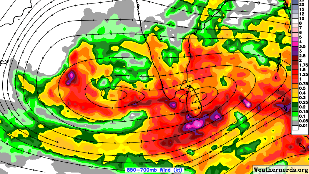
#CYCLONEMONTHA
IMD also has confirmed that cyclone likely to cross between Machilipattinam and Kalingapattinam near #Kakinada.
Keep fingers crossed! Landfall place has locked!
Will Chennai lock the rains? Stay connected..
புயல் உங்களுக்கு, மழை எங்களுக்கு (#சென்னை)


#FOCUSNOW, #BIGBREAKING!
As we discussed yesterday, Southwest Bay of Bengal vortex won the battle!
A fresh low pressure area has formed over Southwest Bay of Bengal!
IMD has declared official announcement.

DWM Special Update about developing low dated 20th Oct, 2025
#Topic : Southwest Bay Vortex vs. Southeast Bay Vortex – Who Will Prevail?
==> An elongated trough of low extends from east of Sri Lanka to the Andaman Sea.
==> The vortex near Sri Lanka is expected to strengthen into a low-pressure area over the Southwest Bay of Bengal by tomorrow. However, the India Meteorological Department (IMD) anticipates a low-pressure area forming in the Southeast Bay of Bengal.
==> It remains to be seen whether the IMD will shift its forecast to align with the Southwest Bay of Bengal low-pressure formation off Sri Lanka.
==> Convection is intensifying along the Tamil Nadu coast and the Southwest Bay of Bengal. Favorable conditions, including phase 3 MJO presence, strong convergence, divergence, and low wind shear, are likely to support the formation of a low-pressure area off the Sri Lanka coast in the Southwest Bay of Bengal by tomorrow. There is a high probability that this system could further intensify into a depression.
==> Rainfall activity is expected to increase gradually from late tonight. Widespread heavy rainfall is anticipated over coastal Tamil Nadu starting late tonight and continuing into early tomorrow morning.
==> The second round of the Northeast Monsoon (NEM) is likely to bring a more dynamic phase between October 21 and 24, 2025. Stay tuned for further updates.
Interesting days ahead!
Thanks & Regards
Hemachander R


#BIGBREAKING #FOCUSNOW
Delta Weatherman Hemachander's Important Announcement Date: 20.10.2025, 11:30 AM
Headline: Second Phase of Northeast Monsoon Intensifies Tonight!
==> A trough of low has formed over the southwest Bay of Bengal near Sri Lanka. This will likely develop into a low pressure area by tomorrow (21.10.2025).
==> Starting tonight (20.10.2025), the second phase of the northeast monsoon will intensify.
Weather Forecast (From Evening/Night of 20.10.2025 to Morning of 21.10.2025):
Widespread Heavy Rainfall expected in districts including #Thoothukudi, #Ramanathapuram, #Thiruvarur, #Nagapattinam, #Karaikal, #Mayiladuthurai, #Cuddalore, #Villupuram, #Chengalpet, #Chennai, #Thiruvallur and #Kanchipuram dts. Isolated coastal areas might see very heavy rainfall activity.
==> Heavy rainfall likely in districts such as #Kanyakumari, #Tirunelveli, #Nilgiris, #Coimbatore, #Pudukkottai, #Thanjavur dts.
Interior Districts: Scattered moderate to slightly heavy rainfall expected.
Special Note: Coastal areas of Ramanathapuram, particularly #Rameswaram, #Pamban, #Thangachimadam, are likely to experience intense rainfall tonight.
Thanks & Regards
Hemachander R
#ChennaiRains #deltarains
#BIGBREAKING #FOCUSNOW
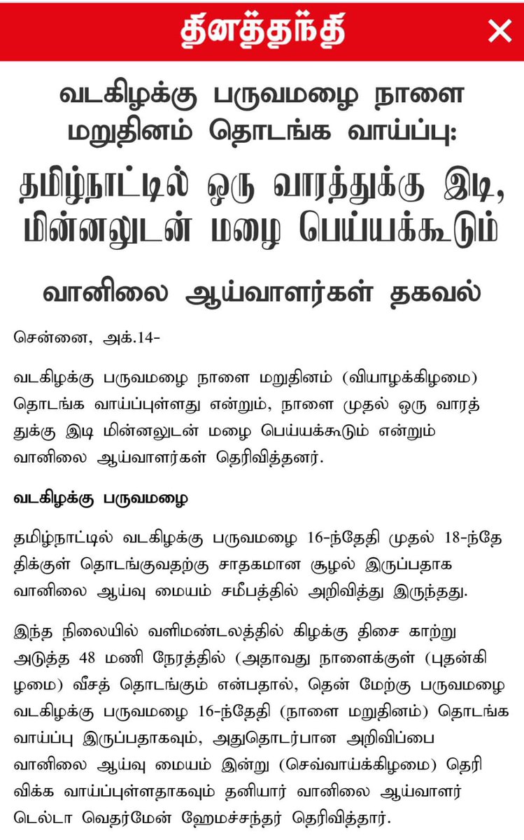
IMD is officially expecting the Northeast monsoon onset on October 16th, 2025

#FOCUSNOW #BIGBREAKING
NEM ARRIVING IN NEXT 48 HRS
The Northeast Monsoon is expected to commence in Tamil Nadu on October 16, 2025. A detailed article on the onset spell and the first round of rainfall (15-21st Oct) was published in today's Daily Thanthi newspaper across all Tamil Nadu editions.
#Focusnow #Bigbreaking
DWM SPECIAL UPDATE
==> On September 1st, we released our detailed long-range forecast for the 2025 Northeast Monsoon. Now, we’re excited to launch a series of posts to dive deep into the science behind our prediction.
#Topic of the series: Why 2025’s Northeast Monsoon Will Shine? Decoding the Outlook.
==> In this series, we’ll break down the key atmospheric and oceanic parameters that support our outlook for an impactful monsoon season.
==> We’ve already explored our first topic two days back. Why November 2025 Weather Systems Will Impact North Tamil Nadu?
==> This evening, get ready for another fascinating parameter that shapes our forecast!
Stay tuned for more insights, and let’s crack the code together.
Thanks & Regards
Hemachander R
#NEM2025 #Monsoon2025 #Chennairains #Deltarains
DWM Special Update, Dated: Oct 6, 2025
Topic: Why November 2025 Weather Systems Impact North Tamil Nadu?
==> In our detailed Northeast Monsoon outlook, we anticipated that back to back Depression/Cyclone is likely to affect North Coastal Tamil Nadu.
This article explores one of the key reasons supporting this forecast.
Historical Context (2020–2024):
==> The years 2020, 2021, 2022, and 2024 were characterized by La Niña conditions, while 2023 was an El Niño year. 2025 is expected to be the fifth consecutive La Niña-influenced year.
==> Pretty same kind of pattern also prevailed during 1970-1975, 5 years was a La-Nina and 1 El-Nino year by that period as well.
#KeyObservations:
Picture 1: Weather System Tracks (2020–2024):
==> Systems originating in the Southwest, Southeast, and Southern Bay of Bengal during NEM period have consistently moved toward North Tamil Nadu coasts, resulting in significant rainfall.
Systems forming in the West Central Bay of Bengal typically moved northward, particularly in October, which is typical during end of Southwest monsoon period.
Picture 2: November-Specific Trends:
==> All weather systems formed in the Bay of Bengal during November (2020–2024) have crossed North Tamil Nadu coasts, except in 2023, the El Niño year.
Analysis:
==> This historical pattern suggests that North Tamil Nadu and the Delta region are likely to experience weather systems in November 2025, given the La Niña background.
==> While this analog is not the sole basis for our forecast, it also a significant important factor behind our long range forecast.
==> In the coming days, we will share further insights into the fundamental background reasons behind our long-range outlook for the Northeast Monsoon.
#NEM2025 #Chennairains #Deltarains #Thunderstorms #Monsoon2025


#BigBreaking #Focusnow
#Shakthicyclone, the first named cyclone of this year (2025), is cooking at Arabian Sea . Conditions are becoming favourable for the system to intensify further into severe cyclonic storm during next 24 hrs. Very recent intensity shows 35 knots and has a pressure drop of 996 mb probably it's attained cyclone strength. Official announcement will come today evening. It unlikely to make any land impact, expected to weaken in open sea water due to dry air incursion.
Srilanka has given the name #Shakthi


Your phone’s eating your time, and you’re letting it.
Feel the burn?
Our eBook detoxes your brain.
Free today, act now!
Change your perspective forever.
#DigitalFreedom #FocusNow
https://t.co/zWbl6pgNVs
Last Seen Hashtags on Sotwe
anxiouspanda(***************************()******)filter:videos
Seen from Belgium
helevier
Seen from Italy
春日部エバーチャイルド
Seen from United States
achillelauro
Seen from Italy
momsonn()(*)(*)(*) filter:videos
Seen from Brazil
cuckson #gangbang
Seen from Italy
FarmExperience
Seen from United States
مبادل_الحفر
Seen from Saudi Arabia
momsonbedroom
Seen from Netherlands
bbw #onlyfans
Seen from United States
Trends for you
Most Popular Users

Elon Musk 
@elonmusk
241.5M followers

Barack Obama
@barackobama
118.8M followers

Cristiano Ronaldo
@cristiano
114.6M followers

Donald J. Trump
@realdonaldtrump
111.8M followers

Narendra Modi
@narendramodi
107.1M followers

Rihanna
@rihanna
98.7M followers

NASA
@nasa
92.3M followers

Justin Bieber
@justinbieber
91.8M followers

KATY PERRY
@katyperry
90.1M followers

Taylor Swift
@taylorswift13
84M followers

Lady Gaga
@ladygaga
75.5M followers

Virat Kohli
@imvkohli
73.5M followers

Kim Kardashian
@kimkardashian
70.9M followers

YouTube
@youtube
68.8M followers

Neymar Jr
@neymarjr
66.5M followers

Bill Gates
@billgates
65.3M followers

Selena Gomez
@selenagomez
63.1M followers

The Ellen Show
@theellenshow
62.2M followers

CNN
@cnn
61.7M followers

X
@x
60.7M followers