Top Tweets for #GIStools

nice! 🤩 #GISTools


Where is the visualisation showing the predicted timing and extent of flood impacts based on the hydrological models. And where is the discussion around uncertainty in the forecast so we can have full information for decision making
#probabilisticforecasts

Training on Wetland Vulnerability Analysis using #GIStools and #EarthObservationdata is ongoing.
Great appreciation to @esipps , @_AfricanUnion, @RCMRD_ for the support.

Het einde van #datadinsdag. Binnenkort tijd voor iets nieuws? En wat dan? Wat zouden jullie graag periodiek terug willen zien in onze tijdlijn?
Wij gaan er even over nadenken, tips zijn zeker welkom! #data #geo #maps #gistools #georesearch #researchIT
Vandaag was de laatste #datadinsdag.
Teruglezen van het hele alfabet kan via https://t.co/xA9R4RsRam
Als student of medewerker op zoek naar een (geo)dataset voor onderzoek of onderwijs @univgroningen? Wij staan klaar om te helpen! 💪
https://t.co/17eEQGmdVt


Distance measurement tool lets fire dispatchers measure the distance from the road where the fire truck is going to park to the building on fire.
Try it at https://t.co/KdGZkcAzPh and DM us for more info about Kontur Platform solutions.
#dispatcher #firefighter #gistools

Area measurement tool lets fire dispatchers quickly estimate the scale of the reported fire.
Try it at https://t.co/KdGZkcAzPh and DM us for more info about Kontur Platform solutions.
#dispatcher #firefighter #gistools


17 reasons to map like a Pro using ArcGIS Pro! Seriously, if you haven't migrated yet you're missing out.
Article by @GisGeography
#ArcGISPro #Esri #GISTools
https://t.co/amzxkA6zug


#GISandPRACTICE #Nov19 on #PresovSelfgoverningRegion and #PresovUniversity. Data sprints & meetings to create some tourist's products with #georchestra an other #gistools. Thanks to #PSK #UNIPO #WB #KGAG & #QGIS


You coulnd’t make it to our webinar? No worries, you can watch the recording!
https://t.co/DVxjpblFYv
--
#webinar #dronebusiness #UAVmapping #UASmapping #objectDetection #MachineLearning #AI #SmartGIS #GIStools #AImapping
What size of object you are looking for? Size filter reduces noise, create targeted subsets of detection results
Try now on https://t.co/jpDyYZxAET!
#AI #MachineLearning #dronemapping #GIStools #DroneBusiness #ObjectDetection #RemoteSensing #GIS #SmartGIS
It’s official, we are launching paid plans. The Pro & Premium plans have all you need to take your object detection workflow to the next level. Learn more https://t.co/cwhPIWK66u
…
#artificialintelligence #dronemapping #objectDetection #GeospatialAnalytics #GISTools #SmartGIS
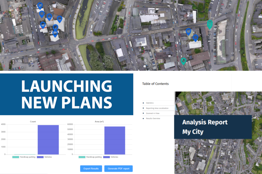
NEW! Customize your stats, export results and generate PDF reports. The Stats & Report panel is available in Pro and Premium plans. Upgrade your account https://t.co/ETHjHZkgG8
...
#artificialintelligence #dronemapping #objectDetection #GeospatialAnalytics #GISTools #SmartGIS
See your detection results as markers or as polygons.
Go to https://t.co/ny7ln2YLjX and try it now!
#artificialintelligence #MachineLearning #dronemapping #GIStools #DroneBusiness #objectDetection #GeospatialAnalytics #remoteSensing #GIS #SmartGIS #MapMakers
New! Choose how you want to see your detection results
Go to https://t.co/ny7ln2YLjX and try it
#artificialintelligence #MachineLearning #dronemapping #GIStools #DroneBusiness #objectDetection #GeospatialAnalytics #remoteSensing #GIS #SmartGIS #MapMakers
Have you already checked the data cleaning slider?
Filtering detection results by size has never been easier!
Go to https://t.co/ny7ln2YLjX and try it now!
...
#machineLearning #AI #DataCleaning #DeepLearning #GIStools #SmartGIS #DroneIndustry #objectdetection #DroneMapping #UAV
Happy #GIS day to all our users and friends!
https://t.co/ny7ln2YLjX
@gisday #GISday #smartAnnotations #droneBusiness #droneMapping #satelliteMapping #AI #deepLearning #mappingTools #makingMaps #featureExtraction #GIStools #mappingInnovation #GISInnovation #MachineLearning
Happy #GIS day to all our users and friends!
https://t.co/ny7ln2YLjX
@gisday #GISday #smartAnnotations #droneBusiness #droneMapping #satelliteMapping #AI #deepLearning #mappingTools #makingMaps #featureExtraction #GIStools #mappingInnovation #GISInnovation #MachineLearning
Your expertise + #AI to extract what machines alone cannot. Insights at a faster pace and at scale
https://t.co/ny7ln2YLjX
#GeospatialAnalytics #customDetectors #DeepLearning #DroneMapping #Satellite #DroneBusiness #SatelliteMapping #GIStools #Innovation #DigitalTransformation
Register at https://t.co/ny7ln2YLjX and try it yourself
#smartAnnotations #droneBusiness #droneMapping #satelliteMapping #AI #deepLearning #mappingTools #makingMaps #featureExtraction #GIStools #mappingInnovation #GISInnovation #MachineLearning #DigitalTransformation
Most Popular Users

Elon Musk 
@elonmusk
240.3M followers

Barack Obama
@barackobama
119.3M followers

Donald J. Trump
@realdonaldtrump
111.6M followers

Cristiano Ronaldo
@cristiano
109.5M followers

Narendra Modi
@narendramodi
107M followers

Rihanna
@rihanna
97.4M followers

NASA
@nasa
92.1M followers

Justin Bieber
@justinbieber
90.7M followers

KATY PERRY
@katyperry
87.1M followers

Taylor Swift
@taylorswift13
81M followers

Lady Gaga
@ladygaga
72.5M followers

Kim Kardashian
@kimkardashian
69.5M followers

Virat Kohli
@imvkohli
69.1M followers

YouTube
@youtube
68.6M followers

Bill Gates
@billgates
63.6M followers

The Ellen Show
@theellenshow
62.5M followers

CNN
@cnn
61.9M followers

Neymar Jr
@neymarjr
61.7M followers

X
@x
60.9M followers

Selena Gomez
@selenagomez
60.2M followers