Top Tweets for #OSMasterMap

Nothing flashy — just a clean, reliable way to buy the Ordnance Survey's MasterMap you need.
Used by 1,000s of professionals every month.
#TestimonialTuesday #OSMasterMap #SitePlans #DigitalPlanning #MapServe #PlanningTools #PlanningPermission

The latest MasterMap® Topography Layer update is now live on https://t.co/D9IMMnZaqd
#mapping #maps #osmastermap

The latest MasterMap® Topography Layer update is now live on https://t.co/D9IMMnZaqd
#mapping #maps #osmastermap

The latest MasterMap® Topography Layer update is now live on https://t.co/D9IMMnZaqd
#mapping #maps #osmastermap

The latest MasterMap® Topography Layer update is now live on https://t.co/D9IMMnZaqd
#mapping #maps #osmastermap


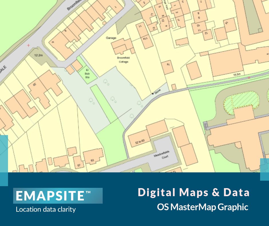
OS MasterMap Graphic is a simple image-only version of OS Mastermap Topography Layer. When you only need an image of Mastermap
Find out more: https://t.co/bKg6bybzwY
#OSmastermap #mastermaptopographylayer #topography

Over on the blog: Unlocking the power of OS Mastermap.
OS MasterMap is a highly detailed UK mapping database by Ordnance Survey (OS). Discover more about its features, applications and benefits for professionals. Click here to view: https://t.co/X4HZjViALR
#OSmastermap

OS MasterMap Graphic is a simple image-only version of OS Mastermap Topography Layer. When you only need an image of Mastermap
Find out more: https://t.co/bKg6bybzwY
#OSmastermap #mastermaptopographylayer #topography


thinkWhere | thinkWhich
Which #thinkWhere product is right for you?
#mapTrunk is our easy-to-use online map shop giving you quick access to a range of digital mapping services. Download @OrdnanceSurvey data at competitive prices.
👉 https://t.co/JryKGlax1h
#OSMasterMap

OS MasterMap Graphic is a simple image-only version of OS Mastermap Topography Layer, the most detailed, current and comprehensive map dataset of Great Britain.
Find out more: https://t.co/bKg6bybzwY
#OSmastermap #mastermaptopographylayer #topography
The OS MasterMap Imagery Layer® comprises the best available aerial image. Ideal for checking road markings, tree canopies or site entrances. Available as a traditional raster or as a web service. Find out more: https://t.co/bKg6bybzwY
#ariel #imagerylayer #osmastermap

At Emapsite we provide a huge range of digital maps in various scales and formats to cover your mapping needs. Find out more!
https://t.co/2VhB7k3v2M
#mapping #maps #osmastermap #ordnancesurvey #emapsite

Any @OrdnanceSurvey @GeoserverO buffs know the correct link to the "https://t.co/QeP6mnituk" which is defined in the #OSMastermap #SLD
(https://t.co/Q1l18w5fRa)

See the before and after of the Olympic Park in Stratford. This development was captured multiple times throughout the construction process in the OSMM Topography Layer.
Celebrating the 20th anniversary of the MasterMap Topography Layer: https://t.co/e5mCvVtmAw
#OSMasterMap
Looking back at our data from the last 20 years, we've compared different features which made up the landscape of Great Britain in 2001, and then in 2021.
Discover what the Topography Layer archive can tell us about our changing nation: https://t.co/n8G9uEt8Hy
#OSMasterMap
We're celebrating 20 years since we launched the OS MasterMap Topography Layer - the most detailed and geographically complete dataset of Great Britain.
See how it has been used over the last two decades:
https://t.co/V8rHEHvRXj
#OSMasterMap #DigitalMapping #SeeABetterPlace

Yes, this is about our work!
Read about how we used missing #GPS signals to build #3D #maps of #cities -
Thanks to our #ukriflf project's partner @OrdnanceSurvey #data (#OSMasterMap #OpenData API) we can build & evaluate accuracy of our #3DModel
https://t.co/NSYdbptxJP

'As well as using OS MasterMap information internally for our algorithms, we hope to use our results and the OS OpenData APIs in our app to generate a 3D representation.'
Find out more about this @UofGlasgow project from @lines_terry👉 https://t.co/u11J6zp6uu


#foss4guk2019 #FOSS4GUK Michael Gordon from @OrdnanceSurvey now talking about opening up #OSMasterMap


Great explanation by @maddiemoate about the #surveying and #cartography work of @OrdnanceSurvey to create and update the #OSMasterMap® often used by students in @Digimap4Schools and @ArcGISOnline incl #GPS and #GIS 07.29-14.10 @EYPPC_GA @GIS4Schools @geogologue
As part of @CBeebiesHQ’s programme Do You Know?, @maddiemoate visited our HQ to learn how maps are made🗺️
ICYMI catch up on @BBCiPlayer: https://t.co/948z1JgOcS


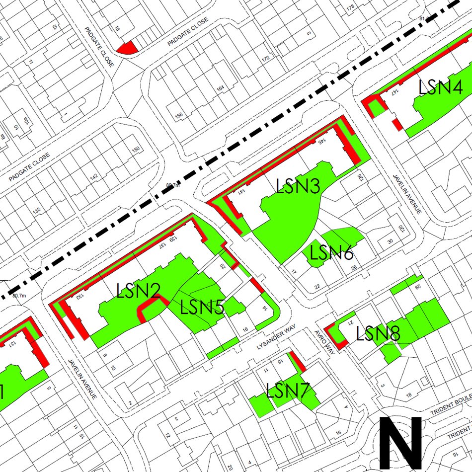
The Pioneer Group required new spatially accurate maps of 14 neighbourhoods using legacy data and an up-to-date base map.
Read more about how we achieved this for them.
#gis #datacapture #spatialanalysis #osmastermap
https://t.co/difdvo3GGa
Last Seen Hashtags on Sotwe
Most Popular Users

Elon Musk 
@elonmusk
240.1M followers

Barack Obama
@barackobama
119.3M followers

Donald J. Trump
@realdonaldtrump
111.6M followers

Cristiano Ronaldo
@cristiano
108.9M followers

Narendra Modi
@narendramodi
107M followers

Rihanna
@rihanna
97.3M followers

NASA
@nasa
92.1M followers

Justin Bieber
@justinbieber
90.6M followers

KATY PERRY
@katyperry
86.8M followers

Taylor Swift
@taylorswift13
80.6M followers

Lady Gaga
@ladygaga
72.1M followers

Kim Kardashian
@kimkardashian
69.4M followers

YouTube
@youtube
68.6M followers

Virat Kohli
@imvkohli
68.5M followers

Bill Gates
@billgates
63.4M followers

The Ellen Show
@theellenshow
62.5M followers

CNN
@cnn
61.9M followers

Neymar Jr
@neymarjr
61.1M followers

X
@x
60.9M followers

Selena Gomez
@selenagomez
59.9M followers