

Top Tweets for #Weathersynopsis

DWM SPECIAL UPDATE FOR WINTER RAINS DATED 22ND JAN, 2026| 7:30 AM
#Topic: Winter rainy conditions expected on Jan 25-27th,2026.
#Weathersynopsis:
==> Strong wintery conditions are expected to persist across southern peninsular India over the next 3 days. Dry continental northerly winds will maintain a vigorous winter-like state during this period.
==> Foggy weather accompanied by early morning misty conditions is likely to continue across the region throughout this timeframe.
==> Chances of winter rains are expected to return to Tamil Nadu towards the next weekend, particularly around 26th and 27th January 2026, as easterly winds become more active.
==> The interaction of mid level westerlies and low level easterlies likely to result isolated heavy to very heavy rains over coastal dts of TamilNadu. #Chennai also will get decent rains this time.
==> Farmers in the harvesting phase are advised to stay alert and take necessary precautions to safeguard their crops against these unseasonal winter showers.
#Disclosure:Please note that this is not an extreme or alarming event — the advisory is only to ensure basic readiness for the anticipated rainfall.
Stay tuned and connected with @deltarains on X for timely updates as the weather system evolves! 🌧️
Thanks & Regards
Hemachander R
Independent weather blogger
Email: [email protected]
#Disclaimer: This is purely my personal view and interpretation based on my own analysis.

DWM SPECIAL UPDATE FOR WINTER RAINS DATED 18TH JAN, 2026| 7:30 AM
#Topic: Wintery conditions at the peak, rains likely to return soon?
#Weathersynopsis:
==> Strong wintery conditions are expected to persist across southern peninsular India over the next 7–8 days. Dry continental northerly winds will maintain a vigorous winter-like state during this period.
==> Foggy weather accompanied by early morning misty conditions is likely to continue across the region throughout this timeframe.
==> Chances of winter rains are expected to return to Tamil Nadu towards the next weekend, particularly around 26th and 27th January 2026, as easterly winds become more active. Another spell of rain is also possible around the end of January.
==> Farmers in the harvesting phase are advised to stay alert and take necessary precautions to safeguard their crops against these unseasonal winter showers.
#Disclosure:Please note that this is not an extreme or alarming event — the advisory is only to ensure basic readiness for the anticipated rainfall.
Stay tuned and connected with @deltarains on X for timely updates as the weather system evolves! 🌧️
Thanks & Regards
Hemachander R
Independent weather blogger
Email: [email protected]
#Disclaimer: This is purely my personal view and interpretation based on my own analysis.

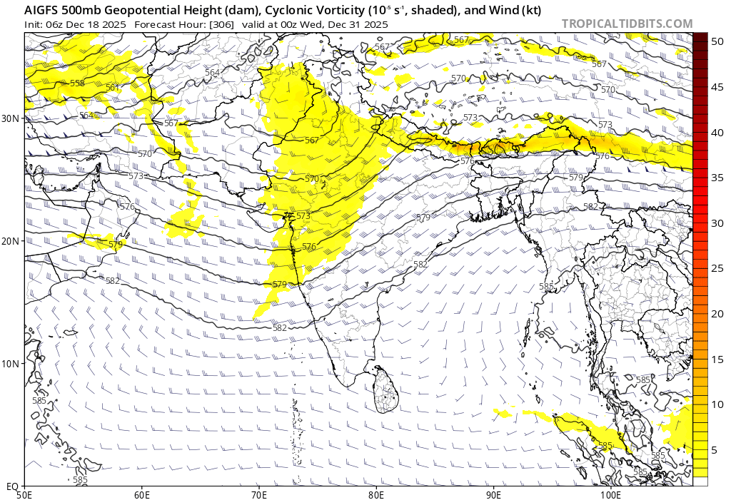
DWM SPECIAL UPDATE ABOUT MONTHEND RAINS DATED 18TH DEC, 2025
#Topic: Westerly trough & Easterlies interaction likely to bring rainy wave during Dec 29, 2025 -Jan 2nd, 2026.
#Weathersynopsis:
==> Under the influence of a strong Indian subcontinent ridge , another peak in wintery conditions is expected across India.
Peak-winter phase:
==> Southern peninsular India, including Tamil Nadu, is likely to experience its peak winter phase over the next 10 days. Hill stations in the ghats region, such as the Nilgiris, Ooty, Coonoor, Yercaud, Kodaikanal, and Valparai, may see freezing conditions with minimum temperatures dropping below 10°C. Interior districts could record dips to 16–19°C, while coastal areas may see 19–21°C.
Extended NEM Activity:
==> In the background of ongoing La Niña conditions and the arrival of planetary waves, an interaction between a westerly trough and easterlies is anticipated between December 28, 2025, and January 2, 2026.
==> This rainy wave could lead to an extension of Northeast monsoon activity into January 2026, with Chennai also facing rain chances around the month-end and New Year period.
==> Both the ECMWF and GFS AI-enhanced versions have begun indicating this potential rainy spell.
Stay tuned & connected with @deltarains on X for timely updates as the system evolves! 🌧️
Thanks & Regards
Hemachander R
Independent weather blogger
Email: [email protected]
#Disclaimer: This is purely my personal view and interpretation. Please do not bring other views from official agency or other private weather bloggers here. Understand that this is my own perspective, and I am ready to explain any queries regarding my post, not those of others.
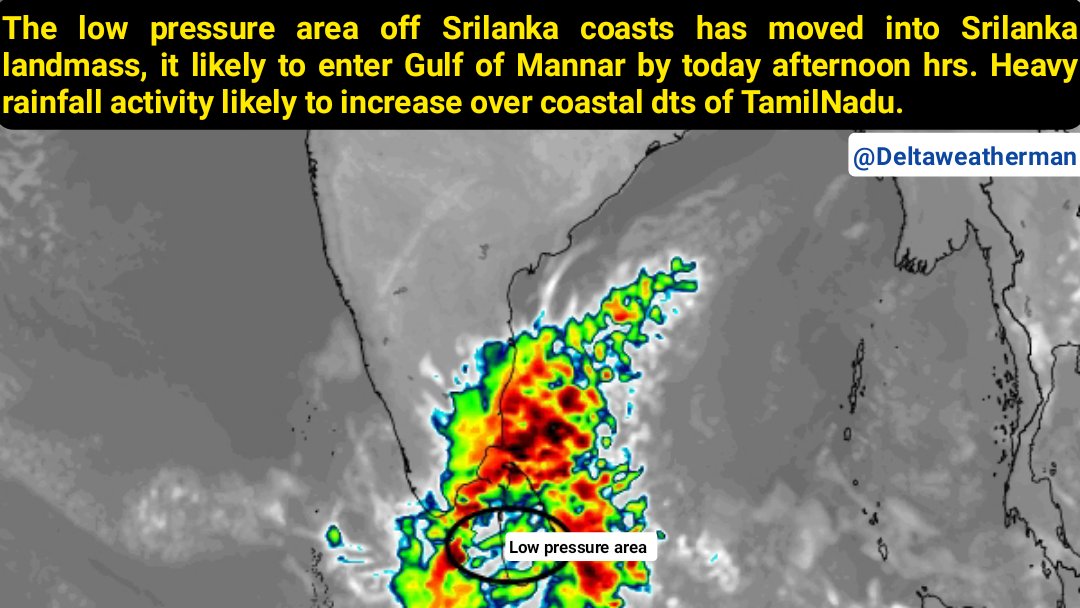
DWM NOWCAST WEATHER FOR 3RD ROUND OF NEM UPDATE -4| 17.11.2025| Time : 6:00 am
#TOPIC: LOW PRESSURE AREA LIKELY TO ENTER GOM WATERS
#Weathersynopsis
==> The low pressure area over Southwest Bay of Bengal coasts persist over Srilanka landmass. It very likely to enter Gulf of Mannar coasts during next few hours.
==> As the LPA moves into GOM, a strong convergence expected to fall off TamilNadu during next 36 hrs.
==> Coastal stretches of TamilNadu has received moderate to rather heavy rainfall, as low moves Gulf of Mannar monsoon rains expected to intensify further from today afternoon.
==> #Chennai #Thiruvallur & suburbs will see rainfall activity from afternoon hours.
============================
#Weatherforecast
Vigorous monsoon conditions expected during next 48 hrs.
Day 1 (17.11.2024) & Day 2 (18.11.2025)
==> Coastal dts of TamilNadu like #Thiruvallur, #Chennai, #Kanchipuram, #Chengalpet, #Villupuram, #Cuddalore, #Mayuladuthurai, #Nagapattinam, #Thiruvarur, #Ramanathapuram, #Thuthukudi, #Thirunelveli and #Kanyakumari dts likely to experience on and off heavy rains. Isolated places of coastal region may see very heavy rainfall.
==> Other dts #Thanjavur, #Pudhukottai, #Ranipet, #Vellore, #Thiruvanamalai, #Kallakuruchi, #Ariyalur, #Perambalur, #Trichy, #Sivagangai, #madurai, #virudhunagar likely to see rather heavy to heavy rainfall activity from today late afternoon/evening hours.
==> Western ghats & west interior dts will see gradual increase in rainfall activity from tomorrow.
Day 3 (19.11.2025) & Day 4 (20.11.2025)
==> As the low pressure area expected to move Comorin sea & Lakshadweep region. Third round of rains likely to continue till 20th Nov, especially western ghats & west interiors will see widespread rainfall activity on 19th & 20th Nov, 2025.
==> Coastal zone also expected to receive decent rainfall activity.
School holidays announcement:
#Pudhucherry & #Karaikal has declared holiday for Schools & Colleges today. Few other coastal dts of North TamilNadu likely to join in within next hour or so.
#Disclosure: Northeast Monsoon waking up, bringing active conditions with widespread moderate to heavy rains isolated very heavy spells across coastal Tamil Nadu, exactly what the season needs.
Stay tuned & connected with @deltarains on X for timely updates as the system evolves! 🌧️
Thanks & Regards
Hemachander R
Independent weather blogger
Email: [email protected]
#Disclaimer: This is purely my personal view and interpretation. Please do not bring other views from official agency or other private weather bloggers here. Understand that this is my own perspective, and I am ready to explain any queries regarding my post, not those of others.
#ChennaiRains #TNRains #Deltarains #NEM2025
DWM THIRD ROUND OF MONSOON SPELL UPDATE, DATED 14TH NOVEMBER, 2025
#Topic: Monsoon getting into Vigorous Phase during second half of November.
#WeatherSynopsis
==> A trough of low pressure associated with an easterly wave over the central parts of the south Bay of Bengal is likely to move toward the southwest Bay of Bengal during the next 48 hours.
==> It is expected to track across south Sri Lanka, the Gulf of Mannar, the Comorin Sea, and into the Lakshadweep Sea between November 16 and 20, 2025. There is a good possibility for this trough to emerge into a low-pressure area over the Gulf of Mannar/ Comorin Sea around November 17 or 18, 2025.
#WeatherForecast
Today's Weather (14.11.2025)
==> Scattered rainfall activity is likely over south Tamil Nadu and parts of the ghats, while dry weather is expected to prevail over north Tamil Nadu and other parts of the state today and tomorrow. (very isolated thunderstorm may occur at one or two places)
Third Round of NEM 2025
November 16, 2025
==> Moderate to rather heavy rains with isolated heavy falls are expected over #Mayiladuthurai, #Nagapattinam, #Thiruvarur, #Thanjavur, #Ramanathapuram, #Tuticorin, and #Karaikal districts.
==> #Chennai and other north coastal districts will see a gradual establishment of rainfall from late evening or afternoon hours.
November 17 and 18, 2025
==> Widespread heavy to very heavy rains are anticipated across coastal Tamil Nadu, including the districts of #Chennai, #Thiruvallur, #Kanchipuram, #Chengalpet, #Villupuram, #Cuddalore, #Mayiladuthurai, #Nagapattinam, #Thiruvarur, #Thanjavur, #Pudukkottai, #Ramanathapuram #Tuticorin, #Tirunelveli, and #Kanyakumari.
==> Interior districts will also experience an increase in widespread rainfall activity starting from November 17.
November 19 and 20, 2025
==> As the low moves toward the Lakshadweep region, pull-effect rains will comes to the action. North coastal areas, Cauvery Delta, south Tamil Nadu, interior districts, and the ghats are likely to receive widespread moderate to heavy rainfall.
#Conclusion
Overall, November 16–20 will mark the first best rainy period for most parts of Tamil Nadu during NEM2025.
What's Next?
==> Another low-pressure area is likely to develop over the southwest Bay of Bengal, potentially becoming a well-marked low or depression and bringing another spell of vigorous monsoon activity between November 21 and 25, 2025.
Back-to-back systems are expected to deliver a very good rainy period for Tamil Nadu between Nov 15 and 25th, 2025.
Cyclone at the End of November?
==> A development of low-pressure area in the last week over the south Andaman Sea could develop into a rain-bearing cyclonic storm or severe cyclonic storm, but it is too early to discuss this in detail.
==> One assurance is that western disturbances will not influence our systems until the first week of December, so the focus remains on North Tamil Nadu.
#Disclosure
==> This is a personal interpretation intended to create awareness not to bring panic. No alerts for extreme rains or flooding have been issued, and this should not be seen as hype but as an effort to demonstrate the science behind the emerging rainy wave patterns.
==> The northeast monsoon is waking up, delivering the active conditions the season requires, with November 16–20 promising very good monsoon rains.
Stay tuned and connected with @deltarains on X for timely updates as the system evolves! 🌧️
Thanks & Regards
Hemachander R
Independent Weather Blogger
Email: [email protected]
#Disclaimer: This is purely my personal view and interpretation. Please do not bring views from official agencies or other private weather bloggers here. This is my own perspective, and I am ready to explain any queries regarding my post, not those of others.
#ChennaiRains #Deltarains #ExcessNovember #Tamilnadurains #TNRains

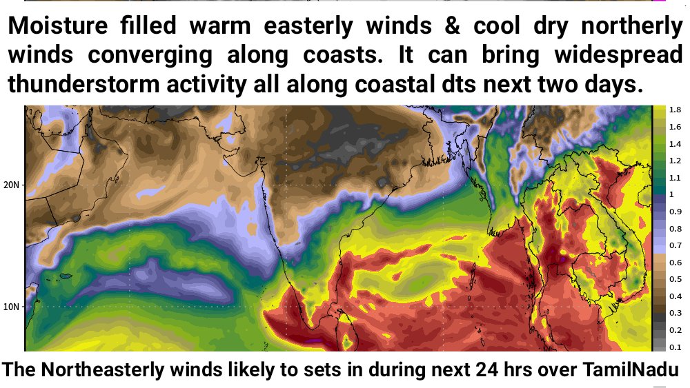
DWM DAILY WEATHER FORECAST DATED : NOV 10, 2025 | Time: 7 AM
#Weathersynopsis:
==> The full-fledged Northeasterly winds arriving TamilNadu during next 24 hours.
==> Due to the convergence of moisture-rich warm easterly winds and dry cold northerly winds, widespread rain is likely in coastal districts on November 11 and 12.
Today's Weather (10.11.2025)
==> The sky will remain generally cloudy. The strong presence of north wind (Vaadai Kattru) will be noticeable.
==> Scattered rain will start #Chennai and suburbs tonight. Widespread rain is possible for the next two days.
Day 1 (11.11.2025)
==> Intermittent moderate to rather heavy rain, with heavy rain at a few places in the north coastal and Cauvery Delta districts: #Thiruvallur, #Chennai, #Kanchipuram, #Chengalpattu, #Villupuram, #Cuddalore, #Mayiladuthurai, #Nagapattinam, #Tiruvarur, #Thanjavur, #Puducherry, and #Karaikal.
Day 2 (12.11.2025)
==> Intermittent moderate to rather heavy rain, with heavy rain at a few places in the Cauvery Delta and southern districts: #Mayiladuthurai, #Nagapattinam, #Tiruvarur, #Thanjavur, #Pudukkottai, #Ramanathapuram, #Thoothukudi, #Tirunelveli, and #Kanyakumari.
==> Over the next two days, widespread rain is expected in coastal districts and rain in a few places in interior districts.
#Note: Intense thunder and lightning will accompany the rain. The public and farmers are requested to stay cautious of lightning strikes. =======================================
Information for Farmers
1. Farmers in north coastal, Cauvery Delta, and southern districts: please postpone all agricultural activities on November 11 and 12.
2. Especially avoid fertilization, pest control during these two days.
3. Cauvery Delta districts will get rain-free windows on November 13, 14, and 15. Plan your field work during these gap days. Northern districts will enjoy four consecutive dry days: November 13, 14, 15, and 16 (except for unavoidable 20–30 minute showers in isolated places).
4. Farmers in southern districts waiting to sow dry-land crops under rain-fed conditions: good rain is expected on November 12, 14, 15, and 16.
5. No warning for fishermen at present. Northeast winds will blow slightly stronger over the sea; please venture out with caution.
#Disclosure: This is not an extreme or alarming event. It’s simply the Northeast Monsoon waking up, bringing active conditions with widespread moderate to heavy rains across coastal Tamil Nadu, exactly what the season needs.
Stay tuned & connected with @deltarains on X for timely updates as the system evolves! 🌧️
Thanks & Regards
Hemachander R
Independent weather blogger
Email: [email protected]
#Disclaimer: This is purely my personal view and interpretation. Please do not bring other views from official agency or other private weather bloggers here. Understand that this is my own perspective, and I am ready to explain any queries regarding my post, not those of others.
DWM Depression Update - 3 | October 21, 2025, 4:30 PM IST
#Topic: Developing Depression Likely to Stall Off Chennai Coasts?
#WeatherSynopsis:
==> A well marked low pressure area over Sri Lanka and the Southwest Bay of Bengal is expected to intensify into a depression off the North Tamil Nadu coast by tomorrow, October 22, 2025.
==> There is a slight chance of this system strengthening into a deep depression, but the likelihood of it becoming a cyclone is very low.
Track and Landfall Forecast:
==> The depression is projected to approach the North Tamil Nadu coast within the next 24 hours.
==> It is likely to stall off the coasts of North Tamil Nadu and South Andhra Pradesh, particularly near the Chennai-Nellore coastal stretch, on October 23 and 24, 2025.
==> This stalling scenario is highly probable, especially close to Chennai.
Weather Outlook for the Next 3-4 Days:
==> Extreme North Tamil Nadu, particularly the #Kanchipuram, #Chengalpet, #Chennai, #Thiruvallur (#KCCT) dts can expect significant weather activity over the next few days.
24-Hour Rainfall Forecast:
==> Intermittent moderate to heavy rainfall is expected across coastal Tamil Nadu. Entire North TamilNadu, Cauvery Delta Zone & parts of South TamilNadu will see widespread rainfall activity today till tomorrow morning.
==> Rainfall is likely to intensify starting tonight and into the early morning hours of October 22, 2025.
#Impact:
1. School and college students may see extended Diwali holidays due to the anticipated rainfall.
2. Water stagnation in low lying areas & city region.
3.Farming activities & harvest will get impacted.
4. Heavy traffic issues expected at #Chennai & suburbs due to heavy rains & diwali returning peoples..
Stay tuned for updates and follow @Deltarains for the latest weather insights!
Thanks & Regards
Hemachander R
#ChennaiRains #Deltarains #RedAlert #TNRains #NEM2025
DWM ONSET SPECIAL UPDATE
Topic: Northeast Monsoon Onset and First Round of Rains 15th to 20th Oct, 2025
#Weathersynopsis:
Northeast Monsoon Onset:
==> Northeasterly winds are expected to strengthen over Tamil Nadu within the next 48 hours, setting the stage for increased rainfall activity along coastal areas. Conditions are favorable for the official onset of the Northeast Monsoon on Oct 16, 2025.
Weather System Development:
==> A cyclonic circulation is likely to form over the Comorin Sea and adjoining areas within the next 48 hours. With the support of Equatorial Rossby Wave this system is expected to develop into a low-pressure area over Lakshadweep and adjoining southeast Arabian Sea around October 18–19, 2025.
Weather Forecast for the First Round of Rains (October 15–21, 2025):
1. Duration
The onset and initial phase of rainfall are expected to span 6-7 days, from October 15 to October 20, 2025.
2. Peak Rainfall Activity:
Widespread rainfall is anticipated on October 17 and 18, 2025, impacting both coastal and interior districts of Tamil Nadu.
3. Rainfall Intensity:
The first round of rains is expected to be harmless and pleasant, with no indications of extreme or destructive weather events.
4. Coastal Districts:
Impactful areas: #Chennai, #Thiruvallur, #Kanchipuram, #Chengalpet, #Villupuram, #Puducherry, #Cuddalore, #Mayiladuthurai, #Karaikal, #Nagapattinam, #Thiruvarur, #Thanjavur, #Pudhukottai, #Ramanathapuram, #Thoothukudi, #Tirunelveli, and #Kanyakumari.
Rainfall Timing: Expect early morning to forenoon showers, particularly between 3 AM and 3 PM
5. Interior Districts:
Impactful areas: #Ranipet, #Vellore, #Tiruppathur, #Thiruvannamalai, #Kallakuruchi, #Krishnagiri, #Dharmapuri, #Salem, #Namakkal, #Karur, #Perambalur, #Ariyalur, #Trichy, #Sivagangai, #Virudhunagar, #Tenkasi, #Theni, #Tirunelveli, #Dindigul, #Madurai, #Coimbatore, #Erode, #Nilgiris, and #Tiruppur.
Rainfall Timing: Evening and nighttime thunderstorm activity is expected.
6.Regional Highlights:
==> Cauvery Delta Zone, Interior, and South Tamil Nadu are likely to experience heavy rainfall on October 17 and 18, 2025.
==> North Coastal, North Interior, West Interior, and Southern Districts**: These regions will also receive good rainfall during this period.
Impact Assessment:
1. The rainfall is not expected to disrupt daily life significantly.
2.However, harvest farmers and/festival vendor may face challenges due to the wet conditions.
3. Clear & bright sunshine expected over entire TamilNadu.
This forecast indicates a promising start to the Northeast Monsoon, bringing decent rains to Tamil Nadu without major disruptions.
For further details & updates follow @deltarains regularly.
Thanks & Regards
Hemachander R


DWM Daily Weather Forecast dated 11th Oct, 2025:
==> As of 8:30 AM today (11.10.2025), Marandahalli in Dharmapuri district recorded 18 cm of very heavy rainfall.
#Weathersynopsis:
==> Due to variations of wind instability in the atmosphere over Tamil Nadu, convective thunderstorms are expected to intensify today across the state.
==> During the day, clear skies with warm conditions are likely. In the evening, night, or midnight, convective thunderstorms are expected to intensify.
Coastal Districts:
==> In Tamil Nadu’s coastal districts, including #Chennai, #Thiruvallur, #Kanchipuram, #Chengalpattu, #Viluppuram, #Cuddalore, #Mayiladuthurai, #Nagapattinam, #Thiruvarur, #Thanjavur, #Pudukkottai, #Ramanathapuram, #Thoothukudi, and #Tirunelveli, isolated places may experience rain with thunder and lightning in the afternoon/evening, while widespread rain is expected in many areas during the night/midnight.
Southern Districts:
==> In southern districts such as #Tirunelveli, #Tenkasi, #Theni, #Dindigul, #Madurai, #Virudhunagar, #Sivagangai, and #Pudukkottai, widespread heavy rain with thunder and lightning is expected in the evening/night.
Interior & Western Districts:
==> In districts including #Coimbatore, #Nilgiris, #Erode, #Tiruppur, #Karur, #Namakkal, #Salem, #Dharmapuri, #Krishnagiri, #Tirupathur, #Tiruvannamalai, #Kallakurichi, #Perambalur, and #Tiruchirappalli, heavy rain with thunder and lightning is expected in the evening/night.
Overall Today:
Across Tamil Nadu, there is a high chance of heavy rainfall accompanied by thunder and lightning in the evening/night on 11.10.2025.
Thanks & Regards
Hemachander R
#Thunderstorms #Interiorrains #lightning #thunders

DWM Special Update dated Sept 23, 2025
Topic: Depression Likely to Usher in Farewell Phase of Southwest Monsoon
#WeatherSynopsis:
==> A fresh low-pressure area is expected to form over the Northwest Bay of Bengal around September 25, 2025. It is likely to intensify into a depression and cross the coasts between South Odisha and North Andhra Pradesh by September 26, 2025.
==> The system is expected to move across #Odisha, #AndhraPradesh, #Telangana, #MadhyaPradesh , and #Maharashtra between September 26 and 28, 2025.
#WeatherForecast:
==> The southwest monsoon, statistically spanning from June 1 to September 30, is likely to see its final active phase with the development of this depression.
==> States including #AndhraPradesh , #Odisha, #Telangana, #MadhyaPradesh , #Maharashtra, #Goa, #Karnataka, #Kerala, and parts of #Gujarat are expected to experience vigorous monsoon conditions from September 25 to 29, 2025.
==> The Cauvery catchment area and the Western Ghats of Tamil Nadu are also likely to witness widespread rainfall during this period.
==> Convective thunderstorm activity is expected to remain active over coastal Tamil Nadu for the next three days. As the southwest monsoon intensifies, thunderstorm activity is likely to subside concurrently.
Thanks & Regards
Hemachander R

DWM Daily Weather Forecast: Sept 22, 2025
#WeatherSynopsis:
==> A fresh low-pressure area is expected to form over the North Bay of Bengal within the next 72 hours. Influenced by this system, favorable wind convergence will bring conventional thunderstorm activity to North Tamil Nadu and delta coasts over the next three days.
==> Districts including #Chennai, #Thiruvallur, #Kanchipuram, #Chengalpet, #Villupuram, #Cuddalore, #Mayiladuthurai, #Nagapattinam, #Thiruvarur, #thanjavur, #Pudhukottai, #Sivagangai, #Dindigul, #Trichy, #ariyalur, #perambalur, #Kallakuruchi, #Thiruvannamalai, #Ranipet, #Vellore, #Tirupathur, and #Krishnagiri are likely to experience evening, night, and late-night thunderstorms during this period.
==> Conventional thunderstorm rainfall activity is expected to gradually decrease starting Sept 25, 2025 as SWM revives back over many parts of India.
Thanks & Regards
Hemachander R

DWM SPECIAL UPDATE DATED 11TH SEPT, 2025
TOPIC: THUNDERSTORMS PICKING UP IN TAMILNADU, CHENNAI HEAVY RAIN CHANCES.
#Weathersynopsis:
==> The Cyclonic circulation persists over west central Bay of Bengal off Andhra Pradesh coasts.
==> Under it's influence, wind convergence falls over North TamilNadu region from today.
#Weatherforecast:
==> Widespread conventional thunderstorms rainfall activity expected over most parts of TamilNadu during next 24 hrs.
==> Coastal dts like #Chennai #Thiruvallur #Chengalpet #Kanchipuram #Villupuram #Cuddalore #Mayiladuthurai #Nagapattinam #Thiruvarur #Thanjavur #Pudhukottai #Ramanathapuram #Thuthukudi dts likely to see widespread thunderstorm rainfall activity today evening & night hours.
==> One or two places of #Pudhukottai #Mayiladuthurai #Cuddalore #Pudhuchery #Villupuram dts may see intense heavy rains in 40-60 minutes period.
==> Interior dts like #Tenkasi #Viruthunagar #Madurai #Dindugal #Trichy #Karur #Erode #Salem #Dhrampuri #Krishnagiri #Thirupatthur #Vellore #Ranipet #Thiruvanamazhai #Kallakuruchi #Permabalur #Ariyalur dts also will see decent thunderstorms today.
==> #Chennai & suburbs have conventional thunderstorm rains next three days.
Overall great thunderstorm blast ahead for many dts of TamilNadu.
Thanks & Regards
R.Hemachander
(Deltaweatherman)

DWM DAILY WEATHER FORECAST DATED 9TH SEPT, 2025
Detailed YouTube link:
https://t.co/VtG3nfDBKD
#Weathersynopsis:
==> The atmospheric wind instable conditions observed over southern peninsular India.
#Weatherforecast:
==> Clear and hot sunshine conditions expected during day time with above normal temperature.
==> A strong wind instability likely to lead massive conventional thunderstorm activity over interiors districts today & tomorrow especially during late evening & night hours.
==> Especially west & interior dts like #Thirunelveli #Thuthukudi (west), #Tenkasi #Theni #Madurai #Viruthunagar #Sivagangai #Pudhukottai #Dindugal #Coimbatore #Nilgiris #Tiruppur #Erode #Karur #Trichy #Ariyalur #Perambalur #Namakkal #Kallakuruchi #Salem #Dharmapuri #Krishnagiri #Thiruppathur #Thiruvanamalai #Vellore and #Ranipet dts will see widespread thunderstorm rainfall activity.
==> Very isolated places of coastals may see light thunderstorm activity.
Note: Intense lightning & thunderstorms expected during rainy hours.
Thanks & Regards
Hemachander R

DWM CHENNAI SPECIAL UPDATE FOR TODAY THUNDERSTORMS DATED 2ND SEPT, 2025
#Weathersynopsis:
==> A low pressure area has formed over Northwest Bay of Bengal. Under it's influence, favourable wind convergence falls over extreme North TamilNadu by today night hrs.
#Weatherforecast:
==> #Chennai and adjoining districts like #Thiruvallur #Kanchipuram #Chengalpet #Ranipet #Vellore #Thiruvanamalai #Villupuram #Pudhucherry & #Cuddalore falls under wind convergence & favourable atmospheric conditions to lead thunderstorm rainfall activity today evening/night hours.
==> #Chennai & suburbs can expect rather heavy to heavy thunderstorm rains between 7 and 11 pm.
Note: This rains won't repeat any cloudburst kind of pattern.
Thanks & Regards
Hemachander R
#ChennaiRains
#thunderstorm

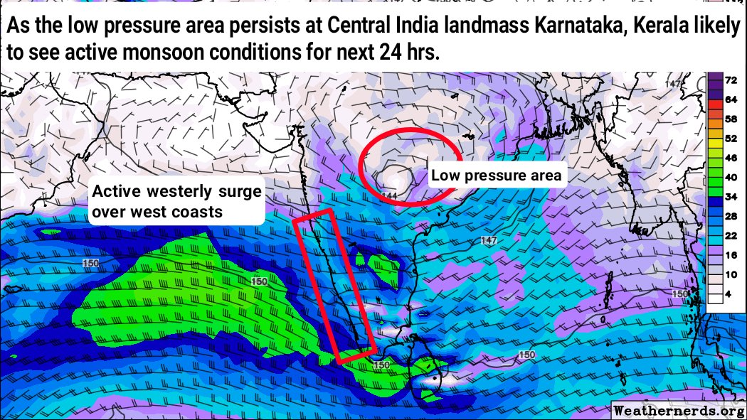
DWM DAILY WEATHER FORECAST DATED 29TH AUG, 2025
#Weathersynopsis:
==> The low pressure area persists over central India (Southeast Madhya Pradesh and neighborhood).
==> It likely to keep the active monsoon conditions over west coasts and parts of central India.
#Weatherforecast:
==> #Kerala & #Karnataka especially western ghats region likely to see widespread heavy rainfall activity with active monsoon conditions for next 24 hrs.
==> From tomorrow, gradual reduction of monsoon conditions expected at west coasts. However, moderate showers likely to continue for another 2-3 days.
==> Western ghats areas of #Nilgiris especially #Bandalur, #Devala, #Avalanche, #Gudalur region & #Coimbatore dt #Chinnakallur #Valparai region likely to see heavy rainfall activity today.
==> Palakkad pass #Kinathukedavu #Negamam #Aanamalai #Palladam #Udumalaipettai surroundings likely to see passing showers today as well.
==> Mostly dry weather expected over plains area of #Tamilnadu. Isolated places of coastal region likely to see passing thunder showers during late evening & night hours.
Thanks & Regards
Hemachander R
Deltaweatherman
DWM DAILY WEATHER FORECAST DATED 28TH AUG, 2025
#Weathersynopsis:
==> The low pressure area persists over landmass of north #Andhrapradesh and #Odisha.
==> It likely to bring active monsoon conditions over west coasts and parts of central India.
#Weatherforecast:
==> Vigorous monsoon conditions with heavy to very heavy rains expected over parts of #Maharastra #Telangana and #Karnataka states today. #Kerala and north #Andhrapradesh likely to see active monsoon conditions with heavy rains.
==> #Kerala & #Karnataka especially western ghats region likely to see widespread heavy rainfall activity today.
==> Mostly dry weather expected over #Tamilnadu. Isolated places of coastal region like #Chennai #Thiruvallur #Nagapattinam likely to see passing thunder showers during late evening & night hours.
Thanks & Regards
Hemachander R
Deltaweatherman

DWM SPECIAL FORECAST ABOUT EXTREME RAINY EVENT DATED 26TH AUG, 2025
Topic: Developing low pressure area & associated multi cyclonic circulation can bring extreme rains to Himachal & Andhra Pradesh.
#Weathersynopsis:
==> Under the influence of cyclonic circulation, a fresh low pressure area likely to develop over Northwest Bay of Bengal off Odisha coasts during next 24 hrs.
==> The trough line from the cyclonic circulation runs through #Himachalpradesh & #Jammukashmir and brings temporary vortex kind of pattern for next 12-18 hrs.
#Weatherforecast:
==> The border region of #Jammukashmir & #Himachalpradesh places like #Jammu #Udhampur #Samba #Bilaur surrounding likely to receive very heavy to extremely heavy rains for next 12 hrs.
==> This can lead localized flash floods by today evening hours. Jammu peoples are advised to stay safe.
==> On the other side, developing LPA will bring vigorous monsoon conditions over North #Andhrapradesh especially #Vishakapattinam surroundings can get very heavy rains today. Vizag city also can see flash flood situation at low lying areas today.
==> Southwest monsoon activity gradually expected to revive at #Kerala #Karnataka from today evening hours. Next three days active monsoon conditions were expected at west coasts. Especially western ghats can catch decent rains till 29th August, 2025.
Thanks & Regards
Hemachander R

Vigorous southwest monsoon conditions remains there for next 48 hrs!
#Weathersynopsis
==> The well marked low pressure area over Northwest Bay of Bengal off Odisha coasts likely to become a Depression during next 12-18 hrs over the same region.
==> Under it's influence, first round of vigorous southwest monsoon remains continue for next 48 hrs.
============================
#Weatherforecast
==> Heavy to very heavy rains with isolated extremely heavy rains expected over #Karnataka especially dts like #Dakshinakannada #Udupi #Chikkamagaluru #Hassan and #Kodagu dts & #Kozhikode #Wayanad #Idukki #Kannur #Thrissur #Pathanamthitta dts of Kerala & western ghats areas of #Nilgiris #Coimbatore.
==> Vigorous monsoon conditions expected till early morning hours of 31st may, 2025.
==> Monsoon activity likely to reduce gradually from 31st may, 2025.
#keralarains #Swm2025 #Ghatsrains

RED ALERT CATEGORY 2 WARNING TO DELTA DISTRICTS
#weathersynopsis
==> A well marked low pressure area has intensified into a Depression over south central Bay of Benga by today (25.11.2024) morning 5:30 am. It likely to intensify further into a deep depression during next 24 hrs.
==> This system likely to move north-northwest direction along with Srilanka coasts and stall near Srilanka & delta coasts for 36-48 hrs.
#weatherforecast
#Day1 (25.11.2024)
==> Delta districts expected to see increase in rainfall activity from today late evening or night. Heavy rains likely to starts from today night hrs.
#Day2 ( 26.11.2024) & #Day3 (27.11.2024)
==> Widespread heavy to very heavy rains with many extreme rainfall activity likely to be there at #Nagappatinam, #Karaikal, #Mayiladuthurai, #Cuddalore, #Thiruvaur & #Thanjavur dts.
==> Isolated places of #Nagapattinam #Thiruvarur #Mayiladuthurai & #Karaikal dts likely to see exceptionally heavy rains (<40 cms) between Nov 26th Night hours to Nov 28th early morning hours.
==> #Chennai #Tjiruvallur #Kanchipuram #Chengalpet #Villupuram #Pudhucherry likely to see widespread heavy to very heavy rainfall & isolated places may receive extremely heavy rains (around 20cms). Chennai rains likely to pickup from 26th late evening/night onwards.
#Day4 (28.11.2024) & #Day5 (29.11.2024)
==> #Chennai #Tjiruvallur #Kanchipuram #Chengalpet #Villupuram #Pudhucherry likely to see widespread heavy to very heavy rainfall & isolated places may receive extremely heavy rains (around 20cms). Chennai rains likely to pickup from 26th late evening/night onwards.
==> Widespread heavy to very heavy rains with isolated extreme rains (20cms) likely to continue at delta region.
==> Overall rains continue till Dec 1st, 2024.
Note: Delta people need not to get panic, it's time to do final preparation for the rains.
#Chennairains #Deltarains #Northeastmonsoon #NEM2024
Thanks & Regards
Hemachander R
Detailed weather forecast dated on 20th Oct, 2024
#Weathersynopsis
1. The low pressure area has weakened over east central Arabian sea and neighborhood.
2. The weak cyclonic circulation persists off north Tamil Nadu coasts. Under the influence, mid level instability persisting at southern peninsular India.
3. A fresh low pressure area likely to develop over north Andaman & East Central Bay of Bengal during next 24 hrs. It will intensify further and become Cyclonic storm during subsequent 72 hrs. It will cross the coasts between north Andhra Pradesh and West bengal coasts by late night hours of 25th oct, 2024.
=======================================
*Thunderstorms kind of rains likely to continue*
Day 1 (21.10.2024) To Day 4 (24.10.2024)
==> Intense thunderstorm & lightning activity with isolated heavy rains likely to continue over Interior & coastals during night/late night & morning hours.
=======================================
*Odisha cyclone likely to bring southwest monsoon kind of weather temporarily for few days*
Day 5 (25.10.2024) To Day 8 (28.10.2024)
==> Day time expected to be clear and pleasant sunshine. Thunderstorms rainfall activity will be there at interiors during evening/night hours. Storms likely to move towards coastals during late night hours.
Thanks & Regards
Hemachander R aka Deltaweatherman
Last Seen Hashtags on Sotwe
ห้วยโป่ง
Seen from Thailand
minichat
Seen from Germany
minichat()**************************()filter:native_video
carbj
Seen from Turkey
pieshowdown
Seen from Canada
AnushkaShetty
Seen from India
togetherinourdivesity
Seen from Spain
lesbian #lactation
Seen from Turkey
privatetours
Seen from Korea
anxiouspanda
Seen from Turkey
Trends for you
Most Popular Users

Elon Musk 
@elonmusk
241.7M followers

Barack Obama
@barackobama
119M followers

Cristiano Ronaldo
@cristiano
114.6M followers

Donald J. Trump
@realdonaldtrump
111.9M followers

Narendra Modi
@narendramodi
107.2M followers

Rihanna
@rihanna
98.7M followers

NASA
@nasa
92.4M followers

Justin Bieber
@justinbieber
91.8M followers

KATY PERRY
@katyperry
90.1M followers

Taylor Swift
@taylorswift13
84M followers

Lady Gaga
@ladygaga
75.5M followers

Virat Kohli
@imvkohli
73.5M followers

Kim Kardashian
@kimkardashian
70.9M followers

YouTube
@youtube
68.8M followers

Neymar Jr
@neymarjr
66.5M followers

Bill Gates
@billgates
65.3M followers

Selena Gomez
@selenagomez
63.1M followers

The Ellen Show
@theellenshow
62.3M followers

CNN
@cnn
61.8M followers

X
@x
60.7M followers