

Top Tweets for #mimaropa

DICT Brings Digital Opportunities Through Connectivity, Skills, and Services Closer to Palawan Communities
Read full press release here: https://t.co/OcIkj3vVOe
#DICT #MIMAROPA #DigitalTransformation #DigitalBayanihan #BagongPilipinas


(1) TY #KALMAEGI (#31W, #TinoPH) reintensified and developed a banding eye this morning after leaving #Mimaropa... With above-normal SST and good outflow towards the west... KALMAEGI may reach an intensity of 165-175 km/h (90-95 kt) tomorrow...
🌀 Expected landfall:
#QuangNgai or #GiaLai, tomorrow night or Friday early morning
Over 300 mm of rainfall can be expected along the path of KALMAEGI... Residents in these regions are advised to take precautions ASAP...
(2) TD #32W (pre-#FUNGWONG, pre-#UwanPH) will intensify significantly over the Philippine Sea in the coming days... The conditions are very favourable and a number of models suggest rapid intensification... potentially bringing the intensity up to top-tier TY / SuperTY strength... We anticipate a peak intensity of over 100 kt (185 km/h)...
32W is forecast to track NW, then WNW along the southern periphery of the steering ridge... Landfall in #Luzon is highly likely on Sunday night or Monday morning...
Note that some AI models suggest a more southerly track (moving more W after the cyclone crosses 135E longitude)...
There is a higher chance for landfall in #Aurora or #Isabela... but it depends on the strengths of the storm itself and the STR cells... Adjustment to the forecast is still possible...
Residents in northern #Philippines are advised to closely monitor #32W as it could become one of the strongest storms in the region this year... It is important to prepare early...
[PS, You may follow our Telegram (https://t.co/ThUI7XDr3C) for updates on new posts, as well as notifications about JMA upgrades/downgrades and changes to TC signals in the region]
![ptccfeed's tweet photo. (1) TY #KALMAEGI (#31W, #TinoPH) reintensified and developed a banding eye this morning after leaving #Mimaropa... With above-normal SST and good outflow towards the west... KALMAEGI may reach an intensity of 165-175 km/h (90-95 kt) tomorrow...
🌀 Expected landfall:
#QuangNgai or #GiaLai, tomorrow night or Friday early morning
Over 300 mm of rainfall can be expected along the path of KALMAEGI... Residents in these regions are advised to take precautions ASAP...
(2) TD #32W (pre-#FUNGWONG, pre-#UwanPH) will intensify significantly over the Philippine Sea in the coming days... The conditions are very favourable and a number of models suggest rapid intensification... potentially bringing the intensity up to top-tier TY / SuperTY strength... We anticipate a peak intensity of over 100 kt (185 km/h)...
32W is forecast to track NW, then WNW along the southern periphery of the steering ridge... Landfall in #Luzon is highly likely on Sunday night or Monday morning...
Note that some AI models suggest a more southerly track (moving more W after the cyclone crosses 135E longitude)...
There is a higher chance for landfall in #Aurora or #Isabela... but it depends on the strengths of the storm itself and the STR cells... Adjustment to the forecast is still possible...
Residents in northern #Philippines are advised to closely monitor #32W as it could become one of the strongest storms in the region this year... It is important to prepare early...
[PS, You may follow our Telegram (https://t.co/ThUI7XDr3C) for updates on new posts, as well as notifications about JMA upgrades/downgrades and changes to TC signals in the region]](https://pbs.twimg.com/media/G4_4L8ybYAAvx2S.jpg)
![ptccfeed's tweet photo. (1) TY #KALMAEGI (#31W, #TinoPH) reintensified and developed a banding eye this morning after leaving #Mimaropa... With above-normal SST and good outflow towards the west... KALMAEGI may reach an intensity of 165-175 km/h (90-95 kt) tomorrow...
🌀 Expected landfall:
#QuangNgai or #GiaLai, tomorrow night or Friday early morning
Over 300 mm of rainfall can be expected along the path of KALMAEGI... Residents in these regions are advised to take precautions ASAP...
(2) TD #32W (pre-#FUNGWONG, pre-#UwanPH) will intensify significantly over the Philippine Sea in the coming days... The conditions are very favourable and a number of models suggest rapid intensification... potentially bringing the intensity up to top-tier TY / SuperTY strength... We anticipate a peak intensity of over 100 kt (185 km/h)...
32W is forecast to track NW, then WNW along the southern periphery of the steering ridge... Landfall in #Luzon is highly likely on Sunday night or Monday morning...
Note that some AI models suggest a more southerly track (moving more W after the cyclone crosses 135E longitude)...
There is a higher chance for landfall in #Aurora or #Isabela... but it depends on the strengths of the storm itself and the STR cells... Adjustment to the forecast is still possible...
Residents in northern #Philippines are advised to closely monitor #32W as it could become one of the strongest storms in the region this year... It is important to prepare early...
[PS, You may follow our Telegram (https://t.co/ThUI7XDr3C) for updates on new posts, as well as notifications about JMA upgrades/downgrades and changes to TC signals in the region]](https://pbs.twimg.com/media/G4_4L8wakAA8GCv.jpg)
(1) Deep convection of TY #KALMAEGI (#31W, #TinoPH) is becoming colder again after leaving #Panay and entering the Sulu Sea... KALMAEGI is expected to cross #Mimaropa overnight with an intensity of about 70 kt or 130 km/h (10-min)...
KALMAEGI will be passing over unusually warm waters in the 2-3 days... Supported by upper level divergence... the storm is forecast to reintensify before hitting #Vietnam... potentially reaching 85-90 kt (155-165 km/h) on Thursday...
Landfall in #QuangNgai / #GiaLai / #DakLak Province is likely on Thursday night or Friday early morning...
(2) TD #32W (pre-#FUNGWONG or pre-#UwanPH) (E of #Yap) is expected to gain strength steadily over the very warm waters of the Philippine Sea in the next few days... Environmental conditions are very favourable... Rapid intensification is possible, which could bring this system up to 90+ kt (165+ km/h)... The chance of it becoming a Super Typhoon is not low...
The subtropical ridge will remain strong and stable for the next 4-5 days... 32W will move WNW towards #Luzon... with landfall anticipated late Sunday or early Monday...
Residents in northern #Philippines are advised to closely monitor #32W as it could become one of the strongest storms in the region this year... It is important to prepare early...
(SST anomaly image from JMA)
[PS, You may follow our Telegram (https://t.co/ThUI7XDr3C) for updates on new posts, as well as notifications about JMA upgrades/downgrades and changes to TC signals in the region]
![ptccfeed's tweet photo. (1) Deep convection of TY #KALMAEGI (#31W, #TinoPH) is becoming colder again after leaving #Panay and entering the Sulu Sea... KALMAEGI is expected to cross #Mimaropa overnight with an intensity of about 70 kt or 130 km/h (10-min)...
KALMAEGI will be passing over unusually warm waters in the 2-3 days... Supported by upper level divergence... the storm is forecast to reintensify before hitting #Vietnam... potentially reaching 85-90 kt (155-165 km/h) on Thursday...
Landfall in #QuangNgai / #GiaLai / #DakLak Province is likely on Thursday night or Friday early morning...
(2) TD #32W (pre-#FUNGWONG or pre-#UwanPH) (E of #Yap) is expected to gain strength steadily over the very warm waters of the Philippine Sea in the next few days... Environmental conditions are very favourable... Rapid intensification is possible, which could bring this system up to 90+ kt (165+ km/h)... The chance of it becoming a Super Typhoon is not low...
The subtropical ridge will remain strong and stable for the next 4-5 days... 32W will move WNW towards #Luzon... with landfall anticipated late Sunday or early Monday...
Residents in northern #Philippines are advised to closely monitor #32W as it could become one of the strongest storms in the region this year... It is important to prepare early...
(SST anomaly image from JMA)
[PS, You may follow our Telegram (https://t.co/ThUI7XDr3C) for updates on new posts, as well as notifications about JMA upgrades/downgrades and changes to TC signals in the region]](https://pbs.twimg.com/media/G46hwc4bQAEy7qf.jpg)
![ptccfeed's tweet photo. (1) Deep convection of TY #KALMAEGI (#31W, #TinoPH) is becoming colder again after leaving #Panay and entering the Sulu Sea... KALMAEGI is expected to cross #Mimaropa overnight with an intensity of about 70 kt or 130 km/h (10-min)...
KALMAEGI will be passing over unusually warm waters in the 2-3 days... Supported by upper level divergence... the storm is forecast to reintensify before hitting #Vietnam... potentially reaching 85-90 kt (155-165 km/h) on Thursday...
Landfall in #QuangNgai / #GiaLai / #DakLak Province is likely on Thursday night or Friday early morning...
(2) TD #32W (pre-#FUNGWONG or pre-#UwanPH) (E of #Yap) is expected to gain strength steadily over the very warm waters of the Philippine Sea in the next few days... Environmental conditions are very favourable... Rapid intensification is possible, which could bring this system up to 90+ kt (165+ km/h)... The chance of it becoming a Super Typhoon is not low...
The subtropical ridge will remain strong and stable for the next 4-5 days... 32W will move WNW towards #Luzon... with landfall anticipated late Sunday or early Monday...
Residents in northern #Philippines are advised to closely monitor #32W as it could become one of the strongest storms in the region this year... It is important to prepare early...
(SST anomaly image from JMA)
[PS, You may follow our Telegram (https://t.co/ThUI7XDr3C) for updates on new posts, as well as notifications about JMA upgrades/downgrades and changes to TC signals in the region]](https://pbs.twimg.com/media/G46hwc1bcAEMPq6.png)
![ptccfeed's tweet photo. (1) Deep convection of TY #KALMAEGI (#31W, #TinoPH) is becoming colder again after leaving #Panay and entering the Sulu Sea... KALMAEGI is expected to cross #Mimaropa overnight with an intensity of about 70 kt or 130 km/h (10-min)...
KALMAEGI will be passing over unusually warm waters in the 2-3 days... Supported by upper level divergence... the storm is forecast to reintensify before hitting #Vietnam... potentially reaching 85-90 kt (155-165 km/h) on Thursday...
Landfall in #QuangNgai / #GiaLai / #DakLak Province is likely on Thursday night or Friday early morning...
(2) TD #32W (pre-#FUNGWONG or pre-#UwanPH) (E of #Yap) is expected to gain strength steadily over the very warm waters of the Philippine Sea in the next few days... Environmental conditions are very favourable... Rapid intensification is possible, which could bring this system up to 90+ kt (165+ km/h)... The chance of it becoming a Super Typhoon is not low...
The subtropical ridge will remain strong and stable for the next 4-5 days... 32W will move WNW towards #Luzon... with landfall anticipated late Sunday or early Monday...
Residents in northern #Philippines are advised to closely monitor #32W as it could become one of the strongest storms in the region this year... It is important to prepare early...
(SST anomaly image from JMA)
[PS, You may follow our Telegram (https://t.co/ThUI7XDr3C) for updates on new posts, as well as notifications about JMA upgrades/downgrades and changes to TC signals in the region]](https://pbs.twimg.com/media/G46hwcqbMAADjXv.jpg)
![ptccfeed's tweet photo. (1) Deep convection of TY #KALMAEGI (#31W, #TinoPH) is becoming colder again after leaving #Panay and entering the Sulu Sea... KALMAEGI is expected to cross #Mimaropa overnight with an intensity of about 70 kt or 130 km/h (10-min)...
KALMAEGI will be passing over unusually warm waters in the 2-3 days... Supported by upper level divergence... the storm is forecast to reintensify before hitting #Vietnam... potentially reaching 85-90 kt (155-165 km/h) on Thursday...
Landfall in #QuangNgai / #GiaLai / #DakLak Province is likely on Thursday night or Friday early morning...
(2) TD #32W (pre-#FUNGWONG or pre-#UwanPH) (E of #Yap) is expected to gain strength steadily over the very warm waters of the Philippine Sea in the next few days... Environmental conditions are very favourable... Rapid intensification is possible, which could bring this system up to 90+ kt (165+ km/h)... The chance of it becoming a Super Typhoon is not low...
The subtropical ridge will remain strong and stable for the next 4-5 days... 32W will move WNW towards #Luzon... with landfall anticipated late Sunday or early Monday...
Residents in northern #Philippines are advised to closely monitor #32W as it could become one of the strongest storms in the region this year... It is important to prepare early...
(SST anomaly image from JMA)
[PS, You may follow our Telegram (https://t.co/ThUI7XDr3C) for updates on new posts, as well as notifications about JMA upgrades/downgrades and changes to TC signals in the region]](https://pbs.twimg.com/media/G46hwcgbQAIe_tN.jpg)

* #PHILIPPINES #Tino #TinoPH #EasternVisayas #Samar #EasternSamar #NorthernSamar #Leyte #SouthernLeyte #DinagatIslands #Caragat #SurigaoDelNorte #SurigaoDelSur #CentralVisayaa #WesternVisayas #Bohol #Cebu #NegrosIslandRegion #Mimaropa #Palawan #Manila #NCR #Kalmaegi #TropicalStormTinoPH #TropicalStormTino #TYPHOONTinoPH
#TYPHOONTino #TropicalStormKalmaegi #TYPHOONKalmaegi #Tropics #TropicalUpdate #98W #Invest98W
BLOG/MAPS/SATELLITE:
https://t.co/IHDjiokcBN


“TINIG NG API”
PAO REGION 4-B – MIMAROPA REGION
PUBLIC ATTORNEY'S OFFICE
53rd ANNIVERSARY
"MUSICAL PLAY CONTEST"
PAKSA: Mandato ng PAO para sa Karapatang Pantao, Pagkakapantay-pantay, at Katarungan. 1/2 #PAO53 #PAOREGION4B #MIMAROPA

Kahit wala sa direktang daraanan ng sentro ng bagyo, maging handa at alerto ang mga nasa #MIMAROPA at #WesternVisayas.
Nasa inyo po ang bulto ng malalakas na mga pag-ulan na dala ng bagyong #RamilPH (#Fengshen).

Province 75/82: OCCIDENTAL MINDORO! Just tried the longest inter-island zipline in Asia spanning around 1.7 km in 3 minutes! Saya! 🪁😉 Maraming pang ganap sa 👉🏼 https://t.co/iwP220ljT7!
#TuristaBoy #PhilippineTravelMaster #ExperienceOksiMin #MIMAROPA #LoveThePhilippines

Security Forces Clash with New People's Army (#NPA) Insurgents in Barangay Panaytayan, #Mansalay, #OrientalMindoro, #Mimaropa Region, Philippines
https://t.co/II5m0JdC5i

Three Army Soldiers Killed in Clashes with New People's Army (#NPA) Rebels in #Baco Town, #OrientalMindoro, #Mimaropa Region, #Philippines
https://t.co/2bEjIp5B3f


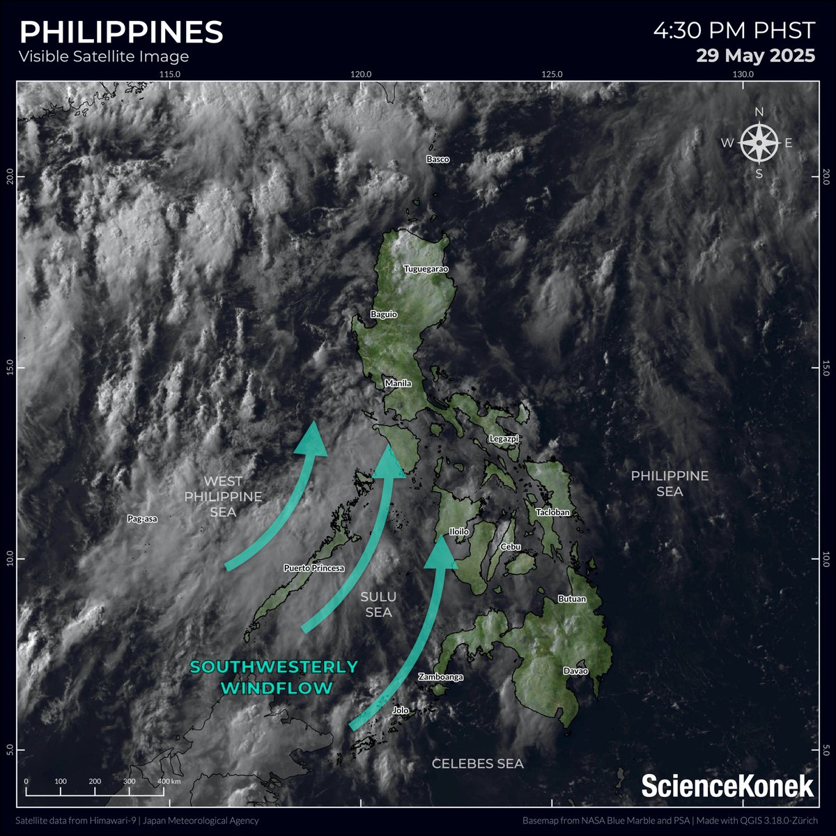
𝗦𝗢𝗨𝗧𝗛𝗪𝗘𝗦𝗧𝗘𝗥𝗟𝗬 𝗪𝗜𝗡𝗗𝗙𝗟𝗢𝗪 𝗧𝗢 𝗕𝗥𝗜𝗡𝗚 𝗥𝗔𝗜𝗡𝗦 𝗢𝗩𝗘𝗥 𝗠𝗜𝗠𝗔𝗥𝗢𝗣𝗔 𝗔𝗡𝗗 𝗧𝗛𝗘 𝗪𝗘𝗦𝗧𝗘𝗥𝗡 𝗦𝗘𝗖𝗧𝗜𝗢𝗡 𝗢𝗙 𝗩𝗜𝗦𝗔𝗬𝗔𝗦 𝗧𝗢𝗡𝗜𝗚𝗛𝗧 ☔
Maulang gabi ang inaasahan sa #MIMAROPA, #WesternVisayas, at #Negros Island Region ngayong gabi dahil sa southwesterly windflow. Mga localized thunderstorm naman ang nagpapaulan sa nalalabing bahagi ng bansa, ayon sa PAGASA.
➡ Bagamat bumaba ang mga paulan ng southwesterly windflow sa MIMAROPA at kanlurang bahagi ng Visayas ngayong gabi, inaasahan pa ring makakaapekto ito sa mas malaking bahagi ng Luzon, kasama ang Metro Manila, simula bukas (Biyernes).
➡ Halos maulap hanggang sa makulimlim na panahon na may mga pag-uulan at thunderstorm ang inaasahan sa malaking bahagi ng Luzon bukas, partikular sa kanlurang bahagi - Metro Manila, Ilocos Region, Central Luzon, at CALABARZON.
Manatiling updated sa lagay ng panahon. Ingat po!
𝗦𝗰𝗶𝗲𝗻𝗰𝗲𝗞𝗼𝗻𝗲𝗸
29 May 2025 | 5:00 PM

TINGNAN: Sitwasyon sa polling precinct sa Andres Soriano Memorial Elem. School sa Roxas, Palawan. | via Ann Ramos
#NET25NewsandInformation
#MataNgHalalan #Halalan2025
#Eleksyon2025 #MIMAROPA


#PepitoPH padayon bicol! God bless us all! #bicolregion #calabarzon #northern #central #luzon #mimaropa

#tacit #RnD #2 #researchanddevelopment #SanVincente #Mimaropa #visualresearch #training #practice #searching #Philipines #visualdevelopment #visdev #ideas #tacitpondering #tacitdesign #picturebooks #design #illustration #adobefresco #digitalpainting #picturebookillustration #picturebooksforall #illustraiton #tacitblocks #type #graphicdesign

𝗦𝗜𝗚𝗡𝗜𝗙𝗜𝗖𝗔𝗡𝗧 𝗥𝗔𝗜𝗡𝗙𝗔𝗟𝗟 𝗧𝗛𝗥𝗘𝗔𝗧 𝗧𝗢𝗗𝗔𝗬⚠️
For: 01 September 2024
Mas maraming lugar na ang makakaranas ng malalakas na pag-ulan dulot ng bagyong #EntengPH at lumalakas na #habagat, partikular sa #MIMAROPA, #BicolRegion, at #Visayas ngayong hapon at gabi. May mga pag-uulan ring sa nalalabing bahagi Southern Luzon at Mindanao.
🟠 𝗠𝗔𝗟𝗔𝗞𝗔𝗦 𝗛𝗔𝗡𝗚𝗚𝗔𝗡𝗚 𝗦𝗔 𝗠𝗔𝗧𝗜𝗡𝗗𝗜𝗡𝗚 𝗣𝗔𝗚-𝗨𝗟𝗔𝗡
➡ Camarines Sur
➡ Albay
➡ Sorsogon
➡ Masbate
➡ Northern Samar
➡ Samar
➡ Eastern Samar
➡ Biliran
➡ Occidental Mindoro
➡ Northern Palawan including Calamian, Cuyo, and Cagayancillo Islands
➡ Antique
➡ Negros Occidental
ℹ️ Mataas ang tiyansa ng mga kabi-kabilang mga pagbaha at pagguho ng lupa.
🟡 𝗞𝗔𝗧𝗔𝗠𝗧𝗔𝗠𝗔𝗡 𝗛𝗔𝗡𝗚𝗚𝗔𝗡𝗚 𝗦𝗔 𝗠𝗔𝗟𝗔𝗞𝗔𝗦 𝗡𝗔 𝗣𝗔𝗚-𝗨𝗟𝗔𝗡
➡ Quezon
➡ Marinduque
➡ Romblon
➡ the rest of Eastern Visayas
ℹ️ May tiyansa ng mga pagbaha at at pagguho ng lupa, lalo na sa mga lugar na madalas apektado ng mga ito.
☔ Ang nalalabing mga bahagi ng MIMAROPA at Mindanao ay makakaranas ng makulimlim na papawirin at ilang mga pag-uulan at thunderstorm. Magiging makulimlim na rin sa Metro Manila, Central Luzon at nalalabing bahagi ng CALABARZON.
⛈️ Ang nalalabing bahagi ng bansa ay may tiyansa lamang ng mga localized thunderstorm.
𝗦𝗰𝗶𝗲𝗻𝗰𝗲𝗞𝗼𝗻𝗲𝗸
As of 11:00 AM PhST
01 September 2024

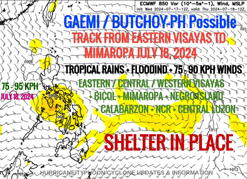
*#WestPacific: #TROPICS
- #PHILIPPINES #LUZON #VISAYAS #MINDANAO #Manila #Samar #EasternVisayas #Bicol #CentralVisayas #Mimaropa #NegrosIsland #WesternVisayas #NCR #CentralLuzon
- #Gaemi #ButchoyPH #Butchoy
- #91W #Invest91W
-BLOG/MAPS/SATELLITE:
https://t.co/xgMLH4kdg6
Most Popular Users

Elon Musk 
@elonmusk
241.8M followers

Barack Obama
@barackobama
119M followers

Cristiano Ronaldo
@cristiano
114.6M followers

Donald J. Trump
@realdonaldtrump
111.9M followers

Narendra Modi
@narendramodi
107.2M followers

Rihanna
@rihanna
98.7M followers

NASA
@nasa
92.4M followers

Justin Bieber
@justinbieber
91.8M followers

KATY PERRY
@katyperry
90.1M followers

Taylor Swift
@taylorswift13
84M followers

Lady Gaga
@ladygaga
75.5M followers

Virat Kohli
@imvkohli
73.5M followers

Kim Kardashian
@kimkardashian
70.9M followers

YouTube
@youtube
68.8M followers

Neymar Jr
@neymarjr
66.5M followers

Bill Gates
@billgates
65.3M followers

Selena Gomez
@selenagomez
63.1M followers

The Ellen Show
@theellenshow
62.3M followers

CNN
@cnn
61.8M followers

X
@x
60.7M followers