Our new Georeferencer eliminates the technical friction of manual file conversion for five major formats: PNG, JPEG, PDF, TIFF, and WebP. It allows you to define the location of your geodata effortlessly.
Find out more: https://t.co/gIl65LMk8H
#MapTiler#Geodata#WebMapping
QGIS NASA OPERA Plugin + AI Agent (Full Tutorial)
I have been collaborating with NASA Jet Propulsion Laboratory (JPL) to make the NASA OPERA data more accessible and integrate AI-powered functionalities with open-source geospatial frameworks. Check out the project website: https://t.co/LN6vbRq0JP
In this step by step tutorial, you will install the NASA OPERA QGIS plugin, connect your Earthdata account, and explore datasets like surface water, disturbance, and displacement. You will also learn how to use the AI assistant to query and analyze satellite data using natural language and voice commands.
Video tutorial: https://t.co/RxIN8TQXwx
QGIS Plugin Repo: https://t.co/91NMUnZR4O
#QGIS #OPERA #EarthObeservation #geospatial #AI
A sneak peek at the upcoming QGIS OpenGeoAgent plugin!
Run geospatial analysis and visualization using natural language, powered by over 480 geoprocessing tools from WhiteboxTools.
This brings a new level of accessibility to advanced spatial workflows directly inside QGIS, making it easier to explore, analyze, and visualize data without writing code.
Explore the projects:
• GeoAgent: https://t.co/WgiWV1wGMS
• whitebox-python: https://t.co/5ORYDDuEPI
• WhiteboxTools: https://t.co/6qE0OeDRca
Huge credit to Dr. John Lindsay @whiteboxgeo for developing WhiteboxTools!
#QGIS #geospatial #opensource
🏞️ New environment datasets, part of Google Earth AI, including Air Quality, Pollen, and Weather are now available in experimental ➡️ https://t.co/PmL1xAEUM4
We're empowering industries with advanced environmental intelligence to go beyond real-time data and unlock environmental insights through hyper-local, high-res historical data, seamlessly integrated with BigQuery. These datasets build upon our suite of Environment APIs to help organizations transform complex data into actionable insights for proactive planning, improved health outcomes, and robust business resilience.
🌦️ Weather insights dataset offers ~5 years of high-res data, capturing precise details down to 0.1 degrees globally and ~4kms in the U.S. and Europe on an hourly basis
🍃 Air Quality and Pollen insights datasets pinpoint the concentration of pollutants and pollen types down to a 500m or 1km grid, providing the accuracy needed to eliminate "blind spots"
Are you ready to explore how you can use these datasets to improve insights? Learn more and sign up for early access at the link above.
𝗙𝗼𝗿 𝘁𝗵𝗲 𝗳𝗶𝗿𝘀𝘁 𝘁𝗶𝗺𝗲 𝗶𝗻 𝗵𝗶𝘀𝘁𝗼𝗿𝘆, 𝗮𝗴𝗿𝗶𝗰𝘂𝗹𝘁𝘂𝗿𝗮𝗹 𝗳𝗶𝗲𝗹𝗱 𝗯𝗼𝘂𝗻𝗱𝗮𝗿𝗶𝗲𝘀 𝗵𝗮𝘃𝗲 𝗯𝗲𝗲𝗻 𝗺𝗮𝗽𝗽𝗲𝗱 𝗮𝘁 𝗴𝗹𝗼𝗯𝗮𝗹 𝘀𝗰𝗮𝗹𝗲.
I've been collaborating with the Fields of the World (FTW) organization for over a year through Taylor Geospatial and it's finally released publicly in cloud storage for anyone to use, at no cost.
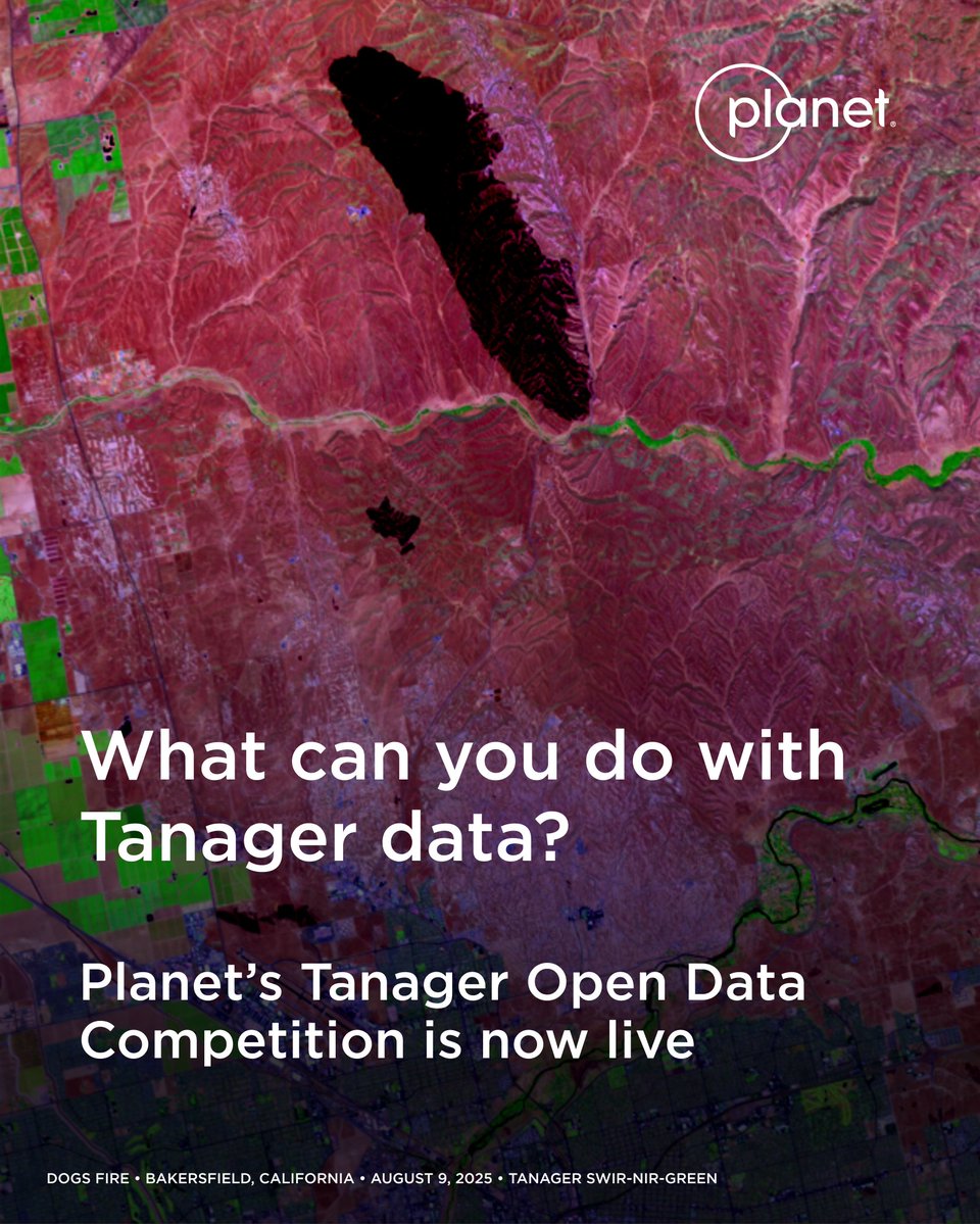
We’re calling on researchers, students, and analysts to put hyperspectral data to use. 📣 Our Tanager Open Data Competition is now live! Participants can use our Tanager open source imagery to showcase real-world examples that are helping make a difference for life on Earth.
Learn more about the competition and register here: https://t.co/LdcD3xwf8Q
¿Sabías que puedes descargar imágenes satelitales de alta calidad para tus investigaciones en minutos, sin conocimientos previos y de forma gratuita? 🌎🔍👨💻👀
Reunimos aquí las principales conclusiones y recomendaciones del seminario web de GIJN ➡➡ https://t.co/C93EPa7Nty