We are planning to grow > +50% till the end of the year and will be hiring for multiple geospatial roles for the data, processing and integration teams. https://t.co/HkzgPOfa1e
PhD position in Leipzig, combining #DeepLearning and #earthobservation. The topic looks great and Hannes is one of the best mentors I met during my time in academia!
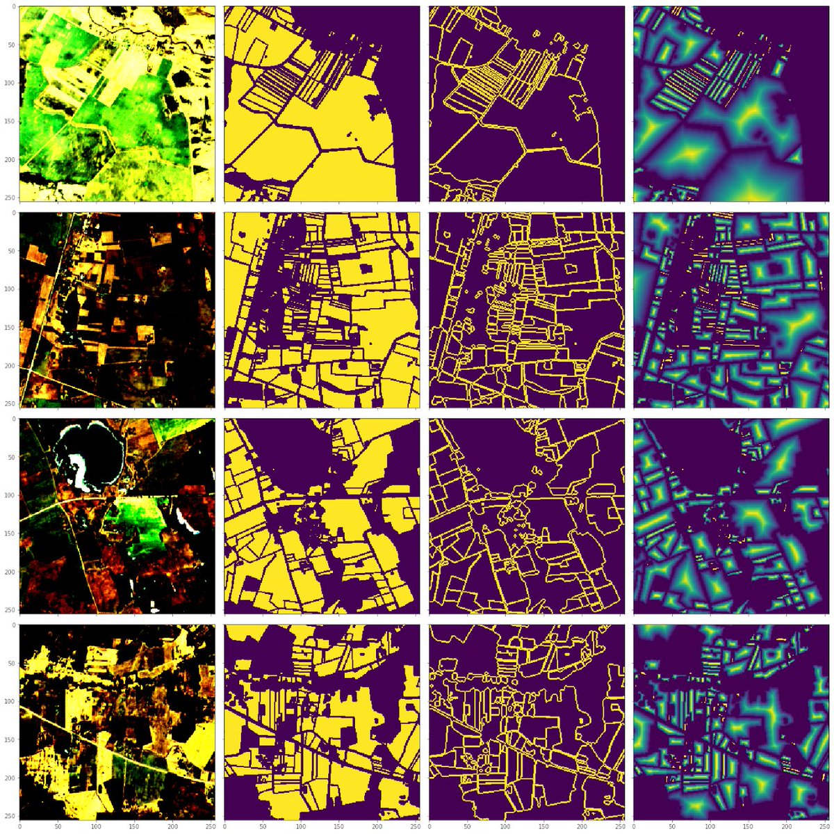
🟢A new update from our #eoresearch#datascience team - using Deep learning to automatically detect parcel boundaries.
Read more here:
https://t.co/Sks4itBOrH
Holy mother... @planetlabs will be releasing monthly basemaps for the entire central swath of the world for FREE because @Climateforest is funding them to publish this data for climate work. Mind-boggling barely begins to cover it. https://t.co/ok30ISsT0X
Mapillary acquired by Facebook and as a result making all their imagery available for commercial use. Could be interesting for self-driving car developers if this also extends to the Vista and Traffic Sign Datasets. https://t.co/3SQfMKCcIU
Die #CoronaWarnApp herunterladen – und gemeinsam das #Coronavirus bekämpfen:
Die App ist jetzt im App Store und im Google Play Store verfügbar. https://t.co/2MzLOViTdz
Check out 3 new public datasets in COG format!💥
We partnered w/ @NASA@awscloud to make Earth Observation data in more user-friendly formats (COGs!) via the AWS Public Datasets Program. @_aimeeb shares more on the blog.
(I can haz moar COGs plz?🦝)
https://t.co/EWVJZCQyfh
Sentinelsat v0.14 has been released with some long overdue bug fixes under the hood and improved handling of @CopernicusEU Long-Term Archive search and download. Thanks to all the contributors! 🧑💻https://t.co/JU2QOfw4o3
Thread) Today I share with you a giant effort to provide an unprecedented estimation of the global cover and geography of human settlements (HSs). We produced a 10 m resolution binary mask outlining HSs and built a model to explain settlement formation https://t.co/PMSuhwyX5H