The Polar Vortex just did something we’ve NEVER seen this early in the season.
For the first time on record, winds high above the Arctic reversed direction in early November, breaking the previous record from 1968 by 17 days.
The vortex has now begun spinning in its normal direction again, with forecasts suggesting it could rapidly strengthen toward the end of November.
This historic disruption could have major implications for winter weather, although the most significant impacts may develop across Europe and Asia rather than the United States.
This has NEVER happened in recorded history.
Seven major U.S. cities, including Denver, Minneapolis, and Fargo, have recorded ZERO measurable snowfall through November 13.
While each city has experienced unusually snowless starts before, all seven reaching this point together is unprecedented in the historical records.
Late fall is off to an incredibly unusual start across much of the United States.
America's skies are reopening after a 4 hour, 22 minute nationwide ground stop, the longest since 9/11 as far as we can find.
Our estimate: about 633,000 travelers were grounded. At the low point, just 336 planes were in the air over the lower 48, down from 4,266 when it started.
What happened: CBS News reports a failed update to the FAA's telecom network, run by contractor L3Harris, crashed the system that connects air traffic control facilities. Controllers lost radios at multiple centers. The FBI and Homeland Security say there's no sign it was an attack.
If you're flying tonight or Saturday, check your airline app before you leave. Southwest and JetBlue canceled the rest of tonight, and JetBlue is already canceling some Saturday flights.
The first clue was out at 3:44 PM: a National Weather Service notice saying Boston Center had "teleco issues," 80 minutes before officials called it a telecom outage.
This road went from bare to white in about 6 minutes today.
That's the Mt. Rose Highway above Lake Tahoe, and it's still coming down. Video: Nevada DOT
Every airport in the US is ground stopped. Nothing can take off.
This is everything still in the air over the country. The FAA's only reason so far: "extraordinary circumstances" and "reasons of safety."
What to do when a Tornado Warning happens. PLEASE DO NOT GO TO AN OVERPASS/UNDER PASS. It is NOT safe for when a tornado happens. You NEED to protect YOURSELF and not your Car.
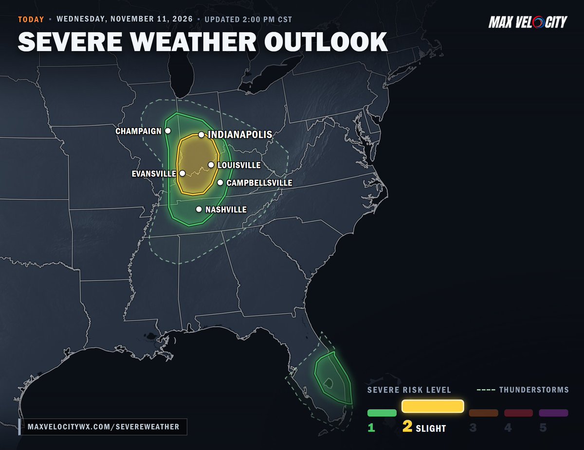
Large hail and damaging winds are possible across southern Indiana and western Kentucky the remainder of this afternoon and evening...
The severe risk was just upgraded for the area around Evansville, Louisville and southern Indiana. A cold front is pushing through, and just enough warm, humid air is streaming in ahead of it to fuel a line of storms, with a few that could spin.
Hail up to the size of ping pong balls and damaging wind gusts are the main threats, and a brief tornado can’t be ruled out. Storms should weaken this evening as they move east and lose that warm air.
A few strong storms are also possible across east-central Florida this afternoon.
The first freeze of the season is FINALLY on its way for Chicago, Detroit, Omaha, Kansas City and more by this weekend...
All 10 of these cities are running late on their first freeze. Chicago is forecast to drop to 29° Friday night, and only 15 of its 154 years on record have waited this long.
Omaha and Grand Rapids are even more overdue: only 4 years on record in Omaha and 3 in Grand Rapids have gone this late.
A brief tornado can’t be ruled out this afternoon and evening across Indiana, Kentucky and Middle Tennessee, including the Indianapolis, Louisville and Nashville areas...
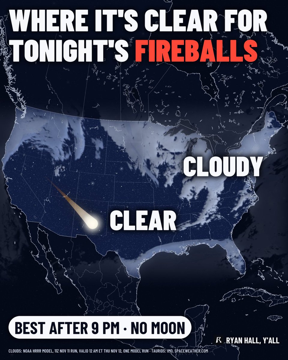
The Northern Taurids peak tomorrow night with no moon in the way...
It’s a slow shower, about 5 meteors an hour from a dark spot, but it’s known for the occasional bright fireball.
The West and Plains have the clearest skies, while clouds and rain cover the Great Lakes, Northeast and Pacific Northwest.
Your best window will be 11 PM to 4 AM local time.
Indiana, Kentucky, and Tennessee are holding the best tornado odds in the country tomorrow.
Indianapolis, Nashville, and Louisville all fall inside that zone, and SPC has it at Level 1 for tornado risk.
Omaha tied a record high of 75° today, and by Thursday night it’s forecast to drop to 29°...
That’s a 46-degree swing in just a few days. It would also be Omaha’s first freeze of the season, and if it happens Thursday night, it ties the LATEST first freeze on record there.
I'm using this Link to let y'all able to see my other social media. I have my Main TikTok, my Second TikTok, Main YouTube. Main TikTok isn't linked on the website but my Second TikTok is linked up.
https://t.co/uInb6QEYoM
The coldest air so far this season is about a week away. Freezing temperatures are likely over the northern half of Alabama by Nov 14-15…
Forecast temps attached to this post are valid for Huntsville…