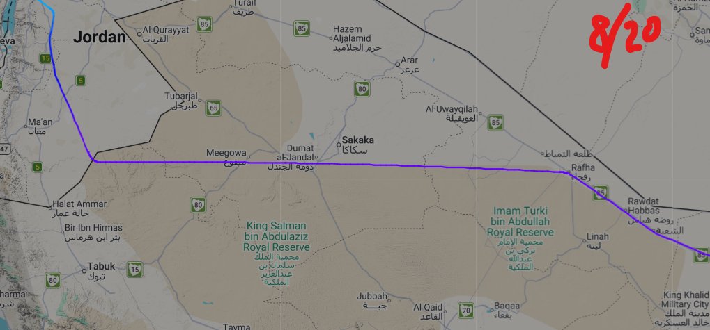
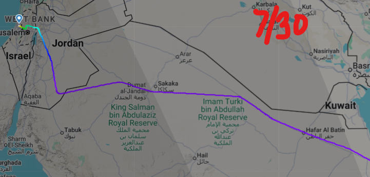
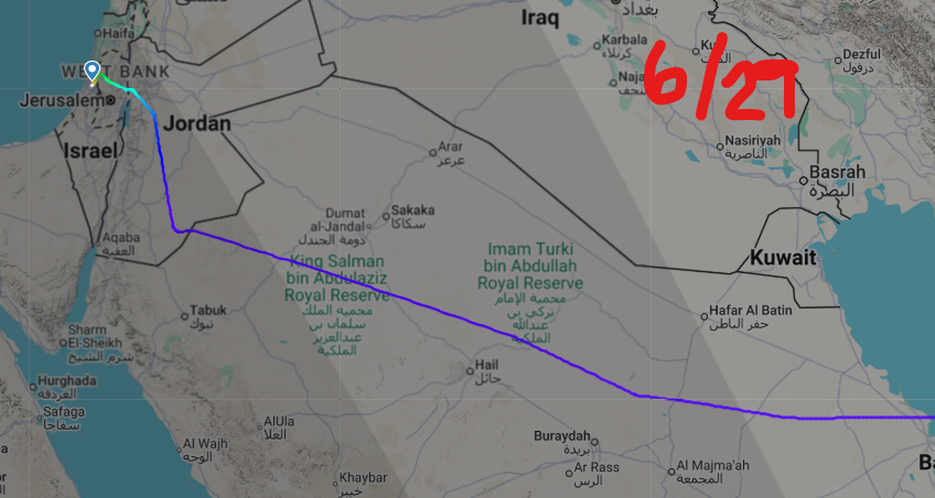
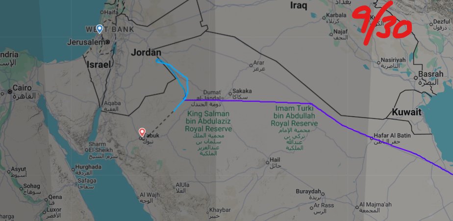
After a conversation and tip from my friend @Deb4Empowerment about the mountain ridge along FlyDubai FZ1073’s route to Tel Aviv, I went back through the historical flight tracks for this specific route and aircraft dating to November 3, 2025.
What I found caught my attention.
For months, the flights generally followed a more conventional path across Saudi Arabia toward Israel. But beginning around late June or July, the routing appears to start changing.
By August 9–10, the track looks increasingly aligned with the edge of the mountain ridge. By August 20, that alignment becomes even more pronounced.
That raises a very simple question: who was issuing or approving these flight plans after June, and why did the routing change?
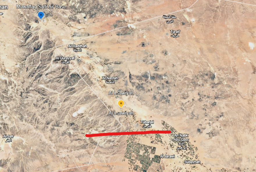
The mountain ridge matters because of what sits just beyond it.
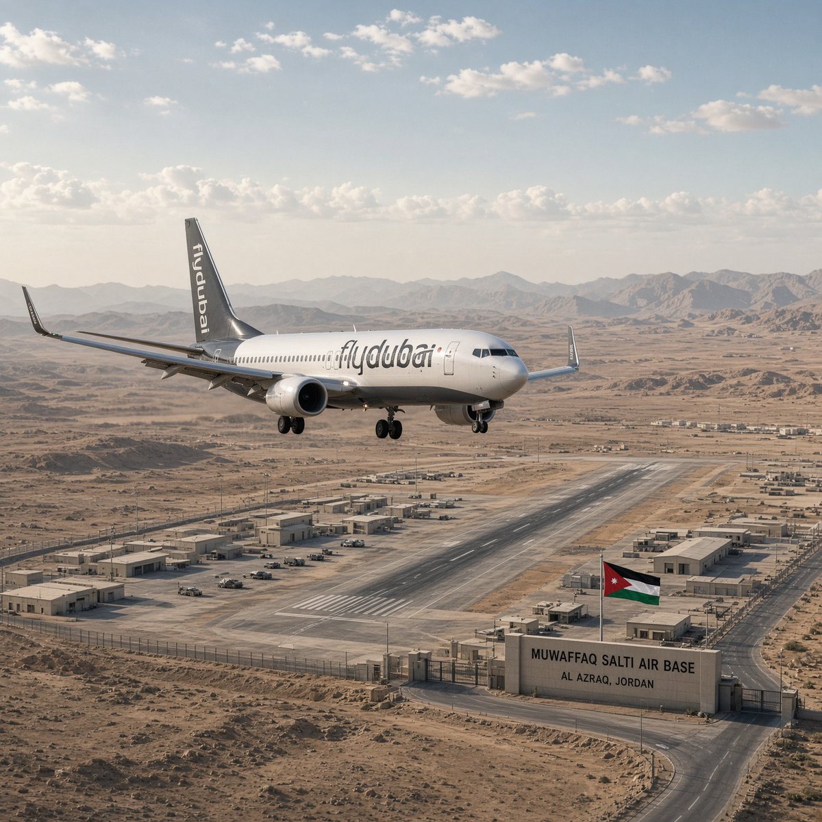
An aircraft continuing north on the far side of that terrain could be only minutes from Muwaffaq Salti Air Base in Jordan, while the ridge could potentially affect line-of-sight visibility depending on altitude and position.
I’m not claiming the historical routes prove intent. They don’t.
But when a flight pattern that was relatively consistent for months begins changing and increasingly follows a specific geographic feature, it is worth asking why.
I’m going to post the historical tracks side by side so people can look at the progression themselves. You decide.
In 1939, there were roughly 40 million Arabs worldwide, compared with about 450 million in 2026. There were approximately 17 million Jews worldwide in 1939, compared with about 16 million today. In 1939, there were four sovereign Arab states and no sovereign Jewish state; in 2026, there are 22 sovereign Arab states and one sovereign Jewish state. Roughly 90 percent of Poland’s Jewish population was murdered by Nazi Germany during the Holocaust. By comparison, approximately 3 percent of Gaza’s population has died during the current war, with most of those killed described as male combatants. The argument being made is that the destruction of European Jewry represents genocide, while the Gaza death toll from a war initiated by Hamas does not meet that comparison. So, Fuck All the Way Off!
And just a reminder, an internal United Nations investigation has concluded that UNRWA humanitarian workers in Gaza “very likely” participated in the October 7 Hamas massacre in which approximately 1,200 Israeli men, women and children were killed.
This day is profoundly painful for so many New Yorkers. It marks three years since the horrific war crimes of October 7. On that day, Hamas killed more than 1,100 Israelis and abducted 251 others. We grieve alongside our many friends and neighbors who still carry that unthinkable loss.
The suffering did not begin nor end that day. It instead continued through the Israeli government’s devastating, ongoing genocide in Gaza, in which it has killed more than 74,000 Palestinians—including more than 21,000 children. Even since the so-called ceasefire, more than 1,400 Palestinians have been killed. That suffering has intensified with every Israeli bomb dropped on ambulances waiting outside hospitals, every drone strike targeting a residential building or journalist, and every shipment of food aid turned away at a border crossing. Many New Yorkers are reckoning with this unbearable grief, and we mourn alongside them – all while knowing that our tax dollars fund these war crimes.
Three years later, we must refuse to accept a world in which occupation and apartheid continue, where war crimes are met with impunity, and our federal government continues its complicity with every arms shipment.
To honor the dead, we must fight for a world in which every person can live with freedom, safety, and dignity.
In 1939, there were roughly 40 million Arabs worldwide, compared with about 450 million in 2026. There were approximately 17 million Jews worldwide in 1939, compared with about 16 million today. In 1939, there were four sovereign Arab states and no sovereign Jewish state; in 2026, there are 22 sovereign Arab states and one sovereign Jewish state. Roughly 90 percent of Poland’s Jewish population was murdered by Nazi Germany during the Holocaust. By comparison, approximately 3 percent of Gaza’s population has died during the current war, with most of those killed described as male combatants. The argument being made is that the destruction of European Jewry represents genocide, while the Gaza death toll from a war initiated by Hamas does not meet that comparison. So, Fuck All the Way Off!
And just a reminder, an internal United Nations investigation has concluded that UNRWA humanitarian workers in Gaza “very likely” participated in the October 7 Hamas massacre in which approximately 1,200 Israeli men, women and children were killed.
USS Theodore Roosevelt (CVN-71) has deployed, followed almost immediately by the USS Makin Island Amphibious Ready Group — USS Makin Island (LHD-8), USS Anchorage (LPD-23) and USS John P. Murtha (LPD-26) — with the 13th MEU embarked.
These aren’t random ships slipping out of port. Roosevelt is expected to head into the CENTCOM theater, while the Makin Island ARG is also reportedly deploying toward the Middle East.
And there’s another piece worth watching: USS John S. McCain (DDG-56), an Arleigh Burke-class guided-missile destroyer, was reportedly seen at Diego Garcia last week.
Carrier. Amphibious assault ship. Two San Antonio-class transport docks. Marines. Destroyers.
The U.S. is moving serious combat power toward the Middle East — and the scale of the naval buildup is becoming increasingly difficult to ignore. These will be rotational but will likely stay overlapped a bit before swapping out. Can someone say Posture?
After doing more digging into flydubai flights and other airlines operating between Dubai and Tel Aviv, something stands out: the routing change appears to be specific to flydubai’s Dubai-to-Tel Aviv flights.
I reviewed both historical and current routes for other carriers, and I have not found the same altered flight path on their flights. I also checked flights operating from India to Tel Aviv and found no comparable routing change that placed the aircraft directly in line with the mountain ridge.
The Israeli carriers I reviewed were:
Arkia Israeli Airlines — IZ
Israir — 6H
EL AL Israel Airlines — LY
So far, none of those airlines show the same routing pattern I found on the flydubai flights.
U.S. naval positioning in the region is also changing. The USS George H.W. Bush, CVN-77, and its carrier strike group are no longer operating near Iran or the Persian Gulf and are now sailing through the eastern Indian Ocean toward the Malacca Strait with two Arleigh Burke-class destroyers. The strike group is scheduled to make a port call in Phuket, Thailand — pronounced poo-KET — from October 4 through October 10 for crew rest and recreation.
During that period, and until the USS Theodore Roosevelt arrives, the USS George Washington will be the only U.S. aircraft carrier operating in the CENTCOM area. The reported position of the George H.W. Bush is 6.29617 north, 94.51591 east. This would mark the first time since February 28 that only one American aircraft carrier has been operating in the CENTCOM area near Iran.
After a conversation and tip from my friend @Deb4Empowerment about the mountain ridge along FlyDubai FZ1073’s route to Tel Aviv, I went back through the historical flight tracks for this specific route and aircraft dating to November 3, 2025.
What I found caught my attention.
For months, the flights generally followed a more conventional path across Saudi Arabia toward Israel. But beginning around late June or July, the routing appears to start changing.
By August 9–10, the track looks increasingly aligned with the edge of the mountain ridge. By August 20, that alignment becomes even more pronounced.
That raises a very simple question: who was issuing or approving these flight plans after June, and why did the routing change?
The mountain ridge matters because of what sits just beyond it.
An aircraft continuing north on the far side of that terrain could be only minutes from Muwaffaq Salti Air Base in Jordan, while the ridge could potentially affect line-of-sight visibility depending on altitude and position.
I’m not claiming the historical routes prove intent. They don’t.
But when a flight pattern that was relatively consistent for months begins changing and increasingly follows a specific geographic feature, it is worth asking why.
I’m going to post the historical tracks side by side so people can look at the progression themselves. You decide.
🇷🇺 RUSSIA’S CENTER 2026: DRONES, MISSILES AND ROBOTS TAKE THE BATTLEFIELD
A look at Russia’s massive military exercises featuring hundreds of drones, robotic systems and live firepower.
Just look at this Axe which the Co-Pilot used to attack the Captain in the Fly Dubai incident. It’s a heavy-duty emergency axe with a sharp cutting edge, built to break through tough aircraft materials when normal access is blocked. It looks and is like a serious piece of equipment. In the wrong hands, a tool with this kind of weight and cutting edge could cause devastating injuries.
And for your information, this tool is a must to have inside an aircraft. Aviation regulations require aircraft with more than 19 passenger seats to carry emergency equipment such as a crash axe. An emergency tool designed to help save lives suddenly became part of an attack inside Fly Dubai cockpit!
The UAE Attorney-General confirmed that the co-pilot attacked Captain Smit Machchhar with the aircraft’s crash axe inside the cockpit before attempting to take control of the aircraft.
The axe is for an A320 corkpit, not the exact one which was used.
The flydubai captain’s account of what happened inside that cockpit now raises a major question about the aircraft’s sudden descent against his Israel was the target statement.
According to the captain, the co-pilot first asked if he could pray in the cockpit.
A few minutes later, the captain was repeatedly struck in the back of the head. His vision blurred. Then he felt the aircraft enter a sharp descent. (but the first descent was only about 1,000 feet before a turn to the right towards the mountain ridge)
He managed to open the cockpit door, only for the co-pilot to shut it again. People outside reportedly entered the cockpit access code, but the co-pilot allegedly refused to unlock the door from inside.
The captain was lying injured on the cockpit floor, believing he might die, he says he found “one last fight,” forced himself toward the door, reached the internal twist handle and opened it allowing others into the cockpit to help regain control.
And this is where the flight path matters.
If Israel was truly the intended target, why initiate such an aggressive descent at that point?
If Al-Salti Air Base in Jordan was instead the intended target, descending rapidly would make considerably more sense. The aircraft would need to lose altitude, and the nearby mountainous terrain raises the possibility that a lower flight path could have reduced its exposure to radar.
It does not prove Al-Salti was the target. But the timing of the descent, the terrain and the captain’s account make the question worth examining:
Was the aircraft crashing immediately or was the co-pilot trying to get it low enough to continue somewhere else just a few minutes away unseen?
@DD_Geopolitics@sarahadams Just gonna leave this right here.....cause maybe she shouldn't sit this one out eh? pages 5 and 17 if you need help. https://t.co/haEc5Lg10G
First, I want to thank my friend @Deb4Empowerment for bringing a very compelling theory to me during @based_biased’s TikTok Live last night regarding the potential target of the Flydubai Flight FZ1073 and the possibility that it was the U.S. airbase in Jordan.
I kept coming back to one question: Why did the aircraft travel that far along the Saudi border before making its turn? Looking at the flight path alongside the terrain, the theory begins to make much more sense.
Look closely at the images. The turn is circled and appears to occur along a line leading toward the beginning of the mountain ridge. The aircraft then turned to the right. From that point, its continued direction would have taken it toward the area of the U.S. base in Jordan, with the airbase only minutes away, as seen in the image I created the night before.
The yellow marker represents the approximate location where the aircraft made that turn, before the emergency code was transmitted.
I believe this possibility deserves serious scrutiny, particularly given the long-documented relationship between al-Qaeda figures and Iran, including the presence and facilitation of some al-Qaeda members inside Iran. I am examining whether there could also be an IRGC connection, but that remains part of the theory rather than something established by the flight path alone. We now know the co-pilot had undergone Islamist radicalization and intended to bring down the aircraft with more than 170 people aboard. But where?
The geography, timing of the turn, proximity to the base, and subsequent emergency situation are what make this theory worth examining.
@nick_matau Found possible prior test runs, or indications that someone involved in building the flight plans may have been helping shape the routing before the incident. https://t.co/OoK3Io7V3P
After a conversation and tip from my friend @Deb4Empowerment about the mountain ridge along FlyDubai FZ1073’s route to Tel Aviv, I went back through the historical flight tracks for this specific route and aircraft dating to November 3, 2025.
What I found caught my attention.
For months, the flights generally followed a more conventional path across Saudi Arabia toward Israel. But beginning around late June or July, the routing appears to start changing.
By August 9–10, the track looks increasingly aligned with the edge of the mountain ridge. By August 20, that alignment becomes even more pronounced.
That raises a very simple question: who was issuing or approving these flight plans after June, and why did the routing change?
The mountain ridge matters because of what sits just beyond it.
An aircraft continuing north on the far side of that terrain could be only minutes from Muwaffaq Salti Air Base in Jordan, while the ridge could potentially affect line-of-sight visibility depending on altitude and position.
I’m not claiming the historical routes prove intent. They don’t.
But when a flight pattern that was relatively consistent for months begins changing and increasingly follows a specific geographic feature, it is worth asking why.
I’m going to post the historical tracks side by side so people can look at the progression themselves. You decide.
Then why did the plane turn to the right before the door was opened? Why did the flight planning team move the flight path closer to the mountain edge just opposite of Jordan? I don't believe Israel was the target at all. The plane was diving already before the door was even opened. What sits opposite of those mountains to the NW just minutes from the incident location?
muwaffaq salti air base