Incredible supercell structure timelapse over Lake McConaughy in western Nebraska during our late May chase trip. Greatest storm structure I have ever seen! Check out the teeth-like VVS in the vault region! #NEwx#timelapse#4kUHD#supercell#photography
📝With multiple rounds of severe weather in the forecast, prepare now before it's too late!
✅ Secure loose outdoor objects
✅ Consider moving your car away from trees
✅ Keep your cell phone charged
✅ Have multiple ways to receive warnings
#IAwx
Storms return to IA tomorrow afternoon and may bring another round of heavy rain for some areas that have already received a lot of rain. Some flash flooding and creek rises are possible! If you encounter any flooded roadways, make sure to turn around, don’t drown! #IAwx
Strong to severe storms are possible over the next few days, with this potential mainly over northern Iowa Monday evening, and over much of Central Iowa Tuesday afternoon to evening. The main hazards with any storms would be damaging winds, large hail, and heavy rain. #iawx
With multiple rounds of severe weather ahead, don't let a dead battery or lost signal catch you off guard. Make sure you have multiple ways to receive warnings! #IAwx
Another round of strong to severe storms is expected across much of Central Iowa this Friday, with activity likely to ramp up during the afternoon and evening hours. All modes of severe weather are currently possible across Central and Southern Iowa.
I had a great time with friends at the Central Iowa NWA Doppler Radar and Severe Storms Conference in Ankeny, IA this year. Such an amazing conference and a near record turnout this year!
Presentations ranged about:
> Nudgers and mergers and how they affect simulated torgen
> Texas flooding
> Climate studying for future severe weather
> ICECHIP/hail trainings
> Historical tornadoes and new approaches to tornado histories
> The Enderlin EF-5
> Derechos
> Radar interrogation training
> Social science study on having a severe weather plan
> QLCS tornado warning examples
> Tornado/QLCS relationship, QLCS merger types, other multi-cell chaos, and warning strategies
> Broadcast and photography training
> And much more!!
I had a great time meeting other NWS Mets across the US/Midwest and hanging out with old and new friends as well. (Pictured here is @mark_debruin and @TreyTwister_WX)
See you all next year in early April!
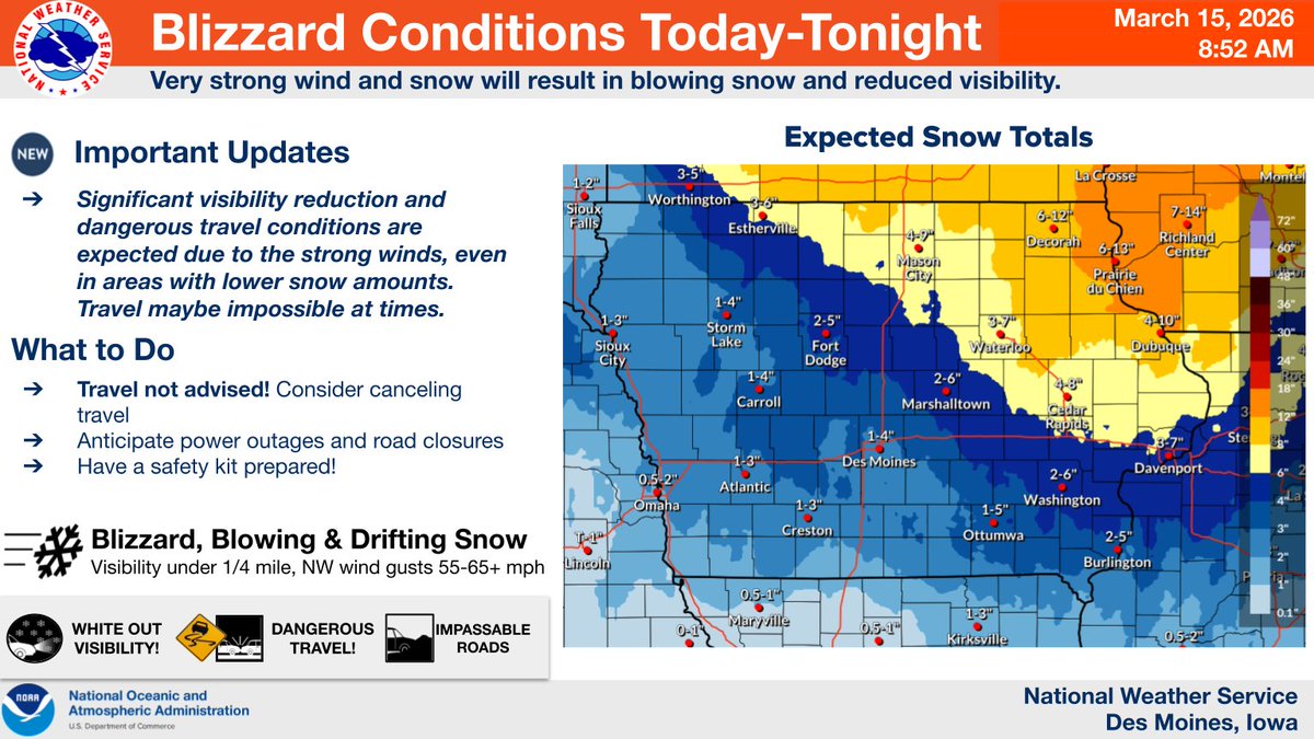
🚨Blizzard conditions with very dangerous travel conditions developing today and tonight.🚨
What makes this event unique?
Heavy snow is expected over parts of Iowa but these amounts are not rare for March. See the following slides for what makes this a rare/very rare event...1/3
Confidence has increased in the location of a heavy snow band later today, prompting a Winter Storm Warning for parts of Iowa. Within this band snow will fall and accumulate rapidly, leading to hazardous travel conditions. Please check for updates before hitting the roads! #IAWX
HERE IT IS! “Storms Across States: Storm Chasing 2025”. Didn’t get in all the chasing I wanted to do this year, but it was another fun year. FULL VIDEO: https://t.co/5FE8XyBvtv
#txwx#cowx#newx#ilwx#inwx#ohwx#pawx#stormchasing
Life update for the handful of people left on this platform, I will be starting as a meteorologist for NWS Des Moines in January! Excited to move back to Iowa and help protect Iowans from the severe weather I understand best!
Two consecutive nights of aurora watching in Lincoln, NE! Saw the G4 but didn't have my camera (classic). But I think last night's G3 was enough to scratch the photography itch for me.