World Travel/Media Sales/International Relations Master. Enjoying a front row seat on this wild ride into history! Military, Trade, Freedoms, Stewardship
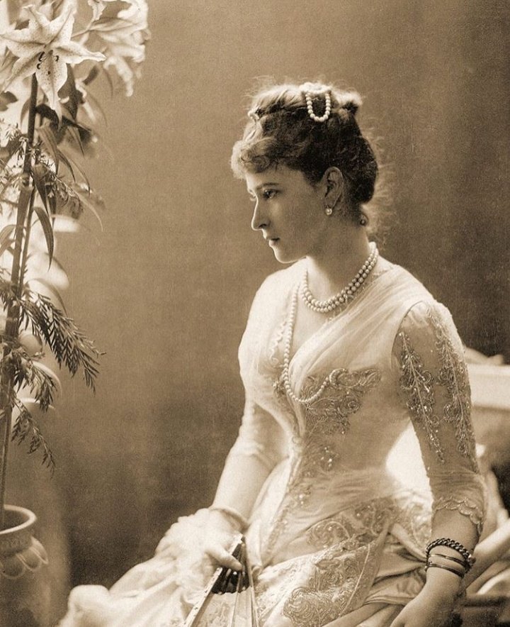
Princess Elisabeth of Hesse, later Grand Duchess Elizabeth Feodorovna of Russia, wife of Prince Sergei Alexandrovich and sister of Empress Alexandra Feodorovna. Photographed by Hayman Selig Mendelssohn in 1887.
"Map of the Kingdom of Poland and the Grand Duchy of Lithuania" (1705) by Pieter Pickaerdt (c. 1668–1737) and Adriaan Schoonebeek (1661–1705). An interesting map published in Russian, in Moscow in 1705, showing the territories of the Polish–Lithuanian Commonwealth, parts of Muscovy, and neighboring lands. It was engraved by the Dutch-born artist Pieter Pickaerdt, while the decorative cartouche was created by Adriaan Schoonebeek. What makes this map particularly interesting is that it was produced during the reign of Peter the Great, at a time when the Commonwealth was still one of the largest states in Europe, although already in a period of political decline. The map was printed in Moscow's Kremlin Armoury and reflects Russia's growing interest in the lands to its west.
"Map of the Grand Duchy of Lithuania and Its Neighboring Lands". Commissioned by Mikołaj Krzysztof Radziwiłł, created in 1625 by Willem Janszoon Blaeu, Joan Blaeu, and Hesselus Gerardus. From the collection of the National Museum in Kraków.
"Prvssia accvrate descripta - Prussia Accurately Described” (1635)". A detailed copper engraving map of the Duchy of Prussia published in Amsterdam in 1635 by Willem and Joan Blaeu, based on the earlier work of Kaspar Hennenberger. Measuring around 38 × 50 cm. The title appears in an elaborate ornamental cartouche surrounded by 4 allegorical figures and crowned with the Prussian coat of arms beneath a princely crown. The map includes the cardinal directions in Latin - Septentrio, Meridies, Occidens, Oriens. The geographic content and legend on the map itself are largely in Latin. At this point the word "Prussia" still did not yet carry that later harsh militaristic sound it would gain in European history, but things would begin changing not even a century later.
"Brandebvrgvm Marchionatvs cum Ducatibus Pomeraniae et Mekelenbvrgi - The Margraviate of Brandenburg with the Duchies of Pomerania and Mecklenburg" (1635). Poland’s lovely sneaky neighbour. A richly detailed copper engraving map published in Amsterdam in 1635 by Willem and Joan Blaeu. Measuring around 39.5 × 52 cm, the map presents Brandenburg together with Pomerania and Mecklenburg in the elegant decorative style. The title is placed on an ornamental pedestal decorated with the coat of arms of Brandenburg and an allegorical figure.
"Tartaria sive Magni Chami imperivm - Tartary, or the Empire of the Great Khan” (1635). A large copper engraving map published in Amsterdam in 1635 by Willem and Joan Blaeu, showing the enormous and still only partly understood lands of Tartary stretching across northern Asia and Siberia. At the time, for many Europeans this vast region was still a distant, semi-mythical world associated with the Mongols, steppe peoples, caravans, and the legacy of the Great Khan. The map measures around 38 × 49 cm, the title appears inside an ornamental cartouche in the lower right corner.
@boudewijnsteur Wat een onzin............Hij werd tot levenslang veroordeeld wegens het niet willen afzweren van de GEWAPENDE strijd (al dan niet terecht)....en daarmee het willen omverwerpen en saboteren van de Staat. Hij had veel eerder vrij kunnen komen, dat is hem ook aangeboden!!
@WillemdePrater Nou ja. Ik krijg net een reclamemail van de Belgische economische Krant De Tijd. 😂😂
Veel kijk- en leesplezier,
Peter De Groote
Hoofdredacteur De Tijd
@historyinmemes What do you mean "a playful spelling".....
He was a Dutch speaker.... as a large remnant of the founders of New Netherlands stil managed at that time......(even Theodore Roosevelt had heard it speak in Church)
@procrastixote Yes but the Southern One is the oldest and became the main center of veneration of the archangel in the entire West, a typological model for all the others as it inspired and fueled its Renaissance after the Roman decline...(largely overshadowed by its impressive brothers)
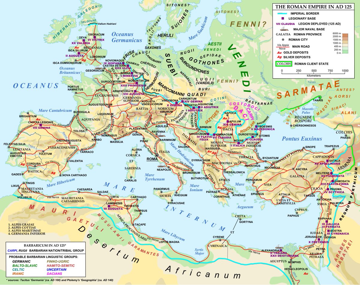
Roman Empire 125AD. Physical map with main roads, major cities, legion names, location of legionary and naval bases, gold and silver deposits, location and linguistic group of barbarian tribes. https://t.co/p75VAtfUSV #MapPorn
The so-called #Sword of #Tiberius perfectly embodies #Roman visual language and #political propaganda, tied up with Rome’s foreign wars and the Imperial succession. The sword was discovered in 1848 near the river #Rhine, outside the German city of Mainz.
#History#Archaeology