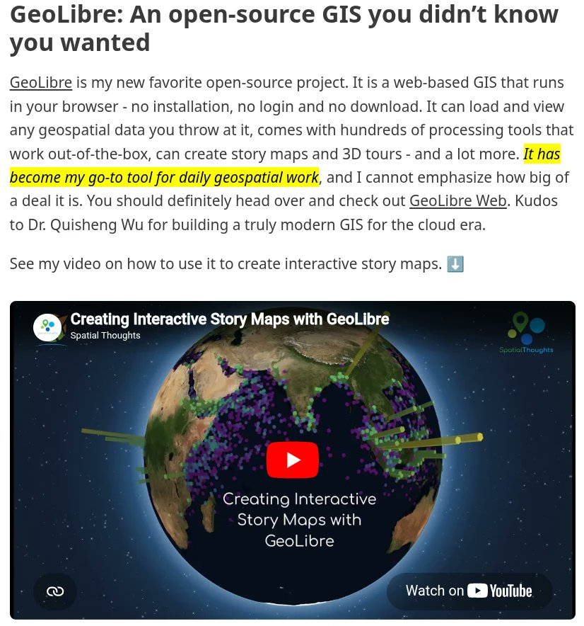
A big thank you to @spatialthoughts for for featuring GeoLibre in the latest Spatial Thoughts newsletter (https://t.co/oY7QeLgiL7)!
I also sincerely appreciate his thoughtful feedback, bug reports, and feature requests on GitHub. Contributions like these help make GeoLibre a better open source GIS for everyone.
If you would like to give GeoLibre a try, check out the links below:
- Launch GeoLibre Web: https://t.co/8gMtkVtfnm
- GitHub: https://t.co/VXq8c1o2Nd
- Documentation: https://t.co/7VA2AQoCUc
#GIS #Geospatial #OpenSource #RemoteSensing #DataVisualization #MapLibre #GeoLibre
Google Earth Pro will be ending support and will be unavailalbe for new downloads after June 25, 2027!
If you are looking for an alternative, try out GeoLibre. It is a free and open-source, lightweight, cloud-native GIS platform for visualizing, exploring, and analyzing geospatial data. It runs everywhere you do, in the web browser, on the desktop, on mobile, and inside Jupyter notebooks, all while keeping your data local and private.
GeoLibre works across platforms:
- Windows: Microsoft Store / winget
- macOS: Homebrew
- Linux: AUR, COPR, Flatpak (FlatPark), .deb / .rpm / AppImage
Try it out:
- Launch GeoLibre Web: https://t.co/8gMtkVtfnm
- GitHub: https://t.co/VXq8c1o2Nd
- Documentation: https://t.co/7VA2AQoCUc
- Video tutorial: https://t.co/nmlHL8HAbq
#GIS #Geospatial #OpenSource #RemoteSensing #DataVisualization #MapLibre #GeoLibre
Someone tell Atandi that we have kept this video safely is a safe box that will be opened in 399 days.
We will book that appointment that you want us to book in 399 days.
We will not bother you sir, in fact we really regret making you a leader.
The only truthful man in Kenya. Hate him or love him, this man, Rigathi Gachagua, doesn't forget.
We now know why Ruto is killing Kikuyu businesses while empowering Somalis.
What a day that was!
The journey to #Ukombozi has started.
Join the movement today. Dial *456*9*9#, enter "Maraga27" to opt in for SMS updates on our campaign.
Afande 1: Ati "Ruto Go"......
Afande 2: Wewe ingia kwa jeneza Yako....ni yako?
Protestor: Si yangu.
Afande 1: ni ya nani? unabeba kama nani?
Protestor: Nimepewa nilete🙆🙆
Afande 2: Leo utalala ndani🤣🤣
Protestor: 🤣🤣🤣
Aiiii Kenyans are tired buana🤣🤣
GeoLibre v1.7.0 is here!
GeoLibre is a free and open-source, lightweight, cloud-native GIS platform for visualizing, exploring, and analyzing geospatial data. It runs everywhere you do, in the web browser, on the desktop, on mobile, and inside Jupyter notebooks, all while keeping your data local and private.
This release opens up the UI to plugins, adds inline color ramp previews across the styling panels, and makes the Whitebox toolbox browsable right from the Processing menu.
What's new in v1.7.0
- Plugin UI host API: Plugins can now register first-class right-sidebar panels, toolbar menus, and floating panels that dock beside the built-in Style panel instead of faking an overlay.
- Color ramp previews: Both the vector and raster style panels show each colormap's gradient inline, so you can see the colors while you pick rather than reading a list of names.
- Richer vector labeling: ArcGIS-style label controls for anchor, offset, rotation, wrap width, and letter case, plus modes that collapse stacked points at the same coordinate into a single label.
- Whitebox by category: Browse the whole Whitebox toolbox by category directly in the Processing menu, with an offline-bundled tool catalog for restricted environments.
- Collaboration at a glance: An on-canvas session badge and roster show a live dot, the connected-participant count, and who is in the session, with a clear way back to the map.
Try it out
- Live demo: https://t.co/hOVekblXMc
- GitHub: https://t.co/VXq8c1o2Nd
- Documentation: https://t.co/7VA2AQoCUc
- Release notes: https://t.co/Ki2oOpMzgb
#GIS #GeospatialData #OpenSource #RemoteSensing #DataVisualization #MapLibre #Python #Plugins
GeoLibre is now on the Microsoft Store!
Windows users can now install GeoLibre with a single click: signed, sandboxed, and auto-updating, straight from the Microsoft Store. No SmartScreen warnings, no manual installer downloads, no hunting for updates.
https://t.co/c2dsROEJ9g
GeoLibre is a free and open-source, cloud-native GIS platform for visualizing, exploring, and analyzing geospatial data, and it runs everywhere you do: in the browser, on the desktop, on mobile, and inside Jupyter notebooks. Your data stays local and private.
The Microsoft Store joins a growing list of one-command install paths:
- Windows: Microsoft Store / winget
- macOS: Homebrew
- Linux: AUR, COPR, Flatpak (FlatPark), .deb / .rpm / AppImage
Try it today and let us know what you build. Star the repo: https://t.co/VXq8c1o2Nd
#GIS #OpenSource #Geospatial #MapLibre #GeoLibre #DataScience #Mapping #MicrosoftStore