I just finished my winter outlook.
There is one part of the country that I think could get absolutely ROBBED this winter.
And another that could massively overperform for snow.
You’ll see the whole map very soon.
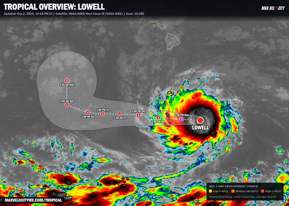
HURRICANE LOWELL forecast to become a Category 5 later today!
Lowell has continued to rapidly intensify and now has winds of 155 mph, making it a high-end Category 4 hurricane. The big thing to note with this forecast cone is that Lowell will likely remain a powerhouse through at least early next week.
A sharp turn northward is expected this weekend, but the ensembles become very murky beyond that point. Some solutions have Lowell impacting the uninhabited islands of Hawaii, while others bring it toward the main islands. There is far too much uncertainty to make an educated guess as to which scenario is most likely, so interests in Hawaii will want to keep a close eye on this hurricane.
The Atlantic just went all summer without a hurricane.
The first one could form TODAY, 40 miles off Louisiana.
Tropical Storm Edouard only has 40 mph winds, but it’s over 88° water, almost no wind shear, and radar shows a tiny eyewall trying to form.
Landfall is this afternoon.
It’s basically racing the coastline to become a hurricane.
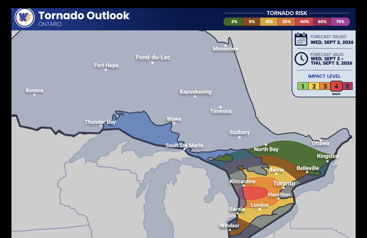
🌩️ National & Ontario Storm Outlook — This Afternoon & Evening 👇🇨🇦
Conditions are once again becoming favourable for the development of strong to severe thunderstorms this afternoon and evening across parts of Southern Ontario.
All the ingredients are coming together for what could be a significant severe weather setup across portions of the province later today. ⛈️
Storms, mainly non-severe, will continue across parts of the GTA and Eastern Ontario throughout the morning and early afternoon. However, a few much stronger rounds of thunderstorms are expected to move into the region later this afternoon and continue throughout the evening hours.
At this point, the strongest potential appears to be focused across areas east of Lake Huron and toward the #GTHA.
Severe thunderstorms are also likely along parts of the 401 corridor, stretching from London toward the eastern side of the GTA.
A lower, but still moderate risk, remains across Southwestern Ontario, as well as areas north of Barrie and east of #Toronto.
These thunderstorms could be capable of producing:
🌧️ Heavy rainfall
💨 Damaging wind gusts of 90–130 km/h
🧊 Large hail (quarter- to ping-pong-ball-sized)
🌪️ Tornadoes — perhaps several
⚠️ Today is definitely a day to keep an eye on the sky and closely follow ALL weather alerts issued by @environmentca.
We’ll do our best to keep you informed throughout the day as these storms develop, strengthen, and track across the region. 📡⛈️
🌩️ Prairies -------------------------------
Across parts of the Prairies, severe thunderstorms are also possible today. Heavy rainfall, strong winds, and large hail are all possible with the strongest storms.
🌪️ Tornado Risk
At this time, we are forecasting a HIGH chance of tornado development — 20–55% across parts of Southern Ontario, particularly for areas east of Lake Huron and across the northwestern GTA.
A 10–35% chance exists across #London, #Niagara, #Toronto, #GTA, #Barrie, #OwenSound, and surrounding areas.
A lower tornado risk is expected across deep Southwestern Ontario, but an isolated tornado still remains possible.
A much lower tornado threat remains across Eastern Ontario as well.
🚨 This is a situation we will be watching very closely throughout the day.
Stay weather-aware, have multiple ways to receive warnings, and take action immediately if a warning is issued for your area.
#OntarioWeather #ONStorm #SevereWeather #Thunderstorms #StormOutlook #Tornado #TornadoRisk #SouthernOntario #GTA #Toronto #LondonON #Niagara #Barrie #OwenSound #EasternOntario #Prairies #CanadaWeather
Whoa! Flagship weather model update shows Hurricane Lowell doing a "slingshot" maneuver and crossing near Kauai, Hawaii in 8-days.
Need to really watch this one closely this week.
Karina and Marie + another one --> Norbert (great name!)
Eastern Pacific has gone bonkers!
The Pacific has turned into a storm factory.
THREE storms are spinning out there right now, lined up like they’re on a conveyor belt.
Karina is a Category 4.
And Marie just formed at the end of the line, becoming the 13th named storm of the year.
We normally don’t get to #13 until October.
I guess this is what a “super El Niño” looks like.
Two 145 mph hurricanes are spinning in the Pacific at the same time.
That has only happened twice before.
The last time? September 1997. Right before the El Niño winter everybody still talks about.
Karina and Lowell are both monsters. Marie is lined up behind them and could become hurricane #3.
None are expected to hit land, but Hawaii will feel the surf.
This Pacific is trying to tell us something about winter.
Canadian supercell! A nasty supercell is about to cross Highway 402 in Ontario near Dorchester and Nilestown, with large hail between golf ball and tennis ball size. Cracked or shattered windshields likely!
Avoid roadways and shelter if in Mossley, Crampton, Putnam, Ingersoll, Salford, Mount Elgin, Culloden, Avon, Brownsville or surrounding areas.
This rotating supercell thunderstorm may eventually pose a tornado threat!
Tropical Storm Warnings just went up for Texas and Louisiana.
And landfall is tomorrow.
That’s basically ONE day of warning.
This thing is still just off Louisiana, and it could become Tropical Storm Edouard tonight.
Probably not a monster.
But parts of Texas could get up to 9 inches of rain.
El Niño is predicted to become the strongest ever observed in September, beginning a six-month run at record strength with a peak of +4.15°C.
That's according to the new CanSIPS model update, which also suggests that La Niña is possible during the second half of 2027.
For those who have been waiting for an update, Niño 3.4 sea-surface temperatures have been treading water at daily record "super El Niño" levels (≈2.6°C above the 1991-2020 baseline) for most of August.
The El Niño peak in the latest CFSv2 model run is now about 4.1°C.
Summer is not stopping anytime soon. We will see well above average temperatures as we move into September with highs in the Great Lakes Region ranging from the upper 70s to mid 90s!
This pattern may also bring a return of storm chances and subsequent severe weather concerns, but that isn't a guarantee by any means.
How do you feel about this? Are you team summer or team fall?
The Pacific has never been this hot in August.
Not in 1997, heading into the El Niño winter everybody still talks about. Not in 2015, before the only other one that comes close. Right now it's hotter than both.
If you're over 30 you remember at least one of these. The January '98 ice storm. The Florida tornado outbreak that killed 42. A year of rain in a month in California. 30 inches of snow from Jonas. 72 degrees in New York on Christmas Eve. And the flip side: DC got a tenth of an inch of snow all winter in 1997-98.
The good news about a Pacific like this is we see it coming months out, not hours. We'll be tracking it every week between now and winter.