Nazca Lines Decoded by ECDO Theory
The Nazca Central Plain Antipodal Axis MATCHES the orientation of the three Primary Mandalas at Nazca. They all orient to the same azimuthal bearing:
ECDO's Np' = 108°
Nazca Lines Decoded by ECDO Theory
The Nazca Central Plain Antipodal Axis MATCHES the orientation of the three Primary Mandalas at Nazca. They all orient to the same azimuthal bearing:
ECDO's Np' = 108°
Emi Koussi is a shield volcano in Northern Chad. It is the highest point in the Sahara, towering over 11,000 ft. It formed 1.4 to 2.3 million years ago as an outgrowth of the Tibesti hotspot.
Let's look at its antipode:
Emi Koussi: 19.8 N, 15.5 E
Antipode: 19.8 S, 164.5 E
Where does that bring us? To the Cook islands, to Rarotonga and the eponymous Rarotonga hotspot.
Rarotonga was formed between 1.1 to 2.3 million years ago. The same time period as Emi Koussi. For an almost perfectly antipodal volcanic hotspot.
Curious that.
Images credit:
Emi Koussi: Stefan Thungen
Rarotonga: Georgia Mann
I have decided to change my Twitter/X handle, for four reasons:
1) It is confusing switching between EcdoPrep and Methuselah- leading to mixups like the example below.
2) In the recent "cataclysm constructive criticism" exercise, it is probably a more opinionated handle than I should like.
3) It is awfully awkward to say. Poor @SunWeatherMan had to spend a full tithe of his syllables on the recent livestream enunciating "E-C-D-O-Prep"
4) While @EthicalSkeptic and I don't disagree on much, when we do disagree, it probably is not fair to him to have an account with 'ECDO' in the name arguing with him.
Perhaps, one day in the future, the idea of the earth flipping over will be one I can discuss publicly without undue tension with my day job. Perhaps one day I will not need an alias. But for now, I'm just @MethuselasMuse
The amount of daylight between this El Nino and anything else within recent record is growing. It will be one for the books for sure. Time has eluded me to do as much of the Argo float data analysis as I should like, but I hope to take a meaningful stab at it a bit later this year.
@SAVEtheTOMBOY I noticed the coordinates were off a bit, but reasoned the general conclusion would still follow.
And kudos for raising your hand when you found a mistake in your work. I have had to do that twice just this week.
You asked this same question a couple months ago. My answer has not changed. I have a day job and young children. I started this account out of guilt because I was doing a modicum of preparation, and imagined having to give account to God for saving myself and not trying to help anybody else.
What a great article out of left field. Or perhaps a coal field I should say. Nice work @SAVEtheTOMBOY
"In the previous pole configuration, all major US coal fields were located in tropical to subtropical latitudes (10°N to 39°N). This is precisely the climate zone where the Carboniferous lycopod forests (giant club mosses, ferns, horsetails) thrived—the vegetation that makes up the bulk of Appalachian and Illinois Basin coal."
...
"The ECDO model predicts that coal below the 2250 ft line should be bark‑rich, uniform, and laterally continuous, while coal above that line should be more variable, lower rank, and less uniform. This matches the observed difference between Appalachian bituminous (uniform, bark‑rich) and Powder River subbituminous (more variable, lower rank)."
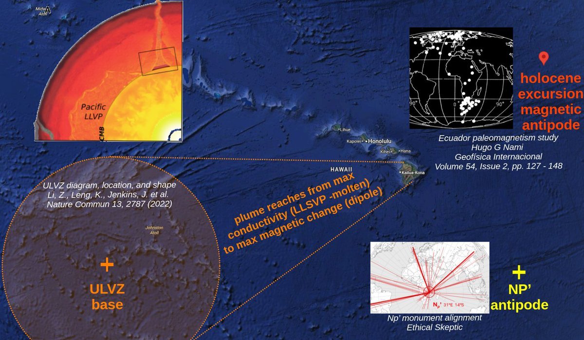
@DemiClawOne you are correct the figure is representative and not necessarily to scale. But the below map is to scale- the location and radius of the base. The reach toward the northeast is real.
I haven't done numerical heat transfer modeling since I was in college. It think it might be time to dust some of that off a bit.
The ULVZs (Ultra Low Velocity Zones) that sit beneath Hawaii etc. are curious. Here are two things that don't make much sense from this paper https://t.co/bTSmlg0iGU :
Curiosity one - the authors are skeptical that the Hawaii ULVZ can be as molten as the seismic data says it is. To quote: "the extreme shear velocity reductions of up to 40% that we observe would require a melt fraction likely to be above the percolation threshold. Additionally, these melts would likely be iron-rich and denser than the solid, causing them to drain out".
In a semi-molten material, the percolation threshold is the melt fraction above which the molten domains start to connect into broader networks, allowing net fluid flow - think of water draining out of a pumice stone. That threshold is about 1-3% melt fraction.
The paper's authors do not understand how the melt fraction could be as high as the math says it is- the molten material should be bit dense and would have drained down and away long ago. Instead, they turn to compositional differences to explain the findings.
But what if they melt fraction really is that high- because the ULVZ gets a little pulse of heat every time the mantle reorients? Under induction heating, this makes a lot more sense.
But here is curiosity number two- even under the Faraday heating approach, I find the shape a little bit perplexing here. It is too tall and columnar, isn't it? Shouldn't heat diffuse more broadly? I have a more radical idea percolating (pun intended) in back of my mind here, but it needs a bit more interrogation.
I agree any heat anomaly would dissipate over 400 million years- I am uncertain where that timeframe came from.
To clarify a bit:
- I accept the standard ~80 million year timemline for the Hawaii-Emperor seamount chain.
- Hawaii is pretty close to the ECDO S Pole
- I think it gets hit with induction heating every ~6000 years, with presumably ~13,000 such events over those 80 million years.
- I further observe that the plume above the ULVZ stretches from its base (SW) toward the NE where Hawaii is. The standard explanation is that this is slow mantle flow, but I can't help notice it is reaching strait for the magnetic S pole based on a study from Nami:
'imagine doing that to the ocean and expecting one spot to stay hot' - I think you are saying the heat would conduct outward and not stay in one 'spot'?
Also can you explain the 'holes in the bottom of the crust' analogy a bit?
I am looking at how to do some of the heat transfer calculations for these things. It is a touch complex but I will post the results as I can.
@Winston_104 Wait I missed the second pic. I see what you mean now.
I do suspect the hook is something slipping or giving near the CMB. But if that is shedding vs some magnetic reconnection vs something else, I am uncertain.
Good news: the video is up discussing the recent oddities in polar motion.
Better news: we're not tipping over tomorrow.
Best news: I think I pronounced Geoforschungszentrum more or less correctly.
https://t.co/F7WSImILZk
AAM + OAM (atmosphere + ocean) can account for 1-2 mas/day. So yes, there is more to the story than just that. And the wobble getting smaller still haunts me. But I think it is a bit of a reach to say that CMB shedding is causal. To be fair I don't know what it is- but I am skeptical we can assign causality with much confidence yet.
By "not tipping tomorrow" I was specifically referencing that the little accelerations over the past few weeks are entirely explainable via atmospheric + ocean forcing.
I disagree that the hooks are as dangerous as some people think. They look strange. I don't understand them. But the magnitudes of movement are so small. It would take many of them and larger to really move the needle.