@ahfultz Sorry, but your table only goes back 15 days. Where can I find the full table you are using, or did you make your own table from something else? I was looking at the link in you're profile, but could not understand where to find the relevant data.
Le Hon (1868) describes the closing chapter of the diluvian period, marked by a major submergence of Northern Europe following the deposition of the red diluvium and the overlying loess. He explains that this loess, called limon hesbayen by Dumont, blankets much of Belgium and feeds local brickyards, and that the red diluvium shows signs of violent, agitated water action that shaped the valleys making its origin one of the most debated questions in geology. Le Hon places this event around 11,000 years ago, corresponding to the “Reindeer Age", and notes "The deposit of the red diluvium must have been formed towards the end of this age. It would remain to explain the little duration that it would have had, according to some observers, the tumultuous inundation."
He cautions against overcorrection in scientific interpretation, observing "The reactions are often very strong in science as in politics and after having established the action of slow causes, one suppresses too much perhaps today in a violent manner the effects in the history of the Earth." While acknowledging that ordinary soil movements occur and complicate the picture, he argues they cannot alone account for the cold conditions of the time, when boreal fauna inhabited the region, concluding "A climatic phenomenon must therefore have occurred towards this epoch, which sufficiently indicates an evident change in the regime of waters and the distribution of the fauna."
After describing the caves of Massat, Bise, Savigné, etc., observes: At the termination of this period occurred the submergence of Northern Europe, spoken of by M. Dupont, when the waters in Belgium, at the epoch of the red diluvium, rose two hundred and fifty metres.
He frames this final great flood as the event that ended the Quaternary epoch, writing "The last great inundation, the memory of which has been transmitted from age to age by our race, marks the end of the Quaternary epoch. We have thus crossed the most obscure phase of humanity, the one in which man is least known by his remains and his works buried in the bosom of the earth; but here is the distant tradition which at last casts its faint light upon our history."
L'homme fossile en Europe: son industrie, ses moeurs, ses oeuvres d'art
H. LE HON (1868)
https://t.co/zYAGe95xa2
@HashZappa@EcdoPrep If I may, can I suggest a slight improvement? At least for the utility of the simulation. (1) It would be great to separate the S1 to S2 sims from S2 to S1. (2) It would be very useful to highlight the maximum reached altitude for the waterline, for each event.
4 paths to AI Super Intelligence (ASI)
https://t.co/quYBipANyN
https://t.co/25PSkyk6TS
Authors say within the "next decade"...
But I'd rather say they lack imagination.
LLSVP Axis Test 02:
Important clarification as I keep refining the analysis: the principal inertia axes and Euler axes are not the same thing.
The Euler axis is the axis that would generate a rotation from the present rotational pole to the recovered preferred inertia axis.
Across 5 mantle tomography models, the principal inertia axes cluster near 104 to 111°E.
The corresponding kinematic Euler axes cluster near 14 to 21°E.
This brings the comparison much closer to the proposed 31°E corridor from ECDO theory: 4 of the 5 kinematic Euler axes fall approximately 10 to 17° away.
This is still a geometric calculation. I’m calculating the rotation connecting two orientations, not yet solving whether Earth would actually rotate that way under real torques, damping, and conservation laws.
@stephXskystory@stephXskystory
I found your model so pretty I decided to steal it for my profile picture. I hope that is ok for you, and let me know how I can accredit your work if it is, and let me know if not, and I'll remove it. I will remove it anyway once I find something of my own.
@HashZappa@stephXskystory Are you also considering scaling effects, like Reynolds Number (Re), the ratio of inertial forces to viscous (friction) forces, Froude Number (Fr), Weber Number (We), Mach, Rossby, Richardson etc. Or any of them?
@HashZappa@stephXskystory This is amazing work. I think that the isostatic rebound from a suddenly missing km high water column, would be significantly faster than post-glacial rebounds. Apparently megathrust earthquakes can cause several meter shifts in a matter of seconds or minutes.
@ahfultz@stephXskystory@EthicalSkeptic@zachariaspro That looks like the behavior of balls dropping down a pin board, which is interesting because if we could flatten the orbit, and run some stats on all previous orbits, we should be able to get the "pin positions" which would be where the sliding CMB is hitting some solid objects.
Global Disaster Maps & Tracking Tools
Global Disaster Stories, Maps & Resources
https://t.co/dLWswczbca
ECDOview - Ancient Site Alignment Verification Tool
https://t.co/HXuyJVqVfp
Pole Shift Star Navigation Tool
https://t.co/NSkvY9gCP5
Global Map Of ECDO Evidence
https://t.co/wuHakWR4PL
https://t.co/l9dVnhnmNb
The Magnetic Quadrupole ECDO Pole Locations
https://t.co/TYvIRown1s
https://t.co/1JlUvMkxup
https://t.co/u6RO19mJNh
Disaster Map
https://t.co/f2EpmSYyEg
GeoScore Disaster Safety Score
https://t.co/v535W5PsQA
GEOSYNC Monitor (Geosynchronous Earth Rotation Monitoring System)
https://t.co/vue84bhXQ1
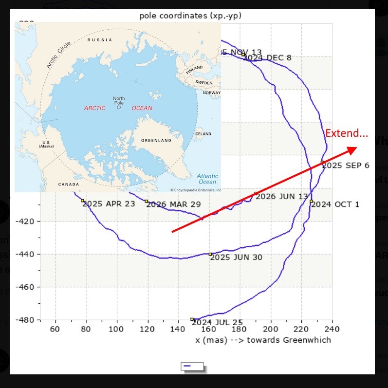
DRIFT Dashboard (Polar Motion Geometry And Context)
https://t.co/TuDUYQsmSF
Daily Pole-Step Bars From The Raw Earth Orientation Series
https://t.co/6640t7nH2P
@EcdoPrep@BraveCatGamer@sunfellow@ravi562114 Or more practically speaking. Take a big fat bar of weakly magnetized iron, and place a small very strong Neodymium magnet on a piece of paper somewhere, but not to close. Shake it and the smaller dipole will eventually orient itself to the larger but much weaker field. Compass!
@EcdoPrep@BraveCatGamer@sunfellow@ravi562114 It's a scale thing. The galactic or even IMF field is basically homogeneous near earth, while earths MF acts like a localized dipole, that (a) quickly fades away (as 1/r^3) near dipole. And (b) earth has a complex set of several magnetic sources. Earths B is just an average.