Our paper "Harvested area did not increase abruptly—how advancements in satellite-based mapping led to erroneous conclusions" is now published by @AnnForSci: https://t.co/CDYW1YO4BU
Code and data available here https://t.co/IbsSsydqvC. @_SLU @LukeFinland @UniNMBU @NIBIO_no
If you are building an #opensource single tree #forest 🌲 simulator, you should check this out https://t.co/ZceIOsxQfI We have just published our forest similator framework #SiTree, open-source and fully written in #R! The software is available at https://t.co/bU72hI6Bld
📢Join our team! We're hiring a permanent researcher with focus on modelling forest attributes relevant to managing forest fire risk using remote sensing data. Apply here: https://t.co/65xS1LjLlP @NIBIO_no @nfi100
1/3
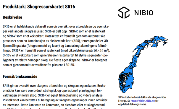
A new study describing the properties of Norway’s NFI forest resource map #SR16 based on airborne laser scanning has recently been published: https://t.co/tsmInRfRZV
Main points:
Predicted-R2: Volume=0.86, Height=0.92, Basal area=0.82, Biomass=0.84
En oppdatert produktbeskrivelse for 🌲🌳Skogressurskart #SR16 som inkluderer 18 ulike skogegenskaper samt usikkerhet er nå tilgjengelig: https://t.co/5hUamaYpcy
@NIBIO@NFI100
Göran Ståhl @_SLU ”Vi som tar fram officiell statistik upplever att en tydlig gräns passeras när man i debatten lättvindigt viftar bort den officiella statistiken till förmån för egna tolkningar eller resultat från enskilda forskningsprojekt.” https://t.co/piE626eyLo
100 years of National Forest Inventories in Finland in the core of a side event at UN's Forest Forum on Wednesday this week, remote participation for free, register to the event! https://t.co/uKnxBoa9H3 @LukeFinlandInt @KariTKorhonen@mmm_fi#Flagship
The Oslo UN-students invite to a seminar on 🌲🌳deforestation (in English). I'm looking forward to share some slides about deforestation in Norway. Thursday 17.00 CET: https://t.co/1sCebxqseO. More info: https://t.co/dfxHkVqkOu. @NIBIO_no @nfi100
📢New paper accepted @cdnsciencepub#CanJForRes: Improving🌲GHG inventories using @globalforests#GFW and NFI field data. Efficiency improved up to a factor of 3 when using one-time airborne lidar in addition https://t.co/k1MDGj8WYR. OA preprint: https://t.co/szSLAqyb4U @NIBIO_no
📢Short notice: INVENT final seminar Thursday 3 Dec: Improving C-stock change estimates in LULUCF-GHG inventories using field and remotely-sensed data following @IPCC_CH standards. Program: https://t.co/fAfNPWs48c. Registration: https://t.co/vO2EA5Hl2b @NIBIO_no @_SLU
Distribution of tree species as contour lines in Viken, Norway. Map created using open SR16 data from @NIBIO_no and open data from @kartverket. #30DayMapChallenge#ggplot2
Paper accepted: Mapping and estimating 🌲, pine, and 🌳forest for all of #Norway using @nfi100 and @ESA_EO#sentinel2 data. All details: https://t.co/heuHelAqoK. Map freely available: https://t.co/dU5UtdfBI2 @MapsNorway Thanks to @NIBIO_no @stefanopuliti @joh_schum @JohannesRahlf
New work by @nfi100 members empowered by the our #NFI repeated plot measurements, thanks to which we can calibrate direct biomass change models and ensure umbiased estimates.