..HEAT ADVISORY REMAINS IN EFFECT UNTIL 8 PM EDT SATURDAY...
* WHAT...Heat index values up to 103 degrees expected.
* WHERE...Portions of northern Delaware, central, northern, and
southern New Jersey, and southeast Pennsylvania.
* WHEN...Until 8 PM EDT Saturday.
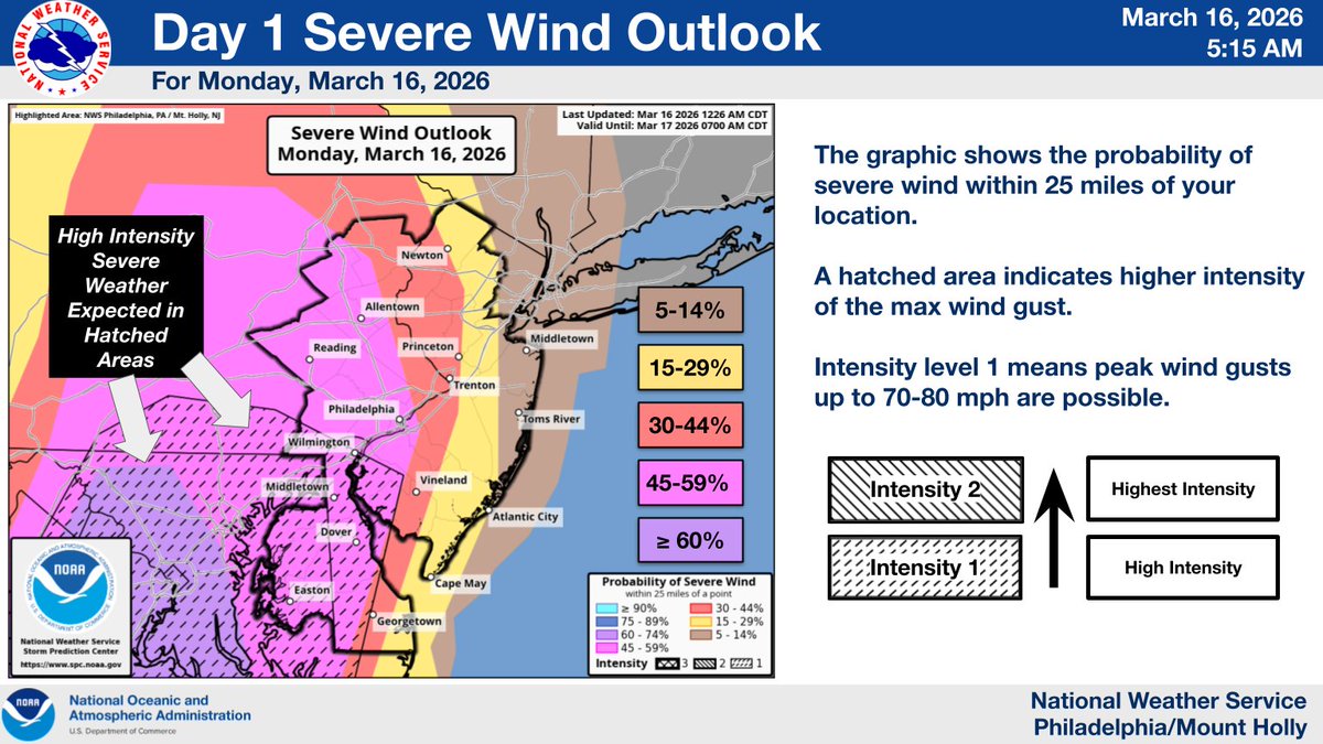
(1/2) Unsettled weather returns this week with scattered "pop-up" showers and thunderstorms on Monday. Isolated strong to severe thunderstorms are possible with locally damaging wind gusts and heavy rain. #PAwx#NJwx#DEwx#MDwx
Right now, the annual mass salmon migration is taking place at Brooks Falls in Alaska
During this period, dozens of bears gather at the waterfall, turning the area into a real feast.
The pleasant weather conditions continue through tomorrow. Lows tonight are in the mid 50s to mid 60s with a mostly clear sky. Highs on Sunday reach the mid 70s to mid 80s with more sunshine. Isolated showers and storms become possible Sunday night.
EXTREME HEAT WATCH REMAINS IN EFFECT FROM THURSDAY AFTERNOON
THROUGH SATURDAY EVENING...
* WHAT...Dangerously hot conditions with heat index values up to 110
degrees possible.
* WHERE...Atlantic, Cape May, and Cumberland Counties.
* WHEN..From Thursday afternoon through Saturday
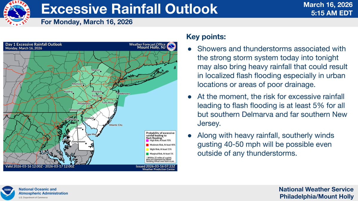
While we are starting quiet this morning, the day will not end that way. We still expect scattered severe thunderstorms along with some instances of flash flooding late this afternoon and this evening. Be weather-aware later today and tonight!
IMPACT DAY:
Severe storms are possible across the Piedmont Triad Monday afternoon. Showers and storms are expected to develop, and some could become strong to severe with damaging wind gusts and small hail. Stay weather-aware and have a way to receive warnings.
Find more on the s
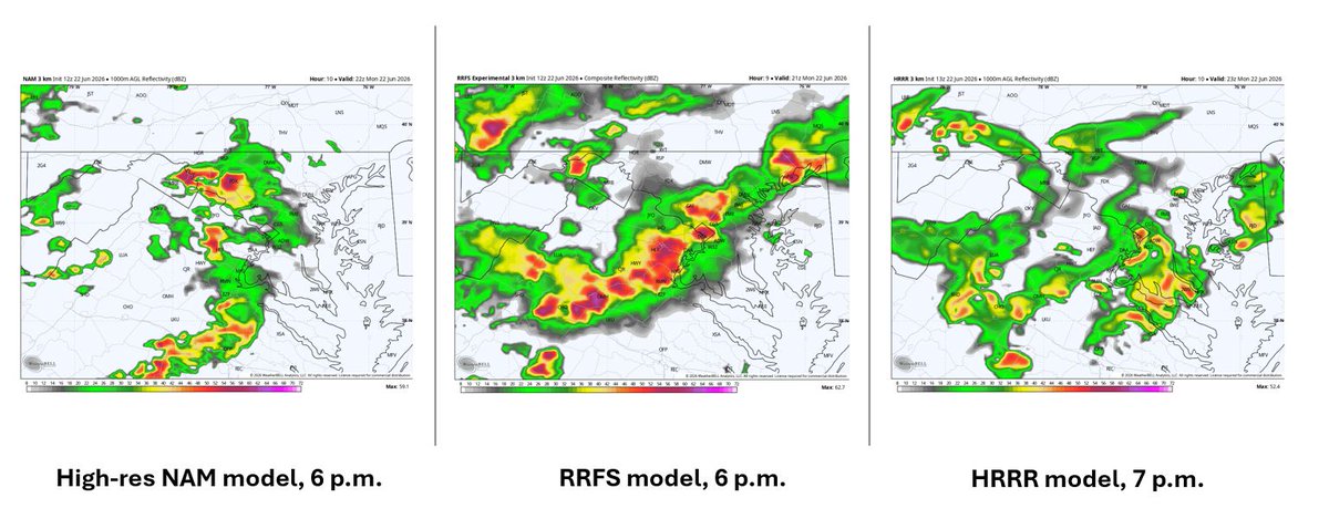
Closely monitoring potential for some strong to severe storms today (Monday).
* Most likely timing: 3-8p, prob 4-7p Beltway area
* Expect heavy rain, lightning, + poss damaging wind gusts in strongest storm
* Brief tornado poss in region; maybe highest chance toward N Md, Pa
Briefing at this link: https://t.co/Je5Dv4q1WI
⚠️⛈️🌬️ Severe thunderstorms & strong southerly winds will develop this afternoon & evening. Storms beginning as early as 2 PM, but peaking between 5-11 PM from west to east. Scattered tree damage & power outages possible. Stay weather aware today! #PAwx#NJwx#DEwx#MDwx
** MAJOR EASTERN PENNSYLVANIA WINTER STORM **
Overnight trends have pushed the heaviest snowfall now into eastern Pennsylvania as we see a rapidly strengthening low-pressure system off the East Coast Sunday afternoon through Monday. Over a foot of snow is now expected to fall in immediate Eastern Pennsylvania, with lesser amounts the farther west you are located. If you are planning to travel, I would put off travel conditions after 3 - 4 PM on Sunday, as that is when conditions will begin to rapidly deteriorate with falling temperatures and the loss of daylight. The worst of the storm will be all of Sunday night through much of Monday morning, before it begins to taper off to the east Monday afternoon.
On top of the snowfall, expect gusty winds. Across western and central PA, wind gusts of 20 to 35 mph will be possible. In the 8-12"/12-18" contour, wind gusts of 35 to 45 mph could be possible. These higher wind gusts will aid in the potential for whiteout conditions, especially late Sunday night through Monday morning. While a blizzard is not expected (needs to hit a certain criteria), blizzard conditions at times cannot be ruled out. ❄️
A final call snowfall forecast update with a blog post will be scheduled to release 4 - 5 PM this afternoon.
Stay tuned for updates!
Be winter-ready with @dmc_snow an exclusive provider of commercial snow & ice management across Pennsylvania, New Jersey, and Delaware. From distribution centers and warehouses to office parks, shopping centers, and retail stores, we keep your property clear and business running all season long.
National Weather Service
7:00 AM EST
February 21, 2026
Philadelphia/Mount Holly
February 22-23 Winter Storm - Briefing #4
For Delaware, New Jersey, Eastern Pennsylvania, and the Eastern Shore of Maryland
Important Updates
➔ Blizzard Warnings and Winter Storm Warnings issued
** SPRING-LIKE THAW POSSIBLE NEXT WEEK **
As we are beginning to climb out of deep winter, periods of warmer weather will become more and more likely over time. It appears the first more prolonged period of warmer weather will likely occur between February 17th and 21st. The CPC is highlighting our region for seeing above-average temperatures throughout this time frame. This would call for high temperatures in the mid-40s to mid-50s with overnight low temperatures in the low 30s to low 40s. After this time period, it does appear we return to more of a colder pattern with snow opportunities. Remember, we can never "call off" winter here in Pennsylvania until early April, but enjoy the periods of warmer weather as we begin to transition into spring! 🙂🌦️☀️