Peaking as a CAT 3, Hurricane Vance is now the 7TH consecutive Major Hurricane in the East Pacific.
Every storm that has formed here since mid-September has achieved winds of at least 115 MPH.
For comparison, the most intense Atlantic Season ever had 7 Major Hurricanes TOTAL.
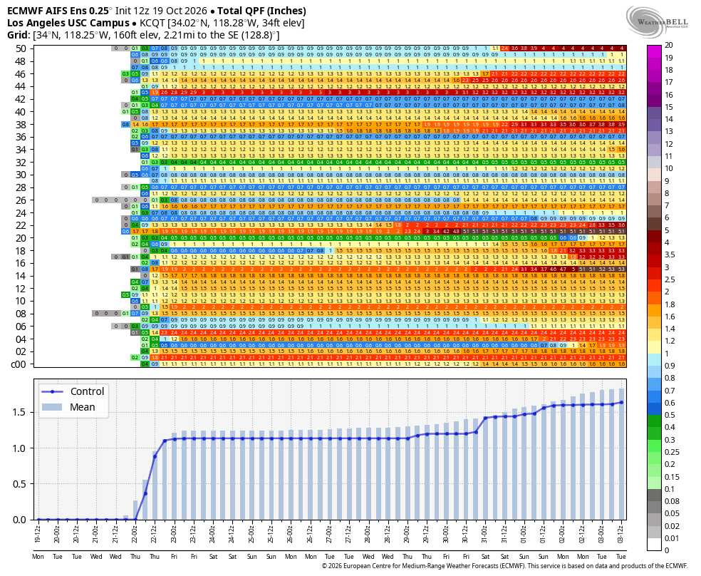
It's looking like a wet Halloween weekend for #SoCal.
Here is the 6-10 Day Outlook, indicating chances for above normal rainfall for next weekend.
* Moderate to high confidence in measurable rain
* Low confidence in exact timing and amounts
#CAwx
HEADS UP!!!!
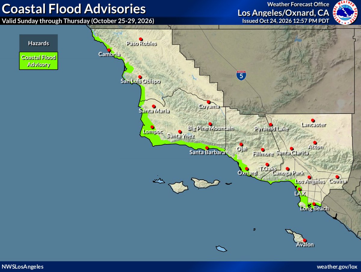
Minor to moderate coastal flooding likely Sun-Thu
* High tides 7.5 to 8.0 feet
- 1.0 to 1.5 feet above astronomical projections
* Moderate to significant beach erosion likely
* Small chance of localized upgrades to Warnings
#CAwx
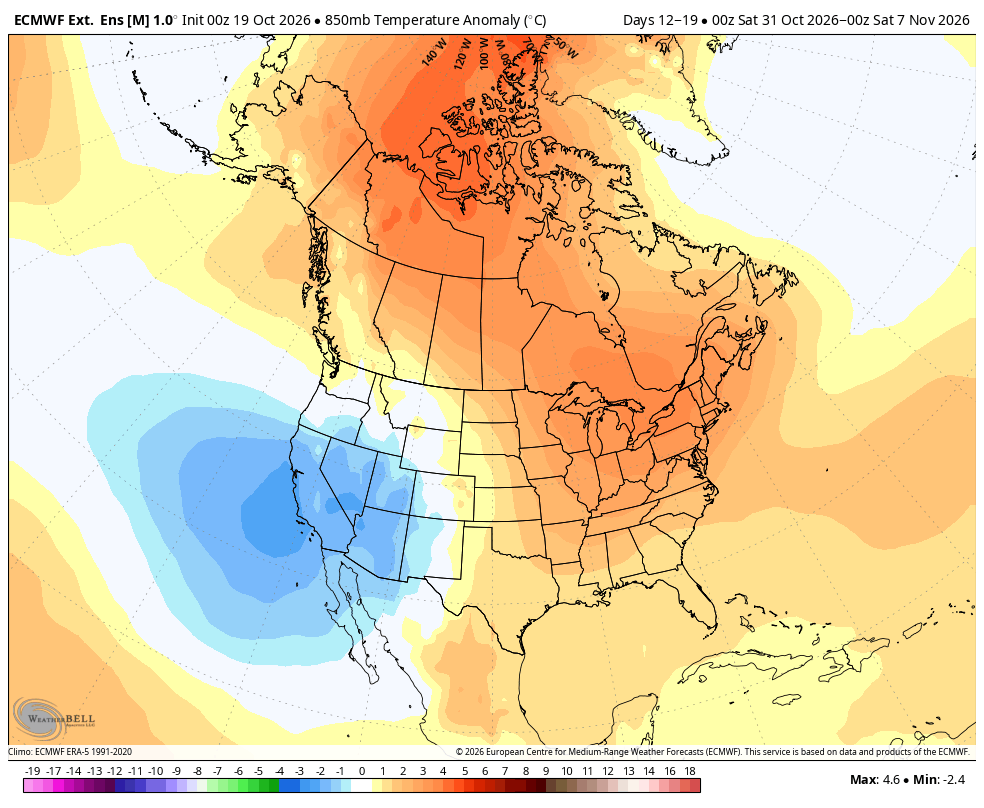
Things are about to get even more interesting across the West Coast. October has already delivered an impressive series of severe storms, but November could bring an entirely different level of activity. The developing pattern is becoming increasingly interesting, especially with a potential surge of tropical moisture originating near the Hawaiian Islands interacting with a low latitude Pacific low pressure system and a powerful jet stream.
From a meteorological standpoint, this combination could become quite significant. A strengthening Pacific jet stream, enhanced upper level divergence, and an increasingly organized moisture plume could work together to produce strong atmospheric lift and support the development of multiple storm systems. Should the subtropical moisture become fully connected with the approaching Pacific trough, the atmosphere could become much more efficient at producing widespread precipitation, with the potential for heavy rainfall, strong winds, significant mountain snowfall, and localized flooding depending on the eventual storm tracks.
What's particularly interesting is the potential for this broader atmospheric pattern to become established rather than simply producing one isolated storm. If the alignment between the jet stream, Pacific low pressure systems, and deep moisture transport holds together, we could enter a prolonged period of active and potentially very stormy weather heading into November.
There are still important details to resolve, particularly regarding the strength, positioning, and timing of these systems... Stay tuned for further updates.
Friday, October 23, 2026 1:50 PM : The Latest CPC just dropped shows very heavy rainfall affecting your Halloween weekend. There’s no cutting around this now. #CAwx#Californiastorms#ElNiño#halloween 🎃
Three people were rescued from raging floodwaters in Los Angeles’ San Fernando Valley Thursday morning, including a man dramatically hoisted to safety by helicopter, while a fourth person managed to escape the swollen channel before firefighters arrived. https://t.co/elJdyu92wm
Live emergency update on #tornado watch over much of Arizona. Supercells are firing all around Show Low in a much more unstable environment than yesterday. An intense tornado is possible today. Stay tuned to severe weather watches and warnings today
WATCH: Monster cell dumping golf ball size hail right now in North Phoenix. Severe thunderstorm warning expires at 4:30 p.m. and could bring 2.5" hail and 60 mile per hour winds. Live coverage starts at 4P! @FOX10Phoenix
A storm system headed for S California will bring widespread rain to the area late tonight thru Thursday. There is a chance of thunderstorms with potential for heavy downpours, lightning, strong wind gusts and a very small chance of a brief tornado. #CAwx
It may seem impossible, but another Major Hurricane (yes, actually) is set to form in the East Pacific and threaten the coast of Mexico.
What’s concerning about this next storm (whom will be named VANCE) is that he is forming to the south of the cold wakes stirred up by Hurricanes Polo, Rachel, Simon, and Trudy.
This could allow for very rapid intensification over untapped waters before a potential recurve into Mexico. Weakening would be likely in any sort of landfall scenario, and it’s still very early to know anything for sure, but this future storm appears to be one that needs to be watched closely.
A moderate storm is expected to impact Southern California Wednesday through Thursday. Peak timing for most locations will fall into the Wednesday afternoon through Thursday morning timeframe. See attached graphic for more information! #CAwx#LArain
CALIFORNIA PATTERN CHANGE, #ELNINO FORCING, THE POLAR VORTEX & THIS WEEK'S STORM.
Followers - Hope you are well. Most of you that know me personally, know that I had been back east for the past 2+ weeks, going back and forth from NY to State College. I was in the nor'easter in the northeast at the end of September, to the warm weather the first week of October in PA, to more rain, PV, and now mild and dry. Rollercoaster folks, and that is what I am predicting this fall and winter in the Conus. Use Grok, if you want a summary, cause you asked for it, it is a lot of info below.
Major pattern change out west, and cool and dry in the northeast.
Tonight thru the end of the week out west:
An upper low will move south just to the west of Monterey CA Tuesday night where it will likely sit and spin off the coast thru Thursday am, and deliver showers, Tstorms and much much cooler weather. Below is the breakdown in #california for each region.
NORCAL / BAY AREA
Rain arrives Tuesday evening and continues through Thursday. Current NWS estimates are around 0.10–0.25" in the North Bay, with 0.20–0.50" across much of the rest of the Bay Area. Some inland areas could see locally higher totals. Follow @nwsbay for detailed forecast
CENTRAL COAST
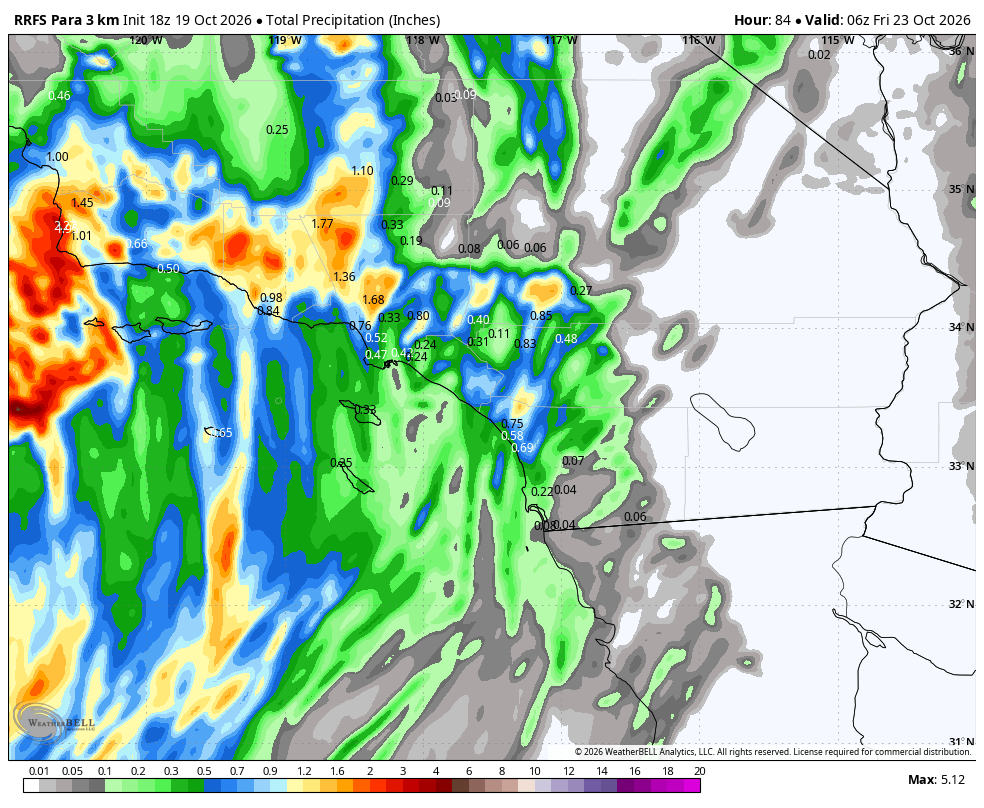
Around 0.33–1.00" across Monterey and San Benito counties, with locally heavier amounts possible. This area also has the better potential for thunderstorms, especially near the coastal ranges. See my RRFS model, as this looks to have a lot of the action around pt. Conception. @NWSLosAngeles
LOS ANGELES AREA, LAC
Rain develops Tuesday night or Wednesday and continues into Thursday. Roughly 0.75–1.00" is possible across many areas, with locally up to 2" in foothills and coastal mountain slopes. Again, I posted the Meteograms, and DTLA could get close to an inch...TBD. Again, follow @NWSLosAngeles
ORANGE COUNTY
The main window looks to be Wednesday into Thursday. Rainfall amounts should be in the general SoCal range, with locally higher totals near the foothills and coastal slopes. If you look at the image I posted, much less rain as you head south, but monitor @NWSSanDiego
SAN DIEGO
Wednesday into Thursday is the window to watch. Showers and a chance of thunderstorms are possible, but exact timing and totals remain less certain. Again, like the OC, much less rain as you head south, monitor @nwssandiego.
AND YES, THE SIERRA SHOULD SEE SNOW. BUT HERE'S THE CATCH.
This is an early-season, relatively warm system. Don't automatically assume a major snowstorm just because precipitation is showing up on the maps.
• Eastern Sierra / Mono County: Roughly 3–8" of snow is possible above 7,500–8,000 feet.
• Southern Sierra: Snow is expected to be largely confined to elevations above roughly 9,000 feet, with limited chances for heavier accumulations.
• Snow levels: Generally high, around 8,000–9,000 feet or higher in parts of the Sierra, varying by location and as the system evolves.
The higher passes could see some accumulating snow and slick conditions. This isn't the setup to automatically assume widespread snow at the lower mountain elevations.
Monitor @opensnow for the snow report, as resorts are still closed and need colder temps to start making snow. This will be the theme this year, as high snow levels is what I am looking at more often than not, then these big #elnino storms come thru.
Now, let's zoom out.
The bigger question isn't whether California gets one storm. It's whether we're starting to see a more persistent change in the large-scale circulation as #ElNino atmospheric forcing becomes more influential.
El Niño isn't simply warmer SSTs in the equatorial Pacific. It's about how the atmosphere responds.
Changes in tropical convection can influence the Walker circulation and generate atmospheric wave responses that affect the Pacific jet stream, Rossby wave patterns and the placement of ridges and troughs across North America. That's the connection I'm watching.
BUT... the polar vortex is another piece of the puzzle.
IMO, periods of polar-vortex disruption could complicate the El Niño response ON AND OFF this fall and winter. Changes in the stratospheric vortex, planetary-wave activity and potential stratosphere-troposphere coupling can influence the larger circulation. @judah47 and I discussed this at length this past summer and we both feel that this, along with the PDO, QBO, SSW, are going to be the fly in the ointment for how much sustain cold is out west and how disruptive they will be to the pacific flow of the EAJ.
Now, that doesn't mean every vortex disruption produces a California storm. The resulting pattern matters: where blocking develops, how the Pacific jet responds, and whether a West Coast trough can establish itself and break down the ridge. This is the question, as this could be a similar pattern to last winter, when we had 100 degree heat in DTLA in Mid March, which decimated the snow pack out west.
We could see active stretches followed by breaks, shifts in the storm track and different outcomes between Northern and Southern California.
And for the Sierra? Precipitation alone doesn't tell the story. Snow levels, temperature profiles, storm track and available cold air matter just as much.
El Niño provides a background influence. It does NOT dictate every individual weather pattern.
I'm watching whether the tropical Pacific forcing becomes more established and how the polar vortex and midlatitude circulation modulate that response as we move deeper into winter.
One storm doesn't make a season. One model run doesn't make a forecast.
My winter forecast will be released the on November 15th. By then #california & #socal will have gotten some rain/snow but not looking at huge totals as of now.
Let's see how this plays out in the next few weeks. For now, I will keep you posted throughout the week on trends and how this system evolves and produces what the models are showing.
#CAwx #SoCalWeather #ElNino #PolarVortex #SierraSnow #wxtwitter #socal
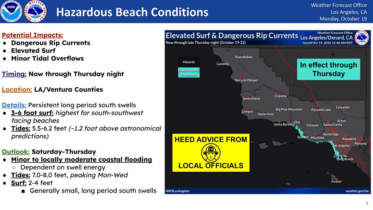
Hazardous Beach conditions will continue through the foreseeable future. Suggested actions: Stay back from the water’s edge, Never turn your back to the ocean, Stay off rocks and jetties, and Always swim near a lifeguard. See attached graphic for more details! #CAwx
A farmer, tired of rats destroying his crops and stealing his grain, came up with a clever but cruel plan. He threw a dead pig into a deep, abandoned well. Attracted by the smell, nearly 80 rats rushed into the well to feast on the carcass. At first, everything seemed wonderful. There was more than enough food for everyone, and the rats ate until they were satisfied.
But when the food was gone, they discovered something terrifying. The walls of the well were too steep to climb. They were trapped. Days passed, and hunger turned into desperation. Desperation turned into aggression. The rats that had once eaten peacefully beside one another began fighting for survival. Eventually, they began killing and eating each other.
One by one, their numbers dwindled until only a single rat remained. Its eyes were bloodshot, and it had survived by consuming its own kind. Then the farmer returned, lowered a rope into the well, and rescued the last surviving rat. But he didn't save it out of kindness or compassion.
The farmer knew the rat had learned to survive by hunting other rats. When he released it into his fields, it would continue killing its own kind instead of eating his grain. The farmer had turned his enemy into his greatest weapon.
And that is the lesson of divide and conquer. Those who control the trap don't need to fight the battles themselves. They simply create the conditions in which others turn against one another.
The rats believed their enemies were the other rats. They never realized that the true enemy was the farmer who had put them there.
The greatest danger isn't always the enemy standing in front of you. Sometimes it's the one who created the conflict and stands quietly watching you destroy each other.
Before you turn against your neighbor because of their political beliefs, ask yourself who benefits from keeping Americans divided. While we fight each other over Republican and Democrat, we may be overlooking those who profit from the conflict. Perhaps the real question isn't which side you're on, but who built the well—and why they want us fighting at the bottom of it.
"A welfare check on a quiet street turned into something Sheriff Daniel Hayes will never forget. Neighbors hadn't seen the young mother at 214 Willow Lane for two days. They told dispatch a baby had been crying on and off, then suddenly everything went silent. Silence was what worried them most. Hayes, a 20-year veteran, arrived expecting a routine knock and a tired parent who simply hadn't answered the door. He knocked hard and announced himself. No movement. No sound. He forced the door open and stepped inside, calling out as he moved down the hallway. The air felt heavy. A faint smell of heat and stillness hung in the rooms. In the back bedroom, he found a baby girl lying in her crib. She was weak and dehydrated, but her eyes were open. When she saw him, she didn't cry. She just stared. "You've been around a long time, haven't you?" he said softly as he moved closer. In the next room, he found her mother. She had passed away in her sleep from a sudden medical event. Later reports estimated she had been gone for at least 36 hours. The baby had been alone the entire time. Training took over first. Hayes checked her breathing and pulse, then called for medical assistance. After that, he carried her outside to the front porch, away from the scene inside. He lowered himself into an old wooden chair and held her carefully against his chest. "It's alright," he murmured. "I'm here now. You're not alone right now." The child's small fingers wrapped weakly around his shirt. Her head rested under his chin as he waited for the ambulance. "You held on so long," he whispered. "We're going to get you warm. We're going to." His partner captured the moment from a distance. The photo shows a seasoned sheriff sitting on a porch, cradling a baby as tears fall down his face. Years of experience hadn't prepared him for the weight of that afternoon. The girl, later named Lily, recovered at the hospital. Hayes and his wife opened their home to her while relatives were located. When her grandparents were finally found, the handoff was quiet and full of emotion. Now she visits every month. The uniform that carried her out of that house is no longer just a symbol of authority to her family. Some calls end when the report is filed. Others change a life long after the sirens fade.
LEDs are more energy-efficient, yet they also pose a threat to human health.
For the past two decades the global shift toward energy-efficient light-emitting diodes has drastically altered how we light our homes and offices. While highly beneficial for reducing electricity bills, these lights emit a narrow spectrum dominated by short blue wavelengths and entirely lack the long-wavelength red and infrared light found in natural sunlight and older incandescent bulbs.
Emerging research led by Professor Glen Jeffery at University College London shows that our cells’ powerhouses, the mitochondria, rely on these missing red wavelengths to function. Without them, mitochondrial respiration is suppressed, leading to systemic infrared starvation that can disrupt cellular energy production, cause chronic inflammation, and accelerate aging.
This lack of natural spectrum light is more than a matter of eye strain; it has deep metabolic consequences. Studies show that exposing the body to specific red and near-infrared light stimulates mitochondria to consume more glucose and oxygen, dramatically reducing blood glucose spikes and regulating insulin levels. Conversely, prolonged indoor exposure to red-deficient, blue-heavy LEDs is linked to metabolic dysfunction and cellular degeneration, contributing directly to chronic conditions such as type 2 diabetes, cognitive decline, and vision loss.
As public health researchers warn of this modern environmental hazard, experts suggest reintroducing balanced full-spectrum lighting or simple red-light exposure to help restore our natural metabolic rhythms and protect long-term health.
[Barrett, E. M., & Jeffery, G. (2026). LED lighting (350-650nm) undermines human visual performance unless supplemented by wider spectra (400-1500nm+) like daylight. Scientific Reports, 16(1), 3061. DOI: 10.1038/s41598-026-35389-6]