Live emergency update on another BIG day for severe weather across the Corn Belt. Supercells will be capable of all hazards this evening along the outflow boundary from northern Illinois into Indiana
@accuweather
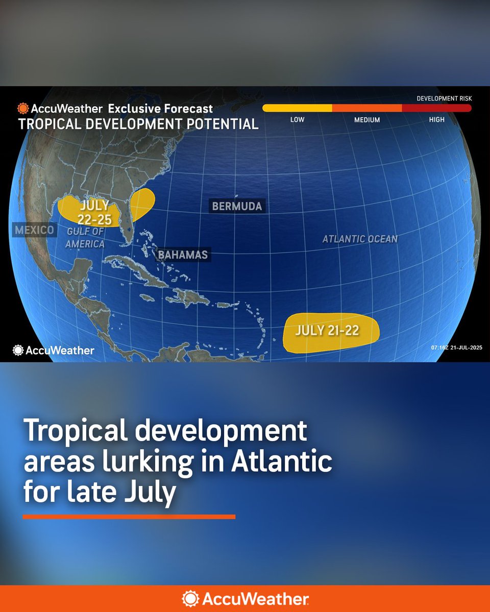
While the Caribbean remains quiet, there are areas of the Atlantic basin, especially some close to the United States that bear watching in the coming days for tropical activity. https://t.co/2GOmTJtRgQ
BREAKING: Malcolm-Jamal Warner, who played Theo Huxtable on "The Cosby Show," dies at 54 in an accidental drowning in Costa Rica, authorities say. https://t.co/yGfqPxwCZx
RADAR 7/21 12:15PM | Scattered showers and storms are beginning to develop and will continue to become more widespread throughout the afternoon and evening.
Gusty winds and periods of heavy rain are possible so watch for localized flooding.
HEAVY RAIN & FLASH FLOOD CONCERNS
Here's what the Weather Prediction Center is sayin....
"DISCUSSION...Scattered clusters of heavy thunderstorms are developing in the warm sector ahead of a cold front along the middle Ohio Valley with scattered storms over the central to southern Appalachians. An axis of 2" PW extends east along the Ohio River to West Virginia with elevated moisture continuing across the Apps. Instability is more than sufficient for continued heavy development with MLCAPE 2000-3000 J/kg in the lower elevations and above 1500 J/kg at higher. Deep layer Wly flow around 20kt is present across the area which will aid orographic lift west of the Appalachian Crest and allow training as the general orientation of the activity is west-east.
CAMs including recent HRRRs and RRFS have development continuing at least through mid-evening. Max 3hr totals of 2-4" can be expected which is well above the general FFG of 1.5" in 3hr in this vulnerable area of terrain which has been wet in general this summer. Scattered flash flooding can be considered likely."
@pipewrenchplumbinghvac has been in business since 2001, They have proudly delivered top-notch plumbing and HVAC services to the greater Knoxville community. Whether you need repairs, replacements, or maintenance, we offer same-day service to quickly address all of your plumbing, heating or cooling needs. You can trust the experts at Pipe Wrench for reliable, long-term solutions to any problem that arises. And remember, Same Day Service Guaranteed, or your visit is FREE!
So far in 2025, nine tornadoes have had tornado emergencies issued for them:
- Fremont, Missouri EF3 (165 mph) | March 14
- Tylertown, Mississippi EF4 (170 mph) | March 15
- Lake City, Arkansas EF3 (160 mph) | April 2
- Slayden, Mississippi EF3 (160 mph) | April 3
⬇️
Demolition experts safely imploded the 500-foot and 800-foot stacks at the retired Bull Run Fossil plant. After 61 years of service, the plant was retired in 2023 — and now we’re looking ahead. Now, we’re focused on what’s next—using this site to pursue new energy technologies for expanding American power generation. 🇺🇸
***NOAA suspending critical hurricane-forecasting satellites***
This is not a political post – but rather a notice that a vitally-important satellite used to probe and track hurricanes will be discontinued within a week.
This will have noticeable negative impacts on hurricane forecasts and forecasting in general.
The National Oceanic and Atmospheric Administration announced Wednesday that they will be cancelling the ingest, processing and distribution of data from the Special Sensor Microwave Imager Sounder (SSMIS).
"This service change and termination will be permanent," wrote NOAA.
SSIMS is flown on the United States Air Force Defense Meteorological Satellite Program (DMSP) F-16, F-17, F-18 and F-19 satellites; the latter stopped producing useful data in February of 2016, but the first three satellites are vital.
The agency did not elaborate on why the otherwise-usable satellites will be discontinued. There is no replacement scheduled.
The SSMIS satellite are extremely important; as a forecaster, I use the constantly. The microwave satellite imagery allows us to peer under the overcast of a storm, probing the inner structure of a tropical cyclone. It's especially important at night. Visible and infrared satellite imagery capture cloud top details, but not what's happening *inside* a named storm.
By resolving changes in a cyclone's inner structure, we're able to see how a storm is evolving – and potentially rapidly strengthening. The absence of this data creates an enormous hole in hurricane forecasting.
We may be less knowledgeable of changes in a storm's strength.
Early in a storm's life cycle, microwave satellite imagery also helps us pinpoint where a center of circulation is located. "Pinning the tail on the donkey" is extremely important, because getting the center point correct means better model output. If we're off a bit early on, then that error grows exponentially the farther out we forecast for.
Please be aware that this change can and will have a negative impact on the forecasts relied upon by Americans living in hurricane-prone areas.
MAJOR #TORNADO THREAT TOMORROW evening in the Dakotas including Bismarck to Fargo!
A classic northern Plains #tornado setup is forecast tomorrow evening with a broad belt of unstable, moist easterly flow beneath strong westerlies. June moisture will be in place across the northern Plains through Upper Midwest which will fuel big instability. This is the type of setup that creates the slow-moving mega wedge #tornado.
The Dominator 3 is heading north
SIGNAL FOR ACTIVE EARLY JUNE FOR TORNADOES CENTRAL AND SOUTHERN PLAINS
The CFS forecast supercell parameter product from the Northern Illinois university team shows a robust signal for severe weather including tornadoes across Nebraska, Kansas and Oklahoma during the June 4-11 window. This pattern likely will start by June 2-3 and will including significant severe weather. Stay tuned
Check out this camera angle of the #tornado intercept with @localmanweather capturing the impact of the violent #tornado core. It spun the Dominator 3 while in park either 460 or 100 degrees. I thought we were airborne for a split second but the Dom3 did its job! @WillClay25 whipped up the air cannon with a direct hit on the first launch. Insane patience to wait until a half second before impact
Watch the full video here: https://t.co/I5yQLvvL1j