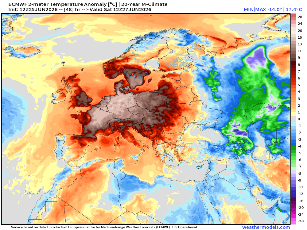
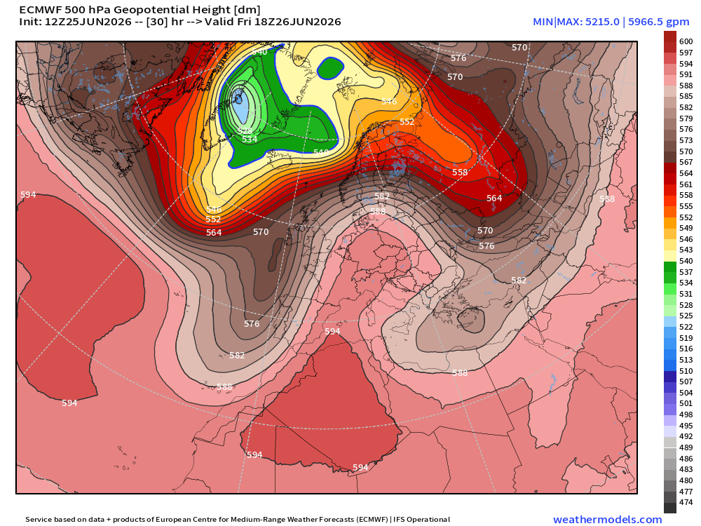
“Omega block” describes the shape. But let’s not lose the plot: this is another globally-warmed heat dome setting up over Europe, with 500-hPa heights potentially exceeding all observed records across a huge swath of the continent.
That is the atmospheric backdrop for another round of potentially record-breaking heat.
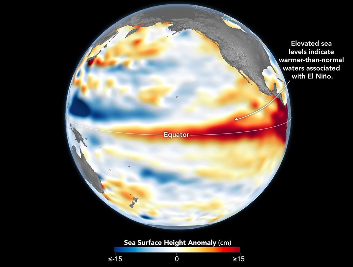
Recently @NOAA announced the return of El Niño, as ocean temperatures in the tropical Pacific remained above average for several months. NASA scientists are seeing a complementary sign of El Niño: rising sea levels as warmer ocean water expands.
The worst heat dome in almost 500-years is bringing Europe to its knees with widespread 100°F temperatures & worsens into the weekend for Germany, Poland and Ukraine.
Most European🇪🇺 population does not have access to air conditioning or can't afford it = "cooling inequality"
🚨 Introducing Project Cosmos, the world’s largest database of climate change research.
Carbon Brief has mapped the academic literature and evidence that underpins humanity's knowledge of climate change.
The Cosmos database includes 1.8 million studies.
Explore the database here ⬇️
https://t.co/sVbaZVsHo4
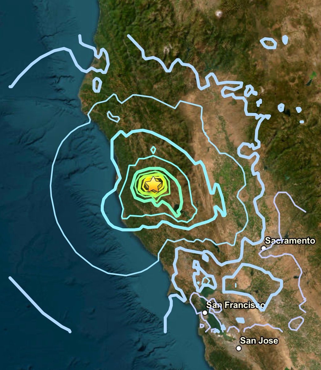
The Earth just experienced FOUR significant earthquakes in a single day.
First, it was a Magnitude 5.6 in California’s Redwood Valley.
Then, 7 hours later, a devastating “double” quake inflicted massive destruction in northern Venezuela. The first one at Magnitude 7.2, followed by an even larger Magnitude 7.5 only 39 SECONDS later.
Finally, a mere 25 minutes after the Venezuela twins, a Magnitude 6.9 marine earthquake struck offshore of Kuji, Japan.
Very rare to see this much seismic activity across the globe in such a short period of time.
You can just do things:
Someone created this open-source satellite imagery app, Earth View, that lets you explore the latest imagery from anywhere on the globe.
It comes with default NASA imagery which is only a day old, feature to add the 'Sentinel Key' by ESA to get detailed imagery down to 10m per pixel and also radar imagery for live natural events like earthquakes, storms, volcanoes, time-lapse views and more.
Great stuff!
It is now officially summer in the Northern Hemisphere!
Yesterday's #SummerSolstice marked the start of the season, and this yearlong view of Earth's changing sunlight angle is provided by @NOAA's #GOESEast (#GOES19) 🛰️. Made from images collected daily at 11:50 UTC, this loop shows how our planet's tilt drives the seasons.
Introducing: The Earth Simulator from @Mycosoft
https://t.co/g7P45BiTv2
Earth Simulator is Mycosoft’s living environmental intelligence map — a nature-first Common Relevant Environmental Picture for seeing Earth as one connected system.
Because of El Niño Costero, unusually warm waters along Peru's coast are allowing crocodiles to expand their range southward from near the Ecuadorian border.
In some areas, the ocean is more than 7˚C (12.6˚F) warmer than average.
🌎 NOAA has officially declared the onset of El Niño
El Niño is the warm phase of ENSO, during which surface waters in the central and eastern tropical Pacific become warmer than usual.
As the distribution of warm water in the Pacific shifts, atmospheric circulation also changes, including the position of the jet stream and storm tracks. This can influence temperatures and rainfall thousands of kilometres away.
Current seasonal forecasts suggest that El Niño will continue to strengthen through the rest of the year. According to NOAA, there is a 60% chance that sea surface temperature anomalies in the central and eastern tropical Pacific will exceed 2 °C by the end of the year. This episode could therefore become very strong and rank among the strongest events on record.
Typical impacts of El Niño:
• globally: an increase in the planet’s average temperature
• more rainfall: western and southern South America, parts of East Africa, and the southern United States
• drier conditions: northern and eastern Australia, Indonesia, parts of Southeast Asia, southern Africa, and parts of Central America
• South Asia: the southwest monsoon is often weaker
• tropical cyclones: less favourable conditions in the Atlantic, a more active eastern and central Pacific, and typhoon formation in the western North Pacific often shifting farther east
Prepare for takeoff. ✈️ Flight simulator is now available globally on web to all users. https://t.co/hQP0No142P
We've recently added many our most powerful professional desktop features to web. Elevation profiles, new import types, but there's always been one other feature you've been asking us to add to the web version of Google Earth, just for fun...
Where will you fly? Share your best maneuvers, views, and flyovers with us!
El Niño has officially begun, and it's expected to intensify into a historic "Super" El Niño that could shift weather patterns around the world https://t.co/nv0TH4ksz9