🔥 A wildfire near la Vall d'Uixó 🇪🇸 burned over 7,200 hectares by 27 July.
🛰️ This #CopernicusEU Sentinel-2 comparison shows the fire in natural and false colour, revealing smoke, active fire fronts and the burn scar.
🔗 https://t.co/a2ouSbe0Iv
#ImageOfTheDay
Super El Niño is beginning to reshape the atmospheric flow. After a clear July interference, new August forecasts show the Pacific forcing expanding into weather patterns across the United States, Canada, and Europe, with stronger impacts expected toward Fall and Winter
https://t.co/mzd73GtCqk
⚠️ It seems the fire near Bordeaux has re-intensified based on satellite imagery. Unfortunately, this is happening right before the hottest day of the heatwave in this part of France, with a high temperature over 40°C expected tomorrow (Wednesday). Extreme heat makes it even more difficult for firefighters to do their job, and wind gusts between 35-45 km/h sweeping off the Bay of Biscay arrive tomorrow afternoon.
#Europe is burning!
Impressive @CopernicusECMWF CO Total column map of July 26 showing the CO plume generated by #wildfires in #France and #Spain.
More than 325,000 people have been evacuated, while over 42,000 hectares have burned and #smoke plume crossed the Mediterranean.
Despite the recent temporal refreshment, it is far from over. Extreme Heat furnace delivers 40+ °C for many countries as July ends and August arrives next weekend:
https://t.co/Afc1OnJXpT
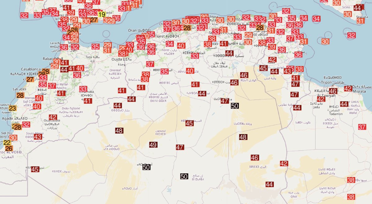
🔥 Another extremely hot day in North Africa with many stations close to their all-time records.
ALGERIA 🇩🇿
🌡️50.0°C In Salah
🌡️49.8°C Adrar & Hassi Messaoud
🌡️48.7°C Timimoun
🌡️48.5°C Rhourde Nouss
🌡️48.3°C Beni Abbes
TUNISIA 🇹🇳
🌡️Tmin 36.9°C Remada = all-time record
Prudence à l’orage qui est en train de s’approcher de la Haute Corse. C’est surtout le cap Corse, le secteur de Bastia et la côte nord qui seront touchés.
Attention à la forte activité électrique, aux fortes pluies, rafales de vent et quelques chutes de grêle.
🇪🇸 ESPAGNE : Le gigantesque incendie dans la région de Madrid est désormais "impossible à éteindre", annonce le gouvernement régional. "À l'heure actuelle, l'incendie est au plus fort".
HIGH RISK has been issued across portions of Italy and the Adriatic Sea, with highlighted areas where the most robust severe weather storms will develop on Sunday:
https://t.co/BSqjWmHRcu
Temperatures mínimes de divendres 🌡️
La passada nit ha sigut extremadament càlida. Per una banda, s'han registrat mínimes de 28-30 ºC en algunes zones de muntanya (Balones, Banyeres, Biar, Benimassot..). Per altra banda 26-28 ºC en bona part de la costa amb humitats del 90%.
Temperatures màximes de dijous 🌡️
En moltes comarques hem tingut el dia més càlid de l'any i s'ha arribat als 45 ºC a Villena, Orihuela i Quesa. La sensació de calor per la humitat ha sigut realment dura. I al litoral entre Alacant i Torrevieja hem tingut un esclafit càlid i sec
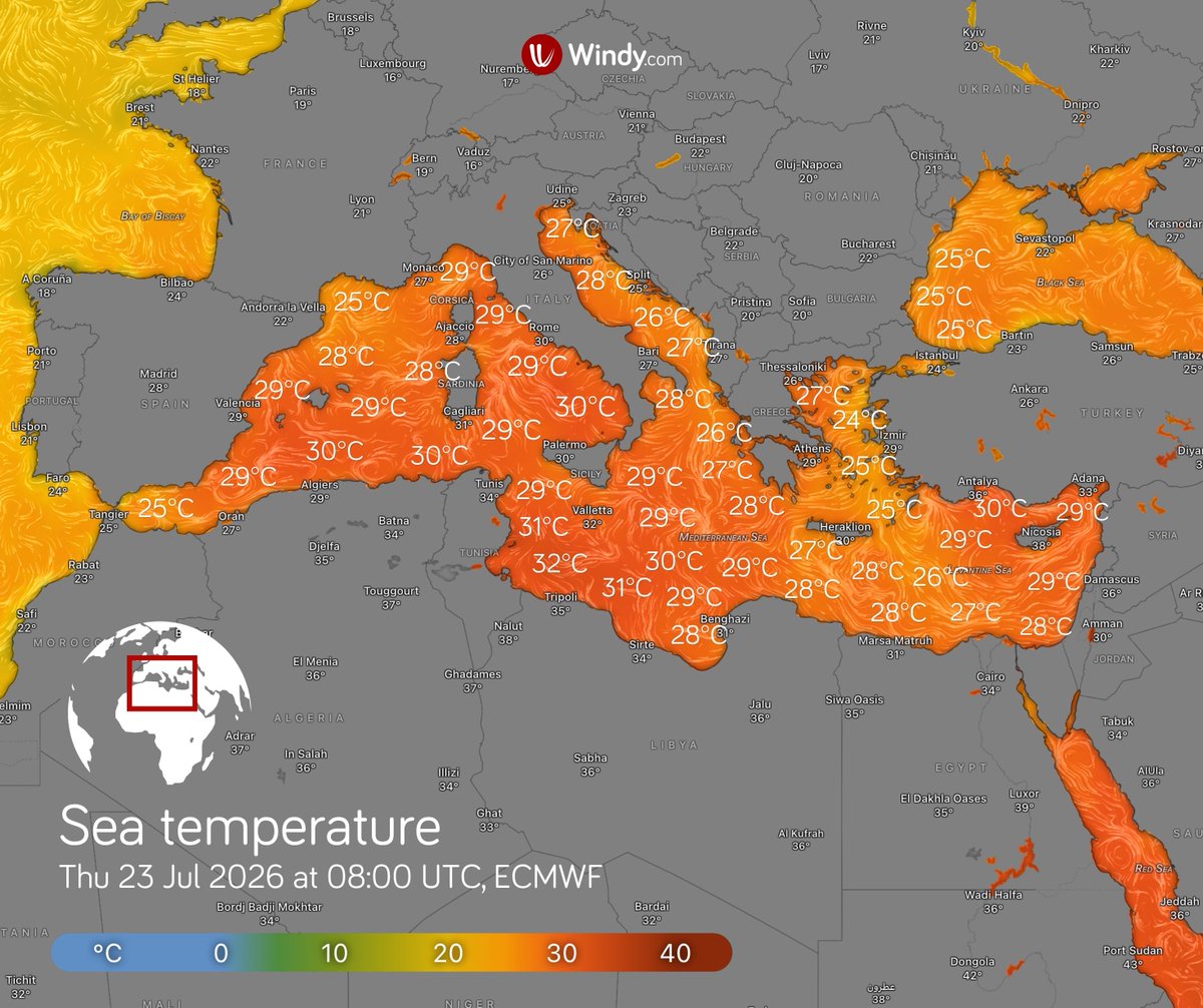
🌡️ The Mediterranean is experiencing an extreme marine heatwave
Sea surface temperatures are above average across almost the entire Mediterranean. On 21 July, the basin-wide average reached 27.71 °C, which is 2.91 °C above the long-term average for that date (Copernicus Marine Service).
The largest anomalies are currently occurring in the western Mediterranean:
• off the coasts of Algeria and Tunisia and along the western coast of Libya, the water is locally more than 5 °C warmer than usual, with temperatures reaching almost 32 °C
• around Corsica, Sardinia and Sicily, and along the western coast of Italy, anomalies are around 4 °C, with water temperatures often between 29 and 30 °C
• off the coast of southern France, the water is more than 4 °C warmer than usual, with temperatures around 26 °C
Water temperatures in the western Mediterranean are therefore locally reaching levels more typical of the eastern part of the basin.
A marine heatwave is persisting across large parts of the western Mediterranean and is locally classified as severe to extreme.
A marine heatwave occurs when sea temperatures remain above the 90th percentile of the usual values for a given location and time of year for at least five consecutive days.
⛈️ Warmer seas increase evaporation and provide more heat and moisture to the atmosphere. Under favourable conditions, this can support more intense thunderstorms and heavier rainfall.
🐠 Prolonged warming also places marine ecosystems under stress, can cause mass mortality of marine organisms, and may alter the distribution of species.
The 2026 Super El Niño is strengthening rapidly, with several forecasts pushing the event into record-breaking territory. The atmosphere already shows broad circulation changes, with amplified early Winter 2026/2027 signals emerging in the latest forecasts across Europe, the United States, and Canada.
https://t.co/3lg7A0qGVI