Your team grew. Now your SkyFi account can too. 🛰️
SkyFi Enterprise: one parent org, independent sub-teams underneath. Each with its own:
🔐 Role-based access
🧱 Fully isolated data
💳 Separate budgets & limits
Same virtual constellation. Pay-as-you-go. No contracts.
See how it works: https://t.co/0eTFlgl93S
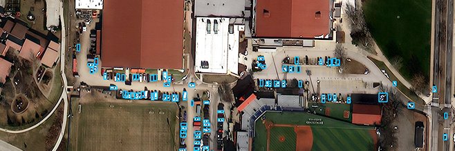
One of the largest AI infrastructure builds is rising, and its progress can be followed from above. SkyFi's multi-provider network combined satellite imagery from Vantor, Planet, and Satellogic with Vexcel aerial as fine as 7.5 cm to track the Stargate campus in Abilene as it grew from open ground into a large-scale complex.
See the world in a new dimension.
@vantortech Vivid Terrain brings high-resolution 3D terrain, elevation, and analytics products to SkyFi.
Move beyond flat maps with surface models, point clouds, true ortho imagery, elevation models, building data, vegetation insights, and land use classifications.
Automatic Ordering for Watch AOIs is now live on SkyFi Pro.
Save your area of interest, set imagery filters and budget, and SkyFi will automatically order and deliver new coverage as it enters the archive.
No more checking back for new imagery.
WMTS Streaming is now live on SkyFi 🌎
SkyFi users can now stream high-resolution satellite imagery directly into ArcGIS and QGIS as live map layers.
Available now for Pro and Enterprise customers: https://t.co/5vtKpbKXJo
We’re hiring across three exciting roles at SkyFi:
🔸 Customer Success Associate
🔸 Product Designer
🔸Capture & Proposal Manager
Explore open roles and apply: https://t.co/XoNn8VSTHB
SkyFi is heading to the @neudatalab New York Summer Data Summit 2026.
If you’re attending, make sure to connect with Chris Hyde to talk about how accessible Earth observation data and analytics can support better decision-making across industries.
See you in New York!
The eyes of the world are upon you.
To the Americans who gave everything here and to the Allies who fought beside them 82 years ago today: we remember.
#DDay@usabmc
Featured in @Newsweek: A satellite image delivered by SkyFi revealed an unidentified object at Scarborough Shoal, one of the most contested reefs in the South China Sea.
The analysis from @SeaLightFound indicates the object appears to be under 10 meters in diameter. Whether it is fixed or floating remains unclear.
Read Newsweek's full report: https://t.co/GqIryC1hoK
Monitoring China's Fourth Aircraft Carrier from Space 🛰️
This timelapse of Dalian Shipyard follows the vessel taking shape, with the most recent capture on May 8, 2026. Watching the same location over time surfaces the patterns, pace, and activity a single scene misses, which is what makes satellite imagery useful for monitoring major developments.
Monitor any location over time on https://t.co/PJr4waApOT
SkyFi has advanced to the Mission Track of NATO DIANA's Defense Innovation Accelerator for the North Atlantic (DIANA).
As one of five companies selected from DIANA's 2026 cohort of 150 innovators, and chosen from over 3,600 proposals across 24 NATO countries, SkyFi is now entering the adoption phase of the program.
In the coming months, we will refine our AI-enhanced geospatial decision-support platform alongside NATO end-users, aiming to broaden coalition interoperability and strengthen decision support in contested, denied, and austere environments.
Thank you to @NATO DIANA for the opportunity to support the readiness of all member nations.
Read our full announcement 👉 https://t.co/0VY043oL3c
This Memorial Day, we pause to honor those who gave everything in service to our country. 🇺🇸
To every family carrying a name today, we remember them with you, and we are grateful.
SkyFi is at SOF Week! Come meet the team and learn how our Sovereign Intelligence Platform for US Special Operations Command is brining satellite imagery to the tactical edge through our ATAK plugin.
Read more 👉 https://t.co/abRLcVHQpd
Stop by booth 5606 in the Marriott Water Street Grand Ballroom during @GlobalSOF Week.
#SOFWeek #SOFWeek2026 #USSOCOM
Following reported Iranian drone strikes and a separate industrial fire at the Fujairah Oil Industry Zone in recent months, SkyFi tasked satellite imagery to provide updated visual context of the area.
The image captures key infrastructure across the zone, including industrial facilities, storage tanks, and the surrounding terminal area, helping analysts build a clearer picture of conditions on the ground.
For energy, defense, insurance, logistics, and risk teams, this is the value of rapid satellite tasking:
A verifiable visual layer while the situation is still unfolding, and a better understanding of downstream impacts.
Heading to SOF Week? Come find us! 👀
SkyFi will be at Booth 5606 from May 18 to 21.
Meet @lukefischer, @therealkmgvd, Whitney, and Ivan to see how teams can access on-demand satellite imagery, multi-sensor data, and built-in analytics through one platform and on ATAK. 🛰️
See you in Tampa!