August 16: 11:20AM AST @53rdWRS find #Erin is now a Category 5 Hurricane with maximum sustained winds of 160 mph. Visit https://t.co/tW4KeGdBFb for the latest
#BREAKING Reportedly, a vessel exploded around 5:45 pm w/ 13 ppl aboard, Mon. near the New River Triangle, Ft. Lauderdale. Multiple injuries reported. @browardsheriff, @MyFWC, @USCG Sta. Ft. Lauderdale & AirSta Miami rescued & transferred the 13 ppl to EMS. Investigation ongoing.
All eyes are on the skies today for most of central and SE Minnesota along with western Wisconsin and northern Iowa. Anywhere in the black hashed area is at risk for strong tornadoes which is basically all of Wisconsin. The timing is between 4-10pm for the predicted area.
Update for tomorrow’s severe weather in MN. The area at risk for tornadoes has gotten larger and includes all the of the Minneapolis/St Paul metro area! Anything inside the hashed area is at risk for large or long lasting tornadoes! This will be a major tornado outbreak for MN!
Mondays severe weather predictability is at a 45% chance which is one step down from the highest predicting percentage that the SPC can predict 3 days out. This is not a system to take lightly, MN, WI and IA will definitely see tornadoes. Have a plan in place to seek shelter!
Taking a look at the long range severe weather forecast, the @NWSSPC has issued a chance for severe weather in days 5 and 6 (Sunday and Monday). Both these days have a big area that’s in the risk for severe weather. Stay tuned as we will know more details in the coming days.
Tomorrow is a severe weather risk you don’t see very often, Eugene Oregon north through Portland and up to Seattle have a risk of severe weather including tornadoes! Last year Oregon and Washington only had 1 tornado touchdown in each state.
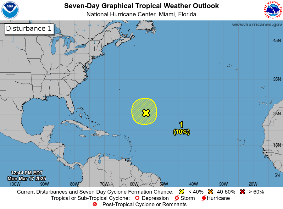
1220 pm EDT March 17: A non-tropical low located about 700 miles northeast of the northern Leeward Islands is producing gale-force winds and a large area of disorganized showers and thunderstorms. Additional development is not expected as it moves into an environment of strong upper-level winds and dry air tonight and Tuesday. https://t.co/Wq6ZtKgfeH
Close Range Tornado on Highway 15 north of Soso,Mississippi buried in the rain earlier. This #tornado ripped down multiple trees and was extremely rainwrapped.
@MyRadarWX@SevereStudios@NWSJacksonMS#mswx
Tornado survivors:
David and Claudia of Taylorville, Mississippi were forced to seek shelter when a strong #tornado made a direct hit to their home. Thankfully no injuries but a ton of rebuilding on the horizon.
@MyRadarWX#mswx
There is a confirmed tornado on the ground and just passed north of Gordo Alabama. Reported say there’s considerable damage… if you’re anywhere in the path that it’s headed, seek shelter immediately!! It’s headed NW at about 55 mph!!
Potential large tornado on the ground southwest of Tuscaloosa Alabama!! You can see a perfect circular shape which could be showing the outline of the tornado itself. Currently its radar indicated but if you are in this area, take shelter immediately!!!