How and when did the Grand Canyon form? Geologists are still debating one of Earth’s most iconic landscapes.
Research published in #Geosphere explores evidence that an ancient proto–Colorado River may have filled a vast basin in northern Arizona before spilling westward—potentially helping establish the modern course of the Colorado River through the Grand Canyon.
This study argues against the spillover hypothesis based on evidence suggesting that the preserved lake deposits represent a shallow, playa-like lake rather than a deep, overflowing lake. Thus, this work supports a more gradual integration of the Colorado River system.
However, new research published in Science and featured in Scientific American presents new evidence that supports both the spillover hypothesis as well as an older more gradual integration of the Colorado River system.
This new study suggests that by around ~6.6 million years ago, an ancestral Colorado River was flowing into the northern Arizona basin, where a large lake (or lake system) likely formed and eventually spilled westward to establish the modern Colorado River pathway through the Grand Canyon.
So, the debate is no longer “Did spillover happen at all?” but rather “How important was spillover relative to older canyon segments and gradual river integration?”
Although further research is needed to answer this question, these studies add important insight into the long-running puzzle of when and how the Grand Canyon was carved.
Read the Geosphere paper: https://t.co/VGCkH72Ygg
#Geology #GrandCanyon
📢UPCOMING DEADLINE📢 #BSSA is soliciting manuscripts for a Special Issue on Quantifying the Long-term Prehistoric Earthquake Record: Advances and Applications
Deadline for Submission: 1 June 2026
https://t.co/swWfWY6rR5
New research published in #Geology reveals that the Wasatch Fault—one of the most significant seismic hazards in the western U.S.—may be intrinsically weaker than previously thought, helping explain how it can generate large earthquakes.
Through friction experiments and microstructural analysis of fault-zone rocks, researchers found that:
• Fault rocks are significantly weaker (μ ≈ 0.34) than surrounding crust (μ ≈ 0.53)
• This weakness is tied to inherited ductile fabrics overprinted by brittle deformation
• The fault can slip at low angles, enabling rupture in ways that challenge traditional fault mechanics
The study also shows that these rocks can both weaken during slip and “heal” between earthquakes, helping explain recurrence intervals of ~1,000–2,000 years.
This research is gaining traction and has been featured in MSN—read the full study: https://t.co/LuEQjFStTc
#Earthquakes #Seismology #NaturalHazards
🌏 Following the 2016 Kumamoto earthquake, the ground kept slipping—up to 40 cm over six years. Iwasa et al. reveal why monitoring afterslip is crucial to safeguard rebuilt infrastructure.
🔗Read now: https://t.co/z4gjoi6qav
@Hello_geography
🧩 The activity history of secondary faults contributes to improving the precision of the main fault's activity history.
🔗 Read more: https://t.co/dyDD7Q5CQJ
@DaisukeIshimura
Looking ahead to IGC 2028 in Calgary, Canada 🇨🇦
From 12–20 August 2028, the global geoscience community will come together under the theme Geosciences for Humanity—and planning is already underway.
Now’s the time to start thinking about your contribution. The session submission portal is open, and you can also explore opportunities to propose workshops and field excursions through the First Circular.
Key Dates:
🗓️ Session Proposals: March 2026–March 2027
🗓️ Abstract Submissions: June 2027–March 2028
🗓️ Online Registration: June 2027–June 2028
For more information, please visit the IGC 2028 website: https://t.co/HRbJy7ZCWm
#IGC2028 #ICG2028Canada #GeosciencesForHumanity
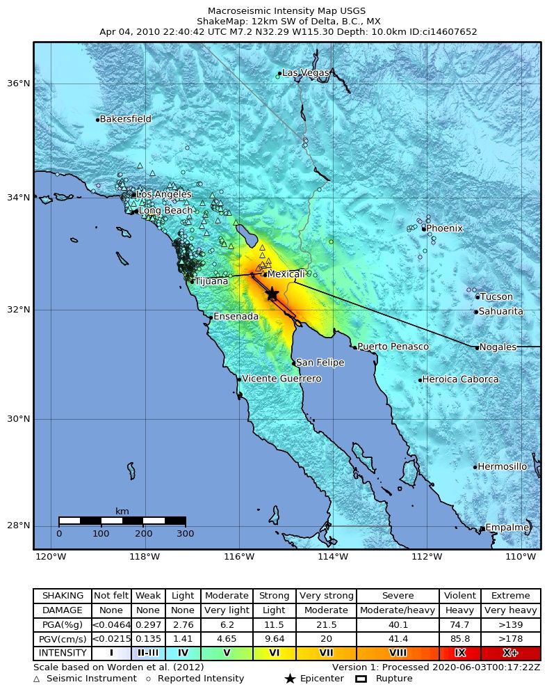
@EQHistory 16 years ago (yesterday) The M7.2 El Mayor-Cucapah earthquake occurred on Easter Sunday. It didn't occur on a single fault though, but across a network of different fault structures near the CA/Baja/Mexico borders.
The rupture extended some 120km producing ground deformation, including liquifaction and road/canal offset near Mexicali.
Thousands of aftershocks followed, which gave scientists one of the clearest looks at how multi-fault ruptures can behave in this region.
It is a great reminder that even if you don't live near a single large fault, complexity can matter greatly when it comes to hazards!
https://t.co/Ja6vW0i07I
🌟OPEN ACCESS🌟 Earthquake Rupture Arrest from Depth‐Dependent Frictional Stability on the Pütürge Segment of the East Anatolian Fault Zone, Türkiye (Turkey) #TSR
What causes an earthquake rupture to cease propagation?
https://t.co/JthE6abut3
Start sharing some great geology photos—landforms, faults, strata—from this week as I process my 2023 field surveys in the #northernTibetanPlateau.
Enjoy.😁
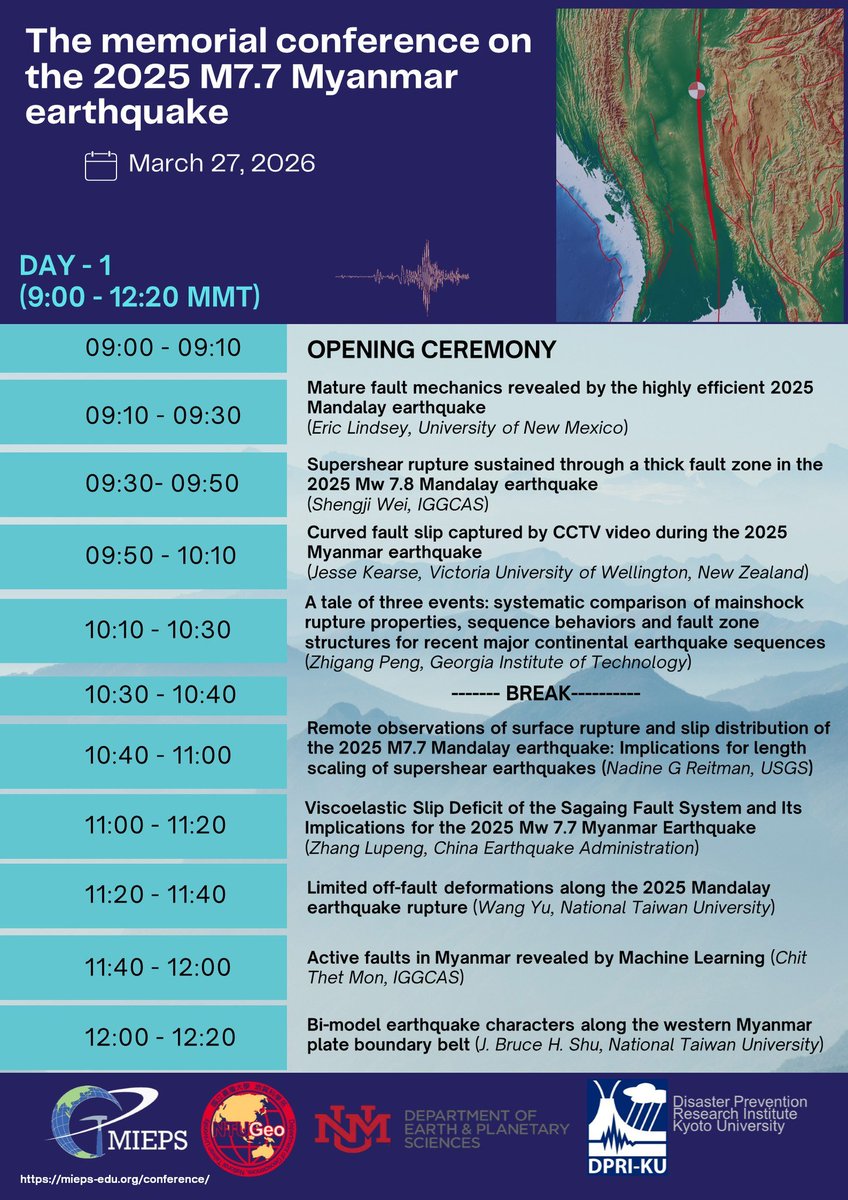
If you are interested in the 2025 Myanmar #Earthquake, here is the online memorial conference we organized covering #seismology, #hazard, and #paleoseismology Feel free to register and attend online! https://t.co/w2cRvA1xHc
It has been almost one year since the Mw 7.7 Mandalay Earthquake. Lessons learned from this event may help us to understand the physics behind large continental strike-slip fault ruptures, & for seismic hazard mitigation. Join us in this memorial conference to learn more about it
✏️ #EditorsChoice
✨ “Examples of Rupture Patterns of the 2023, Mw 7.8 Kahramanmaraş Surface-Faulting #Earthquake, Türkiye”
🎓 by Stefano Pucci, et al.
👉 https://t.co/qSwnKSPHgJ
#coseismic#ruptures