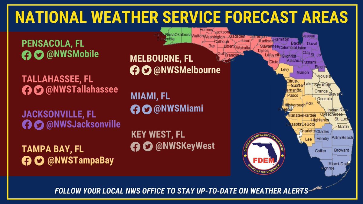
11/17: Heavy rainfall is expected across Florida, bringing a slight to moderate risk of flash flooding along the East Coast through Saturday.
⚠️ Flood Watches:
Brevard, Broward, Indian River, Martin, Miami-Dade, Okeechobee, Orange, Osceola, Palm Beach, Putnam, Seminole, St. Johns, St. Lucie & Volusia counties.
🚨 Flood Warnings:
Remain in effect along the St. Johns River near Astor, Cocoa & Lake Harney. Heavy rainfall & flash flooding this week is likely to cause further river rises.
Find your local @NWS office at https://t.co/0wG5iN2nBO to monitor local forecasts & stay alert!
Your Weatherboy Weathercheck for Tuesday, Nov. 17, 2026 ❄️🌧️🌬️🌎
🏔️❄️ SIERRA NEVADA & LAKE TAHOE: The National Weather Service in Reno calls the system arriving Wednesday "the strongest winter storm of the season." Winter storm warnings run from early Wednesday until 4 a.m. Friday, with 2 to 4 feet of snow above 7,000 feet around Lake Tahoe, 1 to 2 feet at lake level and ridgetop gusts up to 100 mph that will produce whiteouts at times. Travel could be "very difficult to impossible" Wednesday and Thursday, including on Interstate 80 and U.S. 50. Forecasters say Tuesday is your best window for mountain travel, and another storm late Saturday into Sunday could land around the Thanksgiving travel window. Check Caltrans QuickMap and NDOT before you go! 🚙⛓️
🌧️🌊 FLORIDA'S ATLANTIC COAST: Flood watches cover much of the coast from St. Johns and Flagler counties south to Palm Beach County through Friday, with 3 to 6 inches of rain forecast in east-central Florida and localized totals of 8 to 12 inches possible near the coast. The St. Johns River near Cocoa is in major flood at 17.1 feet (6:15 a.m. EST Tuesday), and forecasters say the new rain could push river levels higher. The Weather Prediction Center has much of the east-central coast in a moderate risk (Level 3 of 4) for excessive rainfall Wednesday, and a high surf advisory warns of 5- to 10-foot breakers, beach erosion and life-threatening rip currents. Do not drive through flooded roads! 🚗🚫
🌬️🌊 WESTERN ALASKA: A powerful Bering Sea storm brought gusts near 68 mph to Adak and 62 mph to St. Paul overnight and is set to lash western Alaska Tuesday and Wednesday. A coastal flood warning for the Yukon Delta coast calls for water 4 to 6 feet above normal high tide at Hooper Bay on Wednesday, with 2 to 4 feet elsewhere along the coast. Blizzard and winter storm warnings stretch from the Kuskokwim Delta and Nunivak Island to St. Lawrence Island, where gusts could reach 70 mph, and visibility could drop to a quarter mile or less. Be ready for power outages! 🔦
🌎📈 ALASKA RANGE EARTHQUAKE: A magnitude 3.9 earthquake struck at 4:56 p.m. AKST Monday, Nov. 16 (7:56 p.m. CST), about 32 miles (51 km) south of the community of Denali National Park and about 17 miles west of Denali's summit, according to the USGS. The shallow quake drew two "Did You Feel It?" reports of weak shaking, and a ShakeMap estimated light shaking at most near the epicenter, with no damage expected. The region sits near the Denali Fault, site of a magnitude 7.9 quake in 2002, and has had 33 other magnitude 3+ quakes within 50 km in the past year. Felt it? Report it at the USGS "Did You Feel It?" page.
Dive in deeper in each of these stories at https://t.co/BJBBynHQtD!
#Weather #WinterStorm #SierraSnow #LakeTahoe #California #Nevada #I80 #Florida #SpaceCoast #Brevard #StJohnsRiver #Flooding #RipCurrents #Alaska #BeringSea #HooperBay #Blizzard #CoastalFlooding #Earthquake #Denali #Weatherboy #WeatherboyWeathercheck
Your Weatherboy Weathercheck for Monday, Nov. 16, 2026 🌧️🏔️🌬️
🌧️🌊 FLORIDA SPACE COAST: Two weeks after a historic deluge, more heavy rain is on the way. The St. Johns River near Cocoa stood at 17.05 feet at 6:15 a.m. EST Monday, in major flood and about 5 inches below its 17.5-foot record, and it is forecast to hold near 17 feet through at least Friday. Brevard County crews are still collecting debris from the Nov. 1-2 flooding. The National Weather Service in Melbourne says repeated rounds of onshore showers could bring widespread 2 to 4 inches of rain to east-central Florida from Tuesday through Friday, with isolated totals of 5 to 7 inches or more, and the Weather Prediction Center has the Atlantic coast under a Level 2 of 4 risk for excessive rainfall. Expect numerous, strong life-threatening rip currents, rough pounding surf and breaking waves of 9 to 12 feet Thursday and Friday. Do not drive through flooded roads! 🚗🚫
🏔️❄️ NORTHERN CALIFORNIA & LAKE TAHOE: Winter storm watches take effect Tuesday night into Friday for the northern Sierra Nevada, southern Cascades, Coast Range and Shasta County mountains, with 1 to 2 feet of snow possible above 5,000 feet and up to 3 feet on the highest peaks. The NWS Reno office now expects 2 to 4 feet above 7,000 feet around Lake Tahoe, with ridgetop winds up to 80 mph. Snowfall rates of 1 to 2 inches per hour or more and whiteouts could make travel on Interstate 80 and U.S. 50 "very difficult to impossible," and Reno forecasters advise finishing travel by Tuesday evening. Check road conditions at https://t.co/Y7BBiBe3Pb or call 511. 🚙⛓️
🌬️🌊 WESTERN ALASKA: A powerful Bering Sea storm is forecast to deepen to about 945 to 955 millibars Tuesday night. High wind warnings call for gusts up to 80 mph at Adak and up to 75 mph in the Pribilof Islands, and a winter storm watch warns of possible blizzard conditions on the Kuskokwim Delta coast Tuesday. Coastal flood watches cover Kipnuk and Kwigillingok, hit hard by a destructive storm last year, where water could rise 1 to 3 feet above the highest tide line Wednesday morning, and the Yukon Delta coast around Hooper Bay, where water could reach 3 to 5 feet above normal high tide. Waves of 20 to 30 feet are expected near St. Paul Island through Thursday morning. Secure loose objects and prepare for power outages! 🔦
#Weather #Florida #SpaceCoast #Brevard #StJohnsRiver #Flooding #RipCurrents #California #SierraSnow #LakeTahoe #WinterStorm #I80 #Alaska #BeringSea #HighWind #CoastalFlooding #Weatherboy #WeatherboyWeathercheck
Several feet of snow are possible in California in the coming days, prompting the National Weather Service to issue Winter Storm Watches:
https://t.co/wzb3bH9Q4n
While ULA experienced failure today, SpaceX celebrated success with an incredible capture of Starship at Starbase in Texas. These pictures are unreal!:
https://t.co/to1J6EXOUY
Today's stunning rocket failure isn't just a loss for ULA or their customer, Amazon; it is a loss for the USA which will suffer in its aerospace industry for months if not longer which will have wide impacts to commerce, defense, and the future status of America in space:
https://t.co/3dDTNvdk2s
Weatherboy Weathercheck for Sunday, Nov. 15, 2026 🌊🏔️⛈️🥶🌍
🌊🏔️ CALIFORNIA: Saturday's towering waves flooded streets in Pacifica, damaged the Capitola Wharf railing and pushed debris across Highway 1 near Fort Bragg, according to National Weather Service storm reports. A high surf advisory remains in effect for Pacific beaches from the North Bay to Big Sur until 4 a.m. Tuesday, with another large swell forecast late Sunday through Monday. A winter weather advisory takes effect at 4 p.m. PST Sunday for the northern Sierra and southern Cascades above 6,000 feet, with 2 to 7 inches of snow and up to 16 inches near Lassen Park. A slower, wetter storm arriving late Tuesday could bring 2 to 3 inches of rain to much of the Bay Area and a foot or more of snow to the Sierra. Never turn your back on the ocean! 🚫🏄
⛈️ TEXAS GULF COAST: Radar estimated 1 to 3 inches of rain had fallen near Freeport and Surfside Beach by early Sunday, and forecasters expect 2 to 4 inches on average in coastal counties, with localized flash flooding possible. The Storm Prediction Center has the middle and lower coast under a marginal risk of severe storms, with damaging winds and hail the main threats and waterspouts possible offshore. Gale warnings are in effect for Galveston Bay and Gulf waters, wind advisories cover the coast through Monday, and minor coastal flooding is expected from the Bolivar Peninsula to South Padre Island. Never drive through flooded roads! 🚗🌊
🥶 SOUTHEAST HARD FREEZE: Freeze warnings stretched from central Mississippi across Alabama, Georgia and the Carolinas to southeastern Virginia on Sunday morning. Preliminary readings showed about 27 degrees at Greenville-Spartanburg and 28 at Birmingham, Huntsville, Athens, Macon, Augusta and Columbia, South Carolina. For much of Georgia, it is likely the last freeze warning of the fall, as the weather service office near Atlanta ends its frost and freeze program Nov. 15. Dry, slowly warming weather is expected the rest of the week. Wrap or drain exposed pipes! 🚰🌱
🌍 NORTHERN UTAH QUAKE: A magnitude 3.4 earthquake struck at 6:40 p.m. MST Saturday, Nov. 14 (7:40 p.m. CST), about 7 miles southeast of Huntsville in the mountains east of Ogden, at a depth of about 3.4 miles, the USGS said. By early Sunday, 344 people had submitted "Did You Feel It?" reports, with shaking rated weak from Ogden and Layton to the Salt Lake City area. No damage or aftershocks were reported.
#Weather #California #HighSurf #Pacifica #Capitola #SierraSnow #Texas #GulfCoast #Houston #FlashFlood #GaleWarning #FreezeWarning #HardFreeze #Georgia #Alabama #Carolinas #Earthquake #Utah #Ogden #Weatherboy #WeatherboyWeathercheck
Based on data received by our Launch Director, we confirm that the Vulcan vehicle launched from Space Launch Complex 41 suffered an anomaly 10 minutes into the flight and failed to deliver the Amazon mission to orbit.
Every flight generates data, and every flight teaches us something. Since the anomaly just occurred, we don’t have any specific data yet to understand what occurred today.
ULA exists to provide assured access to space for our nation and for the customers who depend on us. That purpose is why we take on some of the hardest missions in spaceflight, and why we hold ourselves to the standard of mission success. Today, we did not meet that standard.
We will work closely with our customer and other appropriate organizations to find the cause, determine the appropriate corrective action, and return to flight as quickly as possible.
ULA is committed to full transparency with our customers, and they will have visibility into the investigation process, which utilizes rigorous methodology and corrective action.
We will provide further updates when new information becomes available.