Here is the latest NASA M2M model run with TWO CMEs in ensemble mode. This is a unique setup. The M9.5 and X1.0 CMEs are seen here in what looks like a CME combo event, essentially the X1.0 "catches up" with the M9.5. These are notorious for being difficult to model...
Direct Hit! The solar storm launched during the M9.3-flare is indeed Earth-directed! Since this is the second significant eruption from Region 4455 while in the Earth-strike zone, this means this second storm could get "held up" in "traffic" on its way to Earth. The NASA solar storm prediction shows the second storm arrival by late June 4. However, the first storm will precede this so expect some impact starting around mid-day June 4 with the stronger storm arriving close behind!
The strongest and most destructive tornado on that day was the stove pipe near Mingshui, Heilongjiang Province. At least 313 homes were damaged or destroyed, 9 people injured.
#OldPhotoFriday ��� Deshler, OH, F4 #tornado on June 8, 1953. This mighty twister trekked at least 60 miles across northwestern Ohio, killing 8 and injuring 48. Thomas Grazulis in Significant Tornadoes noted that damage near Cygnet may have been of F5 intensity. It was part of a historic 3-day outbreak sequence that stretched from the Central Plains to New England. Photo from Tim Raker and sourced through the Cygnet, Ohio History Facebook page: https://t.co/KH56EJUHQU
Read about more tornado history events on our website at https://t.co/3lVw45jpLI
Today is the anniversary of the El Reno, Ok tornado of May 31, 2013. I narrowly escaped injury from that tornado after being inside the main circulation. Linked here is my detailed account of that day, photos, maps, videos and archived weather data. https://t.co/KQ93ZdWp2x
Gas is rocket science at some of these pumps! It took me three minutes and a discussion with Chris to figure out which gas I was supposed to use.
Thank you for all your continued support keeping us on the road, friends… The link is in my pinned post if you'd love to chip in!
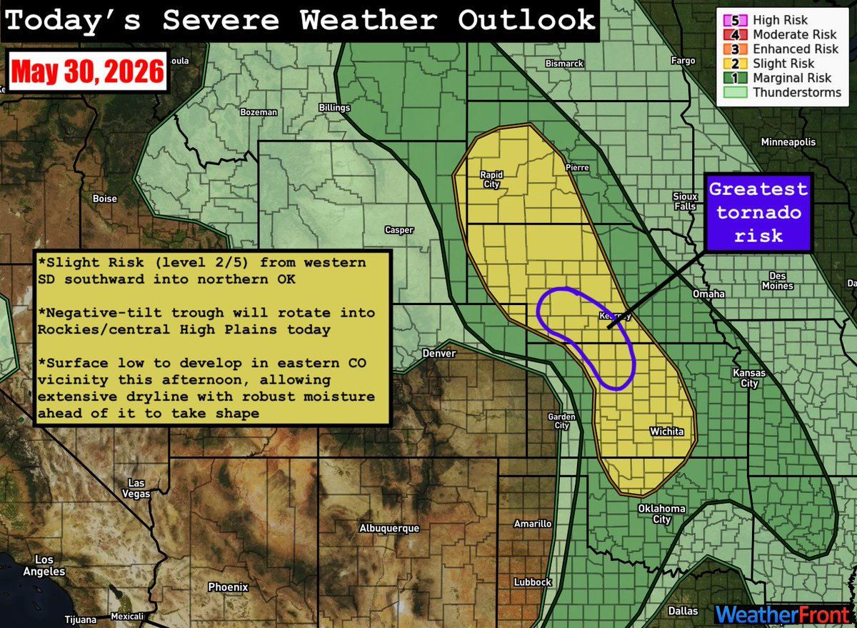
SPC has outlined a large Slight Risk (level 2/5) from western South Dakota southward to northern Oklahoma. A negative-tilt trough will rotate into the Rockies/central High Plains today, providing the forcing for ascent needed for storm initiation along the length of the dryline, but modest flow aloft will keep deep-layer shear marginal for supercells across the entire risk area. Still, there are a few areas of note:
*Northeast CO/southwest NE/northwest KS: Storms may develop within a tongue of robust moisture arcing back into the region, coincident with southeasterly upslope flow. However, this moisture is extremely shallow in the vertical, which may be a challenge for widespread initiation. Should storms sustain, a mix of multicells and a few supercells is expected, posing a risk for all hazards, including a couple tornadoes. Storms may eventually grow upscale into clusters/lines with time.
*Central KS to northern OK: Confidence in storm initiation has increased here in the last day or so; however, the dryline is much more diffuse here, and storms are likely to initiate in the much more meager dewpoints just ahead of it, as opposed to the very moisture-rich airmass farther east (see graphic). This may lead to a mix of multicells and supercells that produce ample outflow and grow upscale into clusters/lines quickly, decreasing the tornado risk and increasing the damaging wind risk. Should any isolated supercells develop or sustain into the better moisture farther east, an all-hazards risk would exist. Questions remain over how this convection may impact the northern risk; should ample convection develop and grow upscale, it may impinge upon the northern regime, allowing for a messier, less potent event there. ***As of the 11:30am update, SPC has added an Enhanced Risk across central KS to cover the significant damaging wind potential.***
*Northwest TX/southwest OK: While a bit more conditional than areas north, a mix of multicells and a couple supercells may develop along the dryline here, as well. The dryline is much less diffuse here, but temperatures will be hot (approaching 100°F), leading to high temperature-dewpoints spreads and a tendency for outflow-dominant convection. Large hail and damaging winds will be the greatest threats here.
Cold air funnel seen from our office! Today is favorable for more of these short-lived weak circulations, due to lots of "spin" in the atmosphere & cold air aloft, leading to robust cumulus updrafts. Usually these don't reach the ground. For more info: https://t.co/TxwdFbSfXG
A new real-time solar wind viewer is now available on our webpage at https://t.co/CxVMJhZprU. The new display makes it much easier to modify timelines, switch between data source (ACE or DSCOVR), and more. The experimental phase of this product lasts to 30 June, 2026.