Lol yikes.
The mean warm pool is incredibly far east at this stage of our El Nino event.
As high as those SSTa are in the East Pacific now, this Super El Nino is honestly just getting started.
Just wait til we advect in those 29-30C SSTs to the east later this year 😬 😳
The lack of morning weather balloons launched across the western and central U.S. is having a real, tangible impact on degrading forecast quality.
We can't look at weather balloon data that doesn't exist. We can't pump nonexistent data into models. We can't rely as heavily on models that don't "know" what's happening above our heads.
Today's severe weather forecast is less certain because we don't have weather balloon data to confirm the strength of jet stream winds aloft.
This is extremely frustrating, and is the result of logistical, organizational, political and budgetary decisions.
Breaking: our new study just published shows that a stable or strengthening ocean current into the Nordic Seas is not a sign of a stable Atlantic overturning #AMOC. On the contrary, it is a physically expected result of an AMOC weakening.
Open access: https://t.co/ssKLF4EYDp
We need help filling out a critical need for rainfall data across portions of the western Carolinas and northeast Georgia. If you or happen to know anybody who lives in the starred counties below, please encourage them to sign up for CoCoRaHS today.
Link: https://t.co/WCdMpwKzOZ
A significant shift in global atmospheric wave patterns is forecast by June as El Niño strengthens and rising air intensifies across the Pacific.
This is when the ocean-atmosphere system is expected to become coupled, signaling the onset of El Niño-like weather patterns.
What a HORRIBLE forecast by meteorologists – especially myself.
Not only were we spectacularly wrong – we communicated poorly.
It became apparent last night that some of our initial expectations would prove fallacious.
I'd like to address what went wrong with our forecast:
@NWS has confirmed an EF-0 tornado occurred in Charlotte today, producing wind speeds of 85 miles per hour, was 1.5 miles long, and measured 25 yards wide.
While today's storm has passed, we encourage everyone to remain prepared for future storms by making a plan, building a kit, and signing up for CharMeck Alerts.
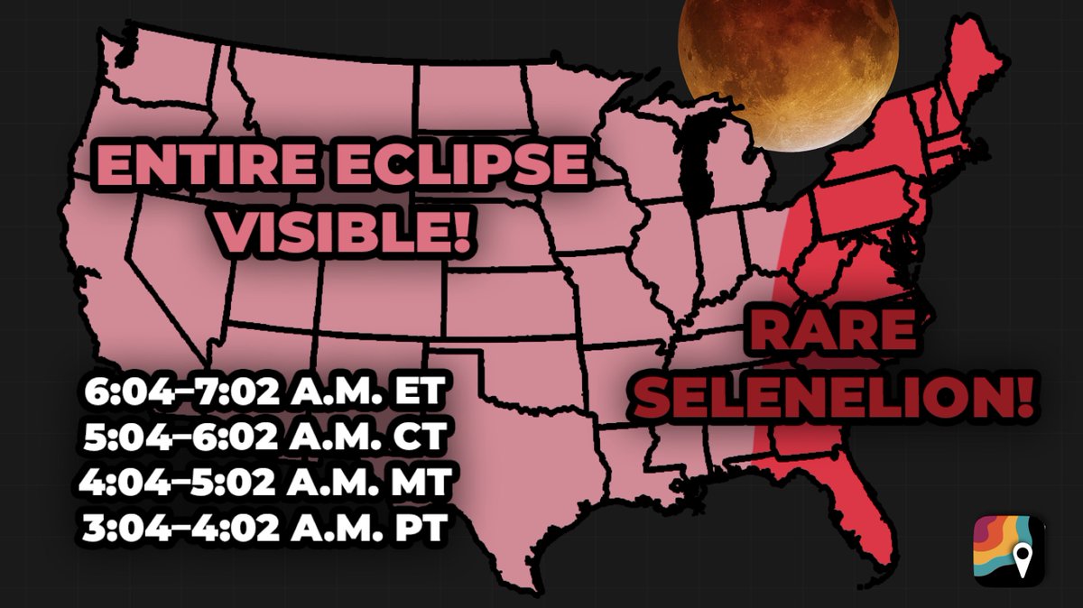
The moon will TURN RED for 58 minutes on Monday night/Tuesday morning. And for the East Coast, this is a RARE SELENELION! Truly magical.
For everyone in the United States, expect to see the moon transform into a brownish-red rust as it slips into the Earth's shadow. Totality lasts 58 minutes.
For the East Coast, that will coincide with sunrise AND moonset! If you're in the dark red, you'll have the rising sun in the east AND the eclipsed moon setting in the rest for a few moments at the time of local sunrise. This view will last a couple minutes – you'll be in a magical, perfect planetary alignment. (Having a clear view of both horizons will be ideal, as is being high up.)
Where temperature profiles cooperate, you might get this rare, ephemeral "impossible" view for a little longer. Why? Earth's atmosphere can refract, or bend light, allowing the moon to be visible for a few extra moments even if it's technically below the horizon.
Share this with your friends and ENJOY! Share your photos too!
DYK: a typical lightning strike has enough energy to cook approximately 1 million slices of toast? We do NOT recommend you do this, nor do we know how you would even try. In fact, let's just forget about this whole thing. Just make sure you head indoors when you hear thunder roar. #NationalToastDay
Cuba 🇨🇺 has just recorded its lowest temperature on record this morning, with 0.0°C (32°F) at Indio Hatuey. This marks the first time in recorded history that the country has officially reached the freezing point.
While North Carolina digs out from the weekend snowstorm, we've been digging into the data.
Our latest blog has a region-by-region review of the totals, including a part of the state that hadn't seen this much snow in 67 (yes, 67!) years. #ncwx
📰: https://t.co/Lv1CbFwH1k
[Tuesday, 1/27 Forecast]
The EPS & AIFS guidance noticeably shifted southeast today, either showing a major Carolinas snowstorm or keeping the heavy snow entirely offshore, while missing the DC-NYC-BOS corridor. The GEFS, in contrast, is far more aggressive with snow expanding closer to I-95.
While current probabilities of a major DC-BOS snowstorm have decreased, I would still not feel confident in locking in on any particular solution just yet.
Forecast analysis below:
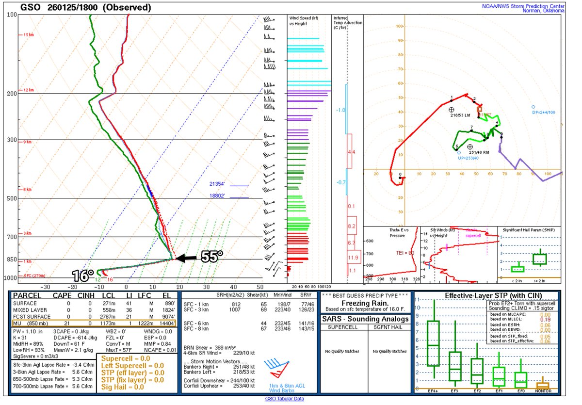
This might be an all-time sounding around here, 55° at 3280', but it's 16° at ground level. Also the 180° shift in the wind within like 200' from northeast to southwest. For laymen, this is the weather balloon at 1 pm from Greensboro, the sounding showing temperature with height. Super CAD here! #cltwx #ncwx #scwx #wcnc
The major winter storm and cold outbreak in the central & eastern U.S. this weekend will be most notable not for record cold, nor heavy snowfall, but instead for very heavy ice accumulations that will cause widespread/severe electrical infrastructure and travel disruptions.
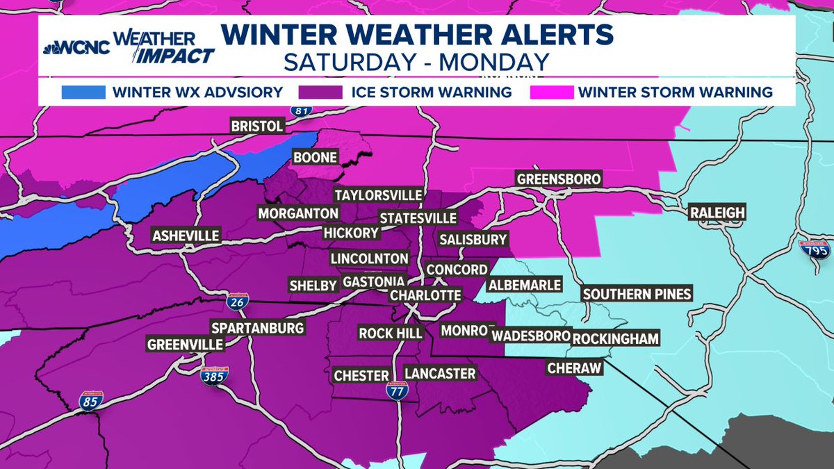
Ice Storm Warning now in effect for our entire forecast area, 1 PM Sat to 1 PM Mon, replacing Winter Storm Watch. Expected impacts haven't changed, but confidence has increased on significant/widespread impact mainly from freezing rain, thus the name change. #ncwx#scwx#gawx
🚨 URGENT WEATHER ALERT: THIS IS THE REAL DEAL 🚨
Folks, I cannot stress this enough: Please prepare now!
We have all day today (Friday) and most of the daylight hours on Saturday to get ready. After that, the window closes. This is not a "bread and milk" situation—this is a major to extreme ice threat. We are looking at a setup we haven't seen in at least 10 years, and if the higher ice totals hold, we could be looking at something we haven't dealt with in 20 years (think back to the 2002 ice storm).
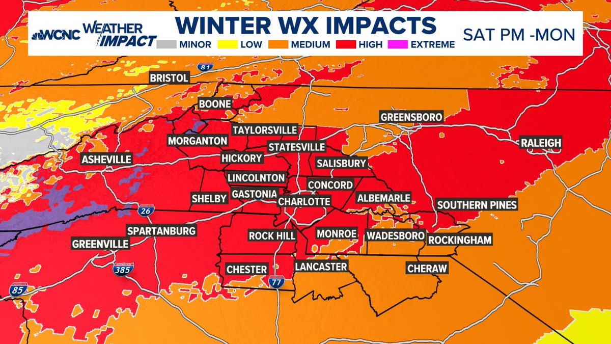
Here is the reality of what is coming this weekend (Sat PM - Monday):
🧊 THE ICE THREAT
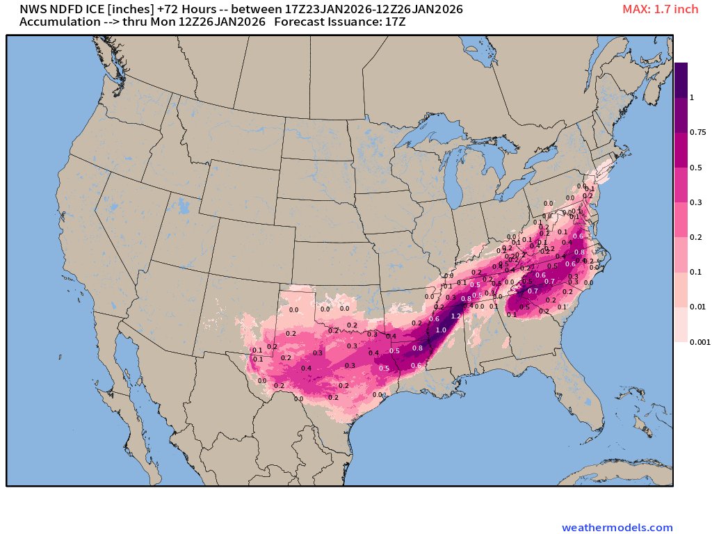
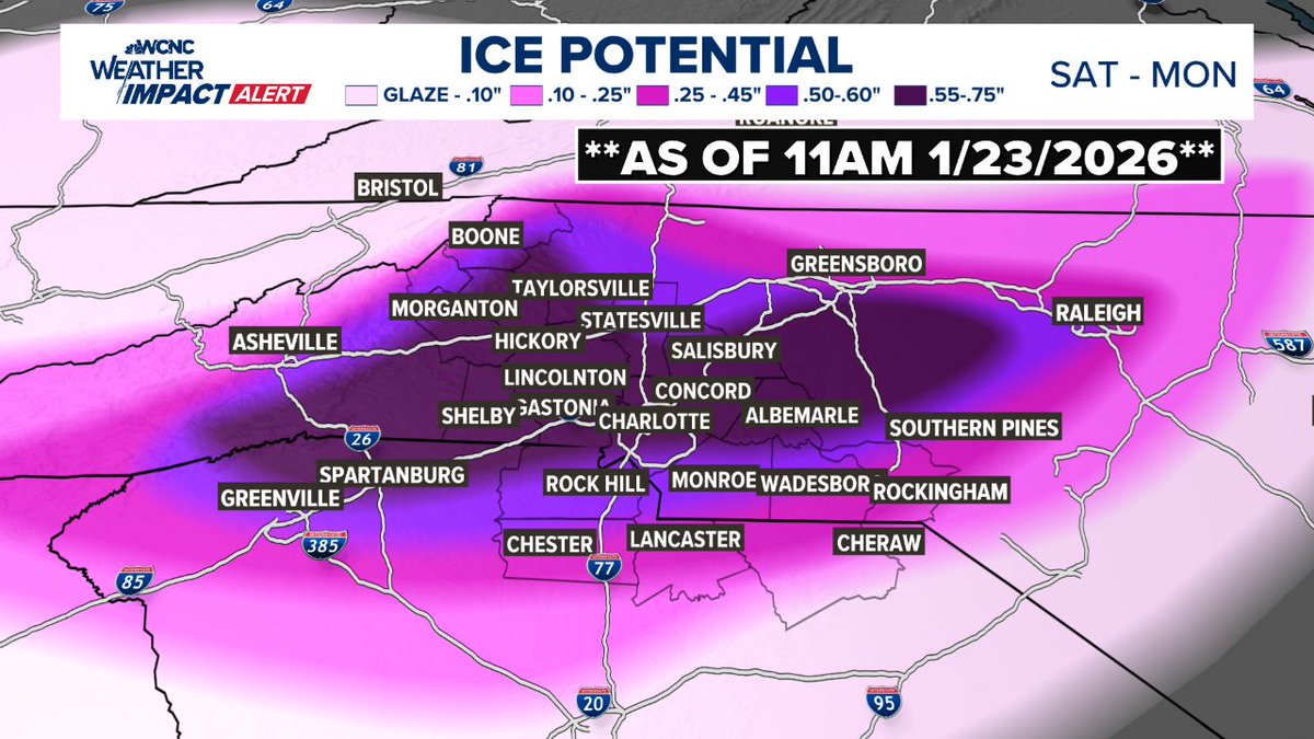
Look at the maps attached. That pink and purple area isn't just "snow." It is freezing rain and heavy ice accumulation.
The forecast shows potential for 0.25" to 0.75" of ice.
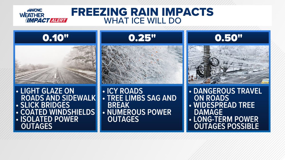
What that means: At 0.25", tree limbs snap and power lines go down. At 0.50"+ (which is possible in the darker purple bands), we are talking about widespread, long-duration power outages and impassable roads.
🛑 IMPACTS: WHAT TO EXPECT
POWER OUTAGES: This is my biggest concern. With ice accumulating on trees and lines, outages are likely. If you are in the high-risk zones, you need to be prepared to be without power for days, not hours.
TRAVEL: By Saturday night, travel will likely become dangerous to impossible. Do not plan to be on the roads Sunday. If you get stuck in an ice storm, emergency crews may not be able to reach you quickly.
TREES: The weight of the ice will bring down weak limbs and trees. If you have large trees over your driveway or home, be hyper-aware.
⏳ YOUR ACTION PLAN (DO THIS NOW):
You have until Saturday evening to get this done. Do not wait.
1. CHARGE EVERYTHING: Phones, laptops, tablets, and power banks. Do it now while the grid is 100%.
2. HEAT: If the power goes out, how will you stay warm? Have blankets ready. If you have a fireplace, get wood. **NEVER** use a generator or grill indoors—carbon monoxide is a silent killer.
3. FOOD/WATER: You don't need to panic buy, but have enough food that doesn't require cooking (sandwiches, dry goods) and water for 72 hours.
4. MEDICAL: If you need prescriptions or oxygen, secure it today.
The Bottom Line:
This isn't a "fun snow day." This is a damaging ice event. We have been lucky for a long time, but the data is showing a setup that demands respect and preparation.
Use today and tomorrow to prepare your family and check on your elderly neighbors, then stay off the roads once this starts.
Stay safe, stay warm, and stay tuned for updates.
#cltwx #ncwx #scwx #wcnc #iceOMG #icestorm #wxbrad
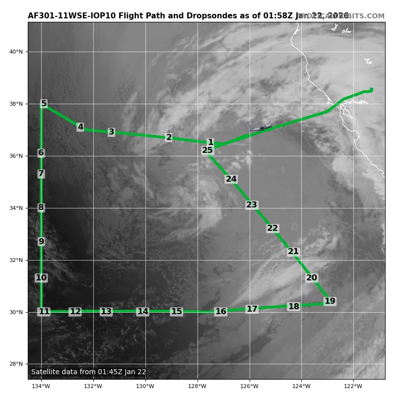
Today's @53rdWRS winter storm mission went as planned, and all 25 sondes will be assimilated for tonight's 00Z runs of the GFS and ECMWF. Bit of caution tho, one round of sondes isn't a magic pill. Helps with initial conditions, but could take a few runs to lock in the pattern…









![burgwx's tweet photo. [Tuesday, 1/27 Forecast]
The EPS & AIFS guidance noticeably shifted southeast today, either showing a major Carolinas snowstorm or keeping the heavy snow entirely offshore, while missing the DC-NYC-BOS corridor. The GEFS, in contrast, is far more aggressive with snow expanding closer to I-95.
While current probabilities of a major DC-BOS snowstorm have decreased, I would still not feel confident in locking in on any particular solution just yet.
Forecast analysis below:](https://pbs.twimg.com/media/G_tbEOjW4AABjdj.jpg)