Excited to share that I’ve joined the @iceyefi solutions team. We have a huge opportunity to bring transformation to the response & recovery landscape—and we are building a team to do just that. Stay tuned friends. #resilience
We are happy to announce Andy Read joining as our Global Head of Government Solutions! Andy will lead ICEYE’s efforts to deliver actionable, #NaturalDisaster data to public sector organizations, helping them understand the extent of damage. https://t.co/Pkxo95M5Qh
We are proud to share that ICEYE has won Earth Observation Program of the Year at the 2026 Australian Space Awards. Read the full press release here: https://t.co/OGITcbp5gl #EarthObservation#FloodResilience#AustralianSpaceAwards
Florida Flood Hub and ICEYE are expanding flood intelligence capabilities with near real-time data, helping emergency managers improve preparedness, response, recovery, and resilience before and after major storms. @USFCMS https://t.co/GZ3GF5uQv3
Launch success! Communication established with 2 newly launched ICEYE satellites expanding sovereign missions for Poland and Portugal.
This marks our third launch of 2026, as we continue scaling the deployment of sovereign space capabilities at unprecedented speed and scale.
Protecting forests begins with clearly seeing what’s changing on the ground. ICEYE has partnered with @JaneGoodallInst to deploy its SAR-based #Deforestation Solution across the Congo Basin, delivering intelligence that cuts through cloud cover and canopy: https://t.co/LWDqQL5uHv
Separation confirmed.
All six ICEYE satellites have successfully separated from the Falcon 9 rocket.
The satellites will now begin early orbit operations.
Video: @SpaceX
🇫🇮Finnish satellite company Iceye revenue:
2024 $120m
2025 $250m
2027 target published today: $1,2 billion (Rheinmetall jv starting etc)
Closest public market peer $PL 🇺🇸 Planet:
2024 $220m
2025 $244m
2026 (est) $297m
2027 (est) $377m
Iceye is profitable, with positive cash flows. PL is heavily unprofitable.
Both sell satellite constellations / image data that are long term strategic assets for governments and companies.
PL faces more competition (more competition in optical sats than SAR sats) and Iceye is heavily skewed on "looser" and more stable government / defence contracts, which I'd guess is the main reason for the profitability difference.
Iceye latest round valued at $2,8b = 2,3 x 2027 target
Planet current valuation $8,5b = 23 x 2027 est
Sure PL likely overvalued currently. But still, thats a 10 x difference. And private markets do like to use public market peers as measuring stick (ofc only in case of discount).
Iceye starting to look cheap if the 2027 target is even at ball bark level. And not just by comparing to PL.
Iceye managed to achieve profitability in this high growth phase of 2025, so could assume at least pretty good economics/margins long term (tho we don't know yet exacts).
$SSIT 🇬🇧 Seraphim holds 39% of NAV in Iceye (and trading currently pretty much exactly at NAV).
SSIT did raise their NAV calculation of Iceye +34% in latest February release "using public‑market comparables", which already factors in some of that discount.
Deforestation is complex. Acting on it shouldn’t be.
Our new #Deforestation Solution 2-pager outlines how agencies and nonprofits can detect forest loss through clouds and smoke.
Download it now in English, Spanish or Portuguese. https://t.co/Bzw2HRZhV3
ICEYE launches cloud-penetrating SAR #deforestation monitoring, delivering near real-time intelligence to law enforcement, NGOs, and climate regulators to stop illegal forest clearing.
https://t.co/hiW71jjOR9
Gen4 delivers a major boost in high-performance field of regard and revisit using 1200 MHz imaging. The example below illustrates the increase in field of regard from 150 km to 400 km with Dwell Precise imaging mode.
Learn more at https://t.co/jBeO6aY8s6
All five satellites have established communication following SpaceX’s Transporter-15 launch.
They’ll support ICEYE's commercial constellation and national missions for Greece, Poland, and BAE Systems’ Azalea program.
Read more: https://t.co/UgrX018dIt
Video: SpaceX
ICEYE's Gen4 is now commercially available, setting a new performance standard with up to 16 cm resolution and an expanded 400 km field of regard – resulting in the world's highest-fidelity SAR imagery.
Read more here: https://t.co/VOI79P9aLp
Former FEMA Administrator & President of @BrightHarborCo Pete Gaynor, and ICEYE VP of Government Solutions, @AndyRead22 share how smarter, faster tools can provide better situational awareness, protecting lives and municipal resources in @TheHill: https://t.co/aykhzq6Va5
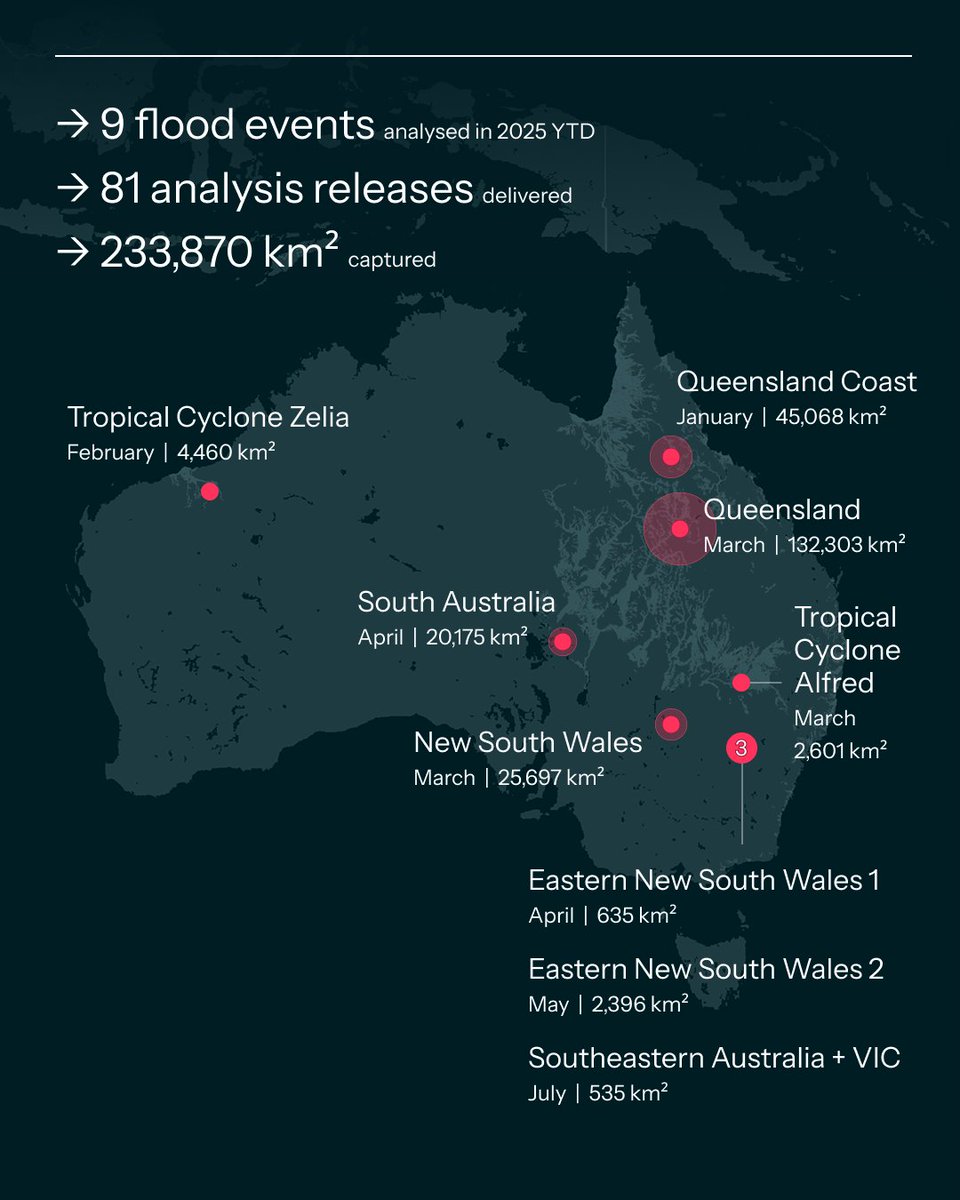
🌧️ 2025 has been a relentless year for flooding across #Australia — from the Queensland Coast flooding in January, Tropical Cyclone Alfred in March, and more, to the most recent inundation in Southeastern Australia in July.
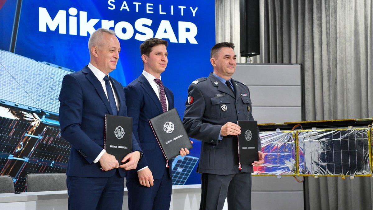
ICEYE signed an agreement with @MON_GOV_PL to deliver the Polish Armed Forces with 3 ICEYE SAR satellites, and an option to purchase 3 more in the next 12 months, under the Polish Armed Forces’ #MikroSAR program.
Read more: https://t.co/j6npQ0TwVP.
What if you could get building-level flood extent and depth data, without tasking satellites or decoding SAR imagery?
For this #HurricaneSeason and beyond, benefit from ICEYE’s flood insights, delivered within hours, so you can act with confidence.
https://t.co/KezK25Dj9N
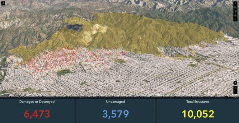
“With the fires in Los Angeles, there was a massive data gap. Agencies couldn’t fly because of the persistent high winds and couldn’t see through the smoke or as the fires burned during the night," said @AndyRead22.
Read more: https://t.co/RRXLZHLktO
This week, we attended the Northern Lights geospatial event at the Finnish Embassy in Washington, D.C. We heard thought-provoking presentations from Finnish geospatial and space companies, and @AndyRead22 presented how ICEYE is transforming disaster response.
We delivered 2 flood extent and depth reports for Poland, utilizing imagery from ICEYE's SAR satellite fleet and auxiliary data. Our team continues to closely track the evolving situation in Austria, where we expect to release our initial flood analysis within the next 24 hours.