ECMWF insiste na projeção de muita chuva sobre o Rio Grande do Sul na próxima semana.
Muito preocupante, porque muitas áreas poderiam receber mais de 150mm em apenas 24h.
Caso se mantenha, é altíssimo o risco de enchentes, deslizamentos.
GFS não indica todo esse volume.
El Niño will help power an impressive extension of the subtropical jet stream across the Southern Hemisphere over the next week.
Powerful storms are expected to hit parts of Chile, including Santiago, while unusual cold spreads across the South Pacific islands.
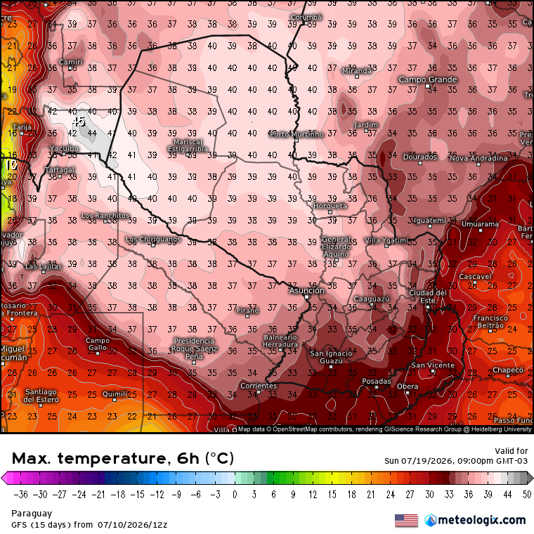
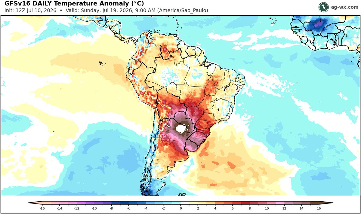
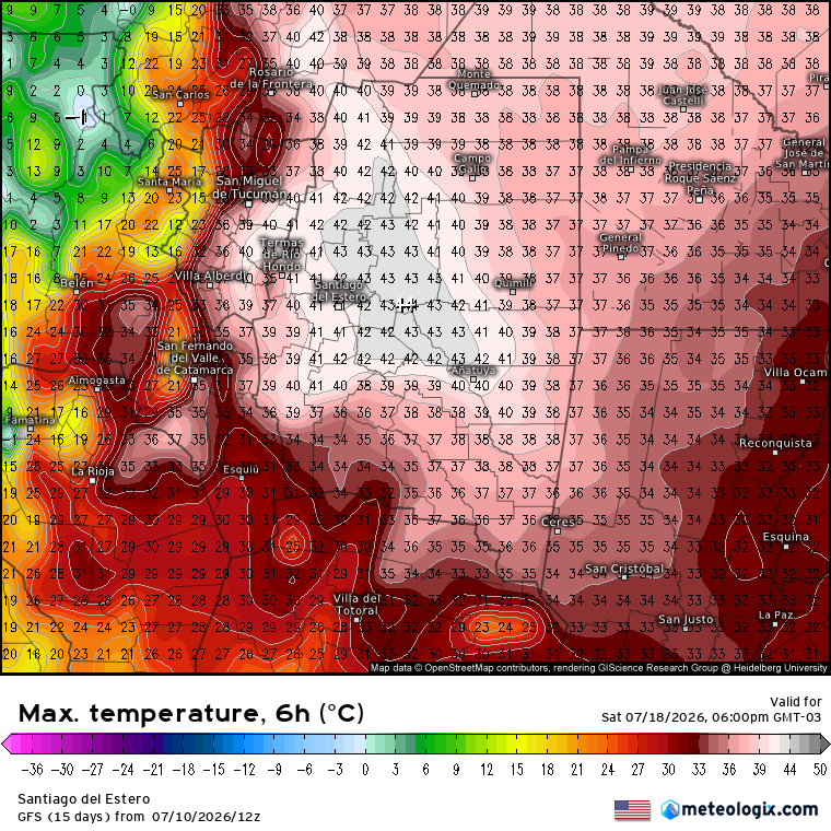
O GFS continua insano. Anomalia de temperatura com valores fora da escala, superando mais de 16°C acima da média nos dias 18 e 19.
Nestas áreas, o modelo projeta temperaturas de até 45°C.
Just released: An El Niño tracker for the world!
See how strong El Niño is getting, intensity forecasts and maps that show the risk of extreme climate conditions in the months ahead — all updated regularly.
🔖 Bookmark this one! https://t.co/Dq1NixIkQ4
Here's what's inside 🧵
🌡️ Western Europe recorded its warmest June on record in 2026.
📈 According to the latest #CopernicusEU Climate Change Service bulletin, temperatures peaked at +9°C above avg across parts of 🇫🇷 and 🇩🇪 during the late-June heatwave.
🔗 https://t.co/tW12y1cXDg
#ImageOfTheDay
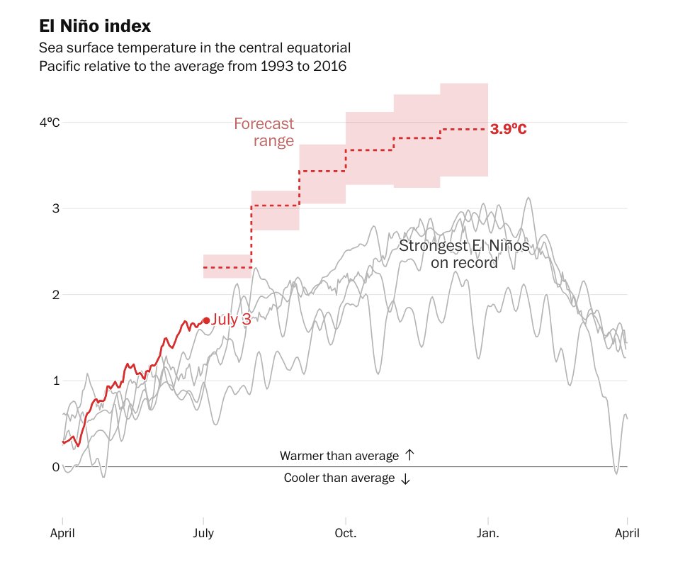
Ya no son previsiones, modelos, teorías... es la realidad.
Vamos a vivir un El Niño como no se ha visto otro en la historia medida.
Lo increíble que es esta gráfica solo se ve superado por lo increíble que es que prácticamente ningún "medio de comunicación" la sacará.
Cenário preocupante, c/ todos os ingredientes pra tempo severo nos próximos dias, muito bem descrito pelo colega! Temporais são previstos entre SC e PR sex e sáb, e domingo pega SP e MS. Acompanhemos!
(Alô seguimores cariocas, NÃO deve pegar sul do estado e região da capital!!)
i'm obsessed with what's happening in AI reforestation right now
this Franco-Brazilian startup called MORFO took a patch of land in Brazil that was rock-hard and compacted from years of cattle farming. they replanted it using a single drone. months later the ground was covered in grass, bushes, and small trees. the land came back to life.
here's how the whole thing works.
1. drones scan the terrain with high-resolution cameras and sensors
2. AI analyzes the imagery alongside soil samples, moisture levels, slope, and surrounding vegetation
3. the system picks from a catalog of 300+ native species, deciding exactly which plants will thrive in which specific spot
4. the drone fires biodegradable seed pods packed with seeds, nutrients, and moisture at 180 capsules per minute
5. satellite and drone imagery monitors regrowth over time, with AI tracking vegetation cover and biodiversity
6. two people and one drone cover 50 hectares a day. a person planting by hand manages about one hectare.
and MORFO isn't alone. AirSeed in Australia drops 250,000 seed pods per day into bushfire-scarred koala habitat, replanting swamp mahogany that koalas depend on to survive. Flash Forest in Canada fires 50,000 pods daily into wildfire-destroyed boreal forest, planning the replanting alongside Cree Indigenous communities. re-green won Prince William's Earthshot Prize after planting 6 million seedlings across 30,000 hectares of Amazon and Atlantic Forest.
five companies across four continents built this same approach independently. nobody coordinated. the physics of the problem demanded it.
knowing which seeds belong in which soil used to require years of ecological fieldwork, manual planting crews, and budgets that made large-scale restoration nearly impossible. now two people with a drone and an AI model trained on local soil data can replant 50 hectares before lunch.
this is the AI work that'll still matter in 50 years.
Há uns anos colaborei em um estudo do @GrecUsp sobre evento de chuva intensa no Sudeste em 06/2016. Agora, 06/2026, modelos indicam novo episódio de mta chuva, c/ padrões atmosféricos surpreendentemente semelhantes. Fascinante comparar os casos! Artigo: https://t.co/mH6V8O6NAf
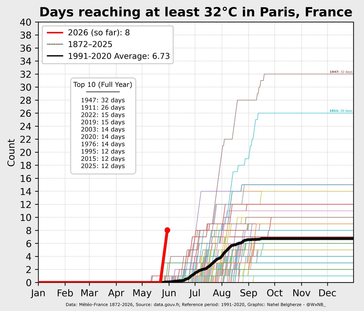
Hard to believe I’m even writing this.
Meteorological summer hasn’t even begun, yet Paris, France has already logged more days above 32°C (89.6°F) than its annual average.
📢Out now: C3S Atlas viewer version 2.5! Explore past and future climate change with simpler navigation, a new time-period selector, side-by-side map comparison & new extreme climatology products. A corresponding dataset will be available soon in the Climate Data Store (CDS).
⬇️
I'm excited to introduce GeoLibre, a lightweight, cloud-native desktop GIS built with MapLibre GL JS and Tauri.
GeoLibre is designed for modern geospatial workflows, combining the flexibility of web technologies with the performance of a native desktop application. The current prototype includes a MapLibre-powered map workspace, local vector data import, project persistence, and built-in plugins for basemaps, layer control, swipe, street view, lidar, GeoAgent, and GeoEditor integrations.
GeoLibre can run directly in a web browser or as a standalone cross-platform desktop application (<30 MB).
GitHub: https://t.co/VXq8c1o2Nd
Website: https://t.co/7VA2AQoCUc
Live demo: https://t.co/Cq5Mg3ojNQ
Feedback, ideas, and contributions are welcome.
#GeoLibre #GIS #Geospatial #MapLibre #OpenSource #CloudNative
Herramienta fascinante para explorar el clima del pasado: Weather Replay, la nueva app de @CopernicusECMWF, permite reconstruir las condiciones meteorológicas de cualquier lugar del mundo hora a hora desde 1940 hasta hoy.
(Ver hilo)
Portal aqui: https://t.co/d2858leiB7
Lançado agorinha, boletim mensal NOAA: El Niño deve se consolidar em breve, e durar até fev/27. Probabilidade de evento forte a muito forte!
COMENTÁRIO MUITO PERTINENTE ALI NO CANTINHO INFERIOR DIREITO: "eventos +fortes não ne-ces-sa-ria-men-te implicam em maiores impactos"
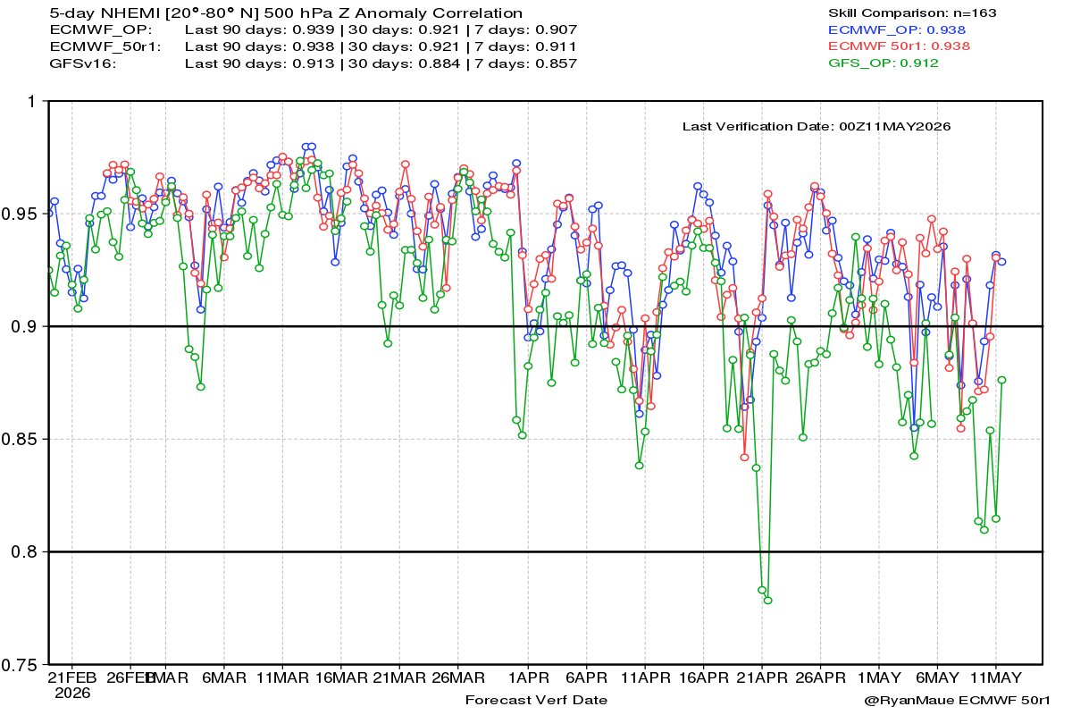
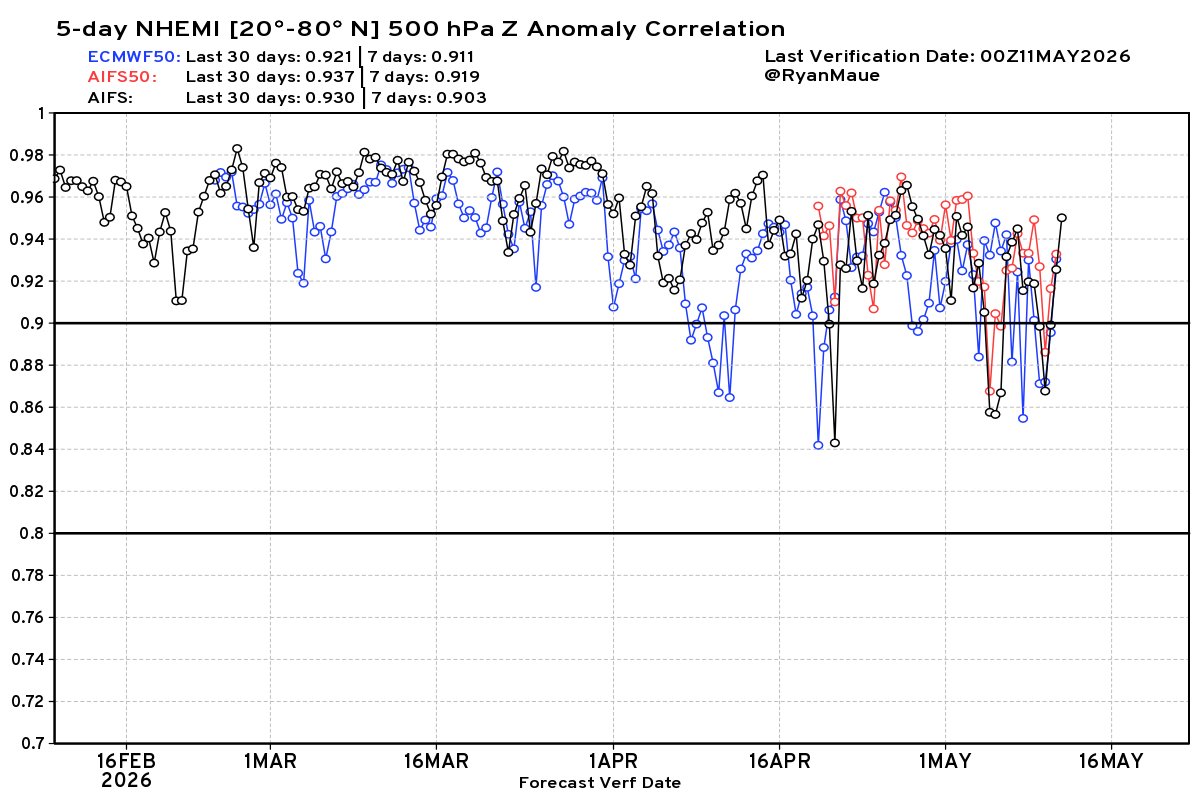
Tomorrow is ECMWF model upgrade day -- and holy moly it's going to be lit. 🥳
New version of IFS + EPS ensembles (full physics) --> 50r1 and AIFS-Ensemble v2 and AIF-Single v2 + ocean waves.
📈Skill scores --> huge blow out increases.
Sets stage for accelerated gains.
The notorious super El Niño of 1877-78 contributed to a global famine that wiped out 3 to 4 percent of the global population.
It was arguably the worst environmental disaster to ever befall humanity.
Are we better prepared now? The evidence says yes 🧵
I am excited to introduce OpenGeoAgent, a powerful open-source multimodal AI agent for automated geospatial analysis and visualization!
It supports QGIS, Jupyter notebook, and Python scripting. In this tutorial, you’ll learn how to automate GIS workflows using natural language, generate maps, analyze satellite data, and even run complex hydrological models.
You can even interact with the agent using voice commands (no typing needed).
Video: https://t.co/mJ0ort5dzb
GitHub: https://t.co/WgiWV1wGMS
QGIS Plugin: https://t.co/qNRP3WPJWe
#geospatial #GeoAgent #OpenSource #AI
When predicting extreme weather, new research finds that a state-of-the-art physics forecasting system still outperforms #AI models. https://t.co/N5KfF1CRJe