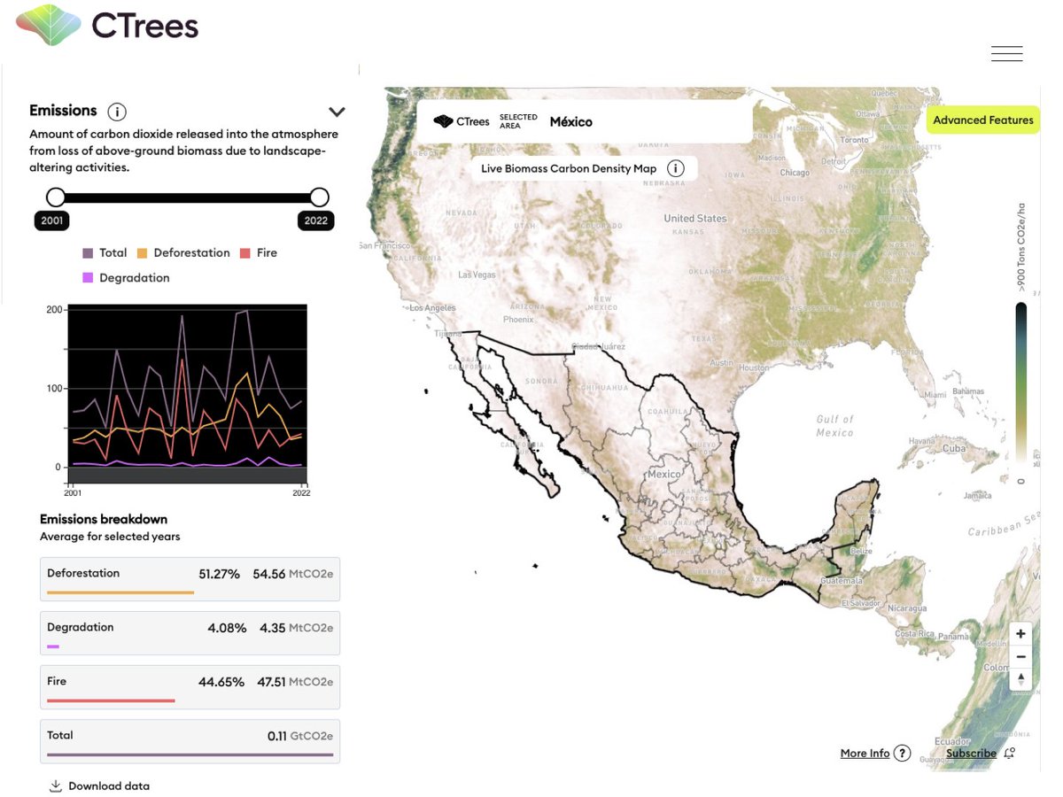
RELEASE: CTrees has updated its country carbon inventory data ahead of #COP28.
The data explorer includes stats on carbon stocks, emissions, removals, and area of forest from 2001-2022 for 185 countries.
Tool: https://t.co/6VxerxHFq0
Release: https://t.co/CwU89Uyimz
Sasaan Saatchi of Climate TRACE coalition member @CTrees_org recently wrote about the monumental difference this satellite will make for monitoring #carbon in tropical forests. https://t.co/VXOv3uaDiM
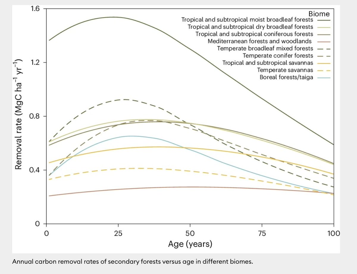
NEW research published in @NatureClimate found that secondary forests with between 20-40 years of regrowth have up to 8x the carbon removal potential of new and mature forests per hectare. @CTrees_org https://t.co/82Ukd1uton
🌿3-yr time-lapse of one of the Mother of Mothers trees of the Amazon rainforest 🌳🍃 likely one of the largest trees in the Amazon, with an astonishing crown diameter > 60 m and height > 50 m ! made with @NICFISatData 🛰️images. @CTrees_org#AmazonForest#TreeGiant#NatureWonder
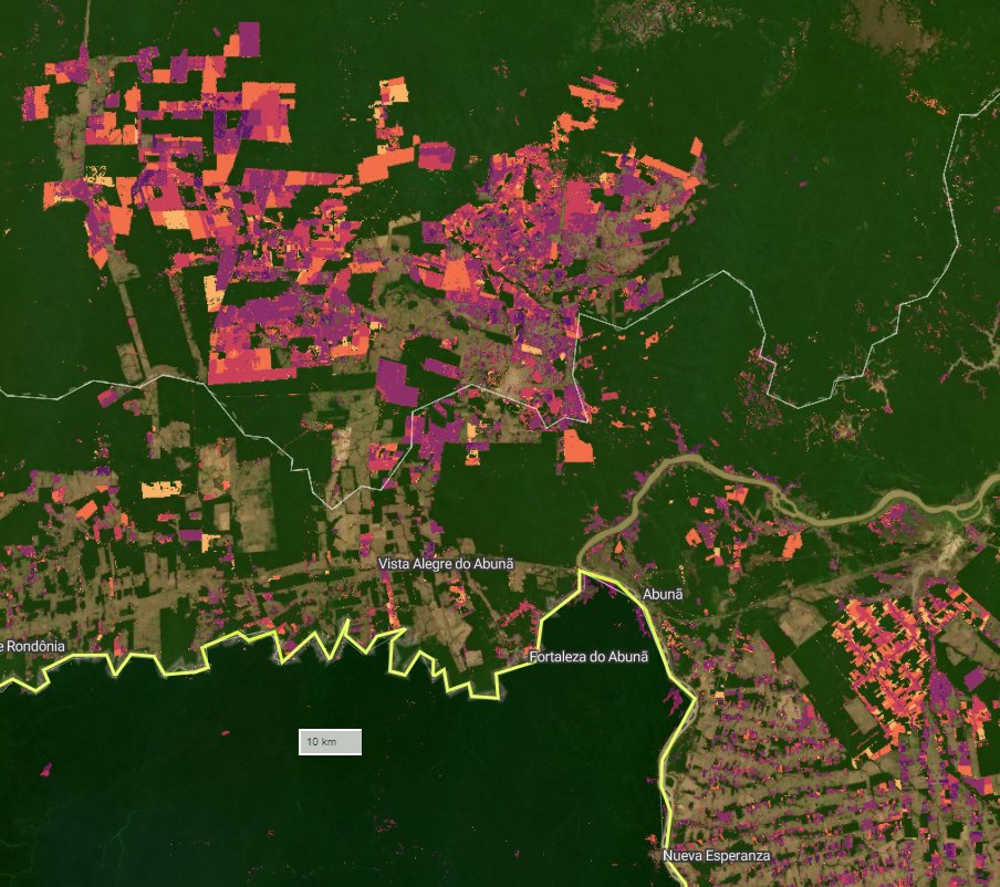
A new tool from Climate TRACE coalition members @CTrees_org allows you to track tropical forest degradation from roads, fires, and more tree cover loss using #satellite imagery and AI.
Check out REDD+AI:
Check out our new REDD+AI platform https://t.co/GdceocxPxS that shows tropical forest degradation—from logging, fire, and roads—and tree cover loss in evergreen forests with unprecedented detail. This is v1, so be kind :) v2 coming soon
@CTrees_org@RicardoDalagnol@NICFISatData
📢🛰️🌳Forest degradation & tree cover loss in the tropics can now be seen w/ high resolution & attributions based on #ArtificialIntelligence and Planet @NICFISatData 5m satellite data
🪵🔥🛣️Available for viz at REDD+AI platform: https://t.co/bjErBgt8Ps
@CTrees_org@FabienWagner
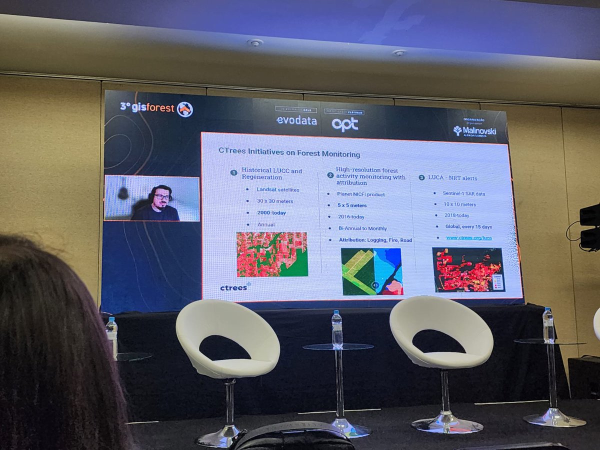
Today I gave an online talk at #GISFOREST event in Brazil on my research & @CTrees_org forest monitoring systems that track selective #logging & #roads#CTrees technology & data help monitor forest management & illegal activities to enhance conservation & sustainable development
Just discovered the most massive tree I've ever seen in the Amazon rainforest via satellite image—over 50 meters in crown diameter and more than 50 meters in height! 🛰🌳@CTrees_org@RicardoDalagnol
Visited INPE this week and presented some updates on the research I lead at @CTrees_org. Top level discussions on forest degradation and applied AI for earth observation. Thanks @aragao_luiz@TREES_Research@dsrinpe for the invite ! :)
In 2020, 4 billion tons of live #carbon were stored in Gabon’s forests, according to new research from @CTrees_org.
Learn more about their findings from measuring the live carbon density of every hectare of forest in Gabon.
https://t.co/tKpdt9vPcM
📢🛰️New paper from Le Bien brings the most accurate #Carbon map of #Gabon to date based on #GEDI & #MachineLearning, verified using #ALS & National Plot Inventory, and shows its variability in the landscape and in forest management
https://t.co/56qwpAaBoU
@UCLAIoES@CTrees_org
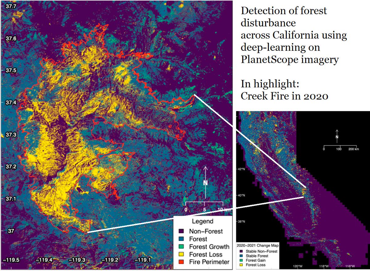
RESEARCH: CTrees' @gc_sci worked with @FabienWagner and @RicardoDalagnol, postdoctoral researchers at @UCLAIoES and research scientists at CTrees, on innovative approaches to map tree cover in California. Study now published in Frontiers in Remote Sensing ⤵️
🌲Our new paper maps state-wide tree cover and forest change using high resolution remote sensing data and a deep ConvNet🧠
"Detection of forest disturbance across California using deep-learning on PlanetScope imagery"
https://t.co/a206e0UNti
📢🌲Sharing our new paper led by Griffin Carter @gc_sci : "Detection of forest disturbance across California using deep-learning on PlanetScope imagery"
🔍Creek Fire in 2020 w/ CALFIRE map (red) and our 3x3 m detection (yellow)
📎 https://t.co/3HfURdukEA
@UCLAIoES@CTrees_org
We mapped a half billion individual farmland trees in India, and tracked their fate over a decade. Many large trees have disappeared. The paper in Nature Sus.: https://t.co/GcDVfuKtKA, Viewer: https://t.co/rdY5tQB5BF. It's a new framework for temporal monitoring of single trees..
NEWS: @CTrees is pleased to announce the appointment of Stephen Hagen, Ph.D., as its first chief operating officer. As COO, Hagen will manage CTrees’ data and research initiatives for monitoring, reporting, and verification of natural climate solutions
https://t.co/2ELozJ4SWE
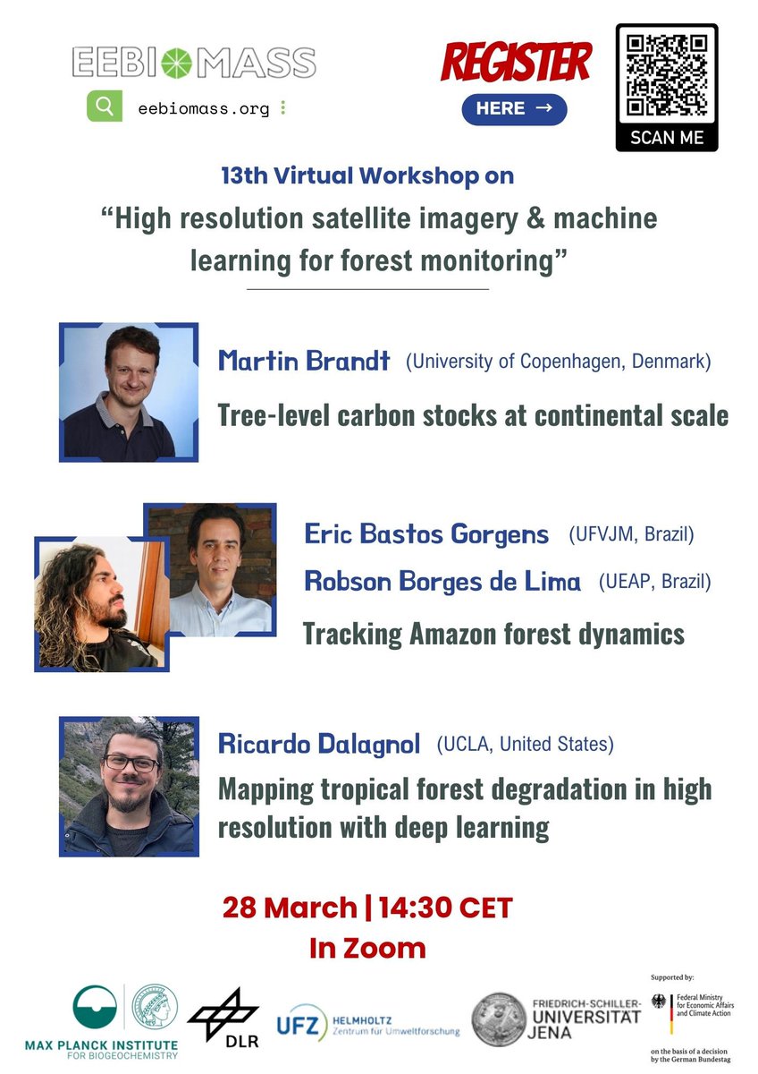
CTrees research scientist @RicardoDalagnol will speak at a workshop on hi-res satellite imagery and machine learning for forest monitoring TOMORROW, March 28 at 14:30 CET -->
Join us for a panel discussion at @SFClimateWeek to discuss the importance of protecting our endangered forests, the positive impact seen to date, and how we can collectively rebuild confidence in forestry carbon credits! https://t.co/GSJeUOveli #sfclimateweek
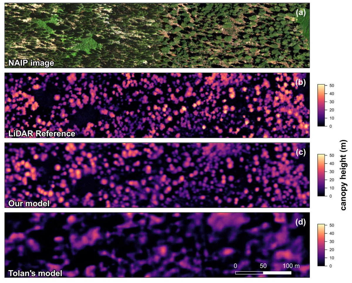
📢🌳New paper led by @FabienWagner in RSE on tree's height mapping over California with #DeepLearning
I really like Fig 7 : it clearly shows how the model predicts height based on optical imagery very close to LiDAR even on STEEP terrain - crazy! 😮
https://t.co/QqGSBAl2mP