🌍Do think sustainability is only an Earth problem?
🚀Under the topic ‘Industrialization and Sustainability in Space’, #SSSIF2025 will discuss how #smallsatellites can be an example of responsible industrialization and address the big challenge of #sustainability
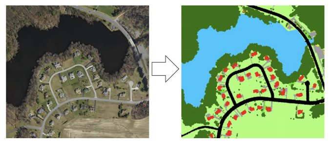
One of the most important models in geospatial data science?
U-Nets.
It's used for:
• segmentation
• super-resolution
• diffusion models
Here's the breakdown (in simple terms):
✈️ Co apoio da @Xunta, @telespazio está a contribuír ao desenvolvemento sostido da industria aeroespacial en Galicia.
Traballa en tecnoloxías dron que terán un papel protagonista para a observación da #biodiversidade.
↘️ Javier Pancorbo é director de Programas de Innovación.
One question I always get is why the "Intelligence" category in our Earth observation value chain is divided into three different segments - Analytics, Insights and Applications.
The answer to that lies in the complexity of the go-to-market strategies and the different perceived value of EO across the user verticals. Let me explain👇
🚨ANNOUNCEMENT! 🚨
We have a new Greenhouse Gas Monitoring & Services webpage!
This new resource offers a one-stop platform for @NOAA-wide GHG information, news, emissions, data, tools, science explainers, reports, assessments, & educational resources.
https://t.co/BJDQTa4Ij7
The Earth Copilot, a collaboration between @Microsoft and @NASAEarth, is a tool for searching, discovering, and analyzing satellite imagery. This looks pretty incredible despite being only a proof-of-concept.
An excellent effort in the path towards making EO mainstream, while AI does the job in the background!
Deimos is now officially part of the @IndraCompany family! 🚀
This new chapter opens up promising opportunities for our team and partners, expanding our contributions in space and technology🛰
Our sincere gratitude to @GrupoElecnor for 23 years of invaluable support⭐
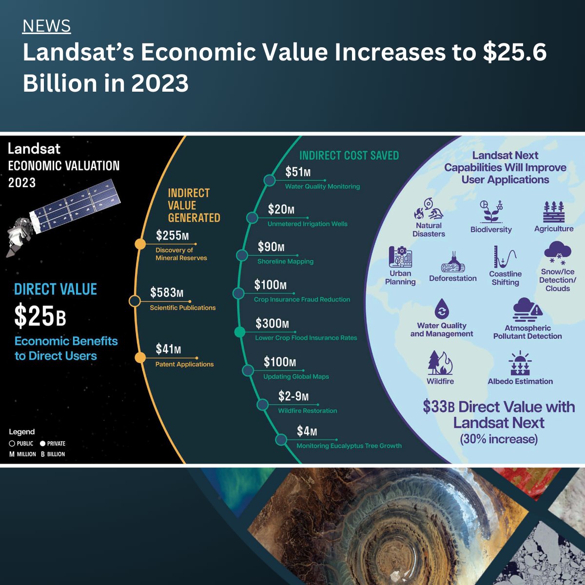
A new report about the #Landsat program—a partnership between the @USGS and @NASA—calculates its 2023 value at $25.6 billion, a marked increase from its 2017 estimate of $3.45 billion. Read more here: https://t.co/7JqE6PCDnF
#LandsatNext#SocietalBenefits
ESA is currently undergoing a transformation to make both the agency and the European space sector more agile and more prepared for future challenges. This is a significant and challenging task. However, @ESA_Hera – a satellite weighing over 1 tonne, equipped with 12 instruments and 2 cubesats, set to encounter a 150-meter asteroid over 190 million kilometers from Earth – exemplifies how @esa's transformation can succeed. #HeraMission was developed on quality, on time, and on cost (actually below cost!). A huge thank you to my ESA project team, to industry partner @OHB_SE, to our ESA Member States, and to our international partners @NASA and @JAXA_en.
There has been so much interest and investment in launching new EO satellites in the past 3-5 years. But, there has been relatively limited interest and investment into solving the boring problems of standardization, interoperability and analysis-ready data* in EO.
🎇 ¡Una nueva gama de lanzadores está por venir!
MIURA Next, Next Heavy y Next Super Heavy tendrán la capacidad de colocar más de 53 toneladas en órbita… y no solo eso, ¡podrá aterrizar!
➡️ Sigue la transmisión en vivo a través de YouTube: https://t.co/F1eXM4GnFo
#beyondbyPLD
⏳Cuenta atrás para Beyond_ by PLD Space: ¡Solo faltan 3 días!
Quedan 3 días para nuestro evento anual más esperado: Beyond_, que se celebra en el primer aniversario del lanzamiento exitoso de MIURA 1, coincidiendo con la Semana Mundial del Espacio.
🗓️No te pierdas la presentación de #BeyondbyPLD el próximo lunes 7 de octubre a partir de las 12:30pm CEST.
➡️ El evento se retransmitirá en streaming en directo a través de nuestra cuenta de YouTube Live. Podrás verlo aquí:
▪️ Versión en inglés: https://t.co/O1M2totazX
▪️ Versión en español: https://t.co/i9HRKQWDlZ
¡Prepárate para disfrutar de la experiencia!
📢New paper out
▶️Chlorophyll-a and suspended matter variability in a data-scarce coastal-estuarine ecosystem
ℹ️https://t.co/WPohf1o1rn
@univcadiz@Quasar_SR@ICMAN_CSIC@teledetect
Yesterday, the European Commission proposed to postpone the implementation of the deforestation regulation (EUDR) by one year until the end of 2025. While the reasons and environmental consequences are a separate discussion topic, I saw something in the official FAQ document that piqued my interest.
The Commission does not plan to provide recommendations on which satellite imagery tools to use or what resolution to follow.
Question: Is this the right way? Perhaps it could make sense to publish a list of recommended EO solutions (commercial and open) for the reporting organisations to refer to? Or, maybe it would be helpful to provide some minimum specifications of the solution that organisations can use?
Currently, the EUDR compliance solution market is like the Wild West. We track at least 180 EO-based EUDR solution companies, and this list keeps growing.
With companies offering little to no differentiation between their solutions and being closed about their methodologies, I wonder if the Commission's move not to provide any support to organisations will only lead to more confusion.
Yes, building a list of available EUDR solutions and periodically evaluating them is an enormous effort, but the current scenario is that organisations will use hundreds of different EUDR compliance solutions to report deforestation, i.e., hundreds of different methodologies based on various specifications. The effort required to verify the results will be equally enormous.
Happy to hear thoughts and comments - from both EUDR solution companies and reporting organisations!
This infographic summarises the results of the "Economic Valuation of Landsat and Landsat Next" report, published recently, and commissioned by the @USGS detailing the quantitative and qualitative benefits of the Landsat satellites that have acquired imagery since 1972. The report also includes a forward-looking analysis on the economic, societal and environmental benefits from the new Landsat Next program.
I was very fortunate to be part of an amazing team of economists and researchers that worked on this important report. While this figure provides a high-level summary of the results of the report, I encourage you to check out the report, or maybe just the executive summary, to understand why this figure is actually a huge underestimation and also why any policies that lead to charging for Landsat data is not an economically rational option.
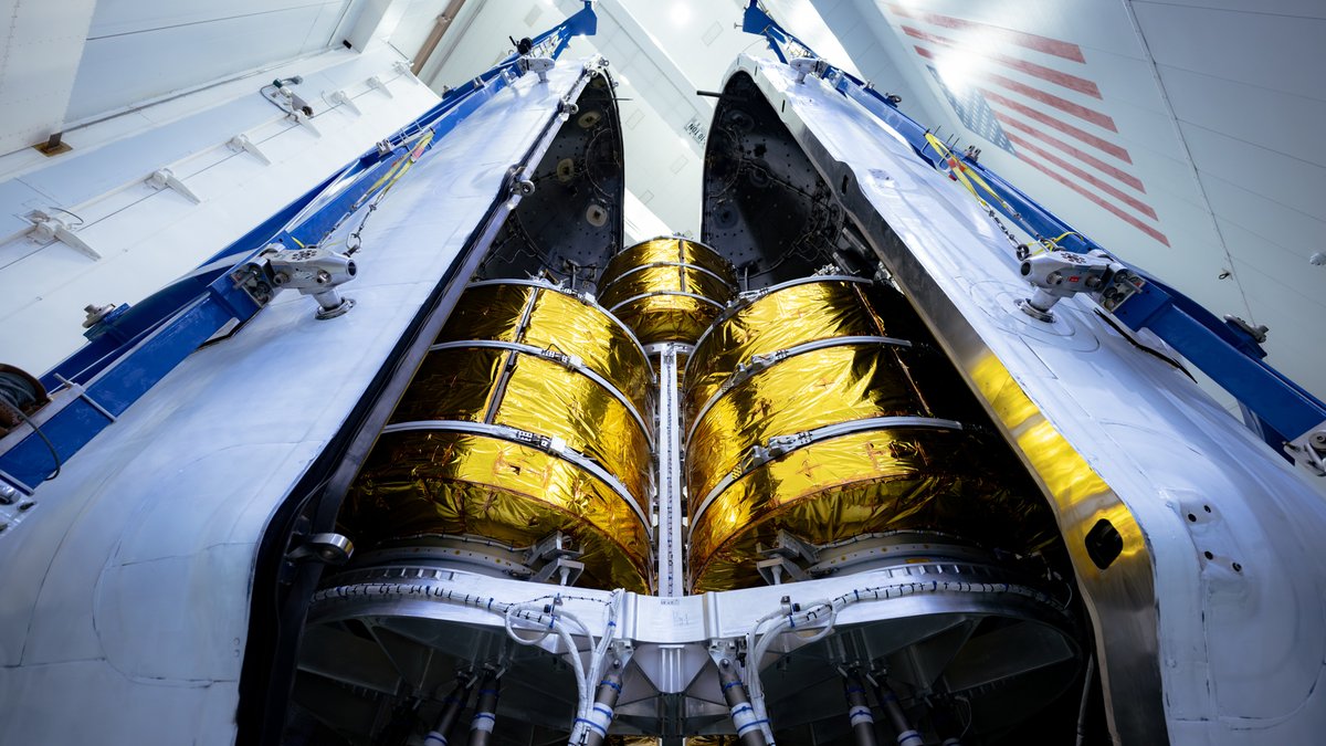
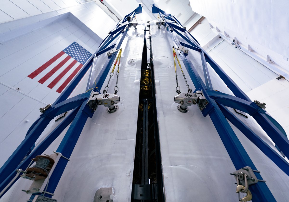
Our BlueBirds are ready to take flight! 🚀 These groundbreaking satellites are now encapsulated in the rocket, ready to launch and revolutionize global connectivity. Stay tuned for updates on the launch countdown. https://t.co/JbHIAgRMKo
#ASTSpaceMobile#BlueBirdLaunch #SpaceInnovation #LaunchDay #BlueBirdLaunch #futureofconnectivity #innovation #spacetechnology #bridgingthedivide #TheFutureIsHere