*** Incident Brief ***
As conflict escalates across the #MiddleEast, our #satellite-based #environmental#intelligence systems detected a large oil slick spreading west of Iran’s Kharg Island. Comparative analysis of #Sentinel-1 SAR VV and VH polarizations strongly indicates the presence of #oil on the water surface, with the slick producing a pronounced surface #roughness change primarily in the VV backscatter response.
This event highlights the often-overlooked environmental consequences of war and underscores the critical role of satellite-based environmental intelligence for #near-real-time #detection, #monitoring, and #assessment of unfolding disasters.
@VT_Science@UNUINWEH@EOI_lab
#RemoteSensing #SatelliteIntelligence #EnvironmentalIntelligence #SAR #Sentinel1 #OilSpill #InSAR #EarthObservation #EnvironmentalSecurity #GeospatialAI #ClimateSecurity #MiddleEast #KhargIsland #DisasterMonitoring #SpaceTech
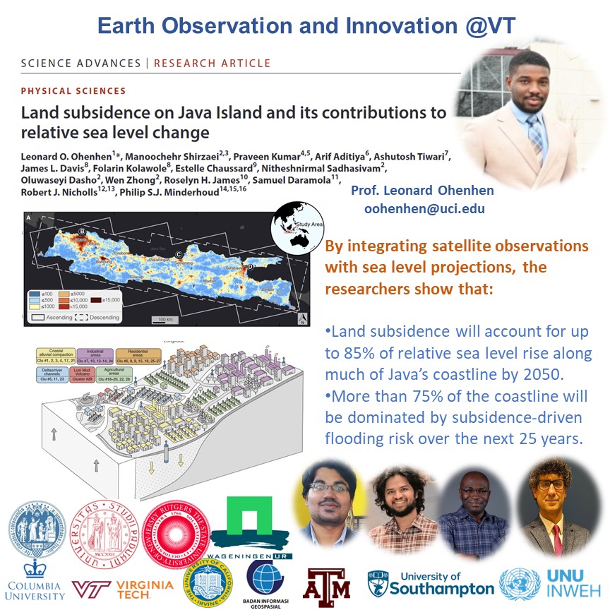
*** NEW PAPER ALERT ***
A new study in @ScienceAdvances, reveals a critical but often overlooked #driver of #coastal#flood#risk: the land itself is sinking.
Led by Dr. Leonard Ohenhen (@UCIrvine, former @virginia_tech PhD, @Leonardgeol), our work shows that across #Java Island:
• Land is subsiding up to 15 cm/year
• Subsidence will drive up to 85% of relative sea level rise by 2050
• More than 75% of the coastline will be dominated by this process
This is not just a #climate story—it’s a #human-driven hazard tied to #groundwater extraction and resource use. If we ignore subsidence, we are underestimating risk.
Proud to see this work published in Science Advances. Congrats Leonard!
#ClimateChange #SeaLevelRise #Subsidence #RemoteSensing #InSAR #CoastalRisk #EnvironmentalIntelligence
VT press: https://t.co/lImKYwqr8B
Pub: https://t.co/gXvcolK9UV
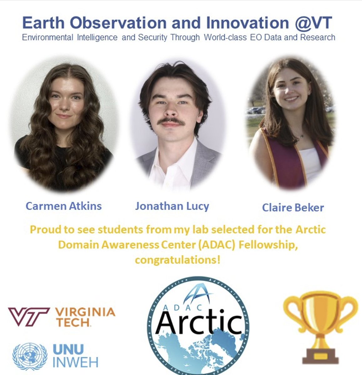
*** Congratulations!! ***
Proud to see students from my lab selected for the Arctic Domain Awareness Center (ADAC) Fellowship (https://t.co/SWZhY20n7J).
This @DHSgov-funded program supports the next generation of scientists working at the intersection of environmental intelligence, infrastructure risk, and national security in the Arctic.
Excited to see them contribute to mission-driven research with real-world impact.
Congratulations @carmen_atkins@jonbolia and Claire
@EOI_lab@vtgeosciences@VT_Science@UNUINWEH
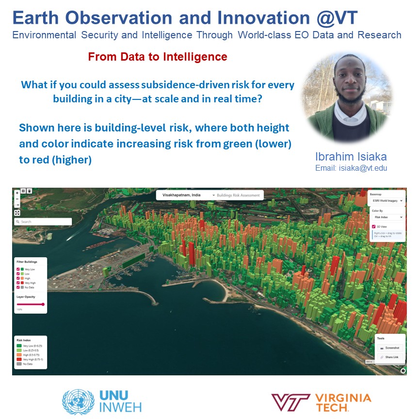
*** Research Highlight ***
What if you could assess subsidence-driven risk for every building in a city—at scale and in real time?
this is what our grad student, Ibrahim, is doing.
🚀 New results from our building damage risk framework integrating InSAR-derived vertical land motion (VLM) with building-specific characteristics
🏙️ Analysis covers ~6 million buildings across multiple cities
🌐 Developed an interactive web map showing: risk level, hazard index, vulnerability, exposure, and building height
📍 Case studies: Chennai, Colombo, and Karachi
🎨 Visualization: color (green → red) and height both represent increasing risk
🔍 Enabling scalable, building-level insights for urban resilience and risk-informed decision making
#InSAR #RemoteSensing #UrbanSubsidence #VerticalLandMotion #Geohazards #ClimateRisk #UrbanResilience #EarthObservation #SmartCities #RiskAssessment #GIS #WebGIS #DigitalTwin #Infrastructure #CityPlanning #DisasterRiskReduction #SatelliteData #Geospatial #ResilientCities
@EOI_lab@virginia_tech@UNUINWEH
🚨 New milestone in Arctic Environmental intelligence
Our team, led by two of our grad students, Carmen Atkins (@carmen_atkins) and Jonathan Lucy (@jonbolia ), has developed the first statewide map of vertical land motion across Alaska, using satellite radar (InSAR) to measure millimeter-scale ground deformation over the past decade.
Why does this matter?
Alaska hosts some of the most critical civilian and defense infrastructure in the United States. In Arctic environments, infrastructure failure rarely begins with collapse — it begins with millimeters.
These subtle but persistent shifts affect runways, drainage systems, and long-term operational resilience.
We will be presenting this work next week at the United States Departments of War (@DeptofWar) Applied Innovation Symposium.
This is a powerful example of how space-based Earth observation can move beyond mapping — toward actionable infrastructure intelligence.
Proud of the team and excited about what this enables next for Arctic resilience.
#Arctic #Infrastructure #InSAR #RemoteSensing #NationalSecurity #EnvironmentalIntelligence
@VT_Science@EOI_lab
*** Media Coverage ***
Congratulations to Dr. Ntambila Daud and Seyi Dasho, members of @EOI_lab of @VT_Science for this important research. Also, thank you @vtnews for covering the story!
https://t.co/2O4FatbNnB
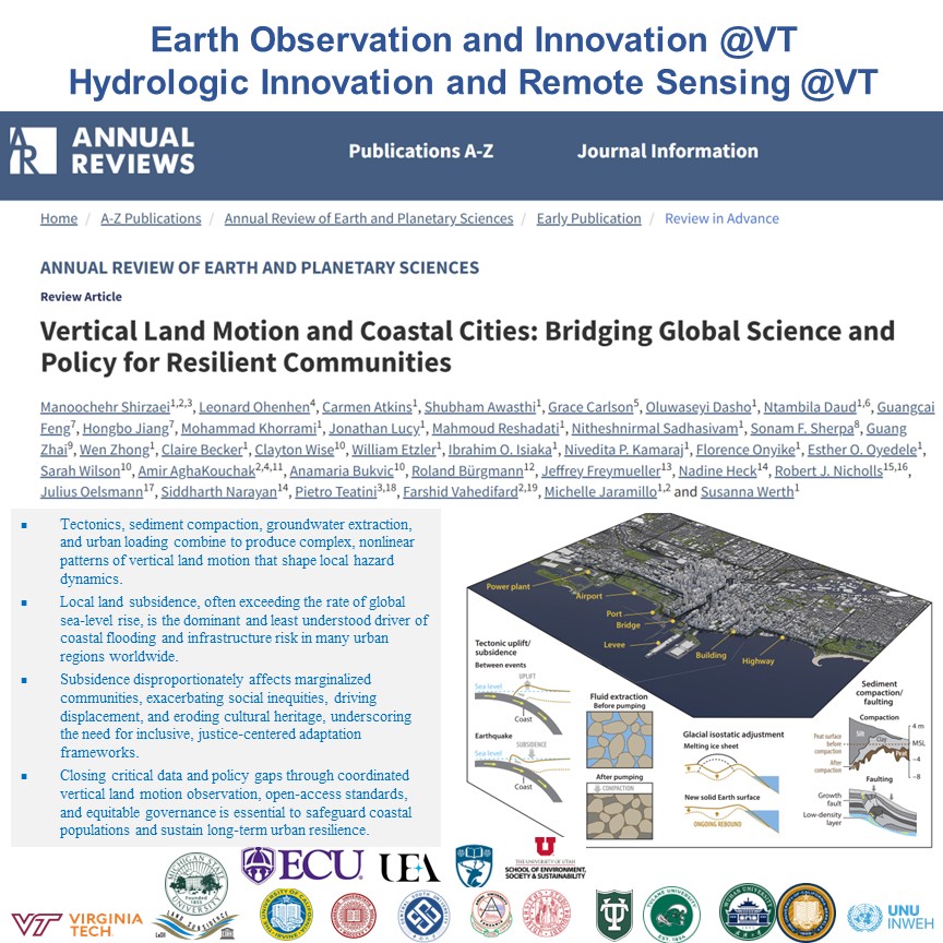
*** New Publication Alert ***
🌍 Coastal cities aren’t just facing sea-level rise — many are sinking.
Our new global, interdisciplinary review brings together #EarthScience, #engineering, #social science, and #policy to show how vertical land motion is silently amplifying #flood risk, #infrastructure failure, and #inequality worldwide.
This is a call to rethink coastal resilience — with data, justice, and decision-ready science at the core.
📖 Annual Review of Earth & Planetary Sciences
https://t.co/QquKqPVNzZ
#SinkingCities #ClimateRisk #CoastalResilience #InSAR #SeaLevelRise #Infrastructure #EnvironmentalJustice
@VT_Science@UNUINWEH
Why this work matters 👇
• Human-driven subsidence often exceeds climate-driven sea-level rise — in some cities by an order of magnitude
• Groundwater extraction, urban loading, and resource use are major — and actionable — drivers
• Flood risk, infrastructure damage, and displacement are being systematically underestimated
What’s new and different
• Global synthesis of 204 coastal cities using satellite geodesy (InSAR + GNSS)
• Connects physics → infrastructure → people → policy in one framework
• Moves beyond maps to decision-ready intelligence for planners and governments
Equity & justice lens
• Subsidence disproportionately impacts low-income and marginalized communities
• Creates spatial and intergenerational injustice — from housing loss to cultural heritage erosion
• Current adaptation plans often miss these hidden vulnerabilities
Where we need to go next
• Integrate VLM into flood models, zoning, insurance, and infrastructure design
• Expand open, global monitoring, especially in the Global South
• Deploy digital twins & decision theaters to test adaptation pathways before failure happens
*** Welcome to EOI Lab***
I am thrilled to welcome Claire Becker to @EOI_lab of @virginia_tech! Claire's research will focus on quantifying how #interacting hazards—such as #extreme#hydrologic loading, #land subsidence, and #structural degradation—#compound#overtopping risk in #dams and #levees. By moving beyond single-hazard and static assessments, Claire will enable more accurate #risk #prioritization, #proactive intervention, and #resilient flood-protection planning.
@HIRSlab@UNUINWEH
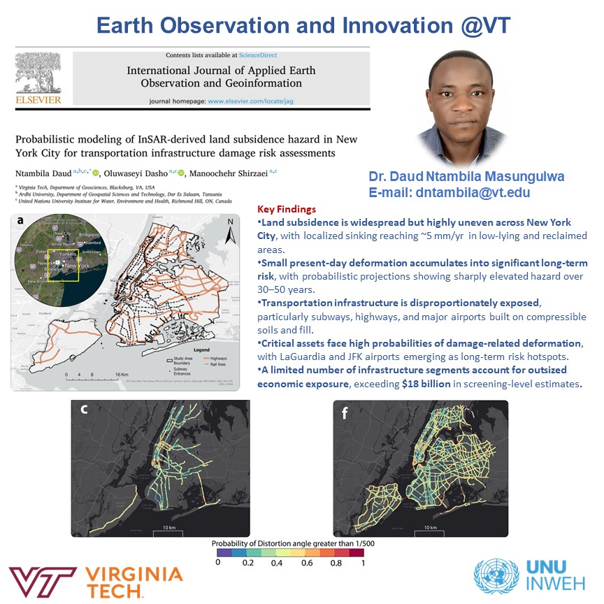
*** New Publication Alert ***
Hot off the oven, led by our postdoc, Simon, and PhD student, Seyi, we show how slow #LandSubsidence threatens #newyorkcity’s #transportation#infrastructure. We found Long-term exposure exceeds $18 billion!
Great job, Simon, and well done!
@VT_Science@EOI_lab@UNUINWEH
Pub link: https://t.co/7Q20xirwsv
🚇✈️🛣️ What’s at risk: Subways, highways, and major airports—including JFK and LaGuardia—are among the most exposed assets.
⏳ Why it matters: Even millimeter-scale ground motion, when sustained over time, can accumulate into serious infrastructure damage.
📊 What’s new: A probabilistic framework that translates satellite measurements into likelihood of damage, not just maps of sinking ground.
💰 The stakes: Long-term exposure exceeds $18 billion for a small but critical portion of NYC’s transportation network.
🌊 Climate connection: Subsidence amplifies flood risk and sea-level rise impacts in low-lying and reclaimed urban areas.
🧠 From data to decisions: Results support proactive monitoring, targeted maintenance, and smarter infrastructure investment.
🌍 Beyond NYC: The approach is scalable to other coastal and deltaic megacities worldwide.
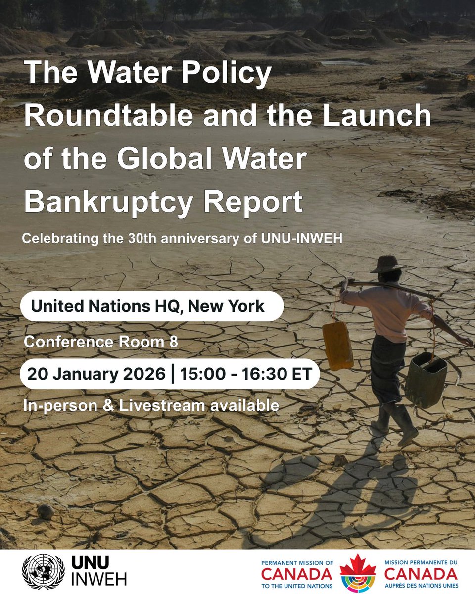
#WaterBankruptcy
Living beyond our hydrological means is no longer sustainable. 💧
Join the UN Water Policy Roundtable & launch of Global Water Bankruptcy by UNU_INWEH
📍UN HQ | 🗓 20 Jan 2026 | 🎥 Livestream available:
https://t.co/8grBG1cD8U
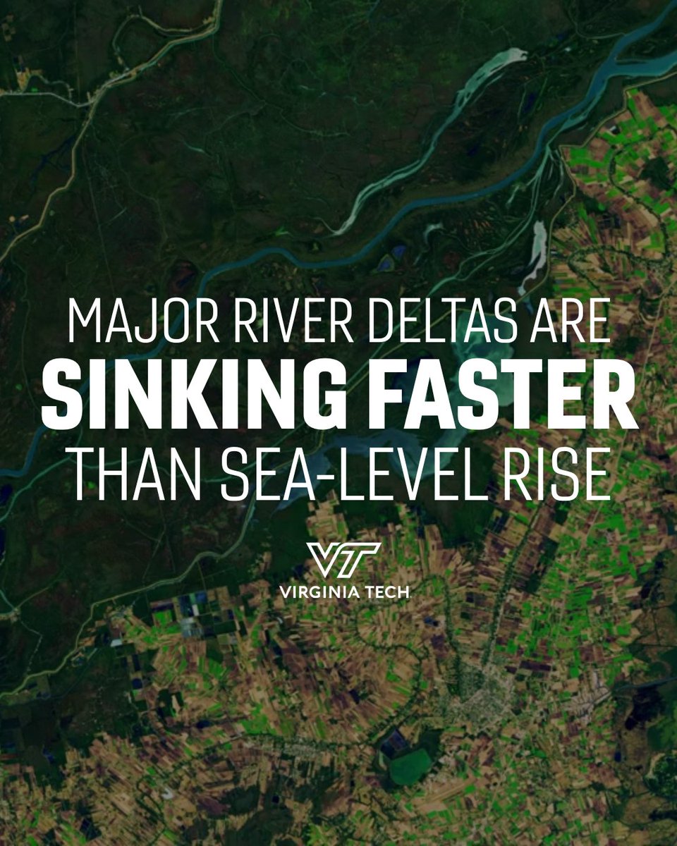
Human-driven land sinking now outpaces sea-level rise in many of the world’s major delta systems, threatening more than 236 million people, a new #VirginiaTech study finds.
🔗: https://t.co/aWsBQlgJ0I
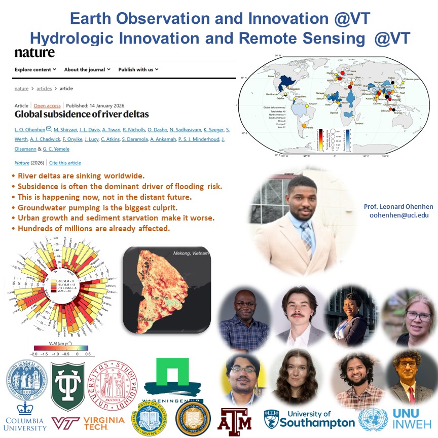
*** NEW PAPER ALERT ***
Led by our rockstar, Leonard (Assistant Prof. @UCIrvine), in collaboration with an international team, just published in @Nature. The first #global assessment of #Land Subsidence in #Deltas, #drivers, and #socioeconomic impacts. Congratulations to Leonard and team for this groundbreaking work!
@vtgeosciences@UNUINWEH@EOI_lab@HIRSlab
Pub Link: https://t.co/Mmk70VvE0t
🌍 Major Takeaways: Global Subsidence of River Deltas
• River deltas are sinking worldwide.
Over half of global delta land areais already subsiding—many at rates faster than sea-level rise.
• Subsidence is often the dominant driver of flooding risk.
In 18 of 40 major deltas, land is sinking faster than oceans are rising.
• This is happening now—not in the distant future.
Some deltas are sinking 2–10× faster than projected climate-driven sea-level rise this century.
• Groundwater pumping is the biggest culprit.
Among all human activities, groundwater extraction is the strongest driverof delta subsidence globally.
• Urban growth and sediment starvation make it worse.
Dams, levees, and rapid urbanization reduce sediment supply and increase land loading—accelerating sinking.
• Hundreds of millions are already affected.
About 236 million peoplelive in deltas where subsidence outpaces sea-level rise.
• The most vulnerable people live the lowest.
Of the 76 million people living below 1 m elevation, 84% are in rapidly sinking areas.
• Subsidence is highly uneven—even within the same delta.
Cities and infrastructure can sink much faster than surrounding rural areas, creating localized disaster hotspots.
• Climate adaptation plans are missing a key variable.
Most global risk assessments focus on sea-level rise—but ignore vertical land motion, underestimating real risk.
• The good news: subsidence is actionable.
Unlike sea-level rise, human-driven subsidence can be slowedthrough groundwater regulation, managed aquifer recharge, and sediment management.
• Failing to act now locks in irreversible risk.
Ignoring subsidence undermines flood defenses, adaptation investments, and long-term delta habitability.
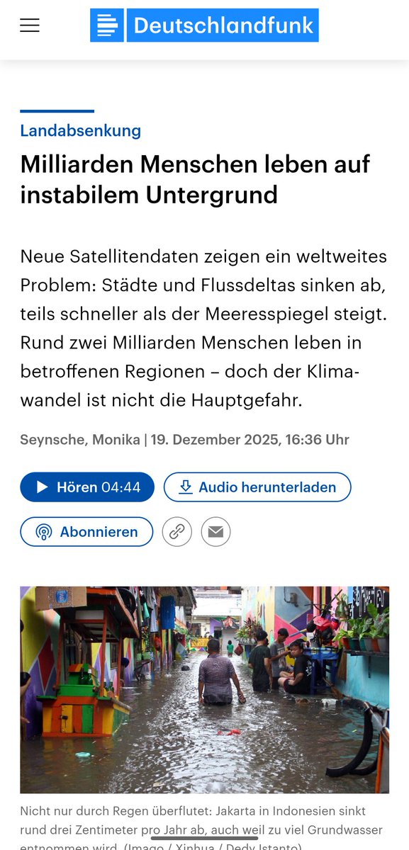
*** Media Coverage***
Excellent coverage of our research led by Seyi (PhD student @EOI_lab
) in German media. Seyi's #satellite data reveals a global problem: #cities and river #deltas are sinking—sometimes faster than #sealevels are rising. Around two billion #people live in affected regions.
Well done Seyi!
@vtgeosciences@HIRSlab@UNUINWEH
Link: https://t.co/tBUUINuYbO
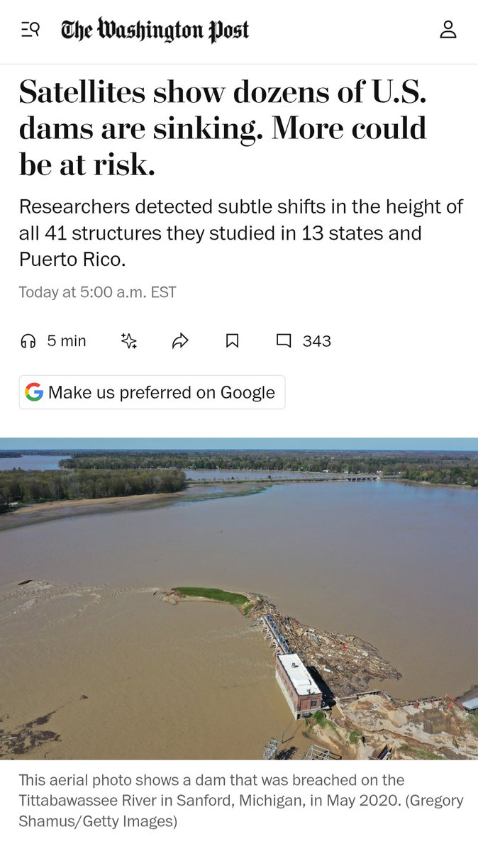
*** Media Coverage***
Here is a great article by @washingtonpost on our work safeguarding our nations #Hydropower#dams.
From space, we detect invisible #ground motion, structural stress, and climate-driven risks early, turning #EarthObservation into resilience, safety, and sustainable energy.
Well-done Mohammad!!
Link: https://t.co/SRMTpMqCa8
*** Policy Implication of Research ***
Recently, Nithesh (@nitheshnirmal), one of our PhD students, published a groundbreaking paper on #sinking#Indian#megacities in @naturesustainab . Citing this study, #NationalGreenTribunal—India’s quasi-judicial authority responsible for enforcing environmental laws—has issued a #nationwide directive to develop #LandSubsidence hazard maps for major Indian cities. I am pleased to see how quickly this research has been translated into policy. Well-done Nithesh!
@HIRSlab@vtgeosciences@EOI_lab
News Article: https://t.co/eV8zKMGXmi
Research Article: https://t.co/AMC5A4ccIY