@IIHRUIowa @IowaFloodCenter Congratulations Witek! You were an exemplary advisor and mentor. I was lucky to have been your student. Enjoy your retirement!
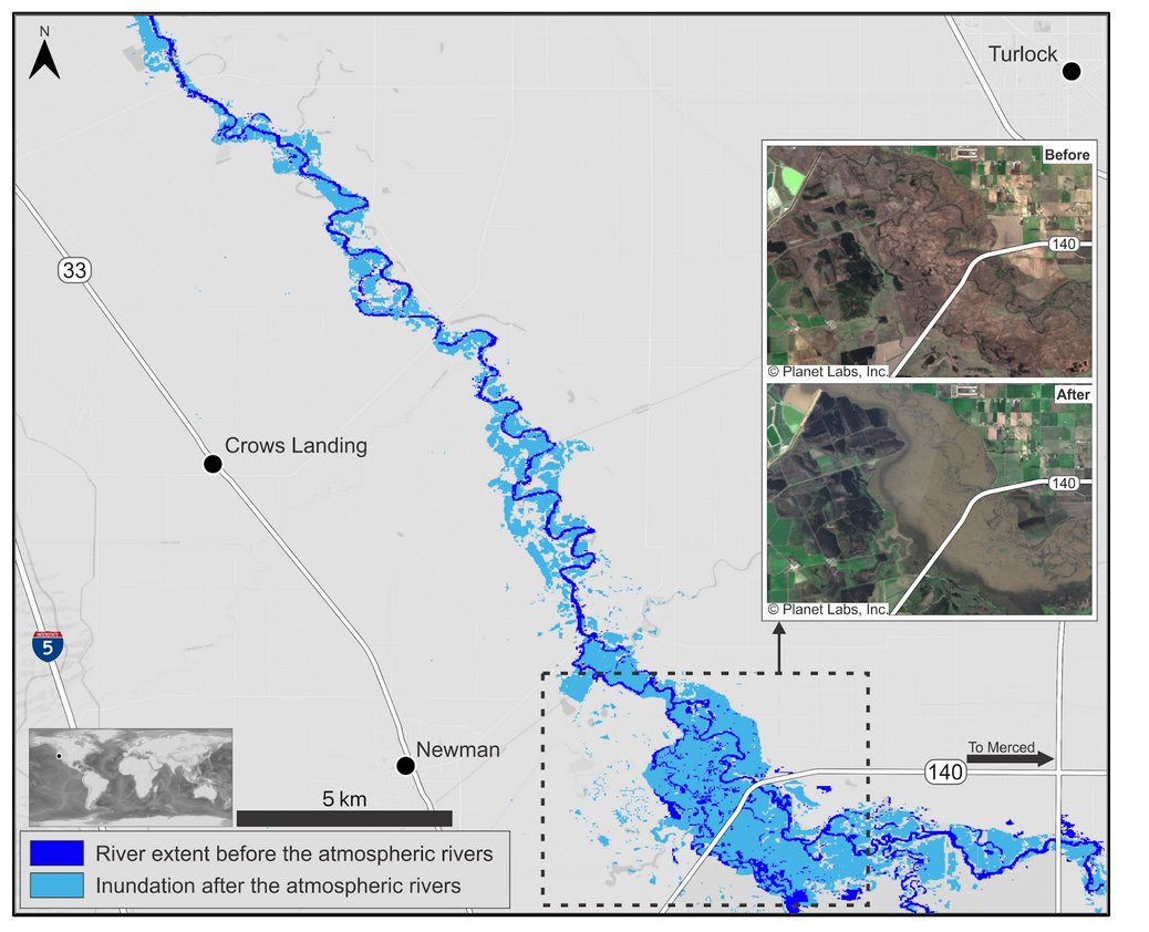
Learn how to discover, access, visualize, and mosaic @NASAJPL's OPERA near-global Dynamic Surface Water Extent (DSWx) product suite with data tutorials from NASA's #PODAAC. https://t.co/EokkfbJ17d Image: OPERA Project/Planet Labs, Inc.
#Jupyter#Python#GIS#CloudComputing
NASA’s Western Water Applications Office (WWAO) is a critical link between @NASAEarth science data, tools, and services and their use by Western U.S. water managers. Image: NASA Earth Observatory
Read about WWAO's use of NASA data in our latest article: https://t.co/DwMHQuQBB6
Possible that I may be moving on from my role at @InterceptGames soon…
I feel fortunate to have spent the last year with the Kerbal community and would miss it dearly 💚
I��m considering new opportunities in games - focusing on CM/Producer roles.
RTs appreciated, DMs open
New co-authored paper published on Nature Geoscience. We analyzed global pattern of river discharge and river storage, and found river storage is a major regulator of discharge in macro-scope view.
https://t.co/J5pQGiBc4e
ICYM: Last year's SWOT Discharge Algorithm Working Group paper describing how river discharge will be estimated in global scale was one of the top 5 papers downloaded last year! Check it out if you are curious about the inner workings of this super complex undertaking!
In 2022, the SWOT satellite mission was launched to produce estimates of river discharge on rivers where no data are currently available.
Durand et al. describe how this will work, and the expected accuracy.
https://t.co/o15NkG0bII
@NASA@CNES@csa_asc@spacegovuk
(5/6)
Our newest paper is out! The analysis led by @DinukeM quantifies the benefits of aggregating data from multiple satellites to increase the reliability of flood observations. This paper reveals the minimum observational frequency required to detect the world's greatest floods.
Merging flood impact data from Landsat, Sentinel-2, and Sentinel-1 satellites boosts useful flood image coverage, and would greatly increase the percentage of displaced populations served by high-resolution images.
New paper by Dinuke Munasinghe et al.!👉
https://t.co/koOGHUZeo3
Over the last 12 months, @CSIRO and @NASAJPL have been working on a joint feasibility to determine if a JPL imaging spectrometer can be used to deliver actionable information on water quality and aquatic ecosystems from space. First paper out now: https://t.co/DQMX9zG1lO
Job alert! The water and ecosystems group at JPL is looking to hire! If you are interested in researching the impact of fires on watersheds, check out this add: https://t.co/RGUmupO2xe
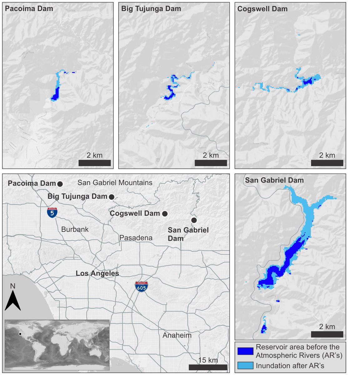
New surface water extent and surface disturbance products from the Observational Products for End-Users from Remote Sensing Analysis (OPERA) project at @NASAJPL are providing needed resources to federal agencies.
Learn how: https://t.co/oPvp6Cu4r9
We welcome you to attend the 3rd OPERA workshop on June 27, 2023. OPERA team members will present project updates, validation results, information on how to access data, and introduce forthcoming products. Participation is free! More info here: https://t.co/u7apfWwXMh
Had lots of fun making this viz for the #30DayChartChallenge and am so grateful for all the feedback and help from @USGS_DataSci ! Excited to keep working on streamflow estimation from satellites, especially with future SWOT data!
Where are flood waters flowing after major storms? How much did the land move during an earthquake or volcanic eruption?
A @NASA-sponsored project called OPERA is tracking a changing Earth by merging data from multiple satellite missions. https://t.co/ajI0tNQqYu
WOW!!! The first images from the revolutionary SWOT mission are awesome! SWOT will give us an absolutely unprecedented understanding of global water. It is also a celebration of the power of partnerships! @CNES 🚀🛰️🌊💦 https://t.co/Zxq5dagLjQ