El Niño typically has a warming effect on global temperatures, with the strongest influence often felt in the year after it develops.
It typically brings wetter conditions to some regions and drought to others, though effects vary around the world.
More 👉 https://t.co/jMd3hGUX7x
This new app can be your time machine to revisit past weather.
Weather Replay from @copernicusecmwf enables anyone to revisit the weather anywhere on the globe, hour by hour, from January 1940 up to a few days before present.
Try it out 👉 https://t.co/ieoaI4fVs0
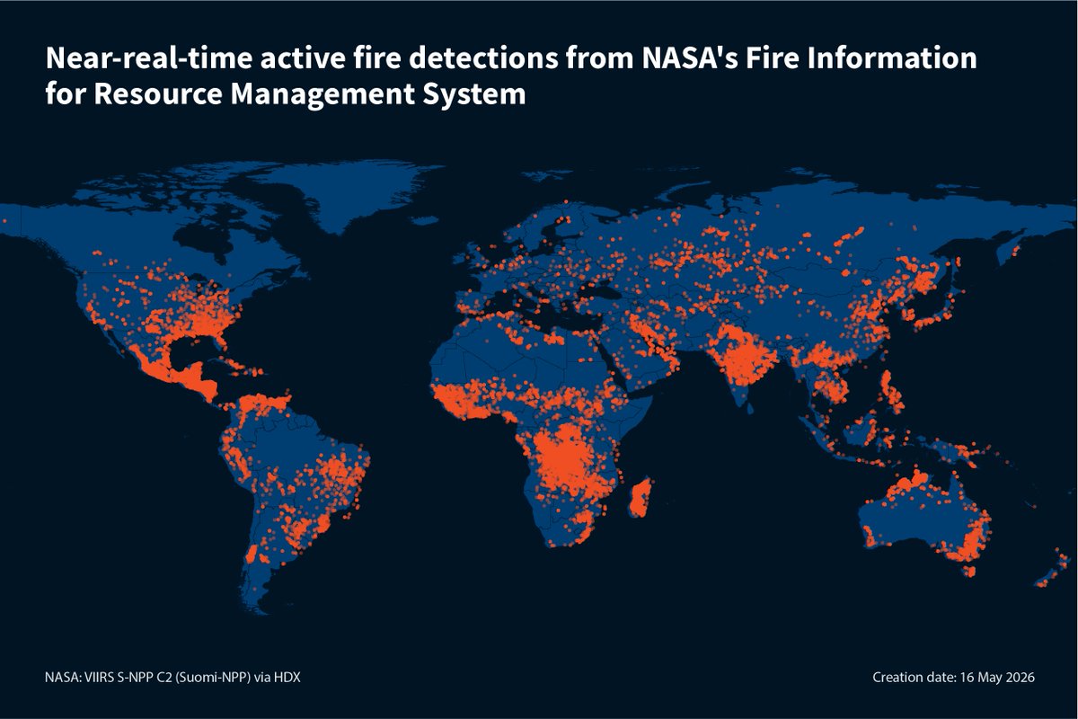
⭐ Welcome to HDX, @NASA Fire Information for Resource Management System!
NASA now shares near real-time active fire data for 196 locations on HDX. The data is available in shapefile, KML and CSV format within 3 hours of satellite observation.
Explore: https://t.co/djalMreLF9
OSINT Field Notes #8 is out.
This month: phone data and mercenaries in Sudan, stolen Ukrainian wheat, Hormuz traffic, Iran damage mapping, and a defensive guide to reducing AdTech location exposure.
https://t.co/6dAkuhGxCO
What was the weather like on the day you were born, or at a key moment in history? With the Weather Replay app from #CopernicusClimate, you can explore & compare past weather around the world, hour by hour, from 1940 to just a few days ago.
🔗Read more https://t.co/UMgAlKtl1G
"There is an implicit assumption that when the digital systems fail, we will have analogue systems to fall back on. But those are no longer there,"
“It is time to start preparing for critical digital risks more intentionally,”
https://t.co/t4wjCaKqV2
Today, we’re thrilled to announce the launch of Shapefile and 3D model import support on Google Earth. Plus, we’ve also added elevation profiles to the measure tool just for… good measure! https://t.co/vpIJA3HCv4
You’ve made it clear. You want to be able to bring more of your data and models to Google Earth’s real-world canvas. We're excited to take the next step in delivering on that promise with these new features:
🔶 Shapefiles (SHP): Render industry-standard geospatial data as performant, cloud-native layers.
💡 3D Models (GLB): Place custom architectural mock-ups, massings, and more in a visually rich context.
🗻 Elevation Profiles: View detailed terrain data in the measure tool you already know and love.
These new features are live now on Google Earth!
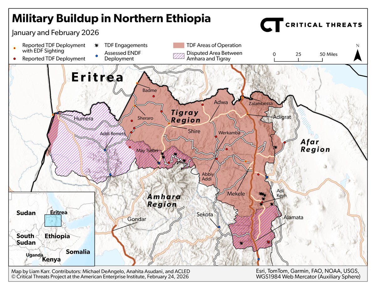
NEW | The TPLF announced its intention to reinstate the pre-Tigray war regional government, which would effectively void the Pretoria peace agreement that ended the Tigray war in 2022.
TPLF control of Tigray would increase the risk of large-scale armed conflict between the Ethiopian federal government and the TPLF, as both sides have engaged in military standoff on Tigray’s regional border since February 2026. 🧵⬇️
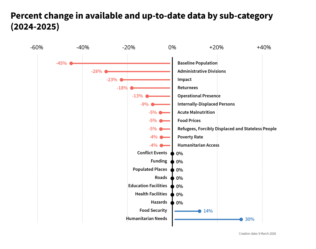
In our latest ‘State of Data’ report, we look at changes to data availability in 2025. Despite a drop in 11 sub-categories, mitigation measures and rapid reprioritization by partners resulted in only a marginal decrease in data availability across crises.
https://t.co/ELytZFz7lf
New data providers are making climate data more accessible for anticipatory action and humanitarian response. In our latest blog, we highlight 3 partners contributing climate hazard & impact data to HDX: @EU_Commission, @climatehazards & JANUS/FloodScan.
https://t.co/UbHu4jTFds
What started as a playful Dutch competition is now a powerful climate movement 🌱
Under @tegelwippen people removed over 20 million tiles since 2020 (360 soccer fields):
💧 more water absorbed
🌡️ less urban heat
🌿 more biodiversity
🏙️ healthier, more liveable cities
In CIR’s latest tracking of developments across Lebanon, we have now verified 119 pieces of footage showing reported Israeli airstrikes across the country, including 57 in Beirut, since 2 March 2026. CIR identified a further 433 likely strike locations across Lebanon through satellite imagery. Our updated map shows incidents reportedly caused by the IDF from 2 to 11 March 2026.
⭐ @GoogleResearch now shares 25 Open Buildings datasets on HDX, providing large-scale building footprint data for humanitarian use. Curated by the HDX team, the datasets use international boundaries from the UN Geospatial Hub.
Explore the data on HDX: https://t.co/84gzXqRPck
NEW MAP UPDATE - IRAN - MIDDLE EAST 🇮🇷🇮🇱🇺🇸 DAY 4
As day 4 of the war between Israel and the USA against Iran is starting, here is a new map update. The US and Israeli air forces continued to gain total air control above Iran yesterday, alowing them to bomb tens of missile launchers, rear bases and command centers, especially in Tehran.
However, Iran continued to strikes back accross the Middle East with multiple drones and missiles, with some of them reaching critical US bases. Yesterday, Hezbollah joined the fight in Lebanon, followed by multiple Israeli airstrikes in the country. In Irak and Bahrain, two Shia majority states, part of the population protested around the US embassies.
The situation in the Middle East is worsening. The USA called all their citizens from every country in the region to leave, while Iran expanded their drone and missile strikes into Saudi Arabia, striking the crucial Ras Tanura/ARAMCO reffinery, as well as US embassy in Riad. Iranian strikes in Iraq, Kuwait, Bahrain, Qatar, the UAE, Jordan, Cyprus and Israel continued, followed by a strong regional reaction. Some of the regional actors (Qatar and UAE) published data of the Iranian strikes (most of them shot down), while the numbers remains uncertain for other states. In Kuwait, 3 american F16 were shot down by error in the morning.
Yesterday, if US and Israeli strikes concentrated in Tehran, I added additionnal targeted cities to the map, including coastline cities and rear bases. Satellite images confirmed massive US/ISR strikes on Tabriz, Natanz, Bandar Abbas and Konarak.
Some points :
▫️Despite 4 days of shelling, the Islamic Republic didn't move, the Iranian people is still not on the streets
▫️Iranian counter-strikes are still ongoing, with one big question concerning the munition stocks
▫️Gumf countries and Israel may soon be short on air-defense missiles and strike elements, 20 US cargo planes are en route for the region.
Thanks for following, I will continue to update the map with another update like this in the middle of the day.
We did the math on the US naval buildup in the Caribbean. The total: $2.9B. At its height, costs topped $20M a day. Much was already funded, but combat operations cost extra -- and opportunity costs are difficult to quantify.
Our latest for @business: https://t.co/CYnUlQeRRJ
Three years ago, #UKISAR teams were deployed to Türkiye in response to the devastating earthquakes that struck both Türkiye and Syria, causing widespread destruction and loss of life.
Our teams, supported and funded by @FCDOGovUK worked alongside international partners and local emergency services, carrying out complex urban search and rescue operations in extremely challenging and hazardous conditions.
Their efforts focused on locating and rescuing survivors, supporting affected communities, and assisting with the wider humanitarian response.
Our thoughts remain with everyone affected, and they continue to be in our thoughts. 🧡
#UKISAR #SearchAndRescue #HumanitarianResponse #TurkeySyriaEarthquake #EmergencyResponse #InternationalPartnership #FCDO
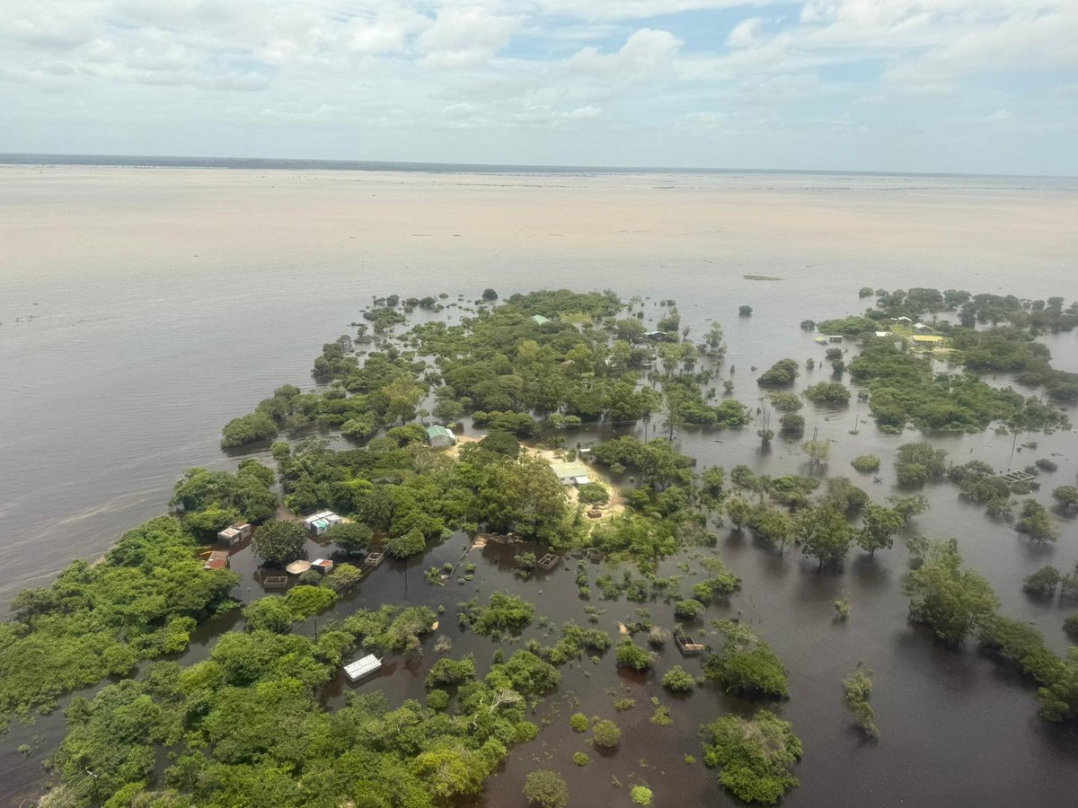
#UKISAR has been deployed to Mozambique to support flood rescue operations following devastating flooding caused by extreme rainfall.
Funded and supported by the @FCDOGovUK , UK fire & rescue specialists and a medical team are now operating in Maputo Province and Xai-Xai, working with local authorities to rescue people trapped by floodwaters.
More info @NFCC_FireChiefs :
https://t.co/cudFkTAZmF