14 years ago, we got together with an idea to build a better way to move value. What happened next was something none of us could have built alone.
And by "us," I don't just mean the three of us.
I mean the developers, validators, businesses, community members, and everyone who helped shape XRP into what it is today.
Happy Birthday, XRP!
BLOWING dust along this outflow boundary in West Michigan!
Poor visibility with tree branches blowing across the road!
📍Coopersville, MI
@MiStormChasers
a tornado today near Merrillan, Wisconsin -
I contrast cooked the piss out of this because it’s fun seeing the sub vorts dancing in the rain under there - today was a really REALLY awful chase for me so felt lucky to catch this at all
“You can see the surface of the Moon…we just went sci-fi.”
On flight day seven, images from our @NASAArtemis II crew amazed, turning science fiction to reality. From the lunar far side to a solar eclipse from the Moon, the views are EVERYTHING. No pressure to pick a favorite.
A medium risk (MSC level 3 of 6) has been issued for the chance of severe thunderstorms this afternoon, April 2nd, 2026 for portions of SW Michigan.
Discussion
Since yesterday, we have upgraded the probabilities by one for each hazard. Models have shown an uptick in potential for scattered squall lines this afternoon with a stronger damaging wind risk, plus a couple embedded tornadoes. With supercellular mode a potential as well, we went ahead and tossed a low-end hail risk over the SW part of the Lower Peninsula. Generally speaking, it will be a low instability, high shear type of day. Lot of wind, but not as much storm fuel due to clouds and early-day rain that we are currently experiencing. In order to chip away at any excess storm fuel, we will need continued rain into the late afternoon hours. The odds of each hazard happening are shown below, which if you want to think about it the opposite way, the statistics are on your side that you don't get severe today.
Peak odds for each hazard:
Damaging winds of 60 mph: 15-34%
Tornadoes: 4-10% (some strong)
Large 1"+ diameter hail: 1-3%
Storm motion will be off to the northeast at 60-70 mph. This is actually important information for those who do get a severe warning, as storms will be in your vicinity before you know it, if a warning is issued a county ahead of you. General thunderstorms are possible all the way north to the M-32 corridor, but severe should remain south of US-10 for the most part, as shown in the maps. The upper peninsula is not expected to get severe weather today, as they are dealing with ice and snow at the current time.
If any severe thunderstorm warnings, or tornado warnings, are issued today, we will be live tracking them as always. As our motto states, we got you covered from beginning to end here at Michigan Storm Chasers.
Peak timing for severe weather will be 2 pm EDT to 2 am EDT, with the highest likelihood of a warning beyond 5 pm EDT.
– Trusted Partner of the Day –
Top Notch Tree Care LLC | From Lansing to Jackson, Top Notch Tree Care has you covered for all tree care services, so be sure to call today at 517-712-3721, and let them know MSC sent you!
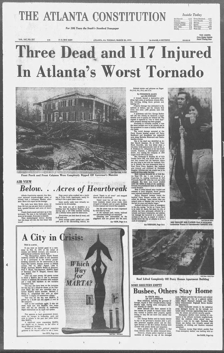
ON THIS DATE IN 1975: An F3 tornado struck the northern part of Atlanta, earning the nickname "Governor's Tornado" for severely damaging the Georgia Governor's Mansion.
The tornado carved a 14.8-mile path through Fulton County, starting in West Atlanta and moving northeast at about 50 mph before lifting near Brookhaven. It caused 3 deaths, 152 injuries, and $56.5 million in damage, displacing 550 families.
George Busbee was Georgia's governor at the time; he and his family sheltered inside the mansion as the storm blew off its roof and toppled front columns, but no one there was hurt.
Flights will likely be impacted! Locally serious flash flooding of the desert is expected. This is a bizarre, anomalous and truly rare setup for the region.
🌪️Drill in Kalamazoo
I recorded this video to demonstrate that sirens are intended as an OUTDOOR alert only. As you’ll see, when I step into our garage, the sound is very faint. While a great tool, outdoor sirens should never be your first line of defense for this very reason.
Tucson's beloved Fourth Avenue Spring Street Fair is making a comeback, bringing with it three days packed with art, music and food. https://t.co/7EnxXzlIiC