With the latest data in I'm going to go ahead an give my thoughts about this evening. In general, everyone in the enhanced and moderate risk should take this seriously. @NWSWichita and @NWSNorman have both been putting out fantastic graphics and discussions. #kswx#okwx
@WxLiz Liz, there were definitely a couple of days when I worked in Wichita where we would have a conditional risk due to the cap. Messaging a marginal with the potential for a strong tornado was difficult. This change would make that a lot easier. Can't wait to see it in action!
I really hope we get a good after action report. It would make for a good learning opportunity so that these situations do not happen again. For those who do want to share criticism, remember to do it respectfully.
Many of my colleagues may disagree with my opinion, but I do believe we should be more open to criticism. Yes mistakes happen, but instead of becoming defensive about it let's reflect on what went wrong and do our best to fix the issues.
Gaps in messaging can grow larger and eventually the people you are trying to reach don't trust the message and ignore it. That said, effective criticism is not centered in hate. It's perfectly fine to ignore messages that stem from places of hate.
At 5:55PM, quarter to golf ball sized hail was reported in Salina. A 100 mph measured wind gust was just reported at Salina Airport at 6PM. Get into shelter now if you are in Salina! #kswx
@jam_ezcellular The radar dreams seemed to have stopped when I got to Guam. They've been replaced by spontaneous super typhoons that weren't forecasted instead.
Please have multiple ways to receive a warning! With night time tornadoes possible, tonight may be one of those nights to sleep in the safe room/basement if possible. The best time to plan is right now, not when the watch or warning is issued. Stay safe! #kswx#okwx
Keep forecasters at @NWSWichita, @NWSNorman, @NWStulsa, @NWSSPC, & other affected offices in your prayers today. Their dedication to the mission is 2nd to none, you are in good hands. But that dedication when your own community/family is under a 5/5 threat, can be very stressful.
We've seen what an outbreak that has a similar setup but with more questions and a lower-end environment can do. I hope we see a messy storm mode, but I suspect that won't be the case. Please follow your local NWS's advice! I wish all my friends at ICT good luck! #kswx#okwx
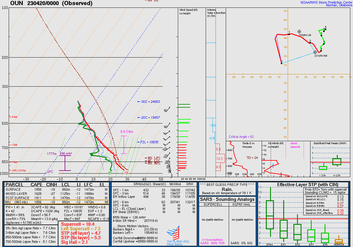
Kinematically speaking, I'm not sure it can get too much better than last year, but it doesn't need to. Anything similar would push this event to the extreme when combined with MLCAPE values in the 3000 to 4000 j/kg range.
The environment today will also be better thermodynamically than last year. Although we don't have all of the 00z data for OUN, we can see the surface dew was in the mid 60s. The 00z HRRR has upper 60 to low 70 dews pushing into Kansas. This gives the atmosphere some extra juice.
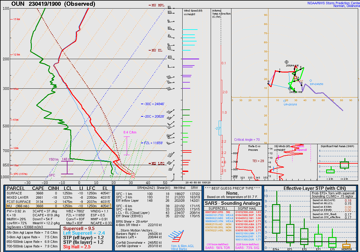
4/19 had a very similar orientation to what the models are showing but was positioned farther west, so there was less forcing. Both orientation and position are critical to a tornado outbreak. The upper jet was just outside of the warm sector, which helped keep storms isolated.
The supercell in Kansas produced 8 or 9 tornadoes and I believe it was one or two that produced 11 in Oklahoma. The supercells later today will have less space to work with due to more forcing, but tornadoes may form over a larger area instead of clustered in isolated spots.
Many have already highlighted multiple historic outbreaks, but I was like to mention the 4/19/2023 mini-outbreak across the Plains. This was fresh on my mind since it has been the only set of tornado warnings I have issued in my career. I still remember the setup clearly.
With the latest data in I'm going to go ahead an give my thoughts about this evening. In general, everyone in the enhanced and moderate risk should take this seriously. @NWSWichita and @NWSNorman have both been putting out fantastic graphics and discussions. #kswx#okwx